The Determination of Minimum Flows for Sulphur Springs, Tampa
The Determination of Minimum Flows for Sulphur Springs, Tampa The Determination of Minimum Flows for Sulphur Springs, Tampa
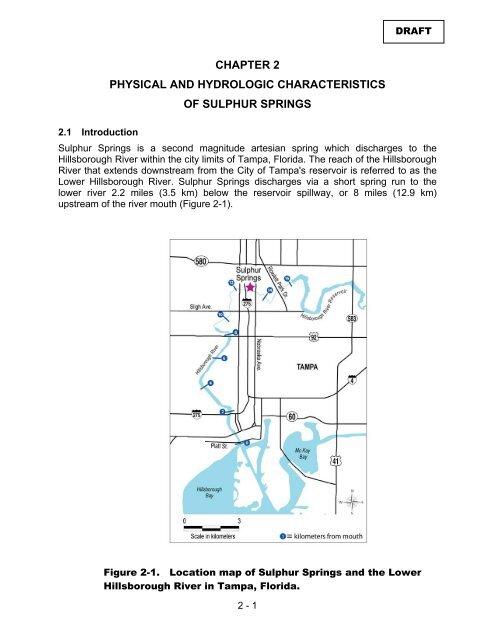
DRAFT CHAPTER 2 PHYSICAL AND HYDROLOGIC CHARACTERISTICS OF SULPHUR SPRINGS 2.1 Introduction Sulphur Springs is a second magnitude artesian spring which discharges to the Hillsborough River within the city limits of Tampa, Florida. The reach of the Hillsborough River that extends downstream from the City of Tampa's reservoir is referred to as the Lower Hillsborough River. Sulphur Springs discharges via a short spring run to the lower river 2.2 miles (3.5 km) below the reservoir spillway, or 8 miles (12.9 km) upstream of the river mouth (Figure 2-1). Figure 2-1. Location map of Sulphur Springs and the Lower Hillsborough River in Tampa, Florida. 2 - 1
DRAFT The spring and its run lie in a small city park in a highly urbanized setting. For many years Sulphur Springs was a major recreational resource that was used for swimming and bathing by the citizens of Tampa. The current configuration of retaining walls and water control structures at Sulphur Springs reflect the historic use of the spring for recreation, and in later years, for water supply. Historic photos show that the spring pool was enclosed by a circular concrete rim by the early 1900s (Figure 2-2A). Water flowed from this pool through a water control structure to the spring run, which had a weir near its mouth that was built to maintain suitable water levels for swimming and wading. Over various periods, facilities were maintained at the spring system that included pavilions, a water slide, diving boards and sand beaches, and Sulphur Springs was a major attraction for bathing and social gatherings (Figure 2-2B). Figure 2-2A. Photograph from1908 showing the concrete rim enclosing the Sulphur Springs Pool. Figure 2-2B. Public swimming and recreation at Sulphur Springs during the early 1900s. 2 - 2
- Page 1 and 2: The Determination of Minimum Flows
- Page 4 and 5: DRAFT TABLE OF CONTENTS List of Tab
- Page 6: 4.5 Goal 1 - Minimize the incursion
- Page 10 and 11: DRAFT LIST OF FIGURES Chapter 2 - P
- Page 12 and 13: Fig. 3-13 Fig. 3-14 Fig. 3-15 Fig.
- Page 14 and 15: Fig. 5-7 Fig. 5-8 Fig. 5-9 Fig. 5-1
- Page 16 and 17: Acronyms and Definitions DRAFT AMO
- Page 18 and 19: DRAFT Executive Summary The Southwe
- Page 20: DRAFT below 19 feet NGVD of 1929. T
- Page 24 and 25: CHAPTER 1 PURPOSE AND BACKGROUND OF
- Page 26 and 27: DRAFT water, or aquifer, provided t
- Page 28: DRAFT one the indicators were the f
- Page 33 and 34: DRAFT Figure 2-3. Recent photograph
- Page 35 and 36: 2 - 6 DRAFT
- Page 37 and 38: DRAFT -5 -4 -3 -2 -1 0 1 2 3 0.4 4
- Page 39 and 40: DRAFT 10.0 Yrly_Pumpage.grf 15 Annu
- Page 41 and 42: DRAFT 1999 2000 2001 2002 2003 35 D
- Page 43 and 44: DRAFT Figure 2-14. Return flow stru
- Page 45 and 46: DRAFT 40 Jan. Feb. Mar. Apr. May Ju
- Page 47 and 48: DRAFT due to withdrawals for public
- Page 49 and 50: DRAFT Figure 2-19 . Temporal trend
- Page 51 and 52: DRAFT Figure 2-20. Temporal trends
- Page 53: DRAFT In comparison to specific con
- Page 57 and 58: DRAFT average daily withdrawals for
- Page 59 and 60: DRAFT Figure 2-25. Average specific
- Page 61 and 62: DRAFT withdrawal rate of 31 cfs dur
- Page 63 and 64: DRAFT Table 2-2. Sulphur Springs su
- Page 65 and 66: DRAFT These plots indicate that his
- Page 67 and 68: DRAFT CHAPTER 3 ECOLOGICAL RESOURCE
- Page 69 and 70: DRAFT 3 Run_Riv_Stg.grf Water Surfa
- Page 71 and 72: DRAFT 3.4 Salinity in the spring ru
- Page 73 and 74: DRAFT 1999 2000 2001 2002 2003 2004
- Page 75 and 76: DRAFT pumping events resulted in sa
- Page 77 and 78: DRAFT As discussed in Section 2.5.3
DRAFT<br />
CHAPTER 2<br />
PHYSICAL AND HYDROLOGIC CHARACTERISTICS<br />
OF SULPHUR SPRINGS<br />
2.1 Introduction<br />
<strong>Sulphur</strong> <strong>Springs</strong> is a second magnitude artesian spring which discharges to the<br />
Hillsborough River within the city limits <strong>of</strong> <strong>Tampa</strong>, Florida. <strong>The</strong> reach <strong>of</strong> the Hillsborough<br />
River that extends downstream from the City <strong>of</strong> <strong>Tampa</strong>'s reservoir is referred to as the<br />
Lower Hillsborough River. <strong>Sulphur</strong> <strong>Springs</strong> discharges via a short spring run to the<br />
lower river 2.2 miles (3.5 km) below the reservoir spillway, or 8 miles (12.9 km)<br />
upstream <strong>of</strong> the river mouth (Figure 2-1).<br />
Figure 2-1. Location map <strong>of</strong> <strong>Sulphur</strong> <strong>Springs</strong> and the Lower<br />
Hillsborough River in <strong>Tampa</strong>, Florida.<br />
2 - 1


