Firth of Tay to Moray - Sustrans
Firth of Tay to Moray - Sustrans
Firth of Tay to Moray - Sustrans

You also want an ePaper? Increase the reach of your titles
YUMPU automatically turns print PDFs into web optimized ePapers that Google loves.
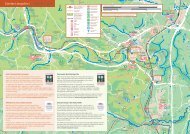
On-road National Cycle Network section<br />
Traffic-free National Cycle Network section<br />
Other routes<br />
Time: The time given <strong>to</strong> complete a route is calculated on an<br />
average travelling time <strong>of</strong> 7 miles or 11 km per hour. This<br />
allows for a leisurely cycling pace or for plenty <strong>of</strong> s<strong>to</strong>ps. Times<br />
and distances given for linear routes are for one way only.<br />
Whilst every effort has been made <strong>to</strong> achieve accuracy <strong>of</strong><br />
information in this booklet at time <strong>of</strong> publication, <strong>Sustrans</strong><br />
can take no responsibility for: loss or injury (including fatal) <strong>to</strong><br />
persons; loss <strong>of</strong> damage <strong>to</strong> property or equipment; trespass,<br />
irresponsible riding or any other mishap that may be suffered<br />
as a result <strong>of</strong> following route descriptions in this booklet.<br />
The 6000 km North Sea Cycle Route<br />
is the world’s longest signed<br />
international cycle route, passing<br />
through 8 countries around the<br />
North Sea. It mainly follows Route 1<br />
<strong>of</strong> the National Cycle Network up the east coast<br />
<strong>of</strong> the UK. www.northsea-cycle.com<br />
St Andrews <strong>to</strong> <strong>Tay</strong>port<br />
p6<br />
<strong>Tay</strong>port <strong>to</strong> Invergowrie<br />
p8<br />
Broughty Ferry <strong>to</strong> Arbroath p10<br />
Perth <strong>to</strong> Pitcairngreen<br />
p12<br />
Birnam Dunkeld Cycle<br />
p14<br />
Johnshaven <strong>to</strong> Inverbervie p16<br />
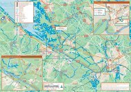
Southern area<br />
Inverbervie<br />
Johnshaven<br />
Montrose<br />
S<strong>to</strong>nehaven<br />
Miles<br />
0<br />
5 10 15<br />
Dunkeld<br />
Birnam<br />
0 5 10 15 20 25<br />
Kilometres<br />
Dundee<br />
Broughty Ferry<br />
Carnoustie<br />
Arbroath<br />
Pitcairngreen<br />
Invergowrie<br />
<strong>Firth</strong> <strong>of</strong><br />
<strong>Tay</strong><br />
<strong>Tay</strong>port<br />
Perth<br />
Newburgh<br />
Falkland<br />
St Andrews<br />
Map and text © <strong>Sustrans</strong> 2009<br />
Maps are reproduced from Ordnance<br />
Survey material with the permission <strong>of</strong><br />
Ordnance Survey on behalf <strong>of</strong> the Con<strong>to</strong>ller<br />
<strong>of</strong> Her Majesty’s Stationery Office © Crown<br />
copyright. Unauthorised reproduction<br />
infringes Crown copyright and may lead <strong>to</strong><br />
prosecution or civil proceedings.<br />
Licence number 100020852<br />
3<br />
4