FINAL VERSION FOR APPROVAL - Sdn Bhd - WWF Malaysia
FINAL VERSION FOR APPROVAL - Sdn Bhd - WWF Malaysia
FINAL VERSION FOR APPROVAL - Sdn Bhd - WWF Malaysia

Create successful ePaper yourself
Turn your PDF publications into a flip-book with our unique Google optimized e-Paper software.
Gunung Stong State Park Preliminary Management Plan<br />
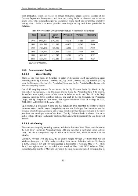
from production forests are based on annual production targets (coupes) decided at the<br />
Forestry Department headquarters, and there are cutting limits on diameter size at breastheight<br />
(dbh), while stateland and private land are not coupe-based, and nor are they limited by<br />
cutting sizes. Table 1.10 below provides some insight on log and timber production in<br />
Kelantan.<br />
Table 1.10: Production Of Major Timber Products in Kelantan (in cubic metres)<br />
Year Logs Sawn<br />
Timber<br />
Plywood Veneer Moulding<br />
1995 2,090,461 2,403,000 50,298 43,058 6,004<br />
1996 1,886,545 935,332 40,402 33,340 15,600<br />
1997 1,757,492 750,380 42,351 35,776 17,979<br />
1998 1,146,382 425,955 27,242 15,458 8,962<br />
1999 1,081,987 451,742 33,510 10,554 3,523<br />
2000 1,339,501 543,246 24,970 3,088 3,327<br />
Source: FDPM (2001).<br />
1.5.9 Environmental Quality<br />
1.5.9.1 Water Quality<br />
There are six river basins in Kelantan (in order of decreasing length and catchment area)<br />
consisting of the Sg. Kelantan (13,000 sq km), Sg. Golok (1,000 sq km), Sg. Semerak (200 sq<br />
km.), Sg. Kemasin (48 sq km), Sg. Pengkalan Chepa, and the Sg. Pengkalan Datu basins, with<br />
45 water-sampling stations.<br />
Out of 45 sampling stations, 34 are located in the Sg. Kelantan basin, Sg. Golok, 4; Sg.<br />
Semerak, 2; Sg. Kemasin, 1; Sg. Pengkalan Chepa, 1; and Sg. Pengkalan Datu, 3. In general,<br />
the surface water quality status of the rivers in Kelantan are in the Class II in the WQI<br />
category, excepting three sampling stations, one each in the Sg. Semerak, Sg. Pengkalan<br />
Chepa, and Sg. Pengkalan Datu basins, that register consistent Class III readings in 2000,<br />
2001, 2002, and 2003 (DOE Kelantan, 2004).<br />
Sg. Semerak, Sg. Pengkalan Chepa, and Sg. Pengkalan Datu recorded moderately polluted<br />
status due to their smaller basins, less pristine sources, and discharges from industries, and the<br />
presence of solid wastes, domestic and sewage pollution in their basins which are in the more<br />
populated and developed areas of the State. The Sg. Kelantan basin is cleaner, due to its<br />
higher volume of water (and greater dilution effect), and with its sources in the less developed<br />
uplands.<br />
1.5.9.2 Air Quality<br />
There are two air quality sampling stations, both in the district of Kota Bharu – one located at<br />
the S.M. Dato’ Hashim in Pengkalan Chepa (A1), and the other in the Sultan Ismail College<br />
(A2). The site in Pengkalan Chepa is within an industrial area, while the other is in the<br />
suburbs.<br />
Generally, between 1998 and 2002, the air quality ranged between Good (less than 50) and<br />
Moderate (between 51 to 100), rarely exceeding 50 on the Air Pollution Index (API), though<br />
in 1998, a spike of 104 and 103 were recorded in the months of April and May for A1, while<br />
for A2, the highest level was recorded in the month of May, 1998 (DOE Kelantan, 2004).<br />
Incidentally, the months of March to May are in the inter-monsoonal period, corresponding to<br />
15