FINAL VERSION FOR APPROVAL - Sdn Bhd - WWF Malaysia
FINAL VERSION FOR APPROVAL - Sdn Bhd - WWF Malaysia
FINAL VERSION FOR APPROVAL - Sdn Bhd - WWF Malaysia

Create successful ePaper yourself
Turn your PDF publications into a flip-book with our unique Google optimized e-Paper software.
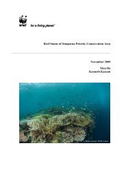
Gunung Stong State Park Preliminary Management Plan<br />
and droppings, calls and/or direct sightings are good indicators of improving general forest<br />
health, and may be related to the absence of human disturbances and reduction of hunting<br />
pressures.<br />
GSSP staff must be trained to recognise these biological indicators and to formulate remedial<br />
measures, whether by direct intervention (e.g. increased enforcement, re-stocking of absent or<br />
declining wildlife species, silvicultural treatments, etc.) or benign intervention (e.g. closing an<br />
area off, and letting natural regeneration to happen).<br />
General observations on wildlife (direct sightings, calls, prints, droppings), plants (presence<br />
and relative abundance of primary, pioneer or invasive alien species) and habitats (incidence<br />
of erosion, human disturbance, etc.) during patrols must be reported and filed, and the trends<br />
(if any) analysed for remedial measures. Park workers must be well-versed in rapid<br />
biological assessment methods.<br />
6.13 Signposting<br />
Signposting serves a number of purposes – as a navigational tool, as a method for informing<br />
visitors of pertinent information concerning the park (including codes of conduct), as well as<br />
to educate visitors (e.g. through the use of interpretive signage). To reduce confusion,<br />
warning notices, navigational signs and interpretive signs, should be separately color-coded.<br />
6.13.1 Navigational Signposting<br />
Without navigational signposts, visitors will have difficulty determining their position within<br />
GSSP, and will not know if they had inadvertently strayed into areas off-limits to visitors, and<br />
by doing so, may be disturbing an environmentally sensitive area. If visitor areas in GSSP are<br />
well sign-posted, the absence of signposts would indicate to visitors that they are in a place<br />
where they should not be. Navigational signposts include summit signposts, campsite<br />
signposts, and directional signposts.<br />
Summit signposts are signposts that are placed on the popular summits, detailing the altitude,<br />
and name of the summit. These signs should be placed at the summit of G. Ayam, G. Stong,<br />
G. Tera, G. Che Tahir, G. Che Kob, G. Menyelit, and G. Birut, as detailed in Table 6.10.<br />
Table 6.10: Placement of Summit Sign Posts<br />
No. Name of Summits Map Coordinates Elevation (m)<br />
1. G. Ayam N 437652<br />
1,500<br />
E 591049<br />
2. G. Stong N438710<br />
1,415<br />
E590288<br />
3. G. Tera N 434747<br />
1,545<br />
E 591542<br />
4. G. Che Tahir N 437829<br />
1,415<br />
E 592589<br />
5. G. Kob N 439202<br />
1,266<br />
E 590515<br />
6. G. Menyelit N 437867<br />
1,480<br />
E 590176<br />
7. G. Birut N 439556<br />
E 589475<br />
1,390<br />
90