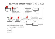
District Intergrated Land Use Plan - Ngwaketse Land Board
District Intergrated Land Use Plan - Ngwaketse Land Board
District Intergrated Land Use Plan - Ngwaketse Land Board

Create successful ePaper yourself
Turn your PDF publications into a flip-book with our unique Google optimized e-Paper software.
CHAPTER 3<br />
PHYSICAL ENVIRONMENT AND ITS COMPONENT SYSTEM OF RESOURCES<br />
BASEMENT COMPLEX<br />
3.3.7 The Basement Complex covers the southern part of the <strong>District</strong> in an area stretching from<br />
Molopo farms through Metlobo and Tswaanyaneng to the southeastern part of the <strong>District</strong>.<br />
The unit comprises of undifferentiated gneisses, migmatites and granites with minor<br />
amphibolite and metasediments including banded iron formations. It also takes the form of<br />
undifferentiated basic schists, greenstones with minor banded iron formation, cherts, acid<br />
schists, marbles, acid gneisses and granites. The unit forms flat plains except banded<br />
ironstones ridges. The lithologies in the unit are generally resistant to weathering.<br />
INTRUSIVES<br />
3.3.8 The eastern and northeastern part of the <strong>District</strong> is characterised by intrusive lithologies<br />
mostly the Gaborone and Mmathethe granites. These are found in the southeastern part in<br />
Pitsane, Mmathethe, from Digawana, throughout Molapowabojang, Moshupa to Jwaneng.<br />
Some thin dykes occur throughout Southern <strong>District</strong> notably; northwest of Mabutsane and<br />
south of Khakhea. Granites are generally moderately susceptible to weathering.<br />
3.4 SOILS<br />
3.4.1 Information on soils is important in land use planning as soils have different characteristics<br />
that either render them suitable or unsuitable for specific purposes. Soil contains air, water<br />
and organic materials that are crucial for it to support plant life. The natural functions of soil<br />
revolve around fertility , underlying geology and depth, drainage and filtering capacity,<br />
composition and texture, slope, available water holding capacity, pH categories<br />
exchangeable cation capacity, electrical conductivity and exchangeable sodium percentage<br />
categories. These soil characteristics determine the resource value of the soil fertility for<br />
agriculture, forestry, plant life and its suitability for settlement development and as a<br />
construction material.<br />
3.4.2 Map 3.7 shows the major soil types found in the Southern <strong>District</strong>. Luvic Arenosols are the<br />
most extensive covering 17632,9 km2 or 64.7 percent of the <strong>District</strong>, Haplic Lixisols are the<br />
second most common (8.5 percent) while Ferralic Arenosols cover 7.2 percent of the<br />
<strong>District</strong>. Maps 3.8 to 3.13 present detailed soil charcteristics of the <strong>District</strong>.<br />
3.4.3 Leptosols take the form of Eutric Leptosols and Lithic Leptosols which vary from very<br />
shallow to shallow soils with depth of less than 25cm to 50cm. Lithic Leptosols occur in the<br />
hardveld while Eutric Leptosols are found in the transition between the hardveld and<br />
sandveld south of the hardveld tongue. Lithic Leptosols are very shallow with depth of less<br />
than 25cm. The topography associated with these soils ranges from rolling to hilly terrain<br />
with slopes between 8 percent and in excess of 16 percent. Leptosols are well- drained to<br />
somewhat excessively drained coarse textured sands, sandy loams and loamy sands.<br />
Lithic Leptosols have a high pH of between 7.51 and 8.3 percent. Leptosols are classified<br />
under the category of soils with moderate to low fertility.<br />
3.4.4 Lixisols occur as Ferric Lixisols and Haplic Lixisols. They are found in the northeastern part<br />
of the <strong>District</strong> around Pitseng, Moshupa and in the south, east of Mmathethe and in the<br />
eastern part of <strong>Ngwaketse</strong> Agricultural <strong>District</strong>. The soils are associated with undulating to<br />
hilly topography in the northeast and gently undulating to undulating topography in the<br />
south. They are moderately deep between 50cm and 100cm in depth, are weld-drained in<br />
<strong>Ngwaketse</strong> North and <strong>Ngwaketse</strong> Central agricultural district and range from moderate to<br />
imperfectly well-drained in <strong>Ngwaketse</strong> South Agricultural district. The soils are coarse<br />
textured sands, sandy loams and loamy sands in the north east. South of Mmathethe they<br />
34 REPORT OF SURVEY