District Intergrated Land Use Plan - Ngwaketse Land Board
District Intergrated Land Use Plan - Ngwaketse Land Board
District Intergrated Land Use Plan - Ngwaketse Land Board

Create successful ePaper yourself
Turn your PDF publications into a flip-book with our unique Google optimized e-Paper software.
CHAPTER 2<br />
ADMINISTRATIVE AND INSTITUTIONAL ARRANGEMENTS<br />
has approved a proposal to establish a new SLB in Maokane to relieve Kanye SLB of its<br />
congestion. The new SLB is expected to be operational before the end of the current<br />
financial year and will serve an area encompassing the settlements of Maokane, Gasita,<br />
Samane, Mokhomma, Tlhankane, Sese, Naledi, Selokolela, Sesung, Lehoko, Seherelela<br />
and Betesankwe. In addition, boundaries are to be aligned between Phitshane Molopo and<br />
Mmathethe in order to reduce the workload for Mmathethe SLB.<br />
2.4.3 <strong>Land</strong> use conflict resolution is an intricate and involving exercise, demanding patience,<br />
thorough consultation of the concerned parties. Conflicts arise because of two main<br />
reasons as follows:<br />
i) Conflicts Between Natural Capability and Existing <strong>Land</strong> <strong>Use</strong>: Beneficial utilisation of land<br />
is usually hampered by some existing land uses that do not permit the realisation of the full<br />
potential of land. This may arise from ignorance on the full potential of the <strong>Land</strong> prior to<br />
undertaking the less beneficial use on the land. However, there may be instances, where for<br />
social or economic reasons it might be more appealing to use fertile land for activities that<br />
will not utilise its full potential such as urban expansion on fertile land.<br />
ii) Conflicts Between Competing <strong>Land</strong> <strong>Use</strong>s: Such conflicts occur where land is used or is<br />
capable of being used for a number of different land uses as occur in some classification<br />
systems. For example, such land while best suited for arable agriculture, is also equally<br />
suited for producing high returns when utilised for livestock or wildlife grazing. Depending<br />
on interests and customs, different people may want to use the same land or parcels<br />
adjacent for both arable and pastoral agriculture although the two primary uses are not<br />
compatible. One of the uses must become secondary otherwise conflicts arise. In such a<br />
scenario, conflict resolution should apply multi-criteria analysis on the competing uses.<br />
Scales of economy, opportunity costs of use and benefits will assist in optimising the use of<br />
the land under reference.<br />
2.5 LAND USE AND RELATED LEGAL PROVISIONS<br />
2.5.1 <strong>Land</strong> use planning and management comprises a myriad of land use elements that are<br />
subject to a variety of statutory instruments and policies for the regulation of land uses. The<br />
statutory framework for land use management is provided by multi-sectoral institutional<br />
arrangements charged with different responsibilities on the management of different<br />
categories of land use. Different statutory instruments impact on land use differently. While<br />
the various instruments seek to achieve rational utilisation and management of resources,<br />
the reality on the ground is that some instruments may impede land use or reduce the<br />
socio-economic benefits that should maximise returns from the land and its contribution to a<br />
sustainable <strong>District</strong> Development path.<br />
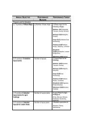
2.5.2 Table 2.1 provides a summary of some major policies and legislation relevant to the<br />
concepts of integrated land use and their impacts on different land use categories. A<br />
notation of the sign (+) denotes that the particular legislation or policy supports the land use<br />
category while the sign (-) denotes possible conflicts or weakness that should be turned into<br />
an opportunity or strength through land use planning.<br />
2.5.3 The Town and Country <strong>Plan</strong>ning Act (Cap. 32:09) established the Town and Country<br />
<strong>Plan</strong>ning <strong>Board</strong> to advise the Minister of <strong>Land</strong>s and Housing on Town and Country <strong>Plan</strong>ning<br />
matters. The Act provides for the declaration of any land in Botswana as a <strong>Plan</strong>ning Area by<br />
the Minister. It mandates the Minister to prepare a Development <strong>Plan</strong> for the area within two<br />
years, and requires that planning permission be sought for development of land in the<br />
16 REPORT OF SURVEY