District Intergrated Land Use Plan - Ngwaketse Land Board
District Intergrated Land Use Plan - Ngwaketse Land Board
District Intergrated Land Use Plan - Ngwaketse Land Board

You also want an ePaper? Increase the reach of your titles
YUMPU automatically turns print PDFs into web optimized ePapers that Google loves.
CHAPTER 1<br />
INTRODUCTION<br />
(iv)<br />
(v)<br />
(vi)<br />
(vii)<br />
The assessment of the existing problems of utilisation of natural resources.<br />
The evaluation of the loss and fragmentation of habitats as a result of development.<br />
The assessment of the impact of the current programmes and policies, as well as<br />
institutional and legal measures and their effectiveness in relation to the sustainable<br />
utilisation of natural resources in the district.<br />
The setting of sustainability objectives and criteria for the district along with the<br />
review of the capacity, potentials and constraints of its natural resource base to<br />
sustain the existing and future development.<br />
(viii) The determination of a long-term strategy best suited to facilitate the realisation of<br />
imum level of benefits from all of the district’s natural resources along with concept<br />
and measures of protection and enhancement of the quality of the district’s<br />
environment, including critical habitats and the areas of high natural value and<br />
cultural heritage.<br />
(ix)<br />
The preparation of a series of maps and accompanying key information showing<br />
receptive capacity and sensitivity of the environment, as well as quantity, quality<br />
and distribution of its component system of resources within the district.<br />
1.6.4 Goal 4: To provide an integrative platform in legislative and administrative sphere for the<br />
effective land use and resource management, monitoring and resolution of conflicting<br />
demands on the use of land. This will be achieved through:<br />
Objectives<br />
(i)<br />
(ii)<br />
(iii)<br />
(iv)<br />
(v)<br />
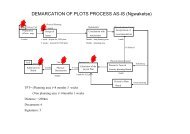
The cadastal survey and registration of plots in primary and secondary centres, and<br />
eventually in tertiary centres, before allocation.<br />
Preparation and updating maps showing plot numbers, street and location names.<br />
Provision of <strong>Land</strong> <strong>Board</strong>s with adequate <strong>Land</strong> Surveyors, Physical <strong>Plan</strong>ners and<br />
<strong>Land</strong>s Officers to provide advice, execute <strong>Land</strong> <strong>Board</strong>s decision, prepare and<br />
update maps.<br />
The preparation of management plans for each of the Sub <strong>Land</strong> <strong>Board</strong> areas and<br />
delegation of all land allocation to Sub <strong>Land</strong> <strong>Board</strong>s where they have been<br />
established, while in such arrangement, the <strong>Land</strong> <strong>Board</strong> will deal with policy,<br />
legislation and appeals from the Sub <strong>Land</strong> <strong>Board</strong>s.<br />
The level of qualifications for <strong>Land</strong> <strong>Board</strong> and Sub <strong>Land</strong> <strong>Board</strong> members be further<br />
increased as land matters are increasingly becoming more complex.<br />
1.6.5 Goal 5: To provide a GIS capability within the <strong>Land</strong> <strong>Board</strong>s, Sub <strong>Land</strong> <strong>Board</strong>s, and DLUPU<br />
in the district. This will be achieved through:<br />
Objectives<br />
(i)<br />
(ii)<br />
The creation of a common GIS data base to provide various GIS applications in<br />
supporting a range of plan preparation and implementation activities.<br />
The use of the GIS as a complete and well-documented system for managing data<br />
and supporting spatial analysis and modeling, especially in environmental zoning,<br />
land capability/sustainability analysis, as well as for execution of the “what if” type of<br />
land use scenario analysis used to examine and evaluate the consequences of<br />
different planning scenarios.<br />
8 REPORT OF SURVEY