District Intergrated Land Use Plan - Ngwaketse Land Board
District Intergrated Land Use Plan - Ngwaketse Land Board
District Intergrated Land Use Plan - Ngwaketse Land Board

Create successful ePaper yourself
Turn your PDF publications into a flip-book with our unique Google optimized e-Paper software.
CHAPTER 1<br />
INTRODUCTION<br />
1.1.4 It is evidently clear that the Government is sensitive to the situation and the concern is well<br />
founded. Without doubt, the intention of Government is to address the land use problems<br />
and issues discernible in the district. It is against this backdrop that the Government<br />
commissioned Environmetrix Proprietary Limited to prepare an Integrated <strong>Land</strong> <strong>Use</strong> <strong>Plan</strong><br />
for Southern <strong>District</strong>. The Southern <strong>District</strong> Integrated <strong>Land</strong> <strong>Use</strong> <strong>Plan</strong> (SDILUP) is expected<br />
to provide guidance on what land use activities should take place and where, in a<br />
sustainable manner in the <strong>District</strong>.<br />
1.2 LOCATION AND SIZE<br />
1.2.1 The Southern <strong>District</strong> is located in the South Eastern <strong>Plan</strong>ning Region (SEPR) of Botswana,<br />
between latitudes 23 and 29 degrees South of the Equator and between 23 and 29 degrees<br />
East of Greenwich Meridian. The <strong>Plan</strong> Area is bordered to the north by Kweneng <strong>District</strong>; to<br />
the east by South East <strong>District</strong>; to the south by the Republic of South Africa (RSA); and<br />
Kgalagadi <strong>District</strong> to the west. (See Map 1.1). With a land mass of 26 776 km 2 it is the<br />
sixth largest district in Botswana and the second largest in SEPR.<br />
1.2.2 In 1981, a total of 119 653 people resided in the district. A decade later, the population<br />
increased to 147 389 people. The 2001 Population and Housing Census revealed that a<br />
total of 171 652 people resided in the plan area. Correspondingly, population density<br />
increased from 4.5 person per km 2 in 1981 to 5.5 and 6.4 persons per km 2 in 1991 and<br />
2001 respectively. It is important to note, that the <strong>District</strong>’s national share of population<br />
declined from 12.7 percent in 1981 to 11.1 percent and 10.2 percent in 1991 and 2001<br />
respectively. While the various districts of Gaborone, Kweneng and South East that are in<br />
close proximity to Southern <strong>District</strong> have shown an increase in the national share of<br />
population, the converse is the case with the Southern <strong>District</strong>. The situation is easily<br />
attributable to the decline in the attractiveness of the <strong>District</strong>.<br />
1.2.3 There are two major centres in the <strong>District</strong> namely: Kanye and Moshupa. Kanye is the<br />
administrative headquarters of the district. Currently, there exist two sub-districts, namely:<br />
Mabutsane and Good Hope in the <strong>District</strong>. However, the South Eastern Region Master<br />
<strong>Plan</strong> (SERMP) proposes two additional sub-districts of Moshupa and Maokane.<br />
1.3 STATUTORY AND POLICY PROVISIONS<br />
1.3.1 The legislation that underpins the land use plan is the Tribal <strong>Land</strong> Act amended in 1993.<br />
The amendment in the Act is designed to create a statutory framework for the preparation<br />
and adoption of the land use plan for the <strong>District</strong>.<br />
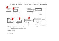
1.3.2 Section 17 of the Tribal <strong>Land</strong> Act as amended in 1993 provides in subsection (1) that “A<br />
land board shall, after due consultation with the district council, determine and define land<br />
use zoning within the tribal areas, and may from time to time make amendments thereto”.<br />
1.3.3 Section 17(2), require the <strong>Land</strong> <strong>Board</strong> to furnish the Minister with details of all<br />
determinations, definitions or amendments made under subsection (1). In addition, section<br />
17(2) also provides that if the Minister is satisfied with the descriptions of the land<br />
concerned and that the land use zoning is in accordance with section 37 in respect of which<br />
the types of land use for which land may be zoned, he shall give notice thereof in the<br />
gazette. Specifically, section 17(3) provides that “The land board shall not make grants of<br />
land under this part for any land use which is in conflict with the use for which the land is<br />
zoned”<br />
2 REPORT OF SURVEY