C212 Port Lamont to Ardtaraig Loch Striven.pdf - Argyll and Bute ...
C212 Port Lamont to Ardtaraig Loch Striven.pdf - Argyll and Bute ...
C212 Port Lamont to Ardtaraig Loch Striven.pdf - Argyll and Bute ...

Create successful ePaper yourself
Turn your PDF publications into a flip-book with our unique Google optimized e-Paper software.
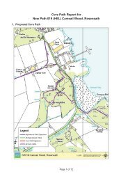
1. Proposed Core Path<br />
Core Path Report for <strong>C212</strong><br />
<strong>Port</strong> <strong>Lamont</strong> <strong>to</strong> <strong>Ardtaraig</strong>, <strong>Loch</strong> <strong>Striven</strong><br />
Page 1 of 37
2. Summary of Representations Received<br />
Representation<br />
Objection<br />
Support<br />
Respondent<br />
Name<br />
Michael<br />
Laing<br />
Nicholas<br />
Halls<br />
Organisation/<br />
Group<br />
Strutt & Parker<br />
on behalf of<br />
Glenstriven<br />
Estate<br />
Representative<br />
of<br />
Mountaineering<br />
Support Frieda Bos About <strong>Argyll</strong><br />
Walking<br />
Holidays<br />
Support Ben<br />
Mitchell<br />
Objection<br />
Summery<br />
Irresponsible<br />
Access /<br />
Business /<br />
Maintenance<br />
Respondents<br />
proposed<br />
action<br />
Delete<br />
Respondent<br />
Ref No.<br />
P028<br />
P069<br />
P166<br />
E068<br />
Objection<br />
withdrawn<br />
3. His<strong>to</strong>ry of Access<br />
i. Right of Way Status – ROW SA36 see Appendix IV<br />
ii. Recorded Access Issues: The ScotWays report notes that a succession of l<strong>and</strong> owners<br />
have sought <strong>to</strong> deter public access or discourage use of the route. Previous owners of<br />
Glenstriven Estate have been unhappy that there is a sign at the southern end which<br />
encouraged use of the route which they considered dangerous.<br />
4. Site Visit<br />
Pho<strong>to</strong>graphs of the path <strong>and</strong> surroundings with comments<br />
ScotWays sign on the B836 indicating<br />
path <strong>to</strong> Glenstriven<br />
Start of the path on <strong>to</strong> <strong>Ardtaraig</strong> Estate<br />
Path descending <strong>to</strong> the Glentarsan Burn<br />
The path turns <strong>to</strong> the left just before the<br />
barn with the green doors <strong>and</strong> does not<br />
get any closer <strong>to</strong> <strong>Ardtaraig</strong> House.<br />
Page 2 of 37
Better signs could reduce the likelihood of<br />
people walking past the house<br />
Route <strong>to</strong> the east of the buildings<br />
Path <strong>to</strong> the south of the main house<br />
following estate track<br />
Path past Boathouse Cottages note well<br />
defined gardens<br />
View north along the path past the<br />
slipway for the Mussel Farm<br />
Gate <strong>and</strong> stile at entry <strong>to</strong> the woodl<strong>and</strong>s<br />
Pheasant release pens beside the path<br />
Path deteriorates as it leaves the estate<br />
road just before a house called “Tigh Na<br />
Mara” <strong>and</strong> continues <strong>to</strong> be rough going<br />
for 3km<br />
Page 3 of 37
The path deteriorates <strong>and</strong> at the time of<br />
the site visit at the end of a period of wet<br />
weather was very wet in places<br />
Path sign <strong>and</strong> gate at the boundary of the<br />
native woodl<strong>and</strong> area<br />
Old gate in the dyke<br />
The path is visible on the ground but can<br />
be rough going in many areas<br />
The route often follows a terrace on the<br />
hillside which may be quite ancient<br />
Fallen trees need <strong>to</strong> be cleared<br />
The path climbs in some places giving<br />
occasional views of the loch<br />
Several streams have <strong>to</strong> be forded<br />
Page 4 of 37
The path can be indistinct in places, way<br />
marking could assist users significantly<br />
The ab<strong>and</strong>oned farmstead at Bot nan<br />
Creagan adds interest <strong>to</strong> the route<br />
Spectacular view <strong>to</strong>wards the Kyles of<br />
<strong>Bute</strong> from Bot nan Creagan<br />
View north along <strong>Loch</strong> <strong>Striven</strong>, used<br />
during WWII <strong>to</strong> test Bouncing Bombs<br />
Boundary with Glenstriven Estate<br />
500metres from the estate road<br />
Junction of the path with the estate track<br />
Note pheasant feeders beside the track<br />
which is used <strong>to</strong> manage a very high<br />
density of Pheasants<br />
Track leading off <strong>to</strong> “The Point” an estate<br />
cottage<br />
Page 5 of 37
Estate track through Glenstriven Estate<br />
View of Invervegan house from the path<br />
View of Burnfoot Cottage from the track<br />
Highfield Cottage a holiday cottage on the<br />
estate from the path 100metres away<br />
View of Pier House a holiday cottage<br />
beside the path (See Appendix IV)<br />
Approach <strong>to</strong> Glenstriven Lodge<br />
Glenstriven Lodge<br />
Junction between the estate road <strong>and</strong> the<br />
public road<br />
Page 6 of 37
Section of this path on the public road<br />
looking north<br />
5. Alternative Route/s<br />
The existing path occupies part of a narrow strip of l<strong>and</strong> between <strong>Loch</strong> <strong>Striven</strong> <strong>and</strong> the high hills which<br />
rise <strong>to</strong> around 500 metres immediately <strong>to</strong> the east. Therefore there is no scope for the provision of an<br />
alternative route.<br />
6. Consultation with Objec<strong>to</strong>rs & Other Interested Parties<br />
The finalised plan is sufficient without the inclusion of non core paths generally <strong>and</strong> specifically within<br />
Glen <strong>Striven</strong> Estate.<br />
The inclusion of non core paths imposes liabilities <strong>and</strong> restrictions on the owners of the l<strong>and</strong> which<br />
were not within the contemplation of the Act<br />
In this instance our client has expended significant sums of money creating <strong>and</strong> improving path <strong>and</strong><br />
tracks for estate management purposes.<br />
As non core paths there is no guarantee that these paths are routes over which the public would be<br />
entitled <strong>to</strong> take access, that the routes currently exist or will be maintained or available for use by the<br />
public <strong>and</strong> accordingly the inclusion of such routes is likely <strong>to</strong> mislead <strong>and</strong> potentially endanger the<br />
public as well as having detrimental effects for our client.<br />
During a discussion with the Head Keeper during the site visit raised a number of issues. These<br />
included disturbance of wildlife in the area, the use of the southern part of the track for feeding<br />
pheasants <strong>and</strong> other game birds <strong>and</strong> the presence of release pens close <strong>to</strong> the route. He also<br />
reported that at least one walker has become seriously lost whilst using the route <strong>and</strong> only found his<br />
way <strong>to</strong> the keeper’s house in the early hours of the morning.<br />
7. Access Officer’s Initial Comments<br />
<strong>C212</strong> is a claimed Right of Way <strong>and</strong> recorded by ScotWays as a Heritage Path known as “Old road<br />
along <strong>Loch</strong> <strong>Striven</strong>” <strong>and</strong> is described as a very old packhorse <strong>and</strong> possibly cart track that passes<br />
ruined settlements. See Appendix IV for more information on this Heritage Path. In the same<br />
appendix there is a copy from the pages of “25 Walks Arrochar, Cowal <strong>and</strong> <strong>Bute</strong>” which describes<br />
this walk.<br />
One supporter of the route has pointed out that a bus service (482) runs between <strong>Port</strong> <strong>Lamont</strong> (the<br />
southern end of <strong>C212</strong>) <strong>and</strong> Dunoon. There is another bus service (477/478/479) on the B836 (the<br />
northern end of <strong>C212</strong>) that runs between Dunoon <strong>and</strong> <strong>Port</strong>avadie making the route accessible by<br />
public transport at both ends which is uncommon in <strong>Argyll</strong> & <strong>Bute</strong>.<br />
A substantial part of the path is in a poor condition but it is of his<strong>to</strong>rical interest <strong>and</strong> offers good views<br />
over <strong>Loch</strong> <strong>Striven</strong> <strong>and</strong> the Kyles of <strong>Bute</strong>. The Royal Commission on the Ancient <strong>and</strong> His<strong>to</strong>rical<br />
Page 7 of 37
Monuments of Scotl<strong>and</strong> includes information on a number of sites including ab<strong>and</strong>oned settlements,<br />
farms <strong>and</strong> st<strong>and</strong>ing s<strong>to</strong>nes along this path on their website www.canmoremapping.rcahms.gov.uk.<br />
<strong>Loch</strong> <strong>Striven</strong> itself was used <strong>to</strong> test a version of the Barnes Wallis “bouncing bomb” during the Second<br />
World War. The path passes through an area of attractive semi natural woodl<strong>and</strong> <strong>and</strong> despite being a<br />
difficult walk, many of those who have walked the path report having enjoyed it.<br />
The path has a <strong>to</strong>tal length of fourteen kilometres. The northern section of four kilometres is on<br />
<strong>Ardtaraig</strong> Estate, then a further three <strong>and</strong> a half kilometres <strong>to</strong> the south is on Glenstriven Estate <strong>and</strong><br />
the subject of an Objection. The remaining seven kilometres is on the public road between Glenstriven<br />
Estate <strong>and</strong> <strong>Port</strong> <strong>Lamont</strong>.<br />
The first kilometre on <strong>Ardtaraig</strong> Estate is on well maintained estate tracks, apart from a poor surface on<br />
one of the steeper slopes. After passing the house called Tigh Na Mara the path is in a poor condition<br />
for three kilometres until it joins estate road on Glenstriven Estate. Only the last five hundred meters of<br />
this section of poor path is on Glenstriven Estate. It may be difficult <strong>to</strong> follow particularly in summer<br />
when bracken will obstruct the route <strong>and</strong> in many areas the path is rough <strong>and</strong> poorly drained. However<br />
in most places it is still apparent that there was once a track or a minor road linking some isolated<br />
farms or settlements along the route. In one or two locations it is still possible <strong>to</strong> see that the path was<br />
constructed with s<strong>to</strong>ne along one edge of the path <strong>and</strong> that there were once culverts in some areas<br />
although most of the streams are crossed at fords.<br />
The bulk of the path on Glenstriven Estate follows the main estate track for just under 3 kilometres <strong>and</strong><br />
is in excellent condition. This part of the estate is intensively used for pheasant rearing <strong>and</strong> there are<br />
numerous feeders along the path <strong>and</strong> there are release pens in the adjacent woodl<strong>and</strong>s. Glenstriven<br />
estate derives a substantial part of its income from shooting <strong>and</strong> the main house is marketed <strong>to</strong><br />
shooting parties. It is interesting <strong>to</strong> note that <strong>Ardtaraig</strong> Estate has not objected <strong>to</strong> the designation of<br />
this path although it is also managed for shooting <strong>and</strong> there are two release pens beside the path.<br />
The following are responses <strong>to</strong> the objec<strong>to</strong>r’s case.<br />
Sufficiency: The Access Officers are of the view that without the inclusion of this path the Core Path<br />
Network will be insufficient in this part of the Cowal. This is the only long low level path giving access<br />
<strong>to</strong> areas of semi-natural woodl<strong>and</strong> in an extensive area of wild l<strong>and</strong>. The <strong>Argyll</strong> & <strong>Bute</strong> Access Forum<br />
has a statu<strong>to</strong>ry role <strong>to</strong> advise the Council on access rights <strong>and</strong> the sufficiency of the Core Paths Plan.<br />
Designating Core Paths: The Local Authority has a duty under Section 17 of the L<strong>and</strong> Reform<br />
(Scotl<strong>and</strong>) Act 2003 <strong>to</strong> designate a network of Core Paths which may include any path whether or not it<br />
is a Public Right of Way. Since this is the first time that this Authority has produced a Core Paths Plan<br />
it would not be possible <strong>to</strong> designate paths that are already Core Paths since there are none. Any<br />
Objec<strong>to</strong>r <strong>to</strong> an element of the Core Paths Plan has a right <strong>to</strong> have their objection considered by a<br />
Reporter acting on behalf of the Scottish Ministers, it is anticipated that this objection will be considered<br />
in this manner.<br />
Liability - The L<strong>and</strong> Reform Scotl<strong>and</strong> Act does not extend the duty of care owed by the l<strong>and</strong> manager/<br />
l<strong>and</strong> owner <strong>to</strong> another person exercising their access rights. The Scottish Outdoor Access Code <strong>and</strong><br />
the Act also stress that the access taker is responsible for their own safety. The L<strong>and</strong> Reform Scotl<strong>and</strong><br />
Act “establishes statu<strong>to</strong>ry public rights of access <strong>to</strong> l<strong>and</strong> for recreational purposes” <strong>and</strong> imposes some<br />
duties <strong>and</strong> responsibilities on l<strong>and</strong> owners <strong>and</strong> managers.<br />
Page 8 of 37
Creation of new tracks <strong>and</strong> paths; The majority of the l<strong>and</strong> on this estate will fall within Access<br />
Rights under the L<strong>and</strong> Reform Scotl<strong>and</strong> Act. By creating new tracks <strong>and</strong> paths the l<strong>and</strong> owner is<br />
simply making it easier for people <strong>to</strong> explore the area <strong>and</strong> exercise their access rights than would be<br />
the case in the absence of the paths.<br />
Access Rights; One reason that this path is being proposed as a Core Path is that it is considered <strong>to</strong><br />
be a Public Right of Way by the Scottish Rights of Way Society. Neither a Core Path nor for that<br />
matter a Public Right of Way has <strong>to</strong> pass exclusively through areas where access rights can be<br />
exercised. The majority of the route in my opinion passes through areas where there are public rights<br />
of access. Only two properties are so close <strong>to</strong> the proposed Core Path that I would consider it as<br />
having a significant impact upon the privacy of the occupants.<br />
Privacy<br />
The Point; This cottage at right is located over 50<br />
metres off the path <strong>and</strong> at such a distance the<br />
impact on privacy is considered reasonable.<br />
Burnfoot Cottage – This is only four or five<br />
metres off the path but is well screened by the<br />
trees <strong>and</strong> shrubs around it. The character of this<br />
cottage is such that it is close <strong>to</strong> an existing track<br />
serving a large estate <strong>and</strong> the path is unlikely <strong>to</strong><br />
significantly disturb the enjoyment of the house.<br />
Invervegan House at left, although a much larger<br />
property it is over 60 metres off the path <strong>and</strong> is<br />
only visible from a distance because it is located<br />
on a rise several metres above the path. Again the<br />
impact of the path on the privacy of the occupants<br />
is not unreasonable.<br />
Page 9 of 37
Glenstriven Lodge; This is a lodge house beside<br />
the path <strong>and</strong> is designed <strong>to</strong> overlook the entrance<br />
<strong>to</strong> the estate. As a consequence this is the house<br />
which will be most disturbed by people using the<br />
path. The estate road at this point serves<br />
Pier Cottage; at left, this house is immediately<br />
beside <strong>and</strong> below the path which serves the estate<br />
<strong>and</strong> at least four other houses beyond it. The house<br />
is currently used as a holiday let, see appendix IV.<br />
Although close <strong>to</strong> the track anyone passing the house<br />
will only be visible for a minute or two as they pass.<br />
The main views from the house are of the loch on the<br />
opposite side of the property. Although there is likely<br />
<strong>to</strong> be a small reduction in the privacy enjoyed by this<br />
property it not considered <strong>to</strong> be significant. It should<br />
be remembered that a Core Path can be designated<br />
in an area where access rights do not apply.<br />
Damage <strong>to</strong> the Track – It is unlikely that walkers or cyclists would cause significant damage <strong>to</strong> the<br />
track in comparison with cars <strong>and</strong> agricultural vehicles. Equestrian users could cause some damage<br />
however this is likely <strong>to</strong> be less than the existing vehicular use. In this case the path may be used<br />
along its whole length by walkers; however cyclists <strong>and</strong> horse riders would be restricted <strong>to</strong> those<br />
sections on the public road or estate track by the poor condition of the path.<br />
Impact on L<strong>and</strong> Management; The designation of the Core Path should make it easier for the estate<br />
<strong>to</strong> inform the public about l<strong>and</strong> management operations including shooting i.e. by erecting signs at the<br />
lodge house. This is because it will be much clearer where most members of the public are likely <strong>to</strong><br />
enter <strong>and</strong> leave an area. The Access Authority has already produced signs that are used by l<strong>and</strong><br />
managers elsewhere <strong>to</strong> direct the public when shooting is happening.<br />
Access Issues; There has been at least one instance where a member of the public reported being<br />
deterred from using the proposed Core Path . The path has been considered a Public Right of Way by<br />
the Scottish Rights of Way Society since 1948 when the then l<strong>and</strong> owner gave permission for the<br />
erection of direction signs, one of which has since disappeared.<br />
Summary; In summary there would appear <strong>to</strong> have been an ongoing issue with a succession of the<br />
owners of Glenstriven Estate , which is advertised for sale at present (December 2011) trying <strong>to</strong> deter<br />
or block public access along this path. Although the path is not in a good condition for a significant<br />
portion of its length, if this path is not designated <strong>and</strong> the additional powers that this will give the<br />
Access Authority <strong>to</strong> moni<strong>to</strong>r the path <strong>and</strong> ensure that it remains available <strong>to</strong> the public it may be lost. It<br />
may also be increasingly difficult for the Access Authority <strong>to</strong> assert <strong>and</strong> protect public rights of access<br />
without resorting <strong>to</strong> expensive <strong>and</strong> risky legal action.<br />
The path is already promoted in at least one guidebook, on one website <strong>and</strong> is sign posted at one end.<br />
Page 10 of 37
Designating this path as a Core Path will enable the Council, the local community or the l<strong>and</strong> owner <strong>to</strong><br />
begin <strong>to</strong> improve this route. Even a simple action such as installing way markers along the poorest<br />
sections of the path will make it less likely that the user will get lost. Additional work such as removing<br />
fallen branches could be undertaken by volunteers <strong>and</strong> repairs <strong>to</strong> the drainage would soon make<br />
following this path much easier. The intention would not be <strong>to</strong> make a major improvement <strong>to</strong> this path<br />
because of its setting <strong>and</strong> his<strong>to</strong>rical interest.<br />
Therefore I am recommending that this path is included in the Core Paths Plan <strong>to</strong> ensure that it<br />
continues <strong>to</strong> be available for walkers <strong>and</strong> <strong>to</strong> ensure that a sufficient network of Core Paths is provided<br />
in this area of the Cowal Peninsula.<br />
Page 11 of 37
8. Advice received from the Access Forum<br />
<strong>Argyll</strong> <strong>and</strong> <strong>Bute</strong> Council Core Path Plan<br />
Finalised Draft 2012<br />
Minute of Discussions by the Access Forum<br />
Path Number: <strong>C212</strong><br />
Path Name: <strong>Port</strong> <strong>Lamont</strong> <strong>to</strong> <strong>Ardtaraig</strong>, <strong>Loch</strong> <strong>Striven</strong><br />
Forum Members Present<br />
John Urquhart (Chair)<br />
John Little<br />
Niall McAlister Hall (Vice Chair)<br />
Duncan McDonald<br />
Fiona Russell<br />
Stuart Shaw<br />
Declarations of Interest<br />
None<br />
Members Familiar with the Location<br />
None<br />
Discussions<br />
Part of the route forms a claimed right of way <strong>and</strong> is recorded as a Heritage Path<br />
Access Issues<br />
Privacy<br />
Condition of the path<br />
Management of the estates sporting interests, Ardtarig <strong>to</strong> the north has pheasant release<br />
pens adjacent <strong>to</strong> the path <strong>and</strong> has not expressed concern whilst Glenstriven Estate has<br />
lodged an objection<br />
Level of use<br />
Path passes through two estates – are they both aware of proposal?<br />
Access Forum Advice <strong>to</strong> <strong>Argyll</strong> <strong>and</strong> <strong>Bute</strong> Council<br />
Support Officer’s Recommendation (in Section 7)<br />
Object <strong>to</strong> Officer’s Recommendation (in Section 7)<br />
Mixed opinion amongst Access Forum members (record all views below)<br />
Majority View<br />
Unanimous support that this become a core path with the following caveats:<br />
Council can confirm <strong>Ardtaraig</strong> estate are aware of proposal<br />
The privacy of Glenstriven Lodge needs <strong>to</strong> be considered. The original Right Of Way<br />
follows a different route passed Glenstriven Lodge <strong>and</strong> there may be a requirement for the<br />
Core Path <strong>to</strong> follow that route rather than the route currently shown. This amendment will<br />
require funding <strong>to</strong> be identified as the original route is in poor condition <strong>and</strong> overgrown.<br />
The Council will develop signage <strong>to</strong> help manage access <strong>and</strong> estates sporting interests.<br />
Minority View<br />
Page 12 of 37
9. Access Officer’s Final Recommendations<br />
It is recommended that this path continues <strong>to</strong> be proposed as a Core Path because of it is a popular<br />
route which has a long his<strong>to</strong>ry of public use <strong>and</strong> is recognised as a Public Right of Way. The route<br />
identified is the most practical since the former route along the shore has fallen in<strong>to</strong> disrepair.<br />
Page 13 of 37
10. Appendices<br />
Appendix I.<br />
Copies of the representations received during the formal consultation<br />
Page 14 of 37
Page 15 of 37
Page 16 of 37
Page 17 of 37
Page 18 of 37
Page 19 of 37
Paragraph 11.5.11 from 2010 Core Paths Plan Finalised Draft document<br />
11.5.11<br />
Core Path No. <strong>C212</strong> - <strong>Port</strong> <strong>Lamont</strong> To Ardtariag, <strong>Loch</strong> <strong>Striven</strong><br />
Path length in meters - 14703<br />
Surface Types - Sealed, unbound aggregate, trod earth<br />
Gradient - Steep<br />
Sign Posts - Yes<br />
Bridges - No<br />
Gates less than 1.2 meters - None<br />
Kissing Gates - None<br />
Stiles - None<br />
Other Information - Gates>1.2m<br />
Potential obstacles <strong>and</strong> notes - Sections on public road<br />
Appendix II.<br />
None<br />
Copies of relevant correspondence<br />
Page 20 of 37
Appendix III.<br />
Copies of responses additional consultations<br />
From: jjbryson@waitrose.com [mail<strong>to</strong>:jjbryson@waitrose.com]<br />
Sent: 02 July 2012 17:06<br />
To: Garner, David<br />
Subject: Re: Core path objection report comments<br />
I am now away on holiday.<br />
Please record that SCCC supports the <strong>Loch</strong> <strong>Striven</strong> path proposal.<br />
Page 21 of 37
<strong>Argyll</strong> <strong>and</strong> <strong>Bute</strong> Council Core Paths Plan<br />
Finalised Draft 2012<br />
Objection Report Representation<br />
Path or Launch Point No. & Name: <strong>C212</strong> <strong>Port</strong> <strong>Lamont</strong> <strong>to</strong> <strong>Ardtaraig</strong>, <strong>Loch</strong> <strong>Striven</strong><br />
Comment Only (In A Number Of Cases The Access Officers Have Not Made A Recommendation;<br />
Please Use This Option To Make Your Views Known)<br />
Comment: This is a great walk <strong>and</strong> not <strong>to</strong> difficult. This allowing many people <strong>to</strong> enjoy a great walk<br />
along he shore of <strong>Loch</strong> <strong>Striven</strong>. This is a great walk <strong>and</strong> should be developed <strong>and</strong> used as a sales aid<br />
fot the district of Dunoon <strong>and</strong> <strong>Argyll</strong> n <strong>Bute</strong><br />
Your name: Walt Foster<br />
Serial No. 52<br />
Email address: waltfos@hotmail.com<br />
Address & Phone:<br />
<strong>Argyll</strong> <strong>and</strong> <strong>Bute</strong> Council Core Paths Plan<br />
Finalised Draft 2012<br />
Objection Report Representation<br />
Path or Launch Point No. & Name: <strong>C212</strong> <strong>Port</strong> <strong>Lamont</strong> <strong>to</strong> <strong>Ardtaraig</strong>, <strong>Loch</strong> <strong>Striven</strong>A.<strong>pdf</strong><br />
Support Officer's Recommendation<br />
Comment: This path is one of the few his<strong>to</strong>rical rights of way in Cowal. It is the only means of access<br />
between the two elements of <strong>Loch</strong> <strong>Striven</strong> without a lengthy de<strong>to</strong>ur. Once lost this route will be lost for<br />
ever. It has potential for <strong>to</strong>urism <strong>and</strong> will form part of the proposed East Cowal Way. Just because it is<br />
inconveniant for the pheasant shooters is not sufficient reason <strong>to</strong> close the route. Estate houses can<br />
easily be by passed. Just because parts of the path have been lost or re-routed is not reason <strong>to</strong> lose<br />
the route for the public. Effective signage <strong>and</strong> good liaison should allow pheasants <strong>and</strong> walkers <strong>to</strong> coexist.<br />
Andrew Armstrong<br />
Your name: Andrew Armstrong<br />
Serial No. 56<br />
Email address: armstrong<strong>and</strong>y@btinternet.com<br />
Address & Phone:<br />
4 Ash Gardens Kirn Dunoon PA23 8DH Tel 01369 704617<br />
Page 22 of 37
<strong>Argyll</strong> <strong>and</strong> <strong>Bute</strong> Council Core Paths Plan<br />
Finalised Draft 2012<br />
Objection Report Representation<br />
Path or Launch Point No. & Name: <strong>C212</strong> <strong>Port</strong> <strong>Lamont</strong> <strong>to</strong> <strong>Ardtaraig</strong>, <strong>Loch</strong> <strong>Striven</strong>A.<strong>pdf</strong><br />
Support Officer's Recommendation<br />
Comment: I have walked this area as a linear route. Although there is a public right of way, it was<br />
noted that signage was limited <strong>and</strong> the footpath not always clear, inspite of it being shown on OS maps<br />
- as if not encouraging access. Viewing the wonderful flora <strong>and</strong> fauna in this area should be<br />
encouraged, with information <strong>and</strong> guidance for people <strong>to</strong> underst<strong>and</strong> <strong>and</strong> respect this part of the world,<br />
particularly those in the local community.<br />
Your name: Moira Ferguson<br />
Serial No. 61<br />
Email address:<br />
Address & Phone:<br />
Aldersyde, Shore Road, Kilmun, Dunoon. <strong>Argyll</strong>. Pa23 8se<br />
Tel: 07711 039 528<br />
<strong>Argyll</strong> <strong>and</strong> <strong>Bute</strong> Council Core Paths Plan<br />
Finalised Draft 2012<br />
Objection Report Representation<br />
Path or Launch Point No. & Name: <strong>C212</strong> <strong>Port</strong> <strong>Lamont</strong> <strong>to</strong> <strong>Ardtaraig</strong>, <strong>Loch</strong><br />
<strong>Striven</strong>A.<strong>pdf</strong><br />
Support Officer's Recommendation<br />
Comment: A good core path linking the <strong>to</strong>p <strong>and</strong> bot<strong>to</strong>m of <strong>Loch</strong> <strong>Striven</strong><br />
Your name: Jean Maskell<br />
Serial No. 63<br />
Email address: jmargyll@gmail.com<br />
Address & Phone:<br />
Dalinlongart Farmhouse, S<strong>and</strong>bank Dunoon Pa23 8qs 01369 704955<br />
Page 23 of 37
<strong>Argyll</strong> <strong>and</strong> <strong>Bute</strong> Council Core Paths Plan<br />
Finalised Draft 2012<br />
Objection Report Representation<br />
Path or Launch Point No. & Name: <strong>C212</strong> <strong>Port</strong> <strong>Lamont</strong> <strong>to</strong> <strong>Ardtaraig</strong>, <strong>Loch</strong> <strong>Striven</strong>A.<strong>pdf</strong><br />
Support Officer's Recommendation<br />
Comment: I have been with a group who recently walked this path. I underst<strong>and</strong> it <strong>to</strong> be an ancient<br />
pack-horse route <strong>and</strong> of considerable his<strong>to</strong>rical interest. It is also a place showing some beautiful flora<br />
<strong>and</strong> fauna. The Cowal area is limited in the number of relatively flat walks it can offer. This is one <strong>and</strong>,<br />
as I underst<strong>and</strong>, has been a Scottish right of way for over sixty years. As such it is a shame that there<br />
is, in places, poor or no signage. This does not encourage walkers <strong>to</strong> keep <strong>to</strong> a designated route,<br />
particularly when some areas are in poor condition.A rare benefit of this right of way is <strong>to</strong> have public<br />
transport available at either end of the route.<br />
Your name: Moira Ferguson<br />
Serial No. 87<br />
Email address: moiraclinch@hotmail.com<br />
Address & Phone: Aldersyde, Shore Rd. Kilmun, <strong>Argyll</strong>. Pa23 8se<br />
Tel: 07711 039 528<br />
<strong>Argyll</strong> <strong>and</strong> <strong>Bute</strong> Council Core Paths Plan<br />
Finalised Draft 2012<br />
Objection Report Representation<br />
Path or Launch Point No. & Name: <strong>C212</strong> <strong>Port</strong> <strong>Lamont</strong> <strong>to</strong> <strong>Ardtaraig</strong>, <strong>Loch</strong><br />
<strong>Striven</strong>A.<strong>pdf</strong><br />
Support Officer's Recommendation<br />
Comment: This is a critical path - the only path up the east of <strong>Loch</strong> <strong>Striven</strong>. we are hoping <strong>to</strong><br />
itroduce an East Cowal Coastal Path from Arrochar <strong>to</strong> Ardtariag. This would be the final <strong>and</strong> most<br />
remote section. The East Cowal Paths group had a walk here in May which was one of the most<br />
popular walks we have initiated. We <strong>to</strong>tally support the comments of the Access officer. The path<br />
does not enter the curtildge of any property. It does not interfere with any forestry workings. It does<br />
not disturb game or interefere with breeding birds.<br />
Your name: East Cowal Paths Group - Dinah Mcdonald<br />
Serial No. 115<br />
Email address: dinah.mcdonald@btinternet.com<br />
Address & Phone: 6 Deer Park, Glen Massan, Dunoon Pa23 8ra<br />
01369 706591<br />
Page 24 of 37
From: Bill Carlow [mail<strong>to</strong>:bill@matata.demon.co.uk]<br />
Sent: 23 January 2013 09:34<br />
To: Grierson, Douglas; rorie@colesmoorfarm.co.uk; dcw@farming.me.uk; marcusgeddes@googlemail.com;<br />
nicola@haggarts.com<br />
Subject: Re: core path report<br />
Dear Douglas,<br />
Thank you for your consideration in drawing <strong>C212</strong> Core Path <strong>to</strong> the attention of the Trustees of<br />
<strong>Ardtaraig</strong> Estate, <strong>and</strong> for the considerable work you have done in drawing up the proposal.<br />
This Footpath has been the access for the Northern inhabitants of <strong>Loch</strong> <strong>Striven</strong> <strong>to</strong> their Parish Church<br />
at Inverchaolin since records began. The Estate views its inclusion as a Core Path as a positive step<br />
in formalising its route <strong>and</strong> as such is in favour of its inclusion.<br />
Kind regards,<br />
Bill Carlow<br />
----- Original Message -----<br />
From: Grierson, Douglas<br />
To: 'bill@matata.demon.co.uk' ; 'rorie@colesmoorfarm.co.uk' ; 'dcw@farming.me.uk' ;<br />
'marcusgeddes@googlemail.com' ; 'nicola@haggarts.com'<br />
Sent: Friday, January 18, 2013 3:07 PM<br />
Subject: core path report<br />
Dear Trustees of <strong>Ardtaraig</strong> Estate,<br />
I have been asked by members of the <strong>Argyll</strong> <strong>and</strong> <strong>Bute</strong> Local Access Forum (LAF)<strong>to</strong> check that you are aware<br />
of the proposed Core Path Report <strong>C212</strong> <strong>Port</strong> <strong>Lamont</strong> <strong>to</strong> <strong>Ardtaraig</strong>, <strong>Loch</strong> <strong>Striven</strong> <strong>and</strong> its associated report.<br />
I previously contacted you, at the request of Mr Carlow with regards <strong>to</strong> the report for Aspirational Path A020<br />
<strong>and</strong> its proposed amendment, however as no comment was received from <strong>Ardtaraig</strong> Estate regarding the<br />
proposed core path <strong>C212</strong> the LAF wished it confirmed the Estate were aware of this proposal.<br />
If you wish <strong>to</strong> respond <strong>to</strong> this email I would be grateful if you could please do so before the 4 th of February<br />
2013.<br />
Yours sincerely,<br />
Douglas Grierson<br />
Page 25 of 37
Appendix IV. Additional supporting documents<br />
Copy of the Scottish Rights of Way <strong>and</strong> Access Society’s Catalogue of Public Rights<br />
of Way entry regarding this path<br />
Page 26 of 37
Page 27 of 37
Email correspondence from Scotways<br />
From: Eleisha Fahy [mail<strong>to</strong>:eleisha_fahy@scotways.com]<br />
Sent: 08 August 2012 15:34<br />
To: Grierson, Douglas<br />
Subject: RE: Claimed Right of Way SA36 at Glenstriven<br />
Hello Douglas,<br />
Sorry <strong>to</strong> take so long <strong>to</strong> investigate this enquiry. However, i’ve now managed <strong>to</strong> discuss the route with both<br />
Neil Ramsay (Heritage Paths) <strong>and</strong> our former field officer Alistair Lawson, along with consulting the records<br />
we have for our Scottish Hill Tracks books, so I’m hoping I can be helpful even after such a delay.<br />
We agree with you that your dashed black line is the correct line of right of way SA36. Our recorded line (in<br />
orange) is likely be a red herring in this case as we know this line <strong>to</strong> be poorly mapped even at 1:50,000. We<br />
had, for a number of years, a signpost pointing along the shore route, but this has been reported as missing.<br />
Proving a deviation of the route may prove difficult – it would involve distributing questionnaires <strong>and</strong> the<br />
evidence received would have <strong>to</strong> show that this alternative route had been used for 20 years. If the shore line<br />
route hasn’t fallen out of use completely, then we’d be looking at two rights of way!<br />
I agree that the practical route at present appears <strong>to</strong> be past the Lodge House, but unfortunately we don’t<br />
currently appear <strong>to</strong> have evidence of its use as of right. Is there anything that can be done <strong>to</strong> improve the<br />
shore route?<br />
Let me know if you need me <strong>to</strong> see if I can dig out anything further on this. I’m out of the office now until next<br />
week, but I’d also be happy <strong>to</strong> discuss it, if you’d like <strong>to</strong> call.<br />
Kind regards,<br />
Eleisha<br />
Eleisha Fahy<br />
Access Enquiries<br />
Scottish Rights of Way <strong>and</strong> Access Society (ScotWays)<br />
24 Ann<strong>and</strong>ale Street, Edinburgh EH7 4AN<br />
tel/fax: 0131 558 1222<br />
web: www.scotways.com<br />
follow us on Twitter: @ScotWays<br />
find us on Facebook: www.facebook.com/scotways<br />
---------- Forwarded message ----------<br />
From: Grierson, Douglas <br />
Date: Fri, Jun 15, 2012 at 1:08 PM<br />
Subject: Claimed Right of Way SA36 at Glenstriven<br />
To: "INFO@SCOTWAYS.COM" <br />
Hello,<br />
We have received a complaint about a sign that has been erected on a gate at the Lodge House in<strong>to</strong><br />
Glenstriven Estate, pho<strong>to</strong>graph attached. The gate is near the finishing point of SA36, however from looking<br />
at his<strong>to</strong>rical maps <strong>and</strong> the route description we do not believe that SA36 actually passes through the gate.<br />
I have attached a map that shows the route that I believe <strong>to</strong> be the original right of way at this location. The<br />
map also shows the CROW shape file for this route as well as the route we are proposing as core paths<br />
<strong>C212</strong>(a) <strong>and</strong> <strong>C212</strong>(b). As can be seen from the map there is some discrepancy between these routes.<br />
The reason we proposed <strong>C212</strong> (a+b) as shown on the map is because the route that I believe <strong>to</strong> be the old line<br />
of the right of way (dashed black on map) is severely waterlogged, is overgrown with rhododendron <strong>and</strong> has<br />
fallen trees across it making it impassable, <strong>and</strong> I underst<strong>and</strong> that it has been in this condition for a number of<br />
years. Our feeling is that the practical route for people <strong>to</strong> take would be along the road, through the gate with<br />
Page 28 of 37
the sign <strong>and</strong> past the Lodge House, <strong>and</strong> as such there is a good chance that the line of the right of way has<br />
deviated from its original line <strong>to</strong> reflect this.<br />
I would be grateful for any assistance as <strong>to</strong> whether I am correct in assuming that the dashed black line is the<br />
correct line of the old right of way <strong>and</strong> if so how we would go about proving whether or not this line has<br />
deviated over the years due <strong>to</strong> the original route being impassable.<br />
An objection against this core path was lodged during the formal consultation so the matter will be dealt with<br />
at PLI but I would like <strong>to</strong> get as much info on the line of the right of way as I can.<br />
Many thanks in advance,<br />
Douglas<br />
Map attached <strong>to</strong> above email<br />
Copies of Correspondence with ScotWays regarding an Access Issue on this Path<br />
Page 29 of 37
Page 30 of 37
Page 31 of 37
Page 32 of 37
Page 33 of 37
Page 34 of 37
Extract from the Scottish Rights of Way Society – Heritage Paths Website<br />
http://www.heritagepaths.co.uk/pathdetails.php?path=132<br />
Page 35 of 37
Copy of Web Page advertising Pier Cottage one of two holiday homes on Glenstriven Estate<br />
http://www.holidayhomerental.co.uk/Listings/Scotl<strong>and</strong>/Strathclyde/<strong>Argyll</strong>_<strong>and</strong>_<strong>Bute</strong>/Toward/493fe501fbe44aa<br />
9870904850f4a770d.htm<br />
NB Walking <strong>and</strong> Horse riding are amongst the activities recommended for guests<br />
Page 36 of 37
Extract from “25 Walks Arrochar, Cowal <strong>and</strong> <strong>Bute</strong>” Alan Forbes 1997<br />
Page 37 of 37