On Issues of Tornado Damage Assessment and F-Scale Assignment
On Issues of Tornado Damage Assessment and F-Scale Assignment
On Issues of Tornado Damage Assessment and F-Scale Assignment

You also want an ePaper? Increase the reach of your titles
YUMPU automatically turns print PDFs into web optimized ePapers that Google loves.
4.1 ON ISSUES OF TORNADO DAMAGE ASSESSMENT AND F-SCALE ASSIGNMENT<br />
IN AGRICULTURAL AREAS<br />
Jared L. Guyer <strong>and</strong> Michael L. Moritz<br />
NOAA/National Weather Service Hastings, Nebraska<br />
1. INTRODUCTION<br />
It is well established that the majority <strong>of</strong> the<br />
world’s tornadoes occur in "tornado alley" <strong>of</strong> the United<br />
States plains region. The plains is generally<br />
characterized by an agrarian based economy <strong>and</strong> a<br />
relatively low population density.<br />
While the plains region receives the bulk <strong>of</strong> the<br />
tornadoes in the United States, from a tornado<br />
climatology st<strong>and</strong>point, the tornadoes are <strong>of</strong> a lesser<br />
F-scale rating (Fujita 1971) on average than those <strong>of</strong> the<br />
higher populated areas <strong>of</strong> the eastern United States.<br />
This geographic discrepancy <strong>of</strong> F-scale climatology has<br />
been well documented in previous research literature<br />
(Kelly et al. 1978, Doswell <strong>and</strong> Burgess 1988, Grazulis<br />
1993). As these studies have noted, this is not<br />
necessarily attributed to a difference in tornado<br />
intensity, but instead, is an artifact <strong>of</strong> population bias<br />
<strong>and</strong> associated lack <strong>of</strong> structures.<br />
Doswell <strong>and</strong> Burgess (1988) discussed the<br />
reality <strong>of</strong> the F-scale as a damage scale versus an<br />
intensity scale. They noted tornadoes which occur in<br />
open country <strong>of</strong>tentimes do not damage structures,<br />
hence making an F-scale estimation more difficult.<br />
Schaefer <strong>and</strong> Galway (1982) noted a population bias in<br />
tornado climatology in the western plains from<br />
Oklahoma through Kansas to the Dakotas, finding that<br />
tornadoes that strike higher populated areas tend to<br />
have a higher rating than those that remain in open<br />
country.<br />
Furthermore, the number <strong>of</strong> structures in the<br />
plains will only continue to diminish as an everincreasing<br />
trend toward agribusinesses or exp<strong>and</strong>ed<br />
family farms results in a less “usable” tornado intensity<br />
detection grid (Grazulis 1993).<br />
Presently, F-scale definitions only provide<br />
vague guidance for damage assessment as “<strong>of</strong>ficial”<br />
documentation favors structural-based definitions.<br />
These aforementioned factors ultimately pose special<br />
challenges to a consistent operational assignment <strong>of</strong><br />
F-scale ratings to tornado damage in predominately<br />
agricultural areas.<br />
To compensate for the lack <strong>of</strong> structures in the<br />
plains region, it is theorized by the authors that<br />
exp<strong>and</strong>ed rating considerations should be formalized for<br />
the sake <strong>of</strong> climatological <strong>and</strong> historical consistency<br />
Corresponding author address: Jared L. Guyer,<br />
National Weather Service, 6365 Osborne Drive West,<br />
Hastings, NE 68901; e-mail: Jared.Guyer@noaa.gov<br />
regarding the F-scale. Potential incorporation or<br />
st<strong>and</strong>ardization <strong>of</strong> rating criteria that is native to the<br />
plains region, namely agricultural structures (e.g.,<br />
irrigation pivots) <strong>and</strong> crops in Nebraska in this instance,<br />
will be discussed as a potential basis for F-scale rating<br />
guidance.<br />
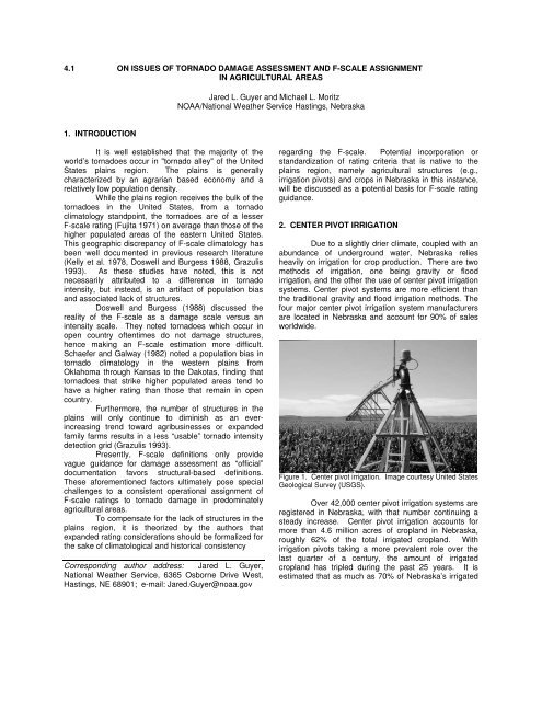
2. CENTER PIVOT IRRIGATION<br />
Due to a slightly drier climate, coupled with an<br />
abundance <strong>of</strong> underground water, Nebraska relies<br />
heavily on irrigation for crop production. There are two<br />
methods <strong>of</strong> irrigation, one being gravity or flood<br />
irrigation, <strong>and</strong> the other the use <strong>of</strong> center pivot irrigation<br />
systems. Center pivot systems are more efficient than<br />
the traditional gravity <strong>and</strong> flood irrigation methods. The<br />
four major center pivot irrigation system manufacturers<br />
are located in Nebraska <strong>and</strong> account for 90% <strong>of</strong> sales<br />
worldwide.<br />
Figure 1. Center pivot irrigation. Image courtesy United States<br />
Geological Survey (USGS).<br />
Over 42,000 center pivot irrigation systems are<br />
registered in Nebraska, with that number continuing a<br />
steady increase. Center pivot irrigation accounts for<br />
more than 4.6 million acres <strong>of</strong> cropl<strong>and</strong> in Nebraska,<br />
roughly 62% <strong>of</strong> the total irrigated cropl<strong>and</strong>. With<br />
irrigation pivots taking a more prevalent role over the<br />
last quarter <strong>of</strong> a century, the amount <strong>of</strong> irrigated<br />
cropl<strong>and</strong> has tripled during the past 25 years. It is<br />
estimated that as much as 70% <strong>of</strong> Nebraska’s irrigated
acreage could be under center pivot systems by 2010.<br />
(UNL Institute <strong>of</strong> Agriculture <strong>and</strong> Natural Resources,<br />
2001).<br />
Although design specifications vary between<br />
manufacturers, center irrigation pivots typically extend<br />
for 0.25 miles in length <strong>and</strong> consist <strong>of</strong> 6 to 11 spans.<br />
Generally made <strong>of</strong> galvanized steel, the total weight for<br />
each tower <strong>and</strong> span (void <strong>of</strong> water) may range from<br />
3500 to 5000 lbs. The average irrigation pivot is<br />
capable <strong>of</strong> moving more than a million gallons <strong>of</strong> water<br />
per day (T-L Irrigation, 2002).<br />
Consultation with irrigation pivot manufacturers<br />
(i.e. T-L Irrigation) indicates a general 80 mph design<br />
st<strong>and</strong>ard for resistance to overturning in high wind<br />
situations (void <strong>of</strong> water loading). Although specific<br />
criteria for typical wind resistance for water loaded<br />
pivots are sparse, the overall overturning threshold<br />
would be considerably higher.<br />
Aside from fundamental design specifications,<br />
several additional factors must be considered when<br />
assessing damage to irrigation pivots. For example: (1)<br />
the original orientation <strong>of</strong> the pivot (2) whether the pivot<br />
is designed to “rock” or “roll” – is a braking system<br />
employed by the pivot? <strong>and</strong> (3) proximity <strong>of</strong> the damage<br />
to the center <strong>of</strong> the pivot – i.e. better anchoring near the<br />
tower directly attached to the water source.<br />
Given the propensity <strong>of</strong> irrigation pivots in the<br />
plains region, it would seem appropriate for inclusion<br />
into F-scale definitions <strong>and</strong>/or st<strong>and</strong>ards. Additional<br />
information <strong>and</strong> guidance by wind <strong>and</strong> agricultural<br />
engineers would ultimately be necessary to refine<br />
potential applications to damage assessment<br />
techniques.<br />
3. CROPS<br />
According the United States Department <strong>of</strong><br />
Agriculture, nearly 76 million acres <strong>of</strong> corn were planted<br />
in the United States in 2001, <strong>of</strong> which 8 million acres<br />
were planted in Nebraska. In south central Nebraska,<br />
approximately 5 million acres <strong>of</strong> corn <strong>and</strong> soybeans<br />
were planted, representing around one-half <strong>of</strong> the total<br />
l<strong>and</strong> area.<br />
Fujita (1993) utilized crop damage in his review<br />
<strong>of</strong> the Plainfield, IL tornado <strong>of</strong> 28 August 1990. He<br />
appeared to place a high factor <strong>of</strong> reliability <strong>and</strong><br />
importance on the damage observed in the crops<br />
(namely corn, wheat, <strong>and</strong> beans). Fujita went as far as<br />
identifying “comma-shaped”, “swirl-shaped”, <strong>and</strong> “eyeshaped”<br />
patterns in the crops.<br />
Representative pictures encompassed the<br />
entire F0 to F5 gamut. In the case <strong>of</strong> the Plainfield<br />
tornado, damage was so intense, Fujita surmised an<br />
area <strong>of</strong> F5 winds based upon corn damage alone. In this<br />
case, the corn stalk was almost completely ripped from<br />
the ground. Fujita characterized the “corn crops were<br />
stripped <strong>of</strong> leaves <strong>and</strong> ears <strong>and</strong> pushed practically down<br />
to the ground. In the worst damaged area, corn crops<br />
were blown away entirely, leaving behind the remnants<br />
<strong>of</strong> small roots connected to the underground root<br />
system.”<br />
Figure 3. <strong>Tornado</strong> damage to a corn field. Photo by first<br />
author.<br />
Figure 2. Map <strong>of</strong> center pivot irrigation systems in Nebraska<br />
based upon 1997 data. Map courtesy <strong>of</strong> the Center for<br />
Advanced L<strong>and</strong> Management Information Technologies<br />
(CALMIT).<br />
In assessing F-scale damage in rural areas,<br />
notably corn fields, many conditions should be<br />
considered. Obviously the timing <strong>and</strong> velocity <strong>of</strong> the<br />
wind is important, but so is the stage <strong>of</strong> growth <strong>of</strong> the<br />
corn plant. The plant is most susceptible to breakage<br />
during rapid growth stages (approximately 2 to 3 feet<br />
high), which is usually in June. Historically, June<br />
corresponds to peak tornado activity in Nebraska. As<br />
the plant matures to the tasselling stage in July, the<br />
stalk will strengthen <strong>and</strong> may be able to withst<strong>and</strong><br />
stronger winds (Pioneer Hi-Bred International, 1999).
Different corn plants, or hybrids, are tested for<br />
stalk breakage. Brittle snap (also known as green snap)<br />
is a term which describes a corn plant stalk which has<br />
been broken by high winds. The brittle stalk score is a<br />
score which reflects artificial testing <strong>of</strong> a hybrid’s<br />
tendency <strong>and</strong> frequency for brittle stalk breakage. A<br />
score <strong>of</strong> 9 indicates the least risk <strong>of</strong> breakage <strong>and</strong> 1<br />
indicates the highest risk. A score <strong>of</strong> 9 does not<br />
guarantee resistance to brittle snap though. Other<br />
factors such as planting practices, fertilizing<br />
methodology, <strong>and</strong> soil conditions can also affect a<br />
plant’s susceptibility to damage caused by high winds or<br />
tornadoes (Pioneer Hi-Bred International, 1999).<br />
Too many factors (e.g., growing cycle, soil<br />
moisture variability, crop health) may be involved to<br />
reliably utilize crop damage as a sole source <strong>of</strong> an<br />
F-scale rating; nevertheless, there may be utility as a<br />
supplementary means <strong>of</strong> guidance.<br />
4. CONCLUDING REMARKS AND SUGGESTIONS<br />
For the sake <strong>of</strong> consistency in operational<br />
F-scale assignment amongst geographic regions, the<br />
authors suggest the F-scale incorporate additional nonstructural<br />
types <strong>of</strong> damage. The authors propose that<br />
F-scale definitions <strong>and</strong>/or guidelines be exp<strong>and</strong>ed to<br />
better incorporate those things native to rural <strong>and</strong><br />
agricultural settings.<br />
Specifically, it is suggested F-scale<br />
descriptions should be refined to incorporate such<br />
things as irrigation pivots, agricultural crops, <strong>and</strong> other<br />
types <strong>of</strong> vegetation. With more inclusive definitions, it is<br />
theorized that the discrepancy in F-scale climatology<br />
between rural <strong>and</strong> higher populated areas may at least<br />
be partially minimized.<br />
Furthermore, the authors encourage other<br />
National Weather Service (NWS) <strong>of</strong>fices to research<br />
local st<strong>and</strong>ards <strong>and</strong> specifications within their own area<br />
<strong>of</strong> responsibility. The authors recommend those who<br />
routinely conduct surveys in rural areas consider the<br />
unique nature <strong>of</strong> the structures <strong>and</strong> green cover in their<br />
areas. If relatively little background information is<br />
known about the structures (i.e. pivots) or green cover<br />
(crop maturity <strong>and</strong> hybrids), the authors suggest<br />
obtaining information from local producers <strong>and</strong><br />
manufacturers to provide more consistency in tornado<br />
damage assessment. Ultimately, the locally derived<br />
information should be shared for the purposes <strong>of</strong><br />
statewide <strong>and</strong> regional uniformity.<br />
5. ACKNOWLEDGEMENTS<br />
The authors would like to thank T-L Irrigation<br />
for their time <strong>and</strong> consultation on this project. The<br />
various reviewers <strong>of</strong> this manuscript are acknowledged<br />
for the constructive comments <strong>and</strong> valuable input.<br />
6. REFERENCES<br />
Doswell, C.A., III, <strong>and</strong> D.W. Burgess, 1988: Some<br />
issues <strong>of</strong> United States tornado climatology. Mon. Wea.<br />
Rev., 116, 495-501.<br />
Fujita, T.T., 1971: Proposed characterization <strong>of</strong><br />
tornadoes <strong>and</strong> hurricanes by area <strong>and</strong> intensity. SMRP<br />
Res. Paper 91, Univ. <strong>of</strong> Chicago, 42 pp.<br />
Fujita, T.T., 1993: Plainfield <strong>Tornado</strong> <strong>of</strong> August 28,<br />
1990. The <strong>Tornado</strong>: Its Structure, Dynamics,<br />
Prediction, <strong>and</strong> Hazards. Geophysical Monograph 79,<br />
1993. American Geophysical Union.<br />
Grazulis, T.P., 1993: A 100-Year Perspective <strong>of</strong><br />
Significant <strong>Tornado</strong>es. The <strong>Tornado</strong>: Its Structure,<br />
Dynamics, Prediction, <strong>and</strong> Hazards. Geophys. Monogr.<br />
79, Amer. Geophys. Union, 467-474.<br />
Grazulis, T.P., J.T. Schaefer, <strong>and</strong> R.F. Abbey Jr., 1993:<br />
Advances in tornado climatology, hazards, <strong>and</strong> risk<br />
assessment since tornado symposium II. The <strong>Tornado</strong>:<br />
Its Structure, Dynamics, Prediction, <strong>and</strong> Hazards.<br />
Geophys. Monogr. 79, Amer. Geophys. Union, 409-426.<br />
Institute <strong>of</strong> Agriculture <strong>and</strong> Natural Resources, 2001:<br />
Cornhusker Economics. Department <strong>of</strong> Agricultural<br />
Economics, University <strong>of</strong> Nebraska Lincoln.<br />
Kelly, D.L., J.T. Schaefer, R. P. McNulty, C.A. Doswell<br />
III <strong>and</strong> R.F. Abbey, Jr., 1978: An augmented tornado<br />
climatology. Mon. Wea. Rev., 106, 1172-1183.<br />
Pioneer Hi-Bred International, Inc., 1999: Crop Insights,<br />
Volume 9, Number 3.<br />
Schaefer, J.T., <strong>and</strong> J.G. Galway, 1982: Population<br />
biases in the tornado climatology. Preprints 12 th Conf.<br />
<strong>On</strong> Severe Local Storms, San Antonio, Amer. Meteor.<br />
Soc., 51-54.<br />
T-L Irrigation, 2002: Personal Communication.

![NSWW_ROC_Overview.ppt [Read-Only] - Storm Prediction Center ...](https://img.yumpu.com/26478320/1/190x146/nsww-roc-overviewppt-read-only-storm-prediction-center-.jpg?quality=85)


![NEW_PRODUCTS_imy.ppt [Read-Only] - Storm Prediction Center ...](https://img.yumpu.com/26478296/1/190x146/new-products-imyppt-read-only-storm-prediction-center-.jpg?quality=85)