Tornadoes from Squall Lines and Bow Echoes. Part I - Storm ...
Tornadoes from Squall Lines and Bow Echoes. Part I - Storm ...
Tornadoes from Squall Lines and Bow Echoes. Part I - Storm ...

Create successful ePaper yourself
Turn your PDF publications into a flip-book with our unique Google optimized e-Paper software.
FEBRUARY 2005 T R A P P E T A L . 23<br />
<strong>Tornadoes</strong> <strong>from</strong> <strong>Squall</strong> <strong>Lines</strong> <strong>and</strong> <strong>Bow</strong> <strong>Echoes</strong>. <strong>Part</strong> I: Climatological Distribution<br />
ROBERT J. TRAPP<br />
Purdue University, West Lafayette, Indiana<br />
SARAH A. TESSENDORF<br />
Colorado State University, Fort Collins, Colorado<br />
ELAINE SAVAGEAU GODFREY<br />
University of Oklahoma, Norman, Oklahoma<br />
HAROLD E. BROOKS<br />
National Severe <strong>Storm</strong>s Laboratory, Norman, Oklahoma<br />
(Manuscript received 10 February 2004, in final form 12 August 2004)<br />
ABSTRACT<br />
The primary objective of this study was to estimate the percentage of U.S. tornadoes that are spawned<br />
annually by squall lines <strong>and</strong> bow echoes, or quasi-linear convective systems (QLCSs). This was achieved by<br />
examining radar reflectivity images for every tornado event recorded during 1998–2000 in the contiguous<br />
United States. Based on these images, the type of storm associated with each tornado was classified as cell,<br />
QLCS, or other.<br />
Of the 3828 tornadoes in the database, 79% were produced by cells, 18% were produced by QLCSs, <strong>and</strong><br />
the remaining 3% were produced by other storm types, primarily rainb<strong>and</strong>s of l<strong>and</strong>fallen tropical cyclones.<br />
Geographically, these percentages as well as those based on tornado days exhibited wide variations. For<br />
example, 50% of the tornado days in Indiana were associated with QLCSs.<br />
In an examination of other tornado attributes, statistically more weak (F1) <strong>and</strong> fewer strong (F2–F3)<br />
tornadoes were associated with QLCSs than with cells. QLCS tornadoes were more probable during the<br />
winter months than were cells. And finally, QLCS tornadoes displayed a comparatively higher <strong>and</strong> statistically<br />
significant tendency to occur during the late night/early morning hours. Further analysis revealed a<br />
disproportional decrease in F0–F1 events during this time of day, which led the authors to propose that<br />
many (perhaps as many as 12% of the total) weak QLCSs tornadoes were not reported.<br />
1. Introduction<br />
The underst<strong>and</strong>ing of tornadoes <strong>and</strong> their formation<br />
has grown dramatically over the past several decades,<br />
owing to the ever-increasing availability of visual <strong>and</strong> in<br />
situ observations, weather radar <strong>and</strong> satellite data, <strong>and</strong><br />
sophisticated computer model simulations of severe<br />
convective storms (see the recent reviews by Davies-<br />
Jones et al. 2001 <strong>and</strong> Wilhelmson <strong>and</strong> Wicker 2001).<br />
Concomitant with this growth in knowledge has been<br />
an expansion of the accepted realm of the types of<br />
possible convective storms that produce tornadoes.<br />
Based on our current underst<strong>and</strong>ing, these range <strong>from</strong><br />
Corresponding author address: Dr. Robert J. Trapp, Dept. of<br />
Earth <strong>and</strong> Atmospheric Sciences, Purdue University, 550 Stadium<br />
Mall Drive, West Lafayette, IN 47907.<br />
E-mail: jtrapp@purdue.edu<br />
supercell/mesocyclonic thunderstorms, complete with<br />
subtypes such as “low topped” or “mini” (e.g., Kennedy<br />
et al. 1993) <strong>and</strong> “high precipitating” (Moller et al.<br />
1990); nonsupercell/nonmesocyclonic thunderstorms<br />
(Wakimoto <strong>and</strong> Wilson 1989; Brady <strong>and</strong> Szoke 1989);<br />
prefrontal rainb<strong>and</strong>s (Carbone 1983); tropical cyclones<br />
(Spratt et al. 1997; McCaul 1987); <strong>and</strong> squall lines <strong>and</strong><br />
bow echoes (e.g., Hamilton 1970; Forbes <strong>and</strong><br />
Wakimoto 1983; Wakimoto 1983; <strong>and</strong> many others),<br />
which out of convenience we will refer to as either lines<br />
or quasi-linear convective systems (QLCSs).<br />
Interestingly, prior to Browning’s (1964) description<br />
of the supercell model—<strong>and</strong> in particular during the<br />
1940s–50s (<strong>and</strong> perhaps earlier)—squall lines were considered<br />
by many to be the primary host of tornadoes<br />
(e.g., Lloyd 1942; Fulks <strong>and</strong> Smith 1950). Obviously this<br />
must be interpreted within the context of that era, during<br />
which “squall lines,” “instability lines,” <strong>and</strong> “upper-<br />
© 2005 American Meteorological Society
24 WEATHER AND FORECASTING VOLUME 20<br />
level cold fronts” all were used somewhat interchangeably<br />
to describe lines of convective storms, be they continuous<br />
lines or broken lines or perhaps even lines of<br />
distinct supercells.<br />
Brunk (1953) ostensibly had a dissenting opinion of<br />
the time, stating that tornadoes “usually [occur] before<br />
the formation of a squall line” <strong>and</strong> moreover that they<br />
“frequently occur when there is no identifiable squall<br />
line.” In essence, this describes the current perception;<br />
based on a survey of contemporary tornado research<br />
activities (see, e.g., Davies-Jones et al. 2001), supercells<br />
appear to pose the most significant tornado threat,<br />
spawning a large percentage of the approximately 1200<br />
tornadoes that occur within the contiguous United<br />
States on average each year.<br />
As we show below, this focus on supercells is partly<br />
justified, especially since supercells are responsible for<br />
a large number of the strong-to-violent tornadoes (section<br />
3). However this risk of strong <strong>and</strong> even violent<br />
tornadoes is not limited to supercells. Indeed, consider<br />
the tornadic squall line that occurred on 11 November<br />
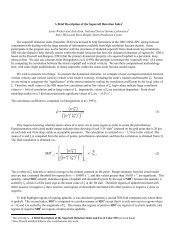
1995 near Flora, Mississippi (Fig. 1). At 0910 UTC<br />
(0310 LST), this 300 km long squall line produced an<br />
F3 (Fujita 1981) tornado that persisted on the ground<br />
for 15 mi. Another F3 tornado formed at 1055 UTC<br />
(0455 LST), <strong>and</strong> had a 7-mi pathlength. Neither tornado<br />
was preceded by a user-defined tornadic vortex<br />
signature (TVS) by more than 10 min in radar scans<br />
collected by the Jackson, Mississippi (KJAN), Weather<br />
Surveillance Radar-1988 Doppler (WSR-88D; see<br />
Trapp et al. 1999). Hence, as in the other cases of QLCS<br />
tornadoes preliminarily investigated by Trapp et al.<br />
FIG. 1. Radar reflectivity factor (dBZ ) <strong>from</strong> the KJAN WSR-88D, showing the tornadic squall line at<br />
0909 UTC on 11 Nov 1995. Elevation angle is 0.5°, range rings are indicated at 50-km intervals, <strong>and</strong> the<br />
approximate location of tornado is indicated by a “T.”
FEBRUARY 2005 T R A P P E T A L . 25<br />
(1999), traditional radar-based indicators of impending<br />
tornadogenesis likely offered little operational tornadowarning<br />
guidance for this event. And since this example<br />
(which is one of several) of QLCS tornado occurrence<br />
happened during the overnight hours, guidance <strong>from</strong><br />
storm spotters would have also been diminished, as<br />
would have the effectiveness of warning dissemination.<br />
Fortunately, no fatalities were associated with these<br />
tornadoes, although both resulted in two injuries <strong>and</strong> a<br />
total of $1 million in damage.<br />
The Mississippi squall-line example, in addition to<br />
examples presented by Wakimoto (1983), Forbes <strong>and</strong><br />
Wakimoto (1983), <strong>and</strong> others in the informal literature,<br />
illustrate that QLCS tornadoes can (i) be strong <strong>and</strong> (ii)<br />
have longer-than-average duration; in the absence of all<br />
but anecdotal evidence, we speculate that QLCS tornadoes<br />
are generally thought of as weak <strong>and</strong> short lived in<br />
the meteorological community, even though these<br />
qualifiers fit the majority of tornadoes in toto. The large<br />
horizontal length scale of the example case also draws<br />
attention to the considerable areal extent of possible<br />
tornado-breeding sites in QLCSs. Compounding this<br />
implied forecasting challenge is the apparent tendency<br />
for rapid QLCS tornado development, perhaps frequently<br />
during the overnight hours.<br />
In future research, we will address this forecasting<br />
challenge explicitly by characterizing the environmental<br />
conditions under which tornadic QLCSs occur, <strong>and</strong><br />
by determining their Doppler radar–derived attributes.<br />
Our objective here, however, is to define the scope of<br />
the problem by estimating the percentage, relative to<br />
all tornadoes, of QLCS tornadoes in the United States.<br />
This is accomplished by a classification of parent storm<br />
type using radar reflectivity images (section 2). The<br />
QLCS tornadoes are then distributed <strong>and</strong> analyzed statistically<br />
according to damage intensity, geographic region,<br />
<strong>and</strong> time <strong>and</strong> date of occurrence (section 3). Conclusions<br />
are made in section 4.<br />
2. Parent storm classification<br />
Tornado-damage assessment information <strong>and</strong> radar<br />
reflectivity images compose the data used for the parent<br />
storm classification <strong>and</strong> subsequent analysis. Both<br />
were obtained through the online database maintained<br />
by the National Climatic Data Center (NCDC, available<br />
online at http://www.ncdc.noaa.gov/). Individual<br />
records 1 of each tornado that occurred between January<br />
1998 <strong>and</strong> December 2000 in the contiguous United<br />
States were downloaded <strong>and</strong> incorporated into our database.<br />
The records include information such as the<br />
1 Essentially, the information found in these digital records is<br />
the same as that found in <strong>Storm</strong> Data, a National Oceanic <strong>and</strong><br />
Atmospheric Administration (NOAA) publication based on<br />
NCDC records.<br />
beginning <strong>and</strong> ending times/locations of the tornados,<br />
damage pathlengths <strong>and</strong> widths, numbers of fatalities<br />
<strong>and</strong> injuries, Fujita scale rating (Fujita 1981), <strong>and</strong> dollar<br />
amounts of property <strong>and</strong> crop damage. Note that although<br />
reports of funnel clouds <strong>and</strong> waterspouts were<br />
omitted <strong>from</strong> our database, waterspouts that moved onshore<br />
were included because they then have a definable<br />
damage track <strong>and</strong> an F-scale rating.<br />
Parent storm type was determined by examining<br />
composites of (column maximum) radar reflectivity,<br />
valid nearest the time of reported tornadogenesis. We<br />
initially consulted the images <strong>from</strong> the NCDC archive,<br />
but obtained higher-resolution images <strong>from</strong> numerous<br />
other sources if the spatial (8 km) <strong>and</strong>/or temporal<br />
(hourly) resolution of the NCDC images were insufficient<br />
to discern parent storm type, or if necessary composites<br />
were missing. This procedure facilitated the labor-intensive<br />
categorization of a large number of<br />
events.<br />
Each parent storm was classified simply as cell,<br />
QLCS, or other, guided by somewhat arbitrary radar<br />
reflectivity factor criteria: a cell was a relatively isolated,<br />
circular or elliptically shaped region of reflectivity<br />
with maximum values typically greater than or equal<br />
to 50 dBZ; a QLCS was a quasi-linear region of radar<br />
reflectivity greater than or equal to 40 dBZ, continuously<br />
distributed over a horizontal distance greater<br />
than 100 km; <strong>and</strong> the other category was populated<br />
primarily by tornadic outer rainb<strong>and</strong>s of l<strong>and</strong>fallen<br />
tropical cyclones. Despite the documentation of supercell-like<br />
features in small cells embedded in such b<strong>and</strong>s<br />
(McCaul 1987; Spratt et al. 1997), <strong>and</strong> the suggestion by<br />
Robe <strong>and</strong> Emanuel (2001) that outer b<strong>and</strong>s are tropical<br />
squall lines within the “kinematic environment of tropical<br />
cyclones,” the possible implications that this unique<br />
kinematic environment may have on tornadic rainb<strong>and</strong>s<br />
warranted, in our opinion, a separation of rainb<strong>and</strong>s<br />
<strong>from</strong> cells <strong>and</strong> QLCSs. The other category was<br />
also used for storms that could not be readily classified,<br />
as well as for events for which radar data could not be<br />
obtained.<br />
The distinction made herein between cells <strong>and</strong><br />
QLCSs is based on dynamics unique to these phenomena.<br />
This dynamical distinction is explained as follows.<br />
First, we fully recognize that QLCSs are, by definition,<br />
convective systems built <strong>from</strong> short-lived, highly interacting<br />
cells. A product of such cells is a surface-based,<br />
system-scale pool of rain-cooled air that is fundamental<br />
to the dynamics of the QLCSs. Specifically, the cold<br />
pool helps govern the QLCS motion (see, e.g., Weisman<br />
<strong>and</strong> Trapp 2003), even though individual cells may<br />
have a motion different <strong>from</strong> that of the QLCS<br />
(Bluestein <strong>and</strong> Jain 1985). It also provides for a strong,<br />
leading-edge baroclinic zone, <strong>and</strong> hence for strong horizontal<br />
vorticity that may be tipped into the vertical to<br />
help form tornado-producing “mesovortices” at low<br />
levels (Trapp <strong>and</strong> Weisman 2003). In contrast, a convective<br />
entity that we have classified as a cell may have
26 WEATHER AND FORECASTING VOLUME 20<br />
been a supercell whose dynamics <strong>and</strong> tornadogenesis<br />
are regulated largely by a mesocyclone (e.g., Rotunno<br />
<strong>and</strong> Klemp 1985). The other possible type of tornadic<br />
cell allowed by our classification scheme is a single cumulus<br />
congestus or growing cumulonimbus that produces<br />
a tornado by locally concentrating preexisting<br />
mesoscale vertical vorticity (Wakimoto <strong>and</strong> Wilson<br />
1989; Brady <strong>and</strong> Szoke 1989). Formal subclassification<br />
of these two cell types fell outside the objective of this<br />
study, however.<br />
Unavoidably subjective at times, our classification of<br />
convective lines should be consistent with that of other<br />
studies (e.g., Geerts 1998; Parker <strong>and</strong> Johnson 2000),<br />
although a duration criterion was not employed herein.<br />
Animation of reflectivity images aided us in our stormtype<br />
determination. We reiterate that the storm type at<br />
the reported time of tornado formation was what we<br />
recorded. Hence, a squall line (line of supercells) that<br />
some time after tornado occurrence fractured into distinct<br />
cells (coalesced into a continuous line) was still<br />
recorded as a QLCS (cell).<br />
We acknowledge that there are problems with tornado<br />
reporting. For example, tornado reports are likely<br />
to be more accurate with respect to location than to<br />
time because a tornado’s location can be deduced <strong>from</strong><br />
the damage path, whereas the time of the tornado is<br />
based upon eyewitness account (Witt et al. 1998).<br />
Hence, when we could not initially reconcile the NCDC<br />
report with the corresponding radar data (e.g., no echoes<br />
at the reported time <strong>and</strong> location), we inspected<br />
other radar images within 1 h of the reported time<br />
<strong>and</strong> attempted to match a storm echo with the reported<br />
damage location. We omitted the report <strong>from</strong> our database<br />
if unambiguous reconciliation was not possible.<br />
Such erroneous reports are assumed herein to<br />
be unbiased toward a particular parent storm type.<br />
The possibility of storm-type biases <strong>from</strong> accurate reports<br />
is, however, acknowledged <strong>and</strong> discussed in section<br />
3.<br />
Besides these reporting errors, we also accounted for<br />
tornadoes that crossed geopolitical boundaries. In<br />
<strong>Storm</strong> Data, a tornado that affects more than one<br />
county <strong>and</strong>/or state is given a separate record per<br />
county/state that contains the tornado’s attributes (F<br />
scale, damage path, etc.) in that county/state. This geopolitical<br />
segmentation of the tornado report was removed<br />
in our database. So, “property damage” is the<br />
total property damage due to the tornado, the “F scale”<br />
is the maximum F scale along the entire tornado track,<br />
etc.<br />
3. Results<br />
According to our database, 3828 tornadoes occurred<br />
in the contiguous United States during the 1998–2000<br />
calendar years. Cells produced 79% of these tornadoes,<br />
<strong>and</strong> QLCSs produced another 18% (Table 1). Other<br />
TABLE 1. The distribution of U.S. tornadoes by parent storm<br />
type during 1998–2000.<br />
Cumulative 1998 1999 2000<br />
Cell 3013 (79%) 1092 (77%) 1070 (80%) 851 (80%)<br />
QLCS 693 (18%) 244 (17%) 240 (18%) 208 (20%)<br />
Other 123 (3%) 81 (6%) 31 (2%) 11 (1%)<br />
Total 3828 1417 1341 1070<br />
storm types (mostly rainb<strong>and</strong>s of tropical cyclones)<br />
were credited with only 3% of the tornadoes; although<br />
we regard these events as operationally important <strong>and</strong><br />
interesting, we have chosen for the purposes of this<br />
paper to limit much of our subsequent discussion to cell<br />
<strong>and</strong> QLCS tornadoes.<br />
Surprisingly good year-to-year consistency is shown<br />
in percentages of QLCS <strong>and</strong> cell tornadoes. Considering<br />
that the storm-type classification work was done<br />
sporadically over several years, this result gives us faith<br />
that our simple classification is robust <strong>and</strong> that our<br />
sample is reasonably representative. We can quantify<br />
this further by estimating confidence intervals about<br />
our sample percentages. As with most commonly used<br />
statistical analysis techniques, however, we must first<br />
make the implicit assumption that each tornado event<br />
in our dataset is independent. We view independence<br />
here in terms of individual parent storms. So, for example,<br />
independence is a good assumption when a<br />
given storm produced only one tornado. In instances of<br />
multiple tornadoes per parent storm, the assumption<br />
should still be fairly good provided that individual<br />
events had some time <strong>and</strong>/or space separation (e.g., 1<br />
h, 100 km, respectively). The events that remain were<br />
usually associated with large outbreaks of tornadoes<br />
(e.g., 3 May 1999 in Oklahoma <strong>and</strong> Kansas), <strong>and</strong> these<br />
tended to be associated with cells.<br />
Since the true distribution of tornadoes by parent<br />
storm type is unknown, <strong>and</strong> our sample is still relatively<br />
small, we obtained confidence intervals for the percentages<br />
of QLCS <strong>and</strong> cell tornadoes using the bootstrap<br />
technique (Wilks 1995). A nonparametric or distribution-free<br />
method like bootstrap requires no assumptions<br />
about whether the data fit a particular theoretical<br />
distribution such as the well-known normal distribution.<br />
To use the bootstrap here, we r<strong>and</strong>omly resampled<br />
(with replacement) our dataset of storm-type classified<br />
tornadoes to create a very large number (10 000)<br />
of synthetic datasets. We then applied the percentile<br />
method to the replicated data. The resultant 95% confidence<br />
intervals for the percentages of QLCS <strong>and</strong> cell<br />
tornadoes are [16.9%, 19.3%] <strong>and</strong> [77.4%, 80.0%] respectively.<br />
Our estimates of U.S. tornadoes spawned<br />
annually by QLCSs <strong>and</strong> cells appear, therefore, to be<br />
statistically significant at this level.<br />
The distribution of total tornado days (d T ; see<br />
Brooks et al. 2003 <strong>and</strong> references therein) by parent<br />
storm type during 1998–2000 suggests a slightly higher<br />
percentage of QLCS tornadoes (25%) over the 3-yr
FEBRUARY 2005 T R A P P E T A L . 27<br />
period of study (Table 2). This alternative representation<br />
of the tornado distribution is not affected by<br />
large outbreaks over a single day that, by virtue of<br />
Table 2, appear to be associated mostly with cell tornadoes;<br />
it also tends to exhibit less temporal variability<br />
owing to lower sensitivity to the nonmeteorological<br />
factors that have inflated the tornado record over the<br />
past 50 yr (Brooks et al. 2003). We note that our counts<br />
of tornado days by parent storm type allowed for<br />
the joint occurrence of a cell-tornado day (d c ) <strong>and</strong> a<br />
QLCS tornado day (d L ; <strong>and</strong>/or “other” tornado day,<br />
d o ) on a given calendar day. Hence, the percentages in<br />
Table 2 were computed with respect to the sum of tornado<br />
days due to each storm type ( d c d L d o ),<br />
which may be larger than the total number of tornado<br />
days ( d T ).<br />
a. Geographical distribution<br />
The number of tornadoes <strong>and</strong> tornado days as a function<br />
of storm type varied widely across the United<br />
States. This is summarized in Fig. 2, which quantifies<br />
the cell <strong>and</strong> QLCS tornado days as a function of state.<br />
Consistent with the analysis of Brooks et al. (2003),<br />
particularly large numbers of tornado days occurred in<br />
the southern Great Plains <strong>and</strong> in Florida as well as in<br />
the plains of Colorado (Fig. 2a).<br />
Throughout these specific areas, most of the tornado<br />
days (<strong>and</strong> tornadoes) were associated with cells (Fig.<br />
2b). While such a strong statement cannot be made for<br />
QLCS tornadoes in other areas of the country, we can<br />
state that the percentages of QLCS tornado days (<strong>and</strong><br />
tornadoes) exceeded 25% (the national average) in the<br />
states along a curved axis <strong>from</strong> Louisiana to Pennsylvania<br />
(Fig. 2c). Indeed, 50% of the tornado days in<br />
Indiana during the 3-yr study period were associated<br />
with QLCSs. We note that the large percentages in<br />
parts of New Engl<strong>and</strong> must be viewed with caution<br />
since these are associated with very low numbers of<br />
total tornado days (Fig. 2a).<br />
Limited previous results compare favorably with our<br />
analysis of the geographical distribution of QLCS tornadoes.<br />
Knupp et al. (1996) presented a preliminary<br />
classification of tornadic storms in northern Alabama<br />
that suggests at least the relatively frequent occurrence<br />
of tornadic QLCSs, as we also show in Fig. 2c.<br />
TABLE 2. The distribution of total U.S. tornado days by parent<br />
storm type during 1998–2000. Percentages are computed using the<br />
boldfaced value in “total” row, which is sum of cell, QLCS, <strong>and</strong><br />
other values ( d C d L d O ). This need not be equal to the total<br />
number of tornado days ( d T ), indicated in italics.<br />
Cumulative 1998 1999 2000<br />
Cell 540 (72%) 185 (71%) 162 (70%) 193 (75%)<br />
QLCS 185 (25%) 64 (24%) 60 (26%) 61 (24%)<br />
Other 25 (3%) 13 (5%) 8 (3%) 4 (1%)<br />
Total 750 587 262 198 230 181 258 208<br />
FIG. 2. Geographical distribution of (a) all tornado days, (b) all<br />
tornado days due to cells, <strong>and</strong> (c) the percentage of all tornado<br />
days due to QLCSs, for 1998–2000.<br />
Though confined to derecho- (<strong>and</strong> not necessarily tornado-)<br />
producing MCSs, the 10-yr study by Bentley <strong>and</strong><br />
Mote (1998) shows maxima in occurrences that extend<br />
in part through Oklahoma–Texas <strong>and</strong> through Ohio–<br />
Pennsylvania.
28 WEATHER AND FORECASTING VOLUME 20<br />
b. Distribution by F scale<br />
The 50-yr tornado record analyzed by Brooks <strong>and</strong><br />
Doswell (2001) exhibits a log-linear distribution of tornado<br />
occurrence as a function of the Fujita (F) scale.<br />
The set of all tornadoes in our smaller record also exhibits<br />
a log-linear F-scale distribution (Fig. 3a) <strong>and</strong>, not<br />
surprisingly, so do the cell tornadoes. In comparison,<br />
the QLCS tornadoes are distributed differently, as<br />
shown more clearly when the entire QLCS-tornado dis-<br />
FIG. 3. 1998–2000 U.S. tornado distribution by F scale <strong>and</strong> parent storm type (cell, QLCS, other), presented (a) with<br />
all tornadoes <strong>and</strong> (b) with the distribution of QLCSs adjusted or normalized such that it has 237 F2 tornadoes.
FEBRUARY 2005 T R A P P E T A L . 29<br />
tribution is artificially shifted so that the number of F2<br />
QLCS tornadoes equals the number of F2 cell tornadoes<br />
(Fig. 3b). Indeed, there appear to be disproportionately<br />
more F1 tornadoes <strong>from</strong> QLCSs, <strong>and</strong> more<br />
F3–F4 tornadoes <strong>from</strong> cells. This is examined below.<br />
The disparity between F0 QLCS <strong>and</strong> cell tornadoes is<br />
likely due to the underreporting of QLCS events (see,<br />
also, Knupp 2000), which is addressed in section 3d.<br />
Finally, the absence of F5 QLCS tornadoes is consistent<br />
with the relative infrequency of F5 tornadoes, which<br />
comprise less than 0.2% of cell tornadoes in the dataset.<br />
It is unclear whether these differences between the<br />
two F-scale distributions are due to the relatively small<br />
QLCS tornado sample size or if they occur naturally.<br />
We can test this using the Monte Carlo method, in<br />
which a statistical model is simulated—under the assumption<br />
that the null hypothesis (H o ) is true—using<br />
artificially generated data that are consistent with the<br />
observed data (von Storch <strong>and</strong> Zwiers 2002). Specifically,<br />
a large number of realizations of some test statistic<br />
are generated to construct an empirical estimate of<br />
the distribution of the test statistic under H o . This distribution<br />
then provides the means for H o rejection at<br />
some significance level.<br />
One null hypothesis of particular interest is that the<br />
probability of a strong (F2–F3) tornado, given a QLCS,<br />
is the same as the probability of a strong tornado, given<br />
a cell. The Monte Carlo technique was used to test this<br />
hypothesis as follows (see Godfrey 2003 for more details).<br />
First, F0 tornadoes were disregarded (see below).<br />
This left a sample of 336 F1 <strong>and</strong> greater QLCS tornadoes,<br />
<strong>and</strong> also a sample of 1021 F1 <strong>and</strong> greater cell<br />
tornadoes that were used to compute the cumulative<br />
probabilities of cell F scales (Table 3); in other words,<br />
the observed F-scale distribution of cell tornadoes<br />
was assumed to represent the “truth.” We then drew<br />
a sufficiently large number (10 000; von Storch <strong>and</strong><br />
Zwiers 2002) of 336-member samples of r<strong>and</strong>om numbers<br />
between 0 <strong>and</strong> 1. Each r<strong>and</strong>om number in a 336-<br />
member sample was put into the appropriate F1–F5<br />
bin according to the cumulative cell probability table.<br />
The result was an F-scale distribution for each of the<br />
10 000 realizations or years of simulated tornadoes. Finally,<br />
these simulated F-scale distributions were compared<br />
to the observed QLCS F-scale distribution. The<br />
comparison was quantified as a percentage of realizations<br />
in which there were more observed QLCS tornadoes<br />
in an F-scale bin than there were simulated (cell)<br />
tornadoes.<br />
From Fig. 4, we see that every one of the 10 000<br />
simulated distributions had fewer than 263 F1 tornadoes<br />
(the portion of the 336 total observed QLCS tornadoes<br />
that were rated F1). In other words, at the 100%<br />
confidence level, there were significantly more F1 tornadoes<br />
<strong>from</strong> QLCSs than <strong>from</strong> cells. In contrast, at the<br />
99% <strong>and</strong> 100% confidence levels, respectively, there<br />
were significantly fewer F2 <strong>and</strong> F3 tornadoes <strong>from</strong><br />
QLCSs than <strong>from</strong> cells. There were also fewer F4 <strong>and</strong><br />
F5 QLCS tornadoes (89% <strong>and</strong> 63% confidence levels,<br />
respectively), but no significant conclusions can be<br />
drawn about these tornadoes because the events are<br />
particularly rare, even in cells.<br />
We conclude that, statistically, the F-scale distribution<br />
of QLCS tornadoes <strong>from</strong> the 3-yr dataset is significantly<br />
different than that of cell tornadoes. The probability<br />
that tornadoes <strong>from</strong> cells could have had the<br />
same distribution as tornadoes <strong>from</strong> QLCSs in the F1–<br />
F3 range is less than 1%. QLCSs produced many more<br />
F1 yet many fewer F2–F3 tornadoes than cells did.<br />
QLCSs were less likely to produce strong tornadoes<br />
than were cells, thus allowing us to reject our null hypothesis.<br />
c. Distribution by monthly occurrence<br />
Cell as well as QLCS tornadoes tended to be most<br />
frequent during the months of April through June (Fig.<br />
5). Generally speaking, the occurrence of QLCS tornadoes<br />
in our 3-yr dataset was biased toward the first half<br />
of the calendar year, with a comparatively higher likelihood<br />
in January through March. Such early year<br />
QLCS tornadoes were found in greatest numbers in<br />
Florida (45), Louisiana (31), <strong>and</strong> Texas (31), consistent<br />
with (though not necessarily wholly explaining) the<br />
maxima in tornado day probabilities for 19 February<br />
shown by Brooks et al. (2003, their Fig. 7a). Interestingly,<br />
strong (F2–F3) QLCS tornadoes occurred with a<br />
TABLE 3. Cumulative probabilities of cell tornadoes by F scale,<br />
based on 1998–2000 U.S. tornadoes. The probabilities exclude F0<br />
tornadoes.<br />
F scale<br />
Cumulative cell-tornado probability<br />
F1 1.000000<br />
F2 0.346719<br />
F3 0.114594<br />
F4 0.022527<br />
F5 0.002938<br />
FIG. 4. Histogram of 1998–2000 U.S. QLCS tornado distribution<br />
by F scale, <strong>and</strong> percentage of the 10 000 Monte Carlo realizations<br />
in which there were more observed QLCS tornadoes in an F-scale<br />
bin than there were simulated (cell) tornadoes. Realizations are<br />
based on 336 cell tornadoes, which excludes F0 cell tornadoes.
30 WEATHER AND FORECASTING VOLUME 20<br />
FIG. 5. 1998–2000 U.S. tornado distribution by month of occurrence<br />
<strong>and</strong> parent storm type (cell or QLCS). Percentage is based<br />
on total number of events per storm type. “Weak” denotes F0–F1<br />
tornadoes, <strong>and</strong> “strong” denotes F2–F3 tornadoes.<br />
slightly higher frequency during this time than in May<br />
<strong>and</strong> June (Fig. 5). Strong cell tornadoes, on the other<br />
h<strong>and</strong>, were most frequent during the months of April<br />
<strong>and</strong> May.<br />
Cumulative probability distributions help us further<br />
quantify tornado as well as tornado day occurrence by<br />
month. As can be inferred <strong>from</strong> Fig. 6, 32% (29%) of<br />
the QLCS tornadoes (tornado days) occurred within<br />
the first three months of the year, compared to only<br />
14% (16%) for cell tornadoes (tornado days). We use<br />
this to motivate another null hypothesis: the probability<br />
of a tornado during the months of January–March,<br />
given a QLCS, is the same as the probability of a tornado<br />
during the months of January–March, given a cell.<br />
The Monte Carlo technique was used again for the hypothesis<br />
testing. All tornadoes were considered. Hence,<br />
we drew 10 000 693-member samples (number of QLCS<br />
tornadoes) of r<strong>and</strong>om numbers between 0 <strong>and</strong> 1. Each<br />
r<strong>and</strong>om number in a sample was binned according to<br />
the cumulative probabilities of cell-tornado occurrence<br />
by month (see Fig. 6). The resultant monthly distributions<br />
for each of the 10 000 simulated years were compared<br />
to the monthly distribution of observed QLCStornado<br />
occurrence, <strong>and</strong> then quantified as a percentage<br />
of realizations in which there were more observed<br />
QLCS tornadoes in a particular month bin than simulated<br />
(cell) tornadoes.<br />
The Monte Carlo results show the occurrence of significantly<br />
fewer QLCS tornadoes during the summer<br />
<strong>and</strong> early fall months, at or above the 95% confidence<br />
level (Fig. 7). For example, 9646 (or 96%) of the<br />
10 000 simulated years had monthly distributions with<br />
fewer than 138 QLCS tornadoes in the month of June.<br />
However, significantly more QLCS tornadoes occurred<br />
<strong>from</strong> January to March, <strong>and</strong> then again <strong>from</strong> November<br />
to December, at or above the 95% confidence level.<br />
Thus, we again reject our null hypothesis with high confidence,<br />
<strong>and</strong> conclude that QLCS tornadoes appear<br />
more likely to occur during the “cool season” than do<br />
cell tornadoes.<br />
d. Distribution by hourly occurrence<br />
We next present 3-h running means of the hourly<br />
distributions of tornadoes by parent storm type (Fig.<br />
8a). Cell tornadoes have a clear peak in occurrence<br />
near 1800 LST, which has been shown in previous studies<br />
for all tornadoes (e.g., Kelly et al. 1978). A similar<br />
daytime peak exists for QLCS tornadoes. But, these<br />
events additionally display a comparatively higher tendency<br />
to occur in the late night/early morning hours,<br />
which reflects the tendency of QLCSs in general to<br />
form in the late afternoon/early evening <strong>and</strong> then persist<br />
until morning (e.g., Bentley <strong>and</strong> Mote 1998). Cumulative<br />
probabilities of the 3-h running means of tornado<br />
occurrence (not shown) further quantify the differences<br />
with respect to storm type: 88% of cell<br />
tornadoes occurred between 1000 <strong>and</strong> 2000 LST, while<br />
37% of QLCS tornadoes occurred between 2000 <strong>and</strong><br />
1000 LST.<br />
We are particularly interested in the statistical sig-<br />
FIG. 6. Cumulative probabilities of occurrence of QLCS <strong>and</strong> cell<br />
tornadoes, <strong>and</strong> of QLCS- <strong>and</strong> cell-tornado days, by month of year,<br />
based on 1998–2000 U.S. tornadoes.<br />
FIG. 7. Percentage of the 10 000 Monte Carlo realizations in<br />
which there were more observed QLCS tornadoes in a given<br />
month than simulated (cell) tornadoes. Realizations are based on<br />
all (682) cell tornadoes during 1998–2000 in the United States.
FEBRUARY 2005 T R A P P E T A L . 31<br />
FIG. 8. Three-hour running mean of 1998–2000 U.S. tornado distribution by LST of occurrence<br />
<strong>and</strong> parent storm type (cell or QLCS), for (a) all tornadoes <strong>and</strong> (b) tornadoes as a<br />
function of F scale. Percentage in (a) is based on total number of events per storm type;<br />
percentage in (b) is based on total number of events per storm type in an F-scale range.<br />
nificance of the higher occurrences of QLCS tornadoes<br />
during the nighttime hours. Hence, we again applied<br />
the Monte Carlo technique, in this instance to evaluate<br />
the null hypothesis that the probability of a nighttime<br />
tornado, given a QLCS, is the same as the probability of<br />
a nighttime tornado, given a cell. All tornadoes were<br />
again considered, <strong>and</strong> thus 10 000 693-member samples<br />
(total number of QLCS tornadoes) of r<strong>and</strong>om numbers<br />
between 0 <strong>and</strong> 1 were drawn. Each r<strong>and</strong>om number in<br />
a sample was binned according to the cumulative probabilities<br />
of cell tornado occurrence by hour (see Table<br />
4). The resultant hourly distributions for each of the<br />
10 000 simulated years were compared to the hourly<br />
distribution of observed QLCS-tornado occurrence,<br />
<strong>and</strong> then quantified as a percentage of realizations in<br />
which there were more observed QLCS tornadoes in a<br />
particular hour bin than simulated (cell) tornadoes.<br />
At or above the 99% confidence level, there were<br />
significantly more tornadoes <strong>from</strong> QLCSs than <strong>from</strong><br />
cells during the nighttime <strong>and</strong> morning hours of 2100–<br />
0900 LST (Fig. 9). At this same confidence level there<br />
were significantly fewer tornadoes <strong>from</strong> QLCSs than<br />
<strong>from</strong> cells between 1600 <strong>and</strong> 2000 LST. We conclude<br />
that there is a statistically significant difference be-
32 WEATHER AND FORECASTING VOLUME 20<br />
TABLE 4. Cumulative probabilities of cell tornadoes by LST,<br />
based on 1998–2000 U.S. tornadoes.<br />
Local time Cumulative cell-tornado probability<br />
Midnight–1 0.007<br />
1–2 0.013<br />
2–3 0.017<br />
3–4 0.022<br />
4–5 0.028<br />
5–6 0.032<br />
6–7 0.036<br />
7–8 0.041<br />
8–9 0.046<br />
9–10 0.058<br />
10–11 0.073<br />
11–12 0.096<br />
12–1 0.131<br />
13–14 0.181<br />
14–15 0.256<br />
15–16 0.363<br />
16–17 0.489<br />
17–18 0.632<br />
18–19 0.769<br />
19–20 0.888<br />
20–21 0.946<br />
21–22 0.972<br />
22–23 0.989<br />
23–midnight 1<br />
FIG. 9. Percentage of the 10 000 Monte Carlo realizations in<br />
which there were more observed QLCS tornadoes in a given hour<br />
than simulated (cell) tornadoes. Realizations are based on all<br />
(682) cell tornadoes during 1998–2000 in the United States.<br />
tween the hourly distributions of QLCS <strong>and</strong> cell tornadoes,<br />
<strong>and</strong> in particular note that QLCS tornadoes appear<br />
more likely to occur during the nighttime <strong>and</strong><br />
early morning hours than do cell tornadoes.<br />
Other intriguing characteristics of the diurnal distribution<br />
are revealed when the hourly tornado data are<br />
separated by F scale. The weak (F0–F1) <strong>and</strong> strong<br />
(F2–F3) tornadoes <strong>from</strong> cells display a similar distribution<br />
throughout the day, with peaks in both between<br />
1600 <strong>and</strong> 1900 LST (Fig. 8b). In contrast, the percentage<br />
of strong QLCS tornadoes (21%) is noticeably<br />
higher than weak QLCS tornadoes (9%) during the<br />
overnight hours of 2300–0300 LST. We propose two<br />
possible explanations for this disparity between weak<br />
<strong>and</strong> strong QLCS tornadoes: (i) the genesis mechanisms<br />
<strong>and</strong>/or intensity-limiting processes of weak versus<br />
strong QLCS tornadoes are fundamentally different<br />
throughout the day, or (ii) weak QLCS tornadoes are<br />
underreported. The first explanation is plausible, but<br />
beyond the scope of the current study. The second explanation<br />
has support in other studies such as Knupp<br />
(2000), which suggest that (weak) QLCS-tornado damage<br />
may be masked by <strong>and</strong> hence mistakenly reported<br />
as straight-line wind damage. Visual confirmation of<br />
tornadoes during the night is also less likely.<br />
If, for the moment, we assume that whatever physical<br />
processes limit QLCS tornado intensity do not change<br />
fundamentally throughout the day, then the percentage<br />
of weak (F0–F1) QLCS tornadoes occurring in the<br />
near-midnight hours (2300–0200 LST) should be the<br />
same as the percentage of strong (F2–F3) tornadoes<br />
during these hours. Thus, N w-l-unrep , the number of<br />
weak QLCS tornadoes not reported during the nearmidnight<br />
hours, can be estimated as<br />
% weak 0200 2300<br />
N w-l-unrep N w-l <br />
% strong 0200 2300 1 .<br />
For N w-l 609, the percentage of weak tornadoes between<br />
0200 <strong>and</strong> 2300 LST is 91%, <strong>and</strong> the percentage of<br />
strong tornadoes between 0200 <strong>and</strong> 2300 LST is 79%,<br />
Eq. (1) yields 92 tornadoes. In other words, it is possible<br />
that 12% of all QLCS tornadoes in 1998–2000 were<br />
not reported. A similar calculation suggests that 1%<br />
of all cell tornadoes in 1998–2000 were not reported.<br />
4. Summary <strong>and</strong> conclusions<br />
The objective of this study was to estimate the percentage<br />
of U.S. tornadoes that are spawned annually by<br />
squall lines <strong>and</strong> bow echoes, or quasi-linear convective<br />
systems (QLCSs). This was achieved by examining national<br />
composite radar reflectivity images for every tornado<br />
event recorded during 1998–2000 in the contiguous<br />
United States. Based on radar reflectivity criteria<br />
applied to these images, we determined the type of the<br />
storm associated with each tornado. Our list of possible<br />
parent storm types was limited to cell, QLCS, or other.<br />
Of the 3828 tornadoes in our database, 79% were<br />
produced by cells, 18% were produced by QLCSs, <strong>and</strong><br />
the remaining 3% were produced by other storm types,<br />
primarily rainb<strong>and</strong>s of tropical cyclones. The percentage<br />
of QLCS tornadoes increased to 25% when the<br />
number of tornado days due to each storm type was<br />
considered. Geographically, these percentages exhibited<br />
wide variations. Of note are the states along a<br />
curved axis <strong>from</strong> Louisiana to Pennsylvania whose percentages<br />
of QLCS tornado days exceeded 25%. Of<br />
these states, Indiana had the highest percentage (50%)<br />
of QLCS tornado days during the 3-yr study period.<br />
In an examination of the Fujita scale of cell versus<br />
QLCS tornadoes, we found comparatively more F1 tor-<br />
1
FEBRUARY 2005 T R A P P E T A L . 33<br />
nadoes <strong>from</strong> QLCSs, <strong>and</strong> comparatively more F2–F3<br />
tornadoes <strong>from</strong> cells. A Monte Carlo test demonstrated<br />
that the probability of a weak tornado, given a QLCS,<br />
is much greater than the probability of a weak tornado,<br />
given a cell. No significant conclusions could be drawn<br />
about violent tornadoes because these events are particularly<br />
rare, regardless of parent storm type.<br />
Finally, the distributions of cell <strong>and</strong> QLCS tornado<br />
occurrence by month <strong>and</strong> by local time of day were<br />
considered. The occurrence of QLCS tornadoes was<br />
biased toward the first half of the calendar year, with a<br />
relatively high likelihood in January through March. A<br />
different Monte Carlo test confirmed this, showing that<br />
QLCS tornadoes were statistically more probable during<br />
the cool season than were cell tornadoes. As with<br />
cell tornadoes, however, QLCS tornadoes were most<br />
frequent during the months of April through June.<br />
Regarding local time of occurrence, cell tornadoes<br />
had a clear peak near 1800 LST, as did QLCS tornadoes.<br />
But, the QLCS events additionally displayed a<br />
comparatively higher <strong>and</strong> statistically significant tendency<br />
to occur in the late night/early morning hours.<br />
An examination of these events revealed a noticeably<br />
larger percentage of strong (F2–F3) versus weak (F0–<br />
F1) QLCS tornadoes during the period 2300–0300 LST.<br />
The lack of such a disparity in the diurnal distributions<br />
of cell-tornado intensities prompted us to pose that (i)<br />
the genesis mechanisms <strong>and</strong>/or intensity-limiting processes<br />
of weak versus strong QLCS tornadoes were fundamentally<br />
different throughout the day, or (ii) weak<br />
QLCS tornadoes were underreported. While thoughtprovoking,<br />
the first explanation was left for future research.<br />
Calculations based on a consideration of the<br />
second explanation suggest that as many as 12% of all<br />
QLCS tornadoes in 1998–2000 may not have been reported.<br />
The results <strong>from</strong> this study should provide a baseline<br />
than can help forecasters anticipate the risk of tornadic<br />
winds in QLCSs, especially in a given geographic location<br />
<strong>and</strong> season. Future research will address forecasting<br />
issues more specifically by characterizing the environmental<br />
conditions under which tornadic QLCSs occur,<br />
<strong>and</strong> by describing their Doppler radar–derived<br />
attributes.<br />
Acknowledgments. The authors wish to acknowledge<br />
<strong>and</strong> thank the following people <strong>and</strong> organizations for<br />
providing data <strong>and</strong> support: NCDC; S. Williams <strong>and</strong> J.<br />
Meitin (UCAR/JOSS); P. Neilly (NCAR/RAP); J.<br />
Steenburgh (University of Utah); UCAR/COMET; J.<br />
Miller, D. Ahijevych, <strong>and</strong> J. Knievel (NCAR/MMM);<br />
<strong>and</strong> S. Harrison (NASA MSFC). The authors also benefited<br />
<strong>from</strong> discussions with A. Gluhovsky (Purdue<br />
University), <strong>and</strong> D. Karoly <strong>and</strong> K. Droegemeier (University<br />
of Oklahoma). The first <strong>and</strong> third authors were<br />
sponsored in part by NSF ATM 0100016. The second<br />
author’s contribution to this project was through the<br />
UCAR/SOARS program.<br />
REFERENCES<br />
Bentley, M. L., <strong>and</strong> T. L. Mote, 1998: A climatology of derechoproducing<br />
mesoscale convective systems in the central <strong>and</strong><br />
eastern United States, 1986–95. <strong>Part</strong> I: Temporal <strong>and</strong> spatial<br />
distribution. Bull. Amer. Meteor. Soc., 79, 2527–2540.<br />
Bluestein, H. B., <strong>and</strong> M. H. Jain, 1985: Formation of mesoscale<br />
lines of precipitation: Severe squall lines in Oklahoma during<br />
the spring. J. Atmos. Sci., 42, 1711–1732.<br />
Brady, R. H., <strong>and</strong> E. J. Szoke, 1989: A case study of nonmesocyclone<br />
tornado development in northeast Colorado: Similarities<br />
to waterspout formation. Mon. Wea. Rev., 117, 843–856.<br />
Brooks, H., <strong>and</strong> C. A. Doswell III, 2001: Some aspects of the<br />
international climatology of tornadoes by damage classification.<br />
Atmos. Res., 56, 191–201.<br />
——, ——, <strong>and</strong> M. P. Kay, 2003: Climatological estimates of local<br />
daily tornado probability for the United States. Wea. Forecasting,<br />
18, 626–640.<br />
Browning, K. A., 1964: Airflow <strong>and</strong> precipitation trajectories<br />
within severe local storms which travel to the right of the<br />
winds. J. Atmos. Sci., 21, 634–639.<br />
Brunk, I. W., 1953: <strong>Squall</strong> lines. Bull. Amer. Meteor. Soc., 34, 1–9.<br />
Carbone, R. E., 1983: A severe frontal rainb<strong>and</strong>. <strong>Part</strong> II: Tornado<br />
parent vortex circulation. J. Atmos. Sci., 40, 2639–2654.<br />
Davies-Jones, R., R. J. Trapp, <strong>and</strong> H. B. Bluestein, 2001: <strong>Tornadoes</strong><br />
<strong>and</strong> tornadic storms. Severe Convective <strong>Storm</strong>s, Meteor.<br />
Monogr., No. 50, Amer. Meteor. Soc., 167–222.<br />
Forbes, G. S., <strong>and</strong> R. M. Wakimoto, 1983: A concentrated outbreak<br />
of tornadoes, downbursts, <strong>and</strong> microbursts, <strong>and</strong> implications<br />
regarding vortex classification. Mon. Wea. Rev., 111,<br />
220–235.<br />
Fujita, T. T., 1981: <strong>Tornadoes</strong> <strong>and</strong> downbursts in the context of<br />
generalized planetary scales. J. Atmos. Sci., 38, 1511–1534.<br />
Fulks, J. R., <strong>and</strong> C. D. Smith Jr., 1950: A December storm accompanied<br />
by tornadoes. Mon. Wea. Rev., 78, 220–225.<br />
Geerts, B., 1998: Mesoscale convective systems in the southeast<br />
United States during 1994–95: A survey. Wea. Forecasting,<br />
13, 860–869.<br />
Godfrey, E. B. S., 2003: A study of the environment <strong>and</strong> intensity<br />
of tornadoes <strong>from</strong> quasi-linear convective systems. M.S. thesis,<br />
School of Meteorology, University of Oklahoma, 83 pp.<br />
[Available <strong>from</strong> School of Meteorology, University of Oklahoma,<br />
100 E. Boyd, Norman, OK 73019.]<br />
Hamilton, R. E., 1970: Use of detailed intensity radar data in<br />
meso-scale surface analysis of the July 4, 1969 storm in Ohio.<br />
Preprints, 14th Conf. on Radar Meteorology, Tucson, AZ,<br />
Amer. Meteor. Soc., 339–342.<br />
Kelly, D. L., J. T. Schaefer, R. P. McNulty, C. A. Doswell III, <strong>and</strong><br />
R. F. Abbey Jr., 1978: An augmented tornado climatology.<br />
Mon. Wea. Rev., 106, 1172–1183.<br />
Kennedy, P. C., N. E. Wescott, <strong>and</strong> R. W. Scott, 1993: Single-<br />
Doppler radar observations of a mini-supercell tornadic<br />
thunderstorm. Mon. Wea. Rev., 121, 1860–1870.<br />
Knupp, K. R., 2000: Narrow streaks of “straight-line” wind damage.<br />
Do tornadoes or microbursts produce them? Preprints,<br />
20th Conf. on Severe Local <strong>Storm</strong>s, Orl<strong>and</strong>o, FL, Amer. Meteor.<br />
Soc., 644–645.<br />
——, R. L. Clymer, <strong>and</strong> B. Geerts, 1996: Preliminary classification<br />
<strong>and</strong> observational characteristics of tornadic storms over<br />
northern Alabama. Preprints, 18th Conf. on Severe Local<br />
<strong>Storm</strong>s, San Francisco, CA, Amer. Meteor. Soc., 447–450.<br />
Lloyd, J. R., 1942: The development <strong>and</strong> trajectories of tornadoes.<br />
Mon. Wea. Rev., 70, 65–75.<br />
McCaul, E. W., Jr., 1987: Observations of the Hurricane “Danny”<br />
tornado outbreak of 16 August 1985. Mon. Wea. Rev., 115,<br />
1206–1223.<br />
Moller, A. R., C. A. Doswell III, <strong>and</strong> R. Przybylinski, 1990: Highprecipitation<br />
supercells: A conceptual model <strong>and</strong> documentation.<br />
Preprints, 16th Conf. on Severe Local <strong>Storm</strong>s, Kananaskis<br />
Park, AB, Canada, Amer. Meteor. Soc., 52–57.<br />
Parker, M. D., <strong>and</strong> R. H. Johnson, 2000: Organizational modes of
34 WEATHER AND FORECASTING VOLUME 20<br />
midlatitude mesoscale convective systems. Mon. Wea. Rev.,<br />
128, 3413–3436.<br />
Robe, F. R., <strong>and</strong> K. A. Emanuel, 2001: The effect of vertical wind<br />
shear on radiative–convective equilibrium states. J. Atmos.<br />
Sci., 58, 1427–1445.<br />
Rotunno, R., <strong>and</strong> J. B. Klemp, 1985: On the rotation <strong>and</strong> propagation<br />
of simulated supercell thunderstorms. J. Atmos. Sci.,<br />
42, 271–292.<br />
Spratt, S. M., D. W. Sharp, P. Welsh, A. S<strong>and</strong>rik, F. Alsheimer,<br />
<strong>and</strong> C. Paxton, 1997: A WSR-88D assessment of tropical cyclone<br />
outer rainb<strong>and</strong> tornadoes. Wea. Forecasting, 12, 479–<br />
501.<br />
Trapp, R. J., <strong>and</strong> M. L. Weisman, 2003: Low-level mesovortices<br />
within squall lines <strong>and</strong> bow echoes. <strong>Part</strong> II: Their genesis <strong>and</strong><br />
implications. Mon. Wea. Rev., 131, 2804–2823.<br />
——, E. D. Mitchell, G. A. Tipton, D. W. Effertz, A. I. Watson, D.<br />
L. Andra Jr., <strong>and</strong> M. A. Magsig, 1999: Descending <strong>and</strong> nondescending<br />
tornadic vortex signatures detected by WSR-<br />
88Ds. Wea. Forecasting, 14, 625–639.<br />
von Storch, H., <strong>and</strong> F. W. Zwiers, 2002: Statistical Analysis in<br />
Climate Research. Cambridge University Press, 491 pp.<br />
Wakimoto, R. M., 1983: The West Bend, Wisconsin storm of 4<br />
April 1981: A problem in operational meteorology. J. Climate<br />
Appl. Meteor., 22, 181–189.<br />
——, <strong>and</strong> J. W. Wilson, 1989: Non-supercell tornadoes. Mon. Wea.<br />
Rev., 117, 1113–1140.<br />
Weisman, M. L., <strong>and</strong> R. J. Trapp, 2003: Low-level mesovortices<br />
within squall lines <strong>and</strong> bow echoes. <strong>Part</strong> I: Overview <strong>and</strong><br />
dependence on environmental shear. Mon. Wea. Rev., 131,<br />
2779–2803.<br />
Wilhelmson, R. B., <strong>and</strong> L. J. Wicker, 2001: Numerical modeling of<br />
severe local storms. Severe Convective <strong>Storm</strong>s, Meteor.<br />
Monogr., No. 50, Amer. Meteor. Soc., 123–166.<br />
Wilks, D. S., 1995: Statistical Methods in the Atmospheric Sciences.<br />
International Geophysics Series, Vol. 59, Academic Press,<br />
464 pp.<br />
Witt, A., M. D. Eilts, G. J. Stumpf, E. D. Mitchell, J. T. Johnson,<br />
<strong>and</strong> K. W. Thomas, 1998: Evaluating the performance of<br />
WSR-88D severe storm detection algorithms. Wea. Forecasting,<br />
13, 513–518.

![NSWW_ROC_Overview.ppt [Read-Only] - Storm Prediction Center ...](https://img.yumpu.com/26478320/1/190x146/nsww-roc-overviewppt-read-only-storm-prediction-center-.jpg?quality=85)


![NEW_PRODUCTS_imy.ppt [Read-Only] - Storm Prediction Center ...](https://img.yumpu.com/26478296/1/190x146/new-products-imyppt-read-only-storm-prediction-center-.jpg?quality=85)