2004 Tornado Reports - Storm Prediction Center - NOAA
2004 Tornado Reports - Storm Prediction Center - NOAA
2004 Tornado Reports - Storm Prediction Center - NOAA

You also want an ePaper? Increase the reach of your titles
YUMPU automatically turns print PDFs into web optimized ePapers that Google loves.
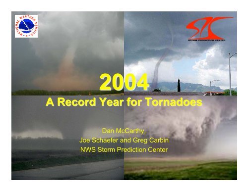
<strong>2004</strong><br />
A Record Year for <strong>Tornado</strong>es<br />
Dan McCarthy,<br />
Joe Schaefer and Greg Carbin<br />
NWS <strong>Storm</strong> <strong>Prediction</strong> <strong>Center</strong><br />
3/10/05 2005 National Severe Weather<br />
Workshop<br />
1
Main Aspects of <strong>2004</strong><br />
• Very slow start for tornadoes<br />
– Below normal through April<br />
– April highlight in Illinois<br />
• Two-personality May<br />
– Unfavorable pattern through the 19 th<br />
– Very favorable after the 20 th<br />
• A Tropical <strong>Storm</strong> and 5 Hurricanes<br />
• Busy “second season”<br />
THIS LEAD TO 1,722 TORNADO REPORTS IN <strong>2004</strong><br />
3/10/05 2005 National Severe Weather<br />
Workshop<br />
2
<strong>Tornado</strong>es By Year<br />
2000<br />
1800<br />
1600<br />
1400<br />
1200<br />
1000<br />
800<br />
600<br />
400<br />
200<br />
0<br />
Year<br />
3/10/05 2005 National Severe Weather<br />
Workshop<br />
1950<br />
1952<br />
1954<br />
1956<br />
1958<br />
1960<br />
1962<br />
1964<br />
1966<br />
1968<br />
1970<br />
1972<br />
1974<br />
1976<br />
1978<br />
1980<br />
1982<br />
1984<br />
1986<br />
1988<br />
1990<br />
1992<br />
1994<br />
1996<br />
1998<br />
2000<br />
2002<br />
<strong>2004</strong><br />
3
<strong>Tornado</strong> Days<br />
250<br />
200<br />
150<br />
100<br />
50<br />
0<br />
3/10/05 2005 National Severe Weather<br />
Workshop<br />
Y<br />
1950<br />
1952<br />
1954<br />
1956<br />
1958<br />
1960<br />
1962<br />
1964<br />
1966<br />
1968<br />
1970<br />
1972<br />
1974<br />
1976<br />
1978<br />
1980<br />
1982<br />
1984<br />
1986<br />
1988<br />
1990<br />
1992<br />
1994<br />
1996<br />
1998<br />
2000<br />
2002<br />
<strong>2004</strong><br />
4
<strong>Tornado</strong> Fatalities<br />
400<br />
380<br />
360<br />
340<br />
320<br />
300<br />
280<br />
260<br />
240<br />
220<br />
200<br />
180<br />
160<br />
140<br />
120<br />
100<br />
80<br />
60<br />
40<br />
20<br />
0<br />
Year<br />
3/10/05 2005 National Severe Weather<br />
Workshop<br />
1970<br />
1972<br />
1974<br />
1976<br />
1978<br />
1980<br />
1982<br />
1984<br />
1986<br />
1988<br />
1990<br />
1992<br />
1994<br />
1996<br />
1998<br />
2000<br />
2002<br />
<strong>2004</strong><br />
5
<strong>2004</strong> <strong>Tornado</strong> <strong>Reports</strong><br />
1900<br />
1800<br />
1700<br />
1600<br />
Second<br />
Season<br />
1500<br />
1400<br />
1300<br />
1200<br />
Hurricanes<br />
1100<br />
1000<br />
Utica, IL<br />
Outbreaks<br />
in late May<br />
900<br />
800<br />
700<br />
600<br />
500<br />
400<br />
300<br />
200<br />
100<br />
1/1 2/1 3/1 4/1 5/1 6/1 7/1 8/1 9/1 10/1 11/1 12/1<br />
0<br />
3/10/05 2005 National Severe Weather<br />
Workshop<br />
6
<strong>Tornado</strong>es by Month<br />
600<br />
546<br />
500<br />
400<br />
300<br />
268<br />
247<br />
200<br />
173<br />
100<br />
0<br />
134<br />
106<br />
115<br />
58<br />
33<br />
28<br />
2 7<br />
Jan Feb Mar Apr May Jun Jul Aug Sep Oct Nov Dec<br />
<strong>2004</strong> Record<br />
3/10/05 2005 National Severe Weather<br />
Workshop<br />
based on preliminary reports<br />
7
<strong>Tornado</strong>es in Hawaii<br />
Interesting way to begin the Year<br />
3/10/05 2005 National Severe Weather<br />
Workshop<br />
8
<strong>Tornado</strong>es near Oahu, HI<br />
• Witnesses reported three<br />
tornadoes<br />
• “funnels would start at<br />
the top, disappear and<br />
start again from the<br />
bottom.”<br />
• Record for Hawaii is 5<br />
tornadoes in 1971<br />
• The 3 tornadoes on<br />
1/23/04 ties 1982 for<br />
second highest<br />
3/10/05 2005 National Severe Weather<br />
Workshop<br />
9
April 20, <strong>2004</strong><br />
Utica, IL <strong>Tornado</strong><br />
3/10/05 2005 National Severe Weather<br />
Workshop<br />
10
3/10/05 2005 National Severe Weather<br />
Workshop<br />
11
Synoptic Set Up<br />
3/10/05 2005 National Severe Weather<br />
Workshop<br />
12
Upper Air<br />
• Strong divergent flow at<br />
250 mb<br />
• Strong low level jet of 40-<br />
50 kt at 850 mb<br />
• Low level jet across<br />
surface warm front<br />
provide strong ascent<br />
• Upper level flow<br />
enhances vertical shear<br />
3/10/05 2005 National Severe Weather<br />
Workshop<br />
13
Central IL Radar at 2330 UTC<br />
Utica<br />
3/10/05 2005 National Severe Weather<br />
Workshop<br />
14
Peru/Utica, IL <strong>Tornado</strong><br />
• 8 fatalities<br />
• People took shelter in<br />
basement of Milestone<br />
Tap<br />
• A structure that was 117<br />
years old built of<br />
sandstone block and<br />
supported by railroad tiestype<br />
beams<br />
• Damage was evaluated<br />
at F3 on F-Scale<br />
3/10/05 2005 National Severe Weather<br />
Workshop<br />
15
May <strong>2004</strong><br />
The Tale of Two Seasons<br />
3/10/05 2005 National Severe Weather<br />
Workshop<br />
16
Quiet Start…Loud Finish<br />
120<br />
100<br />
80<br />
60<br />
40<br />
20<br />
0<br />
3/10/05 2005 National Severe Weather<br />
Workshop<br />
5/1<br />
5/2<br />
5/3<br />
5/4<br />
5/5<br />
5/6<br />
5/7<br />
5/8<br />
5/9<br />
5/10<br />
5/11<br />
5/12<br />
5/13<br />
5/14<br />
5/15<br />
5/16<br />
5/17<br />
5/18<br />
5/19<br />
5/20<br />
5/21<br />
5/22<br />
5/23<br />
5/24<br />
5/25<br />
5/26<br />
5/27<br />
5/28<br />
5/29<br />
5/30<br />
5/31<br />
17
In Another View…<br />
800<br />
700<br />
600<br />
500<br />
400<br />
300<br />
200<br />
100<br />
0<br />
5/1 5/3 5/5 5/7 5/9 5/11 5/13 5/15 5/17 5/19 5/21 5/23 5/25 5/27 5/29 5/31<br />
M <strong>2004</strong> M 2003 30 YR A<br />
3/10/05 2005 National Severe Weather<br />
Workshop<br />
18
And Yet Another…<br />
450<br />
Number of <strong>Tornado</strong> <strong>Reports</strong><br />
400<br />
350<br />
300<br />
250<br />
200<br />
150<br />
100<br />
50<br />
0<br />
May<br />
1-15<br />
3/10/05 2005 National Severe Weather<br />
Workshop<br />
May<br />
16-31<br />
82 409<br />
19
Changes at 500 mb…<br />
• Trough develops over the west<br />
• Allows southwest flow across the Plains<br />
• More favorable for severe weather<br />
3/10/05 2005 National Severe Weather<br />
Workshop<br />
20
Leads to Changes at 850 mb<br />
• Began with ridging over Gulf of Mexico<br />
– Limiting low level moisture advection<br />
• Changes to lower heights over Colorado<br />
– Western Gulf of Mexico opens up allowing moisture return<br />
3/10/05 2005 National Severe Weather<br />
Workshop<br />
21
May 22, <strong>2004</strong> – Hallam, NE<br />
• Outbreak would include largest damage path on record<br />
– 2.5 mile wide maximum path width<br />
– Would cause F4 damage…and center of storm was south of<br />
town!!!<br />
3/10/05 2005 National Severe Weather<br />
Workshop<br />
22
Video of tornado near Daykin, NE<br />
3/10/05 2005 National Severe Weather<br />
Workshop<br />
23
May 29-30 Outbreak<br />
<strong>Tornado</strong>es from the Plains into the Ohio<br />
and Tennessee Valley<br />
3/10/05 2005 National Severe Weather<br />
Workshop<br />
24
149 tornado reports<br />
3/10/05 2005 National Severe Weather<br />
Workshop<br />
25
Like the Super Outbreak in ’74?<br />
• No tornadoes rated with F5 damage<br />
– April 3-4 had 6<br />
• Happened in a 32 hour period<br />
– April 3-4 was in 16 hours<br />
• 82 tornadoes were rated F0<br />
• Five fatalities<br />
– April 3-4 had 315 fatalities<br />
3/10/05 2005 National Severe Weather<br />
Workshop<br />
26
May 29 th at 00 UTC<br />
850 mb 250 mb<br />
3/10/05 2005 National Severe Weather<br />
Workshop<br />
27
Thermodynamics-040530 at 00 UTC<br />
3/10/05 2005 National Severe Weather<br />
Workshop<br />
28
May 30 th at 00 UTC<br />
850 mb 500 mb<br />
3/10/05 2005 National Severe Weather<br />
Workshop<br />
29
Thermodynamics - 040530 12 UTC<br />
3/10/05 2005 National Severe Weather<br />
Workshop<br />
30
June 23rd<br />
Markesan, WI<br />
3/10/05 2005 National Severe Weather<br />
Workshop<br />
31
Northwest Flow Case<br />
3/10/05 2005 National Severe Weather<br />
Workshop<br />
32
Meteorology<br />
3/10/05 2005 National Severe Weather<br />
Workshop<br />
33
Madison, WI<br />
3/10/05 2005 National Severe Weather<br />
Workshop<br />
34
Markesan, WI<br />
3/10/05 2005 National Severe Weather<br />
Workshop<br />
35
July 13th<br />
Metamora, IL<br />
Another Northwest Flow Case<br />
3/10/05 2005 National Severe Weather<br />
Workshop<br />
36
A Real Success Story!<br />
3/10/05 2005 National Severe Weather<br />
Workshop<br />
37
<strong>Tornado</strong> Track<br />
3/10/05 2005 National Severe Weather<br />
Workshop<br />
38
No Fatalities…They were Ready<br />
3/10/05 2005 National Severe Weather<br />
Workshop<br />
39
Hurricane Related<br />
<strong>Tornado</strong>es<br />
Six Tropical Systems =<br />
306 <strong>Reports</strong><br />
3/10/05 2005 National Severe Weather<br />
Workshop<br />
40
Estimated Tracks & <strong>Reports</strong><br />
3/10/05 2005 National Severe Weather<br />
Workshop<br />
41
Late November<br />
Outbreak<br />
Dixie Alley Gets Hit<br />
3/10/05 2005 National Severe Weather<br />
Workshop<br />
42
November <strong>Tornado</strong> <strong>Reports</strong><br />
3/10/05 2005 National Severe Weather<br />
Workshop<br />
43
One Last Round<br />
December – Dixie Alley &<br />
Southern California<br />
3/10/05 2005 National Severe Weather<br />
Workshop<br />
44
December <strong>Tornado</strong> <strong>Reports</strong><br />
3/10/05 2005 National Severe Weather<br />
Workshop<br />
45
In Summary<br />
• Preliminary record number of tornadoes – 1,722<br />
– Eclipses previous record of 1,424 in 1998<br />
– This is 72% more than normal<br />
– This is 44% above the 10-year average<br />
• 36 tornado related fatalities<br />
– 20 killer tornadoes<br />
– 35% below average<br />
• 159 tornado days<br />
– 22% below average<br />
3/10/05 2005 National Severe Weather<br />
Workshop<br />
46
<strong>2004</strong> <strong>Tornado</strong>es By State<br />
3/10/05 2005 National Severe Weather<br />
Workshop<br />
47
http://www.spc.noaa.gov/climo/torn/monthlytornstats.html<br />
<strong>2004</strong> <strong>Tornado</strong> Activity<br />
1800<br />
1700<br />
1600<br />
1500<br />
1400<br />
1300<br />
1200<br />
1100<br />
1000<br />
900<br />
1,722<br />
1,424<br />
1,368<br />
1,200<br />
1,004<br />
800<br />
700<br />
600<br />
500<br />
400<br />
300<br />
200<br />
100<br />
0<br />
1/1 2/1 3/1 4/1 5/1 6/1 7/1 8/1 9/1 10/1 11/1 12/1<br />
3/10/05 2005 National Severe Weather<br />
Workshop<br />
48
National Severe Weather Workshop<br />
• March 3, 4, & 5 in Oklahoma City<br />
• Reed <strong>Center</strong><br />
• Geared for Emergency Managers and Media<br />
• Presentations on NWS products-<strong>Storm</strong> Spotter and<br />
Radar Training<br />
• www.norman.noaa.gov/nsww2005<br />
3/10/05 2005 National Severe Weather<br />
Workshop<br />
49

![NSWW_ROC_Overview.ppt [Read-Only] - Storm Prediction Center ...](https://img.yumpu.com/26478320/1/190x146/nsww-roc-overviewppt-read-only-storm-prediction-center-.jpg?quality=85)

![NEW_PRODUCTS_imy.ppt [Read-Only] - Storm Prediction Center ...](https://img.yumpu.com/26478296/1/190x146/new-products-imyppt-read-only-storm-prediction-center-.jpg?quality=85)