Project Documentation Friend-Finder
Project Documentation Friend-Finder
Project Documentation Friend-Finder

Create successful ePaper yourself
Turn your PDF publications into a flip-book with our unique Google optimized e-Paper software.
<strong>Project</strong> <strong>Documentation</strong><br />
<strong>Friend</strong>-<strong>Finder</strong><br />
<strong>Project</strong> Title: GSM and GPS<br />
Team Members: Varsha Lalwani , Silky Gupta , Mitali Agarwal<br />
Team Mentor: Mohit Agarwal, Vatsal Sharan<br />
Basic aim:<br />
To track a friend by merely an SMS.<br />
How did I get the Idea…??<br />
Today we are living in a world where everything is so fast and perfect that we can’t afford to lose our time on<br />
trivial things. Most of the recent ideas and inventions focus on making things easier and more comfortable.<br />
Keeping this in mind we wanted to develop something so that we could get a result on the click of some<br />
buttons. Therefore we developed a project whereby a person can get his distance from any landmark by just<br />
sending a message. This is implemented with the help of GPS and GSM.<br />
Theory:<br />
GPS:<br />
The GPS is a satellite-based navigation system made up of a network of 24 satellites placed into orbit. GPS<br />
works in any weather conditions, anywhere in the world, 24 hours a day. It is maintained by the United<br />
States government and is freely accessible to anyone with a GPS receiver.<br />
How it works:<br />
GPS satellites circle the earth twice a day in a very precise orbit and<br />
transmit signal information to earth. GPS receivers take this<br />
information and use triangulation to calculate the user's exact location.<br />
Essentially, the GPS receiver compares the time a signal was<br />
transmitted by a satellite with the time it was received. The time<br />
difference tells the GPS receiver how far away the satellite is.Now,<br />
with distance measurements from a few more satellites, the receiver<br />
can determine the user's position and display it on the unit's electronic<br />
map.<br />
A GPS receiver must be locked on to the signal of at least three<br />
satellites to calculate a 2D position (latitude and longitude) and track<br />
Quectel l10<br />
movement. With four or more satellites in view, the receiver can<br />
determine the user's 3D position (latitude, longitude and altitude).<br />
Once the user's position has been determined, the GPS unit can calculate other information, such as speed,<br />
bearing, track, trip distance, distance to destination, sunrise and sunset time and more.
The GPS satellite system:<br />
The 24 satellites that make up the GPS space segment are orbiting the earth<br />
about 12,000 miles above us. They are constantly moving, making two<br />
complete orbits in less than 24 hours. These satellites are travelling at<br />
speeds of roughly 7,000 miles an hour.<br />
GPS satellites are powered by solar energy. They have backup batteries<br />
onboard to keep them running in the event of a solar eclipse, when there's<br />
no solar power. Small rocket boosters on each satellite keep them flying in<br />
the correct path.<br />
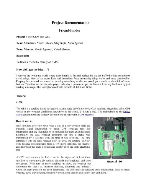
The GPS module provided to us was Quectel l10 .<br />
GSM:<br />
GSM (Global System for Mobile communication) is a digital mobile telephony system that is widely used in<br />
Europe and other parts of the world. GSM uses a variation of time division multiple access (TDMA) and is<br />
the most widely used of the three digital wireless telephony technologies (TDMA, GSM, and CDMA).<br />
GSM digitizes and compresses data, then sends it down a channel with two other streams of user data, each<br />
in its own time slot. It operates at either the 900 MHz or 1800 MHz frequency band.<br />
Using TDMA, a narrow band that is 30 kHz wide and 6.7<br />
milliseconds long is split time-wise into three time slots. Narrow<br />
band means channels in the traditional sense. Each conversation<br />
gets the radio for one-third of the time. This is possible because<br />
voice data that has been converted to digital information is<br />
compressed so that it takes up significantly less transmission<br />
space. Therefore, TDMA has three times the capacity of an<br />
analog system using the same number of channels.<br />
Hardware configuration:<br />
Major components used are:<br />
Atmega-16<br />
Max-232<br />
Quectel L10 GPSmodule<br />
I300 GSM module<br />
LCD<br />
MCU used is AtMega16 clocked to 12MHz.<br />
Clocking of ATMEGA using external Crystal Oscillator:
Simply attach the 12MHz Crystal Oscillator to the 12 th and 13 th pin of Atmega16 i.e. XTAL1 and<br />
XTAL2.If CPU frequency is defined change it to the frequency of external crystal i.e. 12MHz and finally<br />
while programming the MCU through AVR Studio go into fuse setting choose EXT Crystal with<br />
maximum delay time and Program it.<br />
Interfacing the modem and microcontroller:<br />
The GPS module gives us the latitude and longitude of a<br />
particular position. To access these values these values are<br />
transferred to a microcontroller-atmega16 through a<br />
MAX232.Similarly the GSM module is interfaced with<br />
the atmega through a MAX.<br />
This communication between the module and MAX and<br />
MAX and Atmega takes place with the help of UART.<br />
Pin diagram for interfacing a microcontroller with a serial port through MAX 232<br />
The two atmega communicate with each other through SPI.
Using the GPS module:<br />
The gps module gives us data which we have to decode as per our requirement.<br />
A screenshot of the GPS data on the hyperterminal.<br />
Decoding of selected position sentences:<br />
The most important NMEA sentences include the GGA which provides the current Fix data, the RMC<br />
which provides the minimum gps sentences information, and the GSA which provides the Satellite status<br />
data.<br />
GGA - essential fix data which provide 3D location and accuracy data.
$GPGGA,123519,4807.038,N,01131.000,E,1,08,0.9,545.4,M,46.9,M,,*47<br />
Where:<br />
GGA<br />
Global Positioning System Fix Data<br />
123519 Fix taken at 12:35:19 UTC<br />
4807.038,N Latitude 48 deg 07.038' N<br />
01131.000,E Longitude 11 deg 31.000' E<br />
08 Number of satellites being tracked<br />
0.9 Horizontal dilution of position<br />
545.4,M Altitude, Meters, above mean sea level<br />
46.9,M Height of geoid (mean sea level) above WGS84<br />
ellipsoid<br />
We extracted the data from the GPS module to give us the latitude and longitude of a position.<br />
Further we used these values to calculate the distance between two points. For this purpose we used the<br />
HAVERSINE FORMULA.<br />
Haversine formula:<br />
a = sin²(Δlat/2) + cos(lat 1 ).cos(lat 2 ).sin²(Δlong/2)<br />
c = 2.arctan2(√a / √(1−a))<br />
d = R.c where R is earth’s radius (mean radius = 6,371km)<br />
( angles need to be in radians to pass to trig functions!)<br />
GSM:<br />
With the help of the GSM module we can communicate between two sim cards.<br />
GSM module working on the hyperterminal.
Commonly used commands for a GSM module:<br />
1) AT - This command is used to check communication between the module and the computer.<br />
For example,<br />
AT<br />
OK<br />
The command returns a result code OK if the computer (serial port) and module are connected properly. If<br />
any of module or SIM is not working, it would return a result code ERROR.<br />
2) +CMGF - This command is used to set the SMS mode. Either text or PDU mode can be selected by<br />
assigning 1 or 0 in the command.<br />
SYNTAX: AT+CMGF=<br />
0: for PDU mode<br />
1: for text mode<br />
The text mode of SMS is easier to operate but it allows limited features of SMS. The PDU (protocol data<br />
unit) allows more access to SMS services but the operator requires bit level knowledge of TPDUs. The<br />
headers and body of SMS are accessed in hex format in PDU mode so it allows availing more features.<br />
For example,<br />
AT+CMGF=1<br />
OK<br />
3) +CMGW - This command is used to store message in the SIM.<br />
SYNTAX: AT+CMGW=” Phone number”> Message to be stored Ctrl+z<br />
As one types AT+CMGW and phone number, ‘>’ sign appears on next line where one can type the message.<br />
Multiple line messages can be typed in this case. This is why the message is terminated by providing a<br />
‘Ctrl+z’ combination. As Ctrl+z is pressed, the following information response is displayed on the screen.<br />
+CMGW: Number on which message has been stored<br />
4) +CMGS - This command is used to send a SMS message to a phone number.<br />
SYNTAX: AT+CMGS= serial number of message to be send.<br />
As the command AT+CMGS and serial number of message are entered, SMS is sent to the particular SIM.<br />
For example,<br />
AT+CMGS=1<br />
OK<br />
5) ATD - This command is used to dial or call a number.<br />
SYNTAX: ATD(Enter)<br />
For example,<br />
ATD123456789<br />
6) ATA - This command is used to answer a call. An incoming call is indicated by a message ‘RING’<br />
which is repeated for every ring of the call. When the call ends ‘NO CARRIER’ is displayed on the screen.<br />
SYNTAX: ATA(Enter)<br />
As ATA followed by enter key is pressed, incoming call is answered.<br />
For example,<br />
RING<br />
RING<br />
ATA
7) ATH - This command is used to disconnect remote user link with the GSM module.<br />
SYNTAX: ATH (Enter)<br />
Integration of the various components:<br />
The GPS module gave us the latitude and longitude. This was channeled to the microcontroller through Max-<br />
232(UART). The decoding of NMEA data was done by Atmega16 which was programmed in AVR studio.<br />
The code was written in CVAVR.<br />
The GSM module was connected to atmega through Max-232. The microcontrollers communicate with each<br />
other through SPI.<br />
When a user sends a message his number is extracted. The GPS data from the first microcontroller is sent to<br />
the microcontroller connected with the modem and a reply is sent to the extracted number.<br />
Utility:<br />
<strong>Friend</strong> <strong>Finder</strong><br />
Vehicle Tracking<br />
Data Logging<br />
The Final Product<br />
Useful Links:<br />
http://www.gpsinformation.org/dale/nmea.htm<br />
http://www.movable-type.co.uk/scripts/latlong.html<br />
http://www.winsystems.com/reprints/GSM%20AT%20Commands%20Rev.C.pdf
Problems Faced:<br />
At first we started with a different idea in mind. Our project was to move a bot from an initial<br />
point to a final point using GPS values and sending the commands through GSM. But due to<br />
problems of inaccuracy we had to abandon that part. Finally we came up with a <strong>Friend</strong> <strong>Finder</strong><br />
which helps us to locate a friend by just sending a message.<br />
A word of thanks:<br />
I would specially like to thank my team mentors MOHIT AGARWAL and VATSAL SHARAN , Club<br />
Coordinators RUDRA PRATAP SUMAN, ANURAG DWIVEDI and NIKHIL GUPTA for guiding us during the<br />
summers and for helping us learn new things….