Conference proceedings - UT Proceedings
Conference proceedings - UT Proceedings
Conference proceedings - UT Proceedings

Create successful ePaper yourself
Turn your PDF publications into a flip-book with our unique Google optimized e-Paper software.
Contents<br />
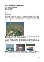
J. Aardoom - Creating a Current Atlas for the Port of Zeebrugge - - - - 5<br />
A. Armstrong - Towards New Standards of Competence for Hydrographers and Nautical Cartographers 11<br />
O. Cantrill - The CARIS Engineering Analysis Module - - - - - 17<br />
R.M. Capperucci Sediment vs Topographic micro Roughness - - - - - 23<br />
S. Claeys - Fluid mud density determination in navigational channels - - - 29<br />
C. Collins - The Progression of Multi-Dimensional Water Column Analysis - - 35<br />
R. Côté - Backscatter ”From Ping to Database” - - - - - 41<br />
M. Dauwe - Hydrographic Training in Belgium - - - - - - 45<br />
D. Depreiter - Flexible Disposal Strategy in the Scheldt Estuary - - - - 51<br />
T. van Dijk - Quantified sea-bed dynamics of the Netherlands Continental Shelf - - 57<br />
J. Dumollin - Inland Electronic Navigation Chart production - - - - 63<br />
J.B. Ferreira Fontes Deepening of the Port of Santos – Brazil - - - - - 69<br />
C. Gautier - Hydrodynamic Data from Radar Observations - - - - 75<br />
L. Gee - Is Multibeam Water Column Data Really Worth the Disk Space? - - 81<br />
S. Harper - New Data Quality Visualisation Methods in ECDIS - - - - 87<br />
P.T. Harris - From seafloor geomorphology to predictive habitat mapping - - - 93<br />
H. Hein - Computer-aided quality assurance of historic tide-gauge records - - 99<br />
T. Hiller - Measuring Bathymetric Uncertainty of the EdgeTech 4600 Sonar - - 105<br />
T. Hiller - Positioning Small AUVs for Deeper Water Surveys Using Inverted USBL - 111<br />
M. Hounjet - Accurate water levels using PREMO - - - - - 117<br />
M. Journault - High Precision Hydrography in Canada - - - - - 123<br />
N. Kinneging - River bed classification using multi-beam echo-sounder backscatter data - 129<br />
S. de Kleermaeker A New Coastal Flood Forecasting System for the Netherlands - - - 135<br />
J.K. Klippen - Source data collection, handling, management and integration - - - 141<br />
F. Köster - Integrated Bathymetric Data Management in the Port of Hamburg - - 147<br />
M. Kol - Determining rock quantities using swathe techniques on Maasvlakte 2 - - 153<br />
R. Longhorn - Assessing the Impact of INSPIRE on Related EU Marine Directives - - 159<br />
D. Mallace - Managing bathymetric data in a hydrographic survey company - - - 165<br />
R.M. Malyankar Digital Mariner’s Routeing Guide - - - - - - 177<br />
T. Mason - Beyond bathymetry - coastal marine mapping - - - - 183<br />
M. Mathys - A lithological and morphological map of the Lower Scheldt estuary - - 189<br />
M. van de Munt - INS aided subsurface positioning for ROV surveys - - - - 195<br />
S. Murthy - Recruiting and Training for the Future - - - - - 203<br />
H.O. Odunsi - Satellite remote sensing and coastal sediment monitoring - - - 209<br />
Y. Plancke - High resolution topo-bathymetric and flow measurements - - - 215<br />
B.M.J. Possel - Key Elements of Remote Offshore Survey Operations - - - - 223<br />
J. Pötrönen - High Resolution Multibeam Survey and Mobile Laser Scanning - - 229<br />
V. Putans - Sediment waves: geohazard or geofeature? - - - - - 233<br />
B. Ruesink - Innovative Positioning System Integration for Tunnel Construction - - 239<br />
S. Rütten - Results of operational sea-wave monitoring with radar gauges - - - 247<br />
S. Salter - How deep will the water be? - - - - - - 253<br />
L. Schiller - Comprehensive Definition and Systematic Subdivision of Hydrography - - 259<br />
N. Seube - Calibration of Vessel Mounted LiDAR - - - - - 265<br />
N. Seube - Hydrographic surveying course through international joint diplomas - - 277<br />
N. Seube - International Cooperation in Education: The VASSIVIERE Program 2011-2013 - 281<br />
C. Slobbe - Lowest Astronomical Tide in the North Sea - - - - - 289<br />
B. Spelt - The SBW field measurement program - - - - - 295<br />
E. Stuifbergen - Deep Water Dredging and Maintenance in the Offshore Industry - - 301<br />
R. Thain - Meeting professional standards through distance e-learning - - - 307<br />
D. Ventura - Utility of Airborne Lidar Bathymetry in Extreme Coastal Environments - - 311<br />
E. Verfaillie - The BLAST decision support system based on climate change - - - 319<br />
K. de Vries - Monitoring silt content in sediments off the Dutch Coast - - - 325<br />
C. Werner - Application of high resolution acoustics for fluid sediments - - - 331<br />
A.P. Wiersma - High-resolution geophysical survey in southern Kenya - - - 337<br />
A. de Wulf - Grid Models versus TIN: Geometric Accuracy of Multibeam Data Processing - 343<br />
Hydro12 | 3