MT Express Sample Low Resolution Issue ... - Monitoring Times
MT Express Sample Low Resolution Issue ... - Monitoring Times
MT Express Sample Low Resolution Issue ... - Monitoring Times

Create successful ePaper yourself
Turn your PDF publications into a flip-book with our unique Google optimized e-Paper software.
B<br />
OATS, PLANES, AND TRAINS<br />
Ron<br />
BOATS<br />
Walsh VE3GO<br />
ronwalsh@monitoringtimes.com<br />
Cold Weather, Hot DX<br />
VE3GO, here is November Eight<br />
Fitzgerald, N8F. You are 5 and 9 at the<br />
Whitefish Point Lighthouse. The handle<br />
is Ralph and the home call is KW8G.<br />
The N8F special event station commemorates<br />
the tragic loss of the Edmund<br />
Fitzgerald, on Nov. 10, 1975. She suddenly<br />
disappeared from radar screens during a hurricane<br />
force gale on Lake Superior. She was just 15 miles<br />
from the shelter of Whitefish Point. Ralph, KW8G,<br />
his daughter Laura, and others operate every year.<br />
I hope to be there and operate with them in the<br />
future.<br />
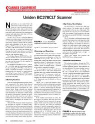
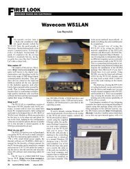
I took a picture of this vessel in 1958 when, as<br />
a 13year old passenger, I made a trip on the freighter<br />
Golden Hind, along with my parents. This was also<br />
where I first got to listen to marine radio.<br />
❖ Great Lakes Fall VHF Traffic<br />
I am reminded that this column will be read<br />
in January when the cold has set in to my part of<br />
the world and the short days (long nights) are more<br />
favorable to HF listening. The Seaway will be shut<br />
down, the local Coast Guard Search and Rescue base<br />
will be closed, the yachts will all be hauled out for<br />
the winter, the harbor will be frozen and the VHF<br />
traffic will be at a bare minimum.<br />
We have already had our first snowfall here and<br />
several gale warnings. The gales of November are<br />
famous on the lakes and hurricane force winds are<br />
not uncommon. There is a meeting of cold Arctic air<br />
and warm air from the Gulf of Mexico that produces<br />
cyclonic conditions right over the Great Lakes.<br />
The VHF radio here is very busy with traffic.<br />
Channels 11, 12, 13 and 14 are busy with vessel<br />
traffic information as the lakers try to get in end<br />
of season cargoes and the salt-water vessels scurry<br />
to avoid being caught in the lakes by freeze-up.<br />
We will soon have daily bulletins giving the water<br />
temperature, ice conditions and number of vessels<br />
above certain calling-in points. The race for the<br />
ocean will soon begin.<br />
In the Sault Ste. Marie area, monitor channels<br />
l2 and 16. These should be active along with the ship<br />
to ship channels when the icebreakers are needed for<br />
the Dec. and Jan passages of the locks. You might<br />
want to make a recording of the UCSG icebreaker<br />
Makinaw, as this is her last season to operate. The<br />
lockmaster is on channel 14 and water levels are<br />
supposed to be broadcast on channel 85 every two<br />
minutes.<br />
In the Niagara area (Welland Canal), monitor<br />
channels 11 and 14. In the Lake Ontario area,<br />
channel 11, 12 and 13 can be monitored. Channel<br />
13 is always a good one, as commercial vessels are<br />
required to monitor it. Ship to ship channels 6, 8 and<br />
10 are usually active as well. Channel 16 is always<br />
active, and the Canadian channels of 83B and 21B,<br />
along with the USCG channel of 21A, are the source<br />
of notices, weather etc.<br />
❖ Modern Marine<br />
Communications<br />
I just returned from a Simulated Electronic<br />
Navigation course at Georgian College in Owen<br />
Sound, Ontario. This was necessary for continued<br />
proficiency certification of my Master Minor Waters<br />
Certificate. Capt. Jim <strong>Low</strong>e put eight people from<br />
the local tour boats through three days of training<br />
and radar simulations. We were in simulators that<br />
replicated the bridge of a freighter. We had all the<br />
equipment, such as radio, radar, GPS charts, etc.,<br />
and were placed in a series of navigation situations.<br />
This marine college also teaches marine officers and<br />
engineers through a cadet program.<br />
They also teach the new Restricted Operator’s<br />
Certificate - Marine Commercial (ROC-MC), which<br />
is the radio license required for Canadian commercial<br />
marine officers on the great lakes and coastal<br />
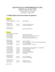
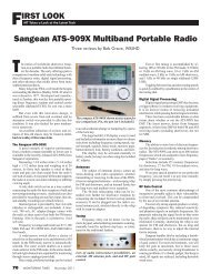
Simulated radio equipment for radio course.<br />
Clockwise L to R Dummy EPIRB, Waterproof<br />
VHF portable for survival craft, SART, Navtex<br />
receiver<br />
areas. We got to use some of this equipment, and I<br />
looked at the simulated equipment used for the ROC<br />
course.<br />
The course covers the usual VHF/HF radio<br />
information and procedures. However, it also covers<br />
the new GMDSS (Global Marine Distress and<br />
Safety System) material which all officers have to<br />
know. This includes DSC (Digital Selective Calling)<br />
Protocols and Distress Alerting, Navtex, NBDP<br />
(Narrow Band Direct Printing) for weather information,<br />
VHF Portable radios for survival craft, EPIRB<br />
(Emergency Position Indicating Radio Beacons and<br />
SART (Search and Rescue Transponders), among<br />
other items. I was particularly interested, as I teach<br />
the course for Marine Radio Restricted licenses<br />
for pleasure craft.<br />
Vessels going further off shore will also need<br />
people trained to use INMARSAT (International<br />
Marine Satellite). The EPIRB runs at 406 MHz and<br />
is usually triggered automatically in an emergency.<br />
The SART responds when it encounters X band<br />
(3 cm) radar transmissions at a range of about 8<br />
miles.<br />
I had an opportunity to witness the above<br />
training in real life when I took a very enjoyable<br />
cruise to Alaska aboard the Norwegian Sun this<br />
past summer. Just take a look at her electronic<br />
equipment list: She carries two complete HF/VHF<br />
radio systems, Navtex, three Comsat Satellite terminals,<br />
two satellite telex terminals, two SITOR<br />
telex terminals, three satellite facsimile lines,<br />
and two complete GMDSS Stations. This, along<br />
with many electronic aids such as GPS Navigator,<br />
VHF radio Direction Finder, and three ARPA<br />
(Automatic Radar Plotting Aid) radars, show how<br />
far electronics has come.<br />
Once DSC radios have become installed,<br />
the voice watch on channel 16 VHF (156.8 MHz)<br />
and 2182 kHz will no longer be mandatory on<br />
equipped vessels. However, in the coastal areas<br />
and Great Lakes there are many vessels that will<br />
not have to have such radios, so these frequencies<br />
will be monitored by Canadian Coast Guard<br />
radio stations for some time to come. The DCS<br />
alert frequencies are channel 70 VHF ( 156.525<br />
MHz) and 2187.5 kHz. I have begun to see many<br />
loggings on this HF frequency in various utility<br />
columns. The DSC VHF radios are coming down<br />
in price as I have seen several for sale for just over<br />
$200. They also can be connected to your GPS,<br />
so when the DSC call is made, geographical data<br />
can be sent.<br />
All ships in the St. Lawrence Seaway now<br />
have to carry an AIS system (Automatic Identification<br />
System) which uses radio signals and GPS<br />
data to relay your position and speed to the Seaway<br />
Authorities. This has produced some lively communications<br />
when ships are caught speeding in<br />
traffic control zones.<br />
❖ Information from Readers<br />
I received a request for a source for the<br />
VHF channel frequencies from Fred Fichman,<br />
WA6YVA. There are several places you can obtain<br />
these frequencies. There is usually a list with your<br />
marine transceiver and there are some web sites<br />
which also list them. A good site is http://www.<br />
marinewaypoints.com/learn/VHF.shtml The<br />
list gives the frequencies, channel numbers and<br />
the channel use. You can also get this information<br />
56 MONITORING TIMES January 2005