4 MAMMALIAN SPECIES 742—<strong>Thomomys</strong> <strong>bottae</strong> titude on Big Prospector Meadow, White Mountains, Mono County, California.’’ (113) T. b. mewa Merriam, 1908:146, see above. (114) T. b. minimus Durrant, 1939:161. Type locality ‘‘Stansbury Island, Great Salt Lake, Tooele County, Utah.’’ (115) T. b. minor Bailey, 1914:116. Type locality ‘‘Ft. Bragg, Mendocino Co., California.’’ (116) T. b. modicus Goldman, 1931:418. Type locality ‘‘La Osa (near Mexican Boundary), southern end of Altar Valley, Pima County, Arizona.’’ (117) T. b. mohavensis Grinnell, 1918:427. Type locality ‘‘Mohave River bottom, 2700 feet altitude, near Victorville, San Bernardino County, California.’’ (118) T. b. morulus Hooper, 1940:9. Type locality ‘‘New Mexico, Valencia County, eight miles southeast of Paxton, Bill Porter’s Ranch.’’ (119) T. b. muralis Goldman, 1936:112. Type locality ‘‘From lower end of Prospect Valley, Grand Canyon, Hualpai Indian Reservation, Arizona (altitude 4,500 feet).’’ (120) T. b. mutabilis Goldman, 1933a:75. Type locality ‘‘Camp Verde, Yavapai County, Arizona (altitude 3,200 feet).’’ (121) T. b. nanus Hall, 1932a:331. Type locality ‘‘south end of Belted Range, five and one-half miles northwest of Whiterock Spring, 7,200 feet altitude, Nye County, Nevada.’’ (122) T. b. nasutus Hall, 1932d:96. Type locality ‘‘west fork of Black River, 7550 feet altitude, Apache County, Arizona.’’ (123) T. b. navus Merriam, 1901:112. Type locality ‘‘Red Bluff, California.’’ (124) T. b. neglectus Bailey, 1914:117. Type locality ‘‘San Antonio Peak (Bear Flat Meadows at 6400 feet altitude) in the San Gabriel Mountains, California.’’ (125) T. b. nesophilus Durrant, 1936:2. Type locality ‘‘Antelope Island, Great Salt Lake, Davis County, Utah.’’ (126) T. b. nicholi Goldman, 1938b:337. Type locality ‘‘from 20 miles south of Wolf Hole (road to Parashouts), Shivwits Plateau, Mohave County, Arizona (altitude 5,000 feet.)’’ (127) T. b. nigricans Rhoads, 1895:36. Type locality ‘‘Witch Creek, San Diego Co., California.’’ (128) T. b. operarius Merriam, 1897:215, see above. (129) T. b. operosus Hatfield, 1942:151. Type locality ‘‘6 mi. N. Yarnell (Peeples Valley), Yavapai Co., Arizona.’’ (130) T. b. optabilis Goldman, 1936:116. Type locality ‘‘Coventry, Naturita Creek Valley, Montrose County, Colorado (altitude 6,500 feet).’’ (131) T. b. opulentus Goldman, 1935:150. Type locality ‘‘Las Palomas, on the Rio Grande, Sierra County, New Mexico.’’ (132) T. b. oreoecus Burt, 1932:154, see above. (133) T. b. osgoodi Goldman, 1931:424. Type locality ‘‘Hanksville, Wayne County, Utah.’’ (134) T. b. paguatae Hooper, 1940:4. Type locality ‘‘New Mexico, Valencia County, one-half mile north of Cebolleta [Seboyeta Post Office].’’ (135) T. b. pallescens Rhoads, 1895:36. Type locality ‘‘Grapelands, San Bernardino Valley, California.’’ (136) T. b. parvulus Goldman, 1938b:339. Type locality ‘‘pass between Santa Catalina and Rincon Mountains, Pima County, Arizona (altitude 4,500 feet).’’ (137) T. b. pascalis Merriam, 1901:111. Type locality ‘‘Fresno, San Joaquin Valley, California.’’ (138) T. b. patulus Goldman, 1938b:341. Type locality ‘‘bottomland along Hassayampa River, two miles below Wickenburg, Maricopa County, Arizona (altitude, 2,000 feet).’’ (139) T. b. pectoralis Goldman, 1936:120. Type locality ‘‘from vicinity of Carlsbad Cave, Carlsbad Cave National Monument, Eddy County, New Mexico.’’ (140) T. b. peramplus Goldman, 1931:423. Type locality ‘‘Wheatfield Creek, west slope of Tunicha Mountains, Apache County, northwestern Arizona (altitude 7,000 feet).’’ (141) T. b. perpallidus Merriam, 1886:588. Type locality ‘‘the arid Colorado desert, in southern California.’’ Reported as ‘‘Palm Springs [formerly Agua Caliente, Riverside County, Calif.]’’ by Miller and Kellogg (1955:284). (142) T. b. perpes Merriam, 1901:111. Type locality ‘‘Lone Pine, Owens Valley, California.’’ (143) T. b. pervagus Merriam, 1901:110. Type locality ‘‘Espaniola, New Mexico.’’ (144) T. b. pervarius Goldman, 1938a:57. Type locality ‘‘Lloyd Ranch, 35 miles south of Marfa, Presidio County, Texas (altitude 4,200 feet).’’ (145) T. b. phasma Goldman, 1933a:72. Type locality ‘‘two miles south of Tule Tank, Tule Desert, near Mexican boundary, Yuma County, Arizona.’’ (146) T. b. phelleoecus Burt, 1933:56, see above. (147) T. b. pinalensis Goldman, 1938b:342. Type locality ‘‘Oak Flat, 5 miles east of Superior, Pinal Mountains, Arizona.’’ (148) T. b. piutensis Grinnell and Hill, 1936b:103. Type locality ‘‘French Gulch, Piute Mountains, altitude 6700 feet, 2 ½ miles northwest Claraville, Kern County, California.’’ (149) T. b. planirostris Burt, 1931:38. Type locality ‘‘Zion National Park, Washington County, Utah.’’ (150) T. b. planorum Hooper, 1940:5. Type locality ‘‘New Mexico, Valencia County, one and one-half miles southwest of San Mateo.’’ (151) T. b. powelli Durrant, 1955:79. Type locality ‘‘Hall Ranch, Salt Gulch, 8 miles west of Boulder, 6,000 feet, Garfield County, Utah.’’ (152) T. b. providentialis Grinnell, 1931:1. Type locality ‘‘Purdy, 4,500 feet altitude, 6 miles southeast of New York Mountain, Providence Range, San Bernardino County, California.’’ (153) T. b. proximarinus Huey, 1945:261. Type locality ‘‘Boca la Playa, 16 miles west of Santo Tomás, Baja California, Mexico (mesa bordering the sea), lat. 3132N, long. 11638W.’’ (154) T. b. proximus Burt and Campbell, 1934:151. Type locality ‘‘Old Parker Ranch (Picketts Ranch on U.S. Geological Survey topographic map, Patagonia Quadrangle, edition of August, 1905), altitude 4800 feet, west slope of Santa Rita Mountains, Pima County, Arizona.’’ (155) T. b. puertae Grinnell, 1914:315. Type locality ‘‘La Puerta (Mason’s Ranch), eastern San Diego County, California.’’ (156) T. b. pusillus Goldman, 1931:422. Type locality ‘‘Coyote Mountains, Pima County, Arizona (altitude 3,000 feet).’’ (157) T. b. retractus Baker, 1953:507. Type locality ‘‘Fortín, 3,300 ft., 33 mi. N and 1 mi. E San Gerónimo, Coahuila.’’ (158) T. b. rhizophagus Huey, 1949:54. Type locality ‘‘Las Flores, 7 miles south of Bahía de Los Angeles, Baja California, Mexico, lat. 2850N., long. 11332W.’’ (159) T. b. riparius Grinnell and Hill, 1936a:4. Type locality ‘‘Blythe, Riverside County, California.’’ (160) T. b. robustus Durrant, 1946:30. Type locality ‘‘Orr’s Ranch, Skull Valley, 4,300 ft., Tooele County, Utah.’’ (161) T. b. rubidus Youngman, 1958:376. Type locality ‘‘2 9/10 miles east of Cañon City, 5344 feet, Fremont County, Colorado.’’ (162) T. b. rufidulus Hoffmeister, 1955:126. Type locality ‘‘2 miles east of Joseph City, Navajo County, Ariz.’’ (163) T. b. ruidosae Hall, 1932d:96. Type locality ‘‘Ruidoso, 6700 feet altitude, Lincoln County, New Mexico.’’ (164) T. b. rupestris Chattin, 1941:272. Type locality ‘‘1,131 ft., 2 mi. E Clemens Well, Riverside County, California.’’ (165) T. b. ruricola Huey, 1949:53. Type locality ‘‘4 miles north of Santa Catarina Landing, Baja California, Mexico, lat. 2935N, long. 11517W.’’ (166) T. b. russeolus Nelson and Goldman, 1909:25. Type locality ‘‘San Angel, 30 miles west of San Ignacio, Lower California, Mexico,’’ Baja California Sur. (167) T. b. sanctidiegi Huey, 1945:258. Type locality Balboa Park, San Diego, California. (168) T. b. saxatilis Grinnell, 1934:193. Type locality ‘‘open, rocky, uncultivated ground, one mile north of Susanville, at 4400 feet altitude, Lassen County, California.’’ (169) T. b. scapterus Elliot, 1903b:224. Type locality ‘‘Lone Pine, Owens Valley, Inyo County, California.’’ (170) T. b. scotophilus Davis, 1940:204. Type locality ‘‘one and one-half miles west of Bat Cave, Sierra Diablo, Hudspeth County, Texas.’’ (171) T. b. sevieri Durrant, 1946:45. Type locality ‘‘Swasey Spring, House Mountains, 6,500 ft., Millard County, Utah.’’ (172) T. b. siccovallis Huey, 1945:258. Type locality ‘‘El Cajón Canyon, 3,200 feet altitude, east base of Sierra San Pedro Mártir, Baja California, Mexico, lat. 3054N; long. 11510W.’’ (173) T. b. silvifugus Grinnell, 1935:406. Type locality ‘‘near Coyote Peak, at 3000 feet altitude, Humboldt County, California.’’ (174) T. b. simulus Nelson and Goldman, 1934:120, see above. (175) T. b. sinaloae Merriam, 1901:108, see above. (176)
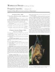
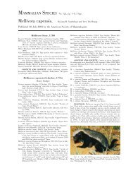
742—<strong>Thomomys</strong> <strong>bottae</strong> MAMMALIAN SPECIES 5 T. b. solitarius Grinnell, 1926:177. Type locality ‘‘Finger-rock Wash, Stewart Valley, 5400 feet altitude, Mineral County, Nevada.’’ (177) T. b. spatiosus Goldman, 1938a:58. Type locality ‘‘Alpine, Brewster County, Texas (altitude about 4,500 feet).’’ (178) T. b. stansburyi Durrant, 1946:36. Type locality ‘‘South Willow Creek, Stansbury Mountains, 7,500 ft., Tooele County, Utah.’’ (179) T. b. sturgisi Goldman, 1938a:56, see above. (180) T. b. suboles Goldman, 1928:203. Type locality ‘‘from alluvial bottom at Old Searchlight Ferry, Colorado River (northwest of Kingman), Arizona (altitude 1,000 feet).’’ (181) T. b. subsimilis Goldman, 1933a:74. Type locality ‘‘Harquahala Mountains, Yuma County, Arizona (altitude 3,000 feet).’’ (182) T. b. texensis Bailey, 1902:119. Type locality ‘‘the head of Limpia Creek at 5,500 feet altitude in the Davis Mts., Texas.’’ (183) T. b. tivius Durrant, 1937:5. Type locality ‘‘Oak Creek Canyon, 6 miles east Oak City, 6,000 feet, Millard County, Utah.’’ (184) T. b. toltecus Allen, 1893:52, see above. (185) T. b. trumbullensis Hall and Davis, 1934:51. Type locality ‘‘three miles south of Nixon Spring, Mt. Trumbull, Mohave Co., Arizona.’’ (186) T. b. tularosae Hall, 1932b:411. Type locality ‘‘Cook Ranch, ½ mile west of Tularosa, Otero County, New Mexico.’’ (187) T. b. vanrossemi Huey, 1934:1. Type locality ‘‘Punta Peñascosa, Sonora, Mexico.’’ (188) T. b. varus Hall and Long, 1960:35. Type locality ‘‘1 mi. S El Dorado, Sinaloa, México.’’ (189) T. b. vescus Hall and Davis, 1935:389. Type locality ‘‘Toquima Range, S slope Mount Jefferson, 9,000 ft. altitude, Nye County, Nevada.’’ (190) T. b. villai Baker, 1953:505. Type locality ‘‘7 mi. S and 2 mi. E Boquillas, 1800 ft., Coahuila.’’ (191) T. b. virgineus Goldman, 1937a:133. Type locality ‘‘Beaverdam Creek, near confluence with Virgin River, at Littlefield, northwestern Arizona (altitude 1,500 feet).’’ (192) T. b. wahwahensis Durrant, 1937:3. Type locality ‘‘Wah Wah Springs, 30 miles west of Milford, 6500 feet, Beaver County, Utah.’’ (193) T. b. winthropi Nelson and Goldman, 1934:122. Type locality ‘‘Hermosillo, Sonora, Mexico.’’ (194) T. b. xerophilus Huey, 1945:257. Type locality ‘‘near Diablito Spring, summit of San Matias Pass (between Sierra Juárez and Sierra San Pedro Mártir), Baja California, Mexico.’’ (195) DIAGNOSIS. Characteristics of the subgenus Megascapheus (containing T. <strong>bottae</strong>) that separate it from the subgenus <strong>Thomomys</strong> include a heavy rostrum; base of P4 inclined anteriorly, base of incisor between bases of P4 and M1; infraorbital canals opening anterior to incisive foramina; open sphenoid fissure; anterior enamel plate of p4 narrow and not recurved (Thaeler 1980). Separation of T. <strong>bottae</strong> from T. townsendii and from T. umbrinus is problematic. Botta’s pocket gopher is best distinguished near zones of contact by a combination of characters, including color (generally lacking a prominent medial black stripe); moderately procumbent incisors; slightly tapering nasals with gradually narrowing posterior ends; straight pterygoid processes; concave maxillofrontal suture articulating near center of lacrimal; 2 pairs of pectoral mammae; long, straight shape of baculum (averaging 10.5 mm); and fewer acrocentric autosomes in the karyotype (Dunnigan 1967; Hoffmeister 1986; Patton 1973, 1999a; Patton et al. 1984; Thaeler 1968b). FIG. 2. Dorsal, ventral, and lateral views of cranium and lateral view of mandible of <strong>Thomomys</strong> <strong>bottae</strong> (adult female, Denver Museum of Nature and <strong>Science</strong>, DMNH 8528) from Las Animas County, Colorado. Greatest length of cranium is 37.9 mm. By Eric Parrish. GENERAL CHARACTERS. <strong>Thomomys</strong> <strong>bottae</strong> has a fusiform body, large head, robust claws, and loose skin (Fig. 1). Pelage consists of fine, moderately-long hairs with scattered guard hairs (Hill 1937). Pelage color relates to soil color and moisture gradients (Benson 1933; Getz 1957; Goldman 1947; Ingles 1950; Patton 1973; Patton and Smith 1990). Hair follicles grow through dermis and contact underlying paniculus carnosus muscles. Hair length and density of follicles is greater in winter than in summer and might be greater in females (Morejohn and Howard 1956). Dorsal pelage color is extremely variable geographically; color (especially brightness) is 1 characteristic used to recognize subspecies (Patton and Smith 1990). In some populations hair color changes seasonally (Morejohn and Howard 1956). Cranial features (Fig. 2) include a presphenoid foramen, separation of optic foramen and sphenoidal fissure, confluence of foramina ovale and lacerum, vestigial vascular canal, and absence of stapedial foramen (Hill 1935). Skull has a broad rostrum with slightly tapered nasals narrowing posteriorly; heavy zygomata with prominent external angles near sutures with jugal; interparietals not extending posteriorly beyond plane of sutures between parietals and supraoccipital; and broad, decurved, upper incisors (Goldman 1947). Sexual dimorphism varies geographically and is primarily associated with sizes of males. Males continue to grow with age, whereas growth of females ends as they become reproductive (Howard and Childs 1959; Patton 1993c; Patton and Smith 1990). Growth rates are related closely to nutrition (Patton and Brlylski 1987; Patton and Smith 1990). Cranial shape is probably more