Thomomys bottae - Clark Science Center
Thomomys bottae - Clark Science Center
Thomomys bottae - Clark Science Center

Create successful ePaper yourself
Turn your PDF publications into a flip-book with our unique Google optimized e-Paper software.
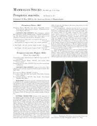
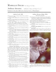
742—<strong>Thomomys</strong> <strong>bottae</strong><br />
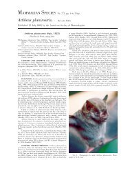
MAMMALIAN SPECIES 3<br />
T. b. cinereus Hall, 1932a:327. Type locality ‘‘West Walker River,<br />
Smiths Valley, 4700 feet altitude, Lyon County, Nevada.’’ (52)<br />
T. b. collinus Goldman, 1931:421. Type locality ‘‘Fly Park, Chiricahua<br />
Mountains, Cochise County, Arizona (altitude 9,000<br />
feet).’’ (53)<br />
T. b. collis Hooper, 1940:7. Type locality ‘‘New Mexico, Valencia<br />
County, thirty miles south of Grants, Shuman’s Ranch, township<br />
6 north, range 10 west, section 30.’’ (54)<br />
T. b. comobabiensis Huey, 1937:354. Type locality ‘‘5 miles northwest<br />
of Sells, Pima County, Arizona (elevation, approximately<br />
2400 feet).’’ (55)<br />
T. b. concisor Hall and Davis, 1935:390. Type locality ‘‘Potts<br />
Ranch, 6900 ft., Monitor Valley, Nye County, Nevada.’’ (56)<br />
T. b. confinalis Goldman, 1936:119. Type locality ‘‘35 miles east<br />
of Rock Springs, Texas (altitude 2,450 feet).’’ (57)<br />
T. b. connectens Hall, 1936:296. Type locality ‘‘Clawson Dairy, 5<br />
miles north of Albuquerque, 4,943 feet elevation, Bernalillo<br />
County, New Mexico.’’ (58)<br />
T. b. contractus Durrant, 1946:50. Type locality ‘‘Scipio, 5,315 ft.,<br />
Millard County, Utah.’’ (59)<br />
T. b. convergens Nelson and Goldman, 1934:123. Type locality ‘‘Costa<br />
Rica Ranch, delta of Sonora River, southwest of Hermosillo,<br />
Sonora, Mexico.’’ (60)<br />
T. b. convexus Durrant, 1939:159. Type locality ‘‘E. side Clear<br />
Lake, 4,600 ft., Millard County, Utah.’’ (61)<br />
T. b. crassus Chattin, 1941:274. Type locality ‘‘180 ft., 1 ½ mi. W<br />
Niland, Imperial County, California.’’ (62)<br />
T. b. cultellus Kelson, 1951:64. Type locality ‘‘Halls Peak, Mora<br />
County, New Mexico.’’ (63)<br />
T. b. cunicularis Huey, 1945:252. Type locality ‘‘Los Palmitos<br />
(western end of Pattie Basin), on the southeastern base of the<br />
Sierra Juárez (desert slope), latitude 3144N., longitude<br />
11536W., Baja California, Mexico.’’ (64)<br />
T. b. curtatus Hall, 1932a:329. Type locality ‘‘San Antonio, 5400<br />
feet altitude, Nye County, Nevada.’’ (65)<br />
T. b. depauperatus Grinnell and Hill, 1936a:4. Type locality ‘‘east<br />
base Tinajas Atlas Mountains, 7 miles south of Raven Butte,<br />
1150 feet altitude, Yuma County, Arizona.’’ (66)<br />
T. b. depressus Hall, 1932a:326. Type locality ‘‘Dixie Meadows [at<br />
south end of Humboldt Salt Marsh], 3,500 feet altitude, Churchill<br />
County, Nevada.’’ (67)<br />
T. b. desertorum Merriam, 1901:114, see above. (68)<br />
T. b. desitus Goldman, 1936:113. Type locality ‘‘Big Sandy River,<br />
near Owen, Mohave County, Arizona (altitude 2,000 feet).’’<br />
(69)<br />
T. b. detumidus Grinnell, 1935:405. Type locality ‘‘open grassy<br />
hillside, 250 feet altitude, 1½ miles south of (town of) Pistol<br />
River, Curry County, Oregon.’’ (70)<br />
T. b. diaboli Grinnell, 1914:313, see above. (71)<br />
T. b. dissimilis Goldman, 1931:425. Type locality ‘‘east slope of<br />
Mount Ellen, Henry Mountains, Garfield County, Utah (altitude<br />
8,000 feet).’’ (72)<br />
T. b. divergens Nelson and Goldman, 1934:122. Type locality ‘‘four<br />
miles west of Huachinera, Bavispe River, northeastern Sonora,<br />
Mexico (altitude about 4,000 feet).’’ (73)<br />
T. b. estanciae Benson and Tillotson, 1939:152. Type locality ‘‘La<br />
Estancia, 6 miles north of Nacori, Sonora.’’ (74)<br />
T. b. extenuatus Goldman, 1935:149. Type locality ‘‘Willcox, Cochise<br />
County, Arizona (altitude 4,000 feet).’’ (75)<br />
T. b. flavidus Goldman, 1931:417. Type locality ‘‘Parker, Yuma<br />
County, Arizona (altitude 350 feet).’’ (76)<br />
T. b. fulvus Woodhouse, 1852:201. Type locality ‘‘near the San<br />
Francisco Mountain, New Mexico.’’ (77)<br />
T. b. fumosus Hall, 1932a:329. Type locality ‘‘Milman Ranch,<br />
Moores Creek, 19 miles southeast of Millett P.O., Nye County,<br />
Nevada.’’ (78)<br />
T. b. grahamensis Goldman, 1931:420. Type locality ‘‘Graham<br />
Mountains (Pinaleno Mountains on some maps) Graham County,<br />
Arizona (altitude 9,200 feet).’’ (79)<br />
T. b. growlerensis Huey, 1937:353. Type locality ‘‘7 miles east of<br />
Papago Well, Pima County, Arizona (or, exactly, along a well<br />
wooded desert wash on the southwestern side of a range of<br />
hills in the southern end of Growler Valley; the Agua Dulce<br />
Mountains form the southern boundary of this locality and are<br />
not far distant).’’ (80)<br />
T. b. guadalupensis Goldman, 1936:117. Type locality ‘‘McKittrick<br />
Canyon, Guadalupe Mountains, Texas (altitude 7,800 feet).’’<br />
(81)<br />
T. b. harquahalae Grinnell and Hill, 1936a:7. Type locality ‘‘Ranegras<br />
Plain, 10 miles west of Hope, Yuma County, Arizona;<br />
altitude approximately 950 ft.’’ (82)<br />
T. b. homorus Huey, 1949:55. Type locality ‘‘1 mile east of Rancho<br />
Lagunitas, Baja California, Mexico, lat. 2820N., long.<br />
11315W.’’ (83)<br />
T. b. howelli Goldman, 1936:116. Type locality, ‘‘Grand Junction,<br />
Mesa County, Colorado (altitude 4,600 feet).’’ (84)<br />
T. b. hualpaiensis Goldman, 1936:114. Type locality ‘‘Hualpai<br />
Peak, Hualpai Mountains, Mohave County, Arizona (altitude<br />
7,000 feet).’’ (85)<br />
T. b. hueyi Goldman, 1938b:340. Type locality ‘‘Spud Rock Ranger<br />
Station, Rincon Mountains, Pima County, Arizona (altitude<br />
7,400 feet).’’ (86)<br />
T. b. humulis Baker, 1953:503. Type locality ‘‘3 mi. W Had. [Hacienda]<br />
San Miguel, 2,200 ft., Coahuila.’’ (87)<br />
T. b. imitabilis Goldman, 1939:30. Type locality ‘‘La Paz, southern<br />
Lower California, Mexico,’’ Baja California Sur. (88)<br />
T. b. incomptus Goldman, 1939:29. Type locality ‘‘San Jorge, near<br />
Pacific coast west of Pozo Grande and about 25 miles southwest<br />
of Comondú, southern Lower California, Mexico (altitude<br />
50 feet).’’ (89)<br />
T. b. infrapallidus Grinnell, 1914:314, see above. (90)<br />
T. b. ingens Grinnell, 1932:405. Type locality ‘‘east side levee, 290<br />
feet altitude (2 miles due west of Millux, as shown on U.S.G.S.<br />
‘‘Buena Vista Lake Quadrangle’’), Buena Vista Lake, Kern<br />
County, California.’’ (91)<br />
T. b. internatus Goldman, 1936:115. Type locality ‘‘Salida, Chaffee<br />
County, Colorado (altitude 7,000 feet).’’ (92)<br />
T. b. jacinteus Grinnell and Swarth, 1914:154. Type locality<br />
‘‘Round Valley, 9000 feet altitude, San Jacinto Mountains,<br />
Riverside County, California.’’ (93)<br />
T. b. jojobae Huey, 1945:256. Type locality ‘‘Sangre de Cristo, Baja<br />
California, Mexico, lat. 3151N.; long. 11606W.’’ (94)<br />
T. b. juarezensis Huey, 1945:255. Type locality ‘‘Laguna Hanson,<br />
Sierra Juárez, Baja California, Mexico.’’ (95)<br />
T. b. lachuguilla Bailey, 1902:120. Type locality ‘‘arid foothills<br />
near El Paso, Texas.’’ (96)<br />
T. b. lacrymalis Hall, 1932a:328. Type locality ‘‘Arlemont [ Chiatovich<br />
Ranch, Fish Lake Valley], 4900 feet altitude, Esmeralda<br />
County, Nevada.’’ (97)<br />
T. b. laticeps Baird, 1856:335. Type locality ‘‘Humboldt Bay’’ California.<br />
(98)<br />
T. b. latirostris Merriam, 1901:107, see above. (99)<br />
T. b. latus Hall and Davis, 1935:393. Type locality ‘‘Cherry Creek,<br />
6500 ft., White Pine County, Nevada.’’ (100)<br />
T. b. lenis Goldman, 1942:75. Type locality ‘‘Richfield, Sevier<br />
County, Utah.’’ (101)<br />
T. b. leucodon Merriam, 1897:215, see above. (102)<br />
T. b. levidensis Goldman, 1942:76. Type locality ‘‘Manti, Sanpete<br />
County, Utah (altitude about 5,500 feet).’’ (103)<br />
T. b. limitaris Goldman, 1936:118. Type locality ‘‘four miles west<br />
of Boquillas, Brewster County, Texas.’’ (104)<br />
T. b. limpiae Blair, 1939:2. Type locality ‘‘Limpia Canyon, about<br />
one mile north of Fort Davis, Jeff Davis County, Texas; altitude,<br />
4,700 feet.’’ (105)<br />
T. b. litoris Burt, 1940:1. Type locality ‘‘Stearns Point, Magalena<br />
Bay (west side), Lower California, Mexico,’’ Baja California<br />
Sur. (106)<br />
T. b. lorenzi Huey, 1940:219. Type locality ‘‘7 miles north of Boulder<br />
Creek, Santa Cruz County, California.’’ (107)<br />
T. b. lucidus Hall, 1932c:67. Type locality ‘‘Las Palmas Cañon, 200<br />
feet altitude, west side of Laguna Salada (north of 32N. latitude),<br />
Lower California, Mexico,’’ 2 miles east of Gaskill’s<br />
Tanks, Baja California (Patton 1999a). (108)<br />
T. b. lucrificus Hall and Durham, 1938:15. Type locality ‘‘Eastgate,<br />
Churchill County, Nevada.’’ (109)<br />
T. b. magdalenae Nelson and Goldman, 1909:24, see above. (110)<br />
T. b. martirensis Allen, 1898:147. Type locality ‘‘San Pedro Martir<br />
Mountains (alt. 8200 feet), Lower California,’’ La Grulla<br />
Meadow, Sierra San Pedro Martir, 7400 feet, Baja California<br />
(Patton 1999a). (111)<br />
T. b. mearnsi Bailey, 1914:117. Type locality ‘‘Gray’s Ranch in Animas<br />
Valley, southwest corner of New Mexico.’’ (112)<br />
T. b. melanotis Grinnell, 1918:425. Type locality ‘‘10,500 feet al-