Thomomys bottae - Clark Science Center
Thomomys bottae - Clark Science Center
Thomomys bottae - Clark Science Center

You also want an ePaper? Increase the reach of your titles
YUMPU automatically turns print PDFs into web optimized ePapers that Google loves.
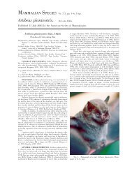
2 MAMMALIAN SPECIES 742—<strong>Thomomys</strong> <strong>bottae</strong><br />
<strong>Thomomys</strong> magdalenae Nelson and Goldman, 1909:24. Type locality<br />
‘‘Magdalena Island, Lower California, Mexico,’’ Baja<br />
California Sur.<br />
<strong>Thomomys</strong> canus Bailey, 1910:79. Type locality ‘‘Deep Hole, at<br />
north end of Smoke Creek Desert, Nevada.’’<br />
<strong>Thomomys</strong> diaboli Grinnell, 1914:313. Type locality ‘‘Sweeney’s<br />
Ranch, in hills of Diablo Range twenty-two miles south of Los<br />
Baños, Merced County, California.’’<br />
<strong>Thomomys</strong> infrapallidus Grinnell, 1914:314. Type locality ‘‘seven<br />
miles southeast of Simmler, Carrizo Plain, San Luis Obispo<br />
County, California.’’<br />
<strong>Thomomys</strong> oreoecus Burt, 1932:154. Type locality ‘‘Greenwater<br />
[Black Mountains, eight miles southwest of Ryan], Inyo County,<br />
California; altitude 4,300 feet.’’<br />
<strong>Thomomys</strong> phelleoecus Burt, 1933:56. Type locality ‘‘Hidden Forest,<br />
Sheep Mountains, <strong>Clark</strong> County, Nevada; altitude 8,500<br />
feet.’’<br />
<strong>Thomomys</strong> simulus Nelson and Goldman, 1934:120. Type locality<br />
‘‘Alamos, southern Sonora, Mexico (altitude 1,200 feet).’’<br />
<strong>Thomomys</strong> sturgisi Goldman, 1938a:56. Type locality ‘‘Carmen<br />
Mountains, Coahuila, Mexico (altitude 6,000 feet).’’<br />
CONTEXT AND CONTENT. Context as for genus, subgenus<br />
Megascapheus (Patton 1993a). One of 4 species in the subgenus<br />
(Patton 1993a). Species boundaries within <strong>Thomomys</strong> are<br />
complex; T. <strong>bottae</strong> was 1 of 3 species (with townsendii and umbrinus)<br />
combined within T. umbrinus by Hall and Kelson (1959)<br />
and Hall (1981), leading to use of T. umbrinus for this taxon until<br />
the 1980s. Confusion regarding species boundaries was addressed<br />
by Patton (1973), Patton and Dingman (1970), and Patton and<br />
Smith (1981, 1990, 1994). Almost 50% of the 195, formally recognized<br />
subspecies are from Baja California, Arizona, and Nevada<br />
(Goldman 1947; Hall and Davis 1935; Huey 1964; Patton 1999a).<br />
Parenthetical numbers refer to distribution map.<br />
T. b. abbotti Huey, 1928:89. Type locality ‘‘1 mile east of El Rosario,<br />
Lower California, Mexico (river-bottom association), lat.<br />
3003north, long. 11548W,’’ Baja California.’’ (1)<br />
T. b. absonus Goldman, 1931:425. Type locality ‘‘Jacob’s Pools,<br />
Houserock Valley, Coconino County, northern Arizona (altitude<br />
4,000 feet).’’ (2)<br />
T. b. abstrusus Hall and Davis, 1935:391. Type locality ‘‘Fish Spring<br />
Valley, 2 mi. SE Tulle Peak, 7,000 ft., Nye County, Nevada.’’<br />
(3)<br />
T. b. acrirostratus Grinnell, 1935:408. Type locality ‘‘valley of Mad<br />
River at 2,700 feet altitude, 7 miles above Ruth, Trinity County,<br />
California.’’ (4)<br />
T. b. actuosus Kelson, 1951:67. Type locality ‘‘Corona, Lincoln<br />
County, New Mexico.’’ (5)<br />
T. b. aderrans Huey, 1939:71. Type locality ‘‘Carrizo Creek, San<br />
Diego County, California.’’ (6)<br />
T. b. affinis Huey, 1945:254. Type locality ‘‘Jacumba, San Diego<br />
County, California.’’ (7)<br />
T. b. agricolaris Grinnell, 1935:409. Type locality ‘‘Stralock Farm,<br />
3 miles west of Davis, Yolo County, California.’’ (8)<br />
T. b. albatus Grinnell, 1912:172. Type locality ‘‘California side of<br />
the lower Colorado River at the old Hanlon Ranch, near Pilot<br />
Knob, Imperial County.’’ (9)<br />
T. b. albicaudatus Hall, 1930:444. Type locality ‘‘Provo, 4,510 feet<br />
altitude, Utah County, Utah.’’ (10)<br />
T. b. alexandrae Goldman, 1933b:464. Type locality ‘‘plain 5 miles<br />
southeast of Rainbow Lodge, near Navajo Mountain, Coconino<br />
County, Arizona (altitude 6,200 feet).’’ (11)<br />
T. b. alienus Goldman, 1938b:338. Type locality ‘‘Mammoth, San<br />
Pedro River, Pinal County, Arizona (altitude 2,400 feet).’’ (12)<br />
T. b. alpinus Merriam, 1897:216. Type locality ‘‘Mt. Whitney, High<br />
Sierra, California. Exact locality, Big Cottonwood Meadows<br />
(altitude, 10,000 feet, 8 miles SE. of Mt. Whitney peak.’’ (13)<br />
T. b. alticolus Allen, 1899:14. Type locality ‘‘Sierra Laguna (altitude<br />
7,000 feet), Lower California,’’ Baja California Sur. (14)<br />
T. b. altivallis Rhoads, 1895:34. Type locality ‘‘San Bernardino<br />
Mts., California (alt. 5,000 ft.).’’ (15)<br />
T. b. amargosae Grinnell, 1921:239. Type locality ‘‘Shoshone,<br />
1560 feet altitude on the Amargosa ‘‘River,’’ Inyo County, California.’’<br />
(16)<br />
T. b. analogus Goldman, 1938a:59. Type locality ‘‘Sierra Guadalupe,<br />
southeastern Coahuila, Mexico.’’ (17)<br />
T. b. angularis Merriam, 1897:214, see above. (18)<br />
T. b. angustidens Baker, 1953:508. Type locality ‘‘Sierra del Pino,<br />
5,250 ft., 6 mi. N and 6 mi. W Acebuches, Coahuila.’’ (19)<br />
T. b. anitae Allen, 1898:146. Type locality ‘‘Santa Anita, Lower<br />
California,’’ Baja California Sur. (20)<br />
T. b. apache Bailey, 1910:79. Type locality ‘‘Lake La Jara (7,500<br />
feet altitude), on the Jicarilla Apache Indian Reservation, New<br />
Mexico.’’ (21)<br />
T. b. aphrastus Elliot, 1903b:219. Type locality ‘‘San Tomás, Lower<br />
California, Mexico,’’ Baja California. (22)<br />
T. b. aridicola Huey, 1937:354. Type locality ‘‘10 miles south of<br />
Gila Bend (or, exactly, on Ajo railroad right of way, about 2<br />
miles north of Black Gap), Maricopa County, Arizona.’’ (23)<br />
T. b. argusensis Huey, 1931:43. Type locality ‘‘Junction Ranch, Argus<br />
Mountains, Inyo County, California.’’ (24)<br />
T. b. aureiventris Hall, 1930:444. Type locality ‘‘Kelton, 4225 feet<br />
altitude, Box Elder County, Utah.’’ (25)<br />
T. b. aureus Allen, 1893:50, see above. (26)<br />
T. b. awahnee Merriam, 1908:145. Type locality ‘‘Yosemite Valley,<br />
California.’’ (27)<br />
T. b. baileyi Merriam, 1901:109, see above. (28)<br />
T. b. basilicae Benson and Tillotson, 1940:93. Type locality ‘‘La<br />
Misión, 2 miles west of Magdalena, Sonora, Mexico’’ (occipitalis<br />
Benson and Tillotson is a synonym). (29)<br />
T. b. birdseyei Goldman, 1937a:134. Type locality ‘‘Pine Valley<br />
Mountains, five miles east of Pine valley, Washington County,<br />
Utah (altitude 8,300 feet).’’ (30)<br />
T. b. bonnevillei Durrant, 1946:41. Type locality ‘‘Fish Springs,<br />
4,400 ft., Juab County, Utah.’’ (31)<br />
T. b. boregoensis Huey, 1939:70. Type locality ‘‘Beatty Ranch, Borego<br />
Valley, San Diego County, California.’’ (32)<br />
T. b. boreorarius Durham, 1952:498. Type locality ‘‘Swamp Point,<br />
7522 ft. alt., 18 1/2 mi northwestward of Bright Angel Point,<br />
North Rim of the Grand Canyon, Coconino County, Arizona.’’<br />
(33)<br />
T. b. borjasensis Huey, 1945:262. Type locality ‘‘San Borjas Mission,<br />
Baja California, Mexico, lat. 2852N, long. 11353W.’’<br />
(34)<br />
T. b. <strong>bottae</strong> Eydoux and Gervais, 1836:20, see above. (35)<br />
T. b. brazierhowelli Huey, 1960:407. Type locality ‘‘San Fernando<br />
Mission, Baja California, Mexico, lat. 30.’’ (36)<br />
T. b. brevidens Hall, 1932a:330. Type locality ‘‘Breen Creek, 7000<br />
feet altitude, Kawich Range, Nye County, Nevada.’’ (37)<br />
T. b. cabezonae Merriam, 1901:110, see above. (38)<br />
T. b. cactophilus Huey, 1929:241. Type locality ‘‘Punta Prieta,<br />
Lower California, Mexico, lat. 2856north, long. 11412<br />
west,’’ Baja California.(39)<br />
T. b. camargensis Anderson, 1972:288. Type locality ‘‘1 mi. S Camargo,<br />
3950 ft., Chihuahua,’’ Mexico. (40)<br />
T. b. camoae Burt, 1937:1. Type locality ‘‘Camoa, [Río Mayo], Sonora,<br />
Mexico.’’ (41)<br />
T. b. caneloensis Lange, 1959:131. Type locality ‘‘Huachuca Mountains,<br />
west foothills, Canelo, 10 miles south of Elgin, 5,100 ft.,<br />
Santa Cruz County, Arizona.’’ (42)<br />
T. b. canus Bailey, 1910:79, see above. (43)<br />
T. b. carri Lange, 1959:130. Type locality ‘‘Huachuca Mountains,<br />
northwest slope, Carr Peak, 8,400 feet, Cochise County, Arizona.’’<br />
(44)<br />
T. b. catalinae Goldman, 1931:419. Type locality ‘‘Summerhaven,<br />
Santa Catalina Mountains, Pima County, Arizona (altitude<br />
7,500 feet).’’ (45)<br />
T. b. catavinensis Huey, 1931:45. Type locality ‘‘Cataviña, Lower<br />
California, Mexico, lat 2954north, long. 11457 west,’’ Baja<br />
California. (46)<br />
T. b. cedrinus Huey, 1955:100. Type locality ‘‘summit of Crossman<br />
Peak, (Juniper-Piñon Belt), Chemehuevis Mountains, Mohave<br />
County, Arizona.’’ (47)<br />
T. b. centralis Hall, 1930:445. Type locality ‘‘2 1/2 miles east of<br />
Baker (1 1/4 miles west of Nevada-Utah boundary on 39th<br />
parallel), 5700 feet altitude, White Pine County, Nevada.’’ (48)<br />
T. b. cervinus Allen, 1895:203. Type locality ‘‘Phoenix, Arizona.’’<br />
(49)<br />
T. b. chiricahuae Nelson and Goldman, 1934:117. Type locality<br />
‘‘Pinery Canyon, west slope of Chiricahua Mountains, Arizona<br />
(altitude 7,500 feet).’’ (50)<br />
T. b. chrysonotus Grinnell, 1912:174. Type locality, ‘‘Ehrenberg,<br />
Yuma County, Arizona.’’ (51)