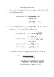
USER MANUAL SWAN Cycle III version 40.72A
USER MANUAL SWAN Cycle III version 40.72A
USER MANUAL SWAN Cycle III version 40.72A

Create successful ePaper yourself
Turn your PDF publications into a flip-book with our unique Google optimized e-Paper software.
8 Chapter 2<br />
below). Directions and spherical coordinates are in degrees ( 0 ) and not in radians.<br />
For the output of wave energy the user can choose between variance (m 2 ) or energy (spatial)<br />
density (Joule/m 2 , i.e. energy per unit sea surface) and the equivalents in case of<br />
energy transport (m 3 /s or W/m, i.e. energy transport per unit length) and spectral energy<br />
density (m 2 /Hz/Degr or Js/m 2 /rad, i.e. energy per unit frequency and direction per unit<br />
sea surface area). The wave−induced stress components (obtained as spatial derivatives of<br />
wave-induced radiation stress) are always expressed in N/m 2 even if the wave energy is in<br />
terms of variance. Note that the energy density is also in Joule/m 2 in the case of spherical<br />
coordinates.<br />
<strong>SWAN</strong> operates either in a Cartesian coordinate system or in a spherical coordinate system,<br />
i.e. in a flat plane or on a spherical Earth. In the Cartesian system, all geographic<br />
locations and orientations in <strong>SWAN</strong>, e.g. for the bottom grid or for output points, are<br />
defined in one common Cartesian coordinate system with origin (0,0) by definition. This<br />
geographic origin may be chosen totally arbitrarily by the user. In the spherical system,<br />
all geographic locations and orientations in <strong>SWAN</strong>, e.g. for the bottom grid or for output<br />
points, are defined in geographic longitude and latitude. Both coordinate systems are designated<br />
in this manual as the problem coordinate system.<br />
In the input and output of <strong>SWAN</strong> the direction of wind and waves are defined according<br />
to either<br />
• the Cartesian convention, i.e. the direction to where the vector points, measured<br />
counterclockwise from the positive x−axis of this system (in degrees) or<br />
• a nautical convention (there are more such conventions), i.e. the direction where the<br />
wind or the waves come from, measured clockwise from geographic North.<br />
All other directions, such as orientation of grids, are according to the Cartesian convention!<br />
For regular grids, i.e. uniform and rectangular, Figure 4.1 (in Section 4.5) shows how the<br />
locations of the various grids are determined with respect to the problem coordinates. All<br />
grid points of curvi-linear and unstructured grids are relative to the problem coordinate<br />
system.<br />
2.6 Choice of grids, time windows and boundary /<br />
initial / first guess conditions<br />
2.6.1 Introduction<br />
Several types of grids and time window(s) need to be defined: (a) spectral grid, (b) spatial<br />
(geographic) grids and time window(s) in case of nonstationary computations.<br />
The spectral grid that need to be defined by the user is a computational spectral grid on