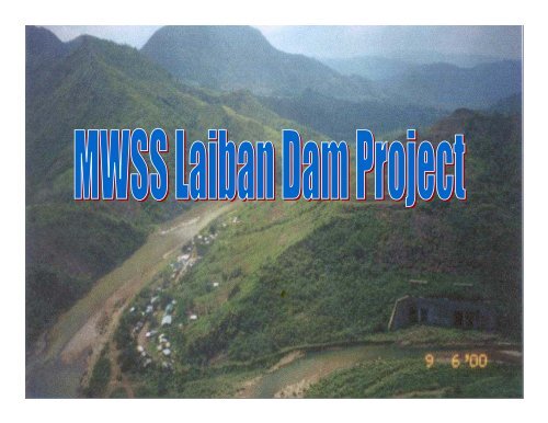
View the MWSS Laiban Dam Project Information Sheet
View the MWSS Laiban Dam Project Information Sheet
View the MWSS Laiban Dam Project Information Sheet

Create successful ePaper yourself
Turn your PDF publications into a flip-book with our unique Google optimized e-Paper software.
PROJECT PROFILE<br />
• The <strong>Project</strong> is a multi-purpose water supply<br />
and power project;<br />
• The second major source of water for Metro<br />
Manila, after Angat <strong>Dam</strong>.<br />
• Provides 1,900 MLD of water & 25 MW power.<br />
• A 113-meter high dam on <strong>the</strong> Kaliwa River in<br />
Tanay, Rizal.<br />
• Situated east of Metro Manila on a<br />
mountainous watershed of about 28,000<br />
hectares in <strong>the</strong> Sierra Madre Mountains.
Angat <strong>Dam</strong><br />
Kanan <strong>Dam</strong><br />
La Mesa <strong>Dam</strong><br />
To Distribution System<br />
Cogeo Reservoir<br />
<strong>Laiban</strong> <strong>Dam</strong><br />
Pantay WTP<br />
Laguna de Bay<br />
PROJECT LAY-OUT
PROJECT COMPONENTS<br />
Pantay<br />
2400MLD<br />
WTP<br />
Resettlement Site<br />
Taytay Res =<br />
120 ML<br />
Antipolo<br />
Res= 20ML<br />
25 MW<br />
HEP<br />
<strong>Dam</strong><br />
PS<br />
Tunnel<br />
Conveyance<br />
line<br />
The <strong>Project</strong>:<br />
• 1,900 MLD additional supply<br />
• <strong>Dam</strong> height: 113M<br />
• Affected Families: 4,413<br />
• <strong>Project</strong> cost – P 48B
MAJOR WORKS UNDERTAKEN<br />
• FS and detailed engineering for <strong>the</strong> <strong>Project</strong> were already<br />
completed in 1980’s including <strong>the</strong> construction of <strong>the</strong><br />
diversion tunnels<br />
• Some of <strong>the</strong> affected families were already compensated of<br />
<strong>the</strong>ir above-ground improvements and several titled<br />
properties have also been acquired<br />
• The <strong>Project</strong> including <strong>the</strong> supposed relocation was<br />
deferred in 1989 in lieu of an equally important projects,<br />
<strong>the</strong> Angat Water Supply Optimization <strong>Project</strong> (AWSOP)<br />
and <strong>the</strong> Umiray-Angat Transbasin <strong>Project</strong> (UATP)<br />
• Several reviews & updating were conducted to prepare <strong>the</strong><br />
<strong>Project</strong> for tendering and eventually for funding ei<strong>the</strong>r<br />
thru Build-Operate-Transfer (BOT) or o<strong>the</strong>r financing<br />
scheme.
ENVIRONMENTAL CONDITION<br />
• Kaliwa watershed area<br />
is 28,000 has., of<br />
which 70% is in Tanay
ENVIRONMENTAL CONDITION<br />
THE VALLEY OF LENATIN RIVER,<br />
WHICH FORMS THE WESTERN SIDE<br />
OF THE CATCHMENT, IS<br />
CHARACTERIZED BY SPARSE<br />
VEGETATION CONSISTING OF<br />
BUSHES AND SCATTERED TREES.<br />
LIMUTAN WATERSHED HAS<br />
MODERATE TO INTENSIVE<br />
FOREST COVER AND VIRTUALLY<br />
INACCESSIBLE
ENVIRONMENTAL CONDITION<br />
• Reduction of forest cover due to small scale<br />
logging, grazing and kaingin have continued in<br />
various parts of <strong>the</strong> catchment basin<br />
• Population has increased and new houses and<br />
government structures are existing and being<br />
built within <strong>the</strong> watershed<br />
Residential Structures<br />
Barangay Centers<br />
2-storey School Bldg.
Mitigating Measures on<br />
Environmental Impacts:<br />
• Organize a Multi-Partite Monitoring Team<br />
(MMT) that will monitor progress of work<br />
and compliance with ECC and<br />
Environmental Management Plan<br />
• Allocate an Environmental Guarantee Fund<br />
• Implementation of a Watershed<br />
Management Plan with active participation<br />
of <strong>the</strong> local communities
BGY. STA. INES<br />
AF=474<br />
PROJECT IMPACT<br />
FLOODING OF 7 BGYS. IN<br />
TANAY, 1 IN GENERAL<br />
NAKAR, PANTAY WTP &<br />
SAN YSIRO RELOC SITE<br />
(4,413 affected families)<br />
BGY. MAMUYAO<br />
AF=323<br />
BGY. LIMUTAN<br />
AF=390<br />
BGY. TINUKAN<br />
AF=290<br />
BGY. CAYABU<br />
AF=175<br />
BGY. STO. NINO<br />
AF=318<br />
BGY. LAIBAN<br />
AF=720<br />
BGY. SAN ANDRES<br />
AF=423<br />
BGY. DARAITAN<br />
AF = 591<br />
Source: DENR
PROJECT IMPACT<br />
• Erosion of sediments<br />
• Irreversible loss of agricultural resources<br />
and scenic spots (Sta. Ines Falls, Sangab<br />
Cave)<br />
• Destruction or interference with habitats<br />
• Impairment of cultural areas/monuments<br />
and ancestral domains of indigenous<br />
people (IPs)<br />
• Relocation of settlers
Indicative <strong>Project</strong> Schedule<br />
ACTIVITY<br />
2007 2008 2009<br />
1 2 3 4 1 2 3 4 1 2 3 4<br />
2010<br />
1 2 3 4<br />
2011<br />
1 2 3 4<br />
2012<br />
1 2 3 4<br />
2013<br />
1 2 3 4<br />
2014<br />
1 2 3 4<br />
2015<br />
1 2 3 4<br />
Pre-Construction Activities<br />
(LARP, ECC, LGU endorsement, etc)<br />
Fund Sourcing (BOT)<br />
Contracting Phase<br />
Land Acquisition & Resettlement<br />
(including livelihood assistance)<br />
Construction<br />
Commissioning<br />
NEDA-ICC Approved <strong>Project</strong> Cost = PhP 47.93B
Current Status (as of 15 June 2008)<br />
• Since this <strong>Project</strong> was cancelled under <strong>the</strong> China Loan, <strong>MWSS</strong> is<br />
now pursuing o<strong>the</strong>r mode of procurement ei<strong>the</strong>r solicited or<br />
unsolicited proposals. In fact, Memoranda of Understanding<br />
(MOUs) were already signed by <strong>MWSS</strong> with several interested<br />
proponents for <strong>the</strong> conduct of due diligence on <strong>the</strong> <strong>Project</strong>. At<br />
present, an American firm, CalEnergy International, is presently<br />
doing due diligence and soon to submit its proposal.<br />
• Meantime, <strong>the</strong> following pre-construction activities is in progress:<br />
- Processing of <strong>the</strong> new ECC of <strong>the</strong> <strong>Project</strong>;<br />
- Processing of <strong>the</strong> Free and Prior Inform Consent (FPIC)<br />
clearance from <strong>the</strong> National Commission on Indigenous People<br />
(NCIP); and<br />
- Continuing dialogue/meeting with <strong>the</strong> LGU particularly <strong>the</strong><br />
municipality of Tanay, Rizal and <strong>the</strong> affected barangays relative<br />
to <strong>the</strong> LGU’s endorsement of <strong>the</strong> <strong>Project</strong>.
NEDA-ICC Approved <strong>Project</strong> Cost Estimate<br />
<strong>Project</strong> Components<br />
Headworks (dams, tunnels etc.)<br />
Treatment Plant<br />
Distribution System<br />
Environmental & Watershed<br />
Management<br />
Resettlement<br />
Right-of-way<br />
Indirect Costs (Eng’g., Taxes,<br />
Contingencies, etc)<br />
IDC and front-end fee<br />
TOTAL<br />
Cost (PhP M)<br />
13,060.00<br />
3,254.00<br />
9,951.00<br />
90.00<br />
7,417.00<br />
2,651.00<br />
6,306.00<br />
5,560.00<br />
47,929.00
Parcel 1<br />
Proposed Resettlement<br />
Site in San Ysiro, Antipolo<br />
City as proclaimed under<br />
Proclamation No. 2480<br />
Issued on Jan 26, 1986<br />
Area<br />
(hectares)<br />
Parcel 4<br />
Parcel 2<br />
<strong>MWSS</strong><br />
Property<br />
1,507<br />
<strong>MWSS</strong> Titled Property<br />
Lot 1 = 232 hectares<br />
Lot 2 = 1,275 hectares<br />
Total = 1,507 hectares<br />
Parcel 1<br />
Parcel 2<br />
Parcel 3<br />
Parcel 4<br />
887<br />
360<br />
379<br />
1,291<br />
Parcel 3<br />
Total<br />
4,424
PROJECT LOCATION<br />
PROJECT LOCATION<br />
<strong>Laiban</strong> <strong>Dam</strong> Site<br />
(about 70 kms road<br />
distance from <strong>MWSS</strong>)
<strong>Project</strong> Affected Families<br />
8 mountain barangays<br />
in Tanay including Brgy<br />
Daraitan<br />
Brgy. Limutan, Gen.<br />
Nakar, Quezon<br />
San Ysiro, Antipolo City<br />
(relocation site)<br />
Pantay Water Treatment<br />
Plant (Antipolo City)<br />
1984 Census<br />
2,372<br />
13<br />
182<br />
-<br />
2006 Census<br />
3,314<br />
390<br />
643<br />
66<br />
Total<br />
2,567<br />
4,413
Parcel 1<br />
Proposed Resettlement<br />
Site in San Ysiro, Antipolo<br />
City as proclaimed under<br />
Proclamation No. 2480<br />
Issued on Jan 26, 1986<br />
Area<br />
(hectares)<br />
Parcel 4<br />
Parcel 2<br />
<strong>MWSS</strong><br />
Property<br />
1,507<br />
<strong>MWSS</strong> Titled Property<br />
Lot 1 = 232 hectares<br />
Lot 2 = 1,275 hectares<br />
Total = 1,507 hectares<br />
Parcel 1<br />
Parcel 2<br />
Parcel 3<br />
Parcel 4<br />
887<br />
360<br />
379<br />
1,291<br />
Parcel 3<br />
Total<br />
4,424
Total Expenditures To Date:<br />
Description<br />
• Before <strong>MWSS</strong> Privatization:<br />
(FS, Detailed Engg., Diversion tunnels,<br />
partial land acquisition, and o<strong>the</strong>r preconstruction<br />
activities)<br />
• After <strong>MWSS</strong> Privatization:<br />
Amt (PhP M)<br />
690.00<br />
65.00<br />
a) (Review/Updating of documents including preliminary<br />
resettlement planning), year 2001 -------------- 36.00M<br />
b) Technical review & assess tender docs for construction,<br />
year 2006-2007 -------------------------------------- 24.00M<br />
c) Fur<strong>the</strong>r geological investigation at damsite<br />
(on-going) -----------------------------------------------5.00M<br />
TOTAL<br />
755.00<br />
NEDA-ICC approved <strong>Project</strong> Cost (2007) = PhP 47.93B
Million Liters Per Day<br />
10000<br />
9000<br />
8000<br />
7000<br />
6000<br />
5000<br />
4000<br />
3000<br />
Water Supply-Demand <strong>Project</strong>ion<br />
Present Water Demand<br />
(2007) = 5,200 MLD<br />
Sumag(188mld)<br />
+ Wawa (50mld)<br />
2005<br />
2006<br />
2007<br />
2008<br />
<strong>Laiban</strong> Phase 1 (1220 mld)<br />
= 538 mld<br />
+ 300mld Treated Bulk Water<br />
2009<br />
2010<br />
2011<br />
2012<br />
2013<br />
2014<br />
2015<br />
2016<br />
<strong>Laiban</strong> Phase 2 (610 mld)<br />
Present Water Supply from Angat = 4,000 MLD<br />
2017<br />
2018<br />
2019<br />
2020<br />
Kanan Phase 1 (1090 mld)<br />
Kanan Phase 2 (1090 mld)<br />
Year<br />
Supply Demand Present Supply (4000 mld)<br />
Kanan Phase 3 (1090 mld)<br />
2021<br />
2022<br />
2023<br />
2024<br />
2025<br />
2027<br />
2029<br />
2031<br />
2034<br />
2036<br />
2038<br />
2040
KALIWA WATERSHED (28,000 has.)<br />
DARAITAN<br />
MADILAY-DILAY<br />
AREA OF WATERSHED = 28,000 HAS<br />
DAM<br />
KALIWA RIVER<br />
Diversion Tunnel<br />
FLOW<br />
MAMUYAO<br />
LIMUTAN RIVER<br />
LENATIN RIVER<br />
LAIBAN<br />
STO.NIÑO<br />
KUYAMBAY<br />
SAN ANDRES<br />
STA. INES<br />
TINUKAN<br />
CAYABU<br />
INTAKE
PROJECT LOCATION<br />
Proposed Relocation Site<br />
San Ysiro, Antipolo City<br />
Special Relocation Site declared<br />
under Proc. #2480 in 1986<br />
Marcos Highway<br />
Proposed <strong>Laiban</strong> <strong>Dam</strong> located about<br />
70 kms road distance from <strong>MWSS</strong>
<strong>Project</strong> Lay-out<br />
San Ysiro Reloc Site<br />
4,400 hectares<br />
Completed<br />
Diversion tunnel