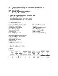
Supporting Documents (Data and Analysis) - Satellite Beach
Supporting Documents (Data and Analysis) - Satellite Beach
Supporting Documents (Data and Analysis) - Satellite Beach

You also want an ePaper? Increase the reach of your titles
YUMPU automatically turns print PDFs into web optimized ePapers that Google loves.
Nature Park provides a 52-acre open space bordered by 1.0 mile of shoreline for public use on the<br />
Banana River. The City continues to investigate opportunities to develop increased access to the<br />
Banana River. The City has no marina facilities <strong>and</strong> has a policy to not provide such facilities in the<br />
future.<br />
The City will continue to provide public access to the oceanic shoreline, <strong>and</strong> the potential exists for<br />
providing additional access to the Banana River as Samsons Isl<strong>and</strong> Nature Park is developed. Given<br />
the current l<strong>and</strong> use pattern of the City, no criteria for shoreline uses other than public access would<br />
be appropriate.<br />
Economic Base<br />
The economic base of the coastal area is comprised of residential l<strong>and</strong> use, services, <strong>and</strong> facilities to<br />
meet the needs of the resident <strong>and</strong> seasonal population. As noted in the Future L<strong>and</strong> Use Element,<br />
less than 1.0% of the City's l<strong>and</strong> area (5 acres in a single tract) will be developed with industrial uses<br />
at the time of build-out. Service businesses, as well as retail establishments within the City,<br />
primarily serve the needs of City residents. They also serve non-City clientele due to the regional<br />
trade area of some City businesses. The ratio of commercial l<strong>and</strong> use to residential l<strong>and</strong> use in<br />
<strong>Satellite</strong> <strong>Beach</strong> is approximately 1:10, which indicates the City does not have a substantial<br />
commercial/service trade area beyond the City’s boundaries.<br />
Historic Resources<br />
The City of <strong>Satellite</strong> <strong>Beach</strong> has no areas or structures known to be appropriate for historic<br />
preservation. Neither the Florida Master Site File maintained by the Division of Historic Resources<br />
nor the National Register of Historic Places contains references to sites or structures within the City.<br />
Holy Apostles Episcopal Church, built in Fort Pierce by local artisans with local materials in 1905<br />
<strong>and</strong> moved by barge to <strong>Satellite</strong> <strong>Beach</strong> in the 1950s when no longer needed at its original location, is<br />
the only known potential c<strong>and</strong>idate for listing as a historic structure in the City. Aerial photography<br />
taken in 1954 shows no structures within current City boundaries. The only infrastructure evident is<br />
a two-lane SR A1A <strong>and</strong> east-west drainage channels.<br />
Coastal High-Hazard Area (CHHA)<br />
The Coastal High Hazard Area (CHHA) is the area defined by the Sea, Lake, <strong>and</strong> Overl<strong>and</strong> Surge<br />
from Hurricanes (SLOSH) Model to be inundated from a category one hurricane as established by<br />
the most recent hurricane evacuation study prepared by the East Central Florida Regional Planning<br />
Council (ECFRPC). In the City of <strong>Satellite</strong> <strong>Beach</strong>, the CHHA encompasses a thin strip of l<strong>and</strong> along<br />
the Atlantic Coastline <strong>and</strong> the westernmost part of the City, which is for the most part, located west<br />
of South Patrick Drive. As shown on the CHHA map.<br />
Coastal Construction Control Line (CCCL)<br />
Permit approval for oceanfront development must be obtained from both the <strong>Satellite</strong> <strong>Beach</strong> City<br />
Council <strong>and</strong> the Florida Department of Environmental Protection (FDEP). The FDEP administers<br />
the Coastal Construction Control Line (CCCL) <strong>and</strong> thirty-year erosion setbacks to minimize impacts<br />
Coastal Management/Conservation Element<br />
<strong>Data</strong> <strong>and</strong> <strong>Analysis</strong> 5-6