catalogue text.indd - Sanders of Oxford
catalogue text.indd - Sanders of Oxford
catalogue text.indd - Sanders of Oxford

Create successful ePaper yourself
Turn your PDF publications into a flip-book with our unique Google optimized e-Paper software.
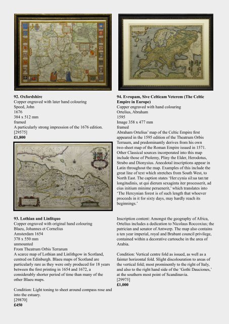
92. <strong>Oxford</strong>shire<br />
Copper engraved with later hand colouring<br />
Speed, John<br />
1676<br />
384 x 512 mm<br />
framed<br />
A particularly strong impression <strong>of</strong> the 1676 edition.<br />
[29575]<br />
£1,800<br />
94. Evropam, Sive Celticam Veterem (The Celtic<br />
Empire in Europe)<br />
Copper engraved with hand colouring<br />
Ortelius, Abraham<br />
1595<br />
Image 358 x 477 mm<br />
framed<br />
Abraham Ortelius’ map <strong>of</strong> the Celtic Empire first<br />
appeared in the 1595 edition <strong>of</strong> the Theatrum Orbis<br />
Terraum, and predominantly derives from his own<br />
two-sheet map <strong>of</strong> the Roman Empire issued in 1571.<br />
Other Classical sources incorporated into this map<br />
include those <strong>of</strong> Ptolemy, Pliny the Elder, Herodotus,<br />
Strabo and Dionysius. Anecdotal inscriptions appear in<br />
Latin throughout the map. Examples <strong>of</strong> this include the<br />
great line <strong>of</strong> <strong>text</strong> which stretches from South West, to<br />
North East. The caption states ‘Her:cynia sil:ua tan:tæ<br />
longitudinis, ut qui dierum sexaginta iter processerit, ad<br />
eius initium minime peruenerit,’ which translates into<br />
‘The Hercynian forest is <strong>of</strong> such length that whoever<br />
proceeds in it for sixty days, may hardly reach its<br />
beginnings.’<br />
93. Lothian and Linlitquo<br />
Copper engraved with original hand colouring<br />
Blaeu, Johannes et Cornelius<br />
Amsterdam 1654<br />
378 x 550 mm<br />
unmounted<br />
From Theatrum Orbis Terrarum<br />
A scarce map <strong>of</strong> Lothian and Linlithgow in Scotland,<br />
centred on Edinburgh. Blaeu maps <strong>of</strong> Scotland are<br />
particularly rare as they were only produced for 18 years<br />
between the first printing in 1654 and 1672, a<br />
considerably shorter period <strong>of</strong> time than many <strong>of</strong> the<br />
other Blaeu maps.<br />
Condition: Light toning to sheet around compass rose and<br />
into the estuary.<br />
[29870]<br />
£450<br />
Inscription content: Amongst the geography <strong>of</strong> Africa,<br />
Ortelius includes a dedication to Nicolaus Roccoxius; the<br />
patrician and senator <strong>of</strong> Antwerp. The map also contains<br />
a ten year imperial, royal and Brabant council privilege,<br />
contained within a decorative cartouche in the area <strong>of</strong><br />
Arabia.<br />
Condition: Vertical centre fold as issued, as well as a<br />
fainter horizontal fold. Slight discolouration to areas <strong>of</strong><br />
the vertical fold; most prominently to the right <strong>of</strong> Italy,<br />
and also to the right hand side <strong>of</strong> the ‘Gothi Dauciones,’<br />
at the southern most point <strong>of</strong> Scandinavia.<br />
[29975]<br />
£1,000