
You also want an ePaper? Increase the reach of your titles
YUMPU automatically turns print PDFs into web optimized ePapers that Google loves.
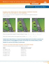
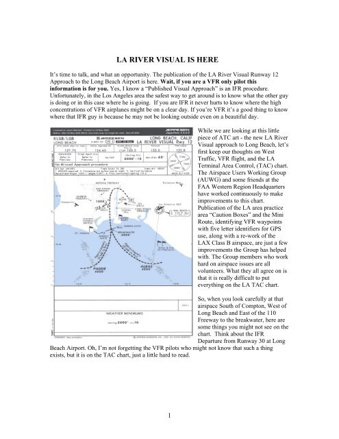
<strong>LA</strong> RIVER VISUAL IS HERE<br />
It’s time to talk, and what an opportunity. The publication of the <strong>LA</strong> <strong>River</strong> <strong>Visual</strong> Runway 12<br />
<strong>Approach</strong> to the Long Beach Airport is here. Wait, if you are a VFR only pilot this<br />
information is for you. Yes, I know a “Published <strong>Visual</strong> <strong>Approach</strong>” is an IFR procedure.<br />
Unfortunately, in the Los Angeles area the safest way to get around is to know what the other guy<br />
is doing or in this case where he is going. If you are IFR it never hurts to know where the high<br />
concentrations of VFR airplanes might be on a clear day. If you’re VFR it’s a good thing to know<br />
where that IFR guy is because he may not be looking outside even on a beautiful day.<br />
While we are looking at this little<br />
piece of ATC art - the new <strong>LA</strong> <strong>River</strong><br />
<strong>Visual</strong> approach to Long Beach, let’s<br />
first keep our thoughts on West<br />
Traffic, VFR flight, and the <strong>LA</strong><br />
Terminal Area Control, (TAC) chart.<br />
The Airspace Users Working Group<br />
(AUWG) and some friends at the<br />
FAA Western Region Headquarters<br />
have worked continuously to make<br />
improvements to this chart.<br />
Publication of the <strong>LA</strong> area practice<br />
area “Caution Boxes” and the Mini<br />
Route, identifying VFR waypoints<br />
with five letter identifiers for GPS<br />
use, along with a re-work of the<br />
<strong>LA</strong>X Class B airspace, are just a few<br />
improvements the Group has helped<br />
with. The Group members who work<br />
hard on airspace issues are all<br />
volunteers. What they all agree on is<br />
that it is really difficult to put<br />
everything on the <strong>LA</strong> TAC chart.<br />
So, when you look carefully at that<br />
airspace South of Compton, West of<br />
Long Beach and East of the 110<br />
Freeway to the breakwater, here are<br />
some things you might not see on the<br />
chart. Think about the IFR<br />
Departure from Runway 30 at Long<br />
Beach Airport. Oh, I’m not forgetting the VFR pilots who might not know that such a thing<br />
exists, but it is on the TAC chart, just a little hard to read.<br />
1
Here is how it goes. Jet and high performance airplanes departing IFR from Runway 30 are<br />
instructed to “fly runway heading to 1,500 feet, then turn left to a heading of 180 and climb to<br />
3,000 feet.” (There have been several tests run lately to come up with a better heading, but this<br />
is the official departure). Somewhere between 1,500 and 3,000 feet there is a hand off between<br />
LGB Tower ATC and SOCAL TRACON. Unfortunately, we are still working on a better<br />
solution for what happens next. For now the continued climb to higher must wait until SOCAL<br />
establishes the radar hand-off and communications with each IFR departure. This is to ensure no<br />
one is in the way prior to issuing instructions for continued climb.<br />
The question is, “are you in the way?” Oh, I know everyone has rights to the airspace, but we<br />
are trying to make it work without establishing more restricted airspace. I also know it’s a see<br />
and be seen world up there, but have you ever tried turning an Airbus abruptly, or climbing it<br />
rapidly to miss another airplane. Well it’s not fun for either aircraft, and especially for the<br />
passengers in the “back of the bus”. Remember now, the Airbus crew is responding to a TCAS<br />
alert and must respond appropriately. You see them because they are BIG, but can they see you?<br />
How hard is it to stay out of the way? Well remember that 3,000 foot assignment the jet off LGB<br />
is climbing to maintain? You need to either be below that by 500 feet to avoid being his TCAS<br />
alert, 1,000 feet not to be his wake turbulence victim, or well above that jet if you are in the area<br />
not talking to SOCAL. Why so much above you ask? Well, because the jet may still be climbing<br />
if SOCAL can work it out. If not the jet is going to be forced to fly low right through a<br />
concentration of little airplanes transitioning or training off shore. Are we asking you to avoid the<br />
departure route - Yes, Please.<br />
Next, remember there is a 2,000 foot crossing altitude near the Vincent Thomas Bridge called the<br />
Bason Intersection, or sometimes referred to as the “Final <strong>Approach</strong> Fix” for the Torrance ILS.<br />
This fix is only on the approach chart for Torrance Runway 29R; don’t look for it on an IFR chart<br />
or the TAC chart for <strong>LA</strong>. So, do you think one of those guys approaching Bason could have a<br />
hood on and neither pilot is looking outside because that instrument instructor is giving his best<br />
ILS dual?<br />
Don’t worry about the traffic on the two airways, V23 and V64 that run through the area. Don’t<br />
worry unless you are at 4,000 or 5,000 feet. The IFR traffic, unless they are climbing, (maybe<br />
worry then) should be at those altitudes, and you should be at odd thousands plus 500 feet right?<br />
Wait, are you climbing or descending?<br />
Do I know, what’s the best altitude to transition? I like 1,500 feet, it keeps me clear and I still<br />
have forced landing areas if I think about it. Of course you can climb up above Torrance Airport,<br />
stay well west of the 110 Freeway, and well west of the Long Beach Departures. Or, stay in<br />
contact with Long Beach Tower and use there airspace east of the <strong>LA</strong> <strong>River</strong>. Finally, my true<br />
favorite, maybe talk to SOCAL TRACON and let them help you through the area, especially if<br />
you are going to be near the jet IFR departure route from Long Beach Runway 30.<br />
2
OK, now the new visual approach SOCAL cooked up with a little help from their friends. The<br />
procedure is not that new, it’s what some pilots and controllers have been doing for a long time<br />
when Long Beach Airport is East Traffic. This is especially true when the airport is turned around<br />
because of those famous Santa Ana Winds, and not storms that keep it using the IFR approaches<br />
with a circle to land. On a clear day pilots normally get vectored for a <strong>Visual</strong> right base to<br />
Runway 12. Now the procedure is official and in print. Arrivals to Runway 12 come right up the<br />
<strong>LA</strong> <strong>River</strong> with most of low flying done in the Long Beach Class D surface area. However, the<br />
entry points, (Pador and Albas Intersections) were picked to be far enough off shore and well<br />
known enough that pilots are familiar with them. It does mean airplanes in the practice area need<br />
to be aware when East Traffic is in operation. Then you will know where the big airplanes need<br />
to fly to arrive safely at Long Beach, what altitude they should be at, and how you can help them<br />
accomplish that all important goal of arriving safely by avoiding their flight path.<br />
If you have questions about this approach, or any airspace question, remember your local Flight<br />
Standards District Office, Aviation Safety Program Manager is just a phone call away. If<br />
necessary they can refer you to the Southern California Airspace Users Group and one of us will<br />
be happy to help.<br />
Patrick T. Carey<br />
Co-Chairman, AUWG<br />
DPE , FAA <strong>LA</strong>X FSDO<br />
3