

CHAPTER 10 – HAZARDS AND HAZARDOUS MATERIALS - sacog
CHAPTER 10 – HAZARDS AND HAZARDOUS MATERIALS - sacog
CHAPTER 10 – HAZARDS AND HAZARDOUS MATERIALS - sacog

You also want an ePaper? Increase the reach of your titles
YUMPU automatically turns print PDFs into web optimized ePapers that Google loves.
<strong>CHAPTER</strong> <strong>10</strong> <strong>–</strong> <strong>HAZARDS</strong> <strong>AND</strong> <strong>HAZARDOUS</strong> <strong>MATERIALS</strong><br />
INTRODUCTION<br />
This chapter describes the existing conditions (environmental and regulatory) and assesses the<br />
potential of the Metropolitan Transportation Plan/Sustainable Communities Strategy for 2035<br />
(proposed MTP/SCS) to affect the hazards and hazardous materials environment within the<br />
MTP/SCS plan area. In addition, this chapter discusses emergency services and emergency<br />
plans. This chapter evaluates potential impacts on hazards and hazardous materials that may<br />
result from implementation of the proposed MTP/SCS. Where necessary and feasible, mitigation<br />
measures are identified to reduce these impacts.<br />
One comment regarding public exposures from hazards and hazardous materials, submitted by<br />
Rick Bettis, was received during circulation of the Notice of Preparation (NOP), requesting that<br />
the potential public exposure to hazardous materials resulting from the location of transportation<br />
facilities and related land use is addressed. Refer to Appendix PD-1 for more details.<br />
SETTING<br />
Environmental Setting<br />
Hazardous Materials<br />
Hazardous materials exist in many forms such as liquids, solids, or contained gases, and can be<br />
man-made or naturally occurring. These materials can be found in many places such as in<br />
groundwater, used materials, rocks (asbestos), and as a result of an accident; they can also be an<br />
input into industrial processes, and a normal part of business operations for some industries.<br />
The land uses associated with hazardous materials, and the transportation of hazardous materials<br />
and wastes, are significant issues that will be discussed in this chapter. Worker health and<br />
safety, administered by the United States Occupational Safety and Health Administration<br />
(OSHA), and public safety are key issues when dealing with hazardous materials that may affect<br />
human health and the environment. Proper disposal of hazardous material is vital if it is<br />
disturbed during the construction of projects in the proposed MTP/SCS.<br />
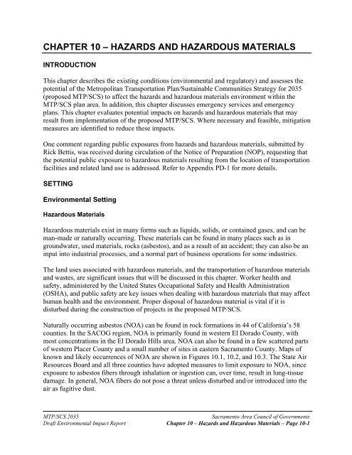
Naturally occurring asbestos (NOA) can be found in rock formations in 44 of California’s 58<br />
counties. In the SACOG region, NOA is primarily found in western El Dorado County, with<br />
most concentrations in the El Dorado Hills area. NOA can also be found in a few scattered parts<br />
of western Placer County and a small number of sites in eastern Sacramento County. Maps of<br />
known and likely occurrences of NOA are shown in Figures <strong>10</strong>.1, <strong>10</strong>.2, and <strong>10</strong>.3. The State Air<br />
Resources Board and all three counties have adopted measures to limit exposure to NOA, since<br />
exposure to asbestos fibers through inhalation or ingestion can, over time, result in lung-tissue<br />
damage. In general, NOA fibers do not pose a threat unless disturbed and/or introduced into the<br />
air as fugitive dust.<br />
MTP/SCS 2035<br />
Sacramento Area Council of Governments<br />
Draft Environmental Impact Report Chapter <strong>10</strong> <strong>–</strong> Hazards and Hazardous Materials <strong>–</strong> Page <strong>10</strong>-1
ST49<br />
ST193<br />
ST49<br />
El Dorado<br />
County<br />
£¤ 50 ST49<br />
Miles<br />
0 2.5<br />
5 <strong>10</strong><br />
Fault Lines<br />
Found Area of NOA<br />
Quarter mile Buffer of Found Area of NOA<br />
Areas More Likely to Contain Asbestos<br />
Quarter Mile Buffer Likely to Contain Asbestos<br />
Cities<br />
Water features<br />
Counties<br />
Figure <strong>10</strong>.1 Naturally Occuring Asbestos in El Dorado County
F n<br />
igure <strong>10</strong>.2- Naturally Occuring Asbestos in Placer County<br />
Source: El Dorado County Survey/GIS Divisio<br />
Areas Most Likely to Contain NOA: These area includes ultramafic<br />
rocks and serpentinite (serpentine rock), and associated soils, which<br />
are most likely to contain NOA.<br />
Areas Moderately Likely to Contain NOA:These areas include those<br />
metamorphic and igneous rocks that are moderately likely to contain NOA.<br />
Areas Least Likely to Contain NOA: These areas include those<br />
metamorphic, igneous, and sedimentary rocks that are least likely<br />
to contain NOA.
Areas Most Likely to Contain NOA: These area includes ultramafic<br />
rocks and serpentinite (serpentine rock), and associated soils, which<br />
are most likely to contain NOA.<br />
Areas Moderately Likely to Contain NOA:These areas include those<br />
metamorphic and igneous rocks that are moderately likely to contain NOA.<br />
Areas Least Likely to Contain NOA: These areas include those<br />
metamorphic, igneous, and sedimentary rocks that are least likely<br />
to contain NOA.<br />
Figure <strong>10</strong>.3- Naturally Occuring Asbestos in Sacramento County<br />
Source: California Geological Survey http://www.consrv/ca/gov/cgs
Hazardous Waste Generation and Management<br />
There are four general categories of waste management: source reduction, recycling, treatment,<br />
and residuals disposal. All of these activities can occur on-site at the location where they are<br />
generated. Recycling, treatment, and disposal can also occur off-site but require additional<br />
intermediate support to store and transport waste.<br />
The generation and handling of hazardous waste in the region is monitored by the U.S.<br />
Environmental Protection Agency (EPA); Central Valley Regional Water Quality Control<br />
Board; Sacramento Metropolitan Air Quality Management District; and the Environmental<br />
Health and Hazardous Materials Control divisions of the six counties in the plan area.<br />
Businesses that generate hazardous waste are either Large-Quantity Generators (e.g., heavy<br />
industrial or commercial facilities) or Small-Quantity Generators (e.g., dry cleaners, automotive<br />
repair shops, etc.); these businesses require an EPA identification number used to monitor and<br />
track hazardous waste activities.<br />
Certain land uses may also serve as an indication that there is a potential for generating<br />
hazardous materials or waste, or existing hazardous materials or waste may be present.<br />
Hazardous wastes can be generated during a transportation project’s construction activities.<br />
Common examples include oil, transmission fluids, fuels, solvents, and adhesives. Unless<br />
standard precautions are taken during construction, these wastes can be released into the<br />
environment.<br />
Transport of Hazardous Materials<br />
The potential harm that hazardous waste can cause to people and the environment has warranted<br />
concern by national, state, and local governments on the safe transport of hazardous materials.<br />
Since hazardous materials are transported primarily on facilities shared by the public such as<br />
highways, rail lines and local roads, there is greater public exposure to these materials.<br />
The proposed MTP/SCS addresses the movement of goods and people throughout the region.<br />
Within the context of the proposed MTP/SCS, the transportation of hazardous materials can take<br />
place by motor vehicle, pipeline, rail, ship, and air. As with the movement of goods and people<br />
in general, the movement of hazardous materials can be defined by trips and modes. Any given<br />
“trip” from origin to destination can involve one or more “modes.” In other words, a shipment<br />
may begin on a truck and be transferred to a train and then again to another truck to reach its<br />
final destination. Table <strong>10</strong>.1 describes a rough estimate of the volume of hazardous materials<br />
shipped in the region and the mode of transportation used.<br />
The U.S. Department of Transportation (USDOT) regulates the transportation of hazardous<br />
materials by truck and rail, and the California Health Services Department regulates the haulers<br />
of hazardous waste.<br />
A valid registration issued by the California Department of Toxic Substances Control (DTSC) is<br />
required, unless specifically exempted, to transport hazardous wastes. The California<br />
Department of Motor Vehicles (DMV) requires all hazardous materials transporters to possess a<br />
MTP/SCS 2035<br />
Sacramento Area Council of Governments<br />
Draft Environmental Impact Report Chapter <strong>10</strong> <strong>–</strong> Hazards and Hazardous Materials <strong>–</strong> Page <strong>10</strong>-5
commercial driver’s license with a hazardous materials endorsement under the following<br />
circumstances:<br />
<br />
<br />
Hazardous materials shipments (unless specifically exempted) for which the display<br />
of placards is required per California Vehicle Code Section 27903.<br />
Hazardous materials shipments in excess of 500 lbs., transported for a fee, which<br />
would require placarding if shipped in greater amounts in the same manner.<br />
Table <strong>10</strong>.1<br />
Shipment Characteristics by Mode of Transportation for CBSA of Origin:<br />
2007 Sacramento—Arden Arcade—Yuba City, CA‐NV (CA part)<br />
Shipment Characteristics by Mode of Transportation for the United States: 2007<br />
Hazardous<br />
Materials<br />
Tons All Freight Tons (percent Estimate by Mode Percent Share of<br />
Mode of transportation 2007 (thousands) of Total) (thousands) All Freight<br />
All modes 63,705 <strong>10</strong>0.0 11,339 17.8<br />
Single modes 53,677 84.3 9,716 18.1<br />
Truck (3) 52,641 82.6 7,212 13.7<br />
Rail 949 1.5 66 7.0<br />
Multiple modes 876 1.4 170 19.4<br />
Parcel, U.S.P.S. or courier 237 0.4 2 0.7<br />
Other multiple modes 52 0.1 26 49.9<br />
Other and unknown modes S S ‐ ‐<br />
Key: S = Estimate does not meet publication standards because of high sampling variability or poor response<br />
quality. Estimates are based on final data from the 2007 Commodity Flow Survey. Because of rounding,<br />
estimates may not be additive.<br />
Hazardous Materials Estimate by Mode is based upon the percentage of Hazardous Material Shipment Characteristics<br />
by Mode of Transportation: 2007 & Shipment Characteristics by Mode of Transportation for the United States:<br />
2007<br />
Source: U.S. Department of Transportation, Research and Innovative Technology Administration, Bureau of<br />
Transportation Statistics and U.S. Department of Commerce, U.S. Census Bureau, 2007 Economic Census:<br />
Transportation Commodity Flow Survey, December 2009.<br />
Title 49 of the Code of Federal Regulations<br />
Requirements per Title 49 of the Code of Federal Regulations (C.F.R.) Hazardous Materials<br />
Regulations (HMR) include the classification of materials, packaging (including manufacture,<br />
continuing qualification, and maintenance), hazard communication (e.g., package marking,<br />
labeling, placarding, and shipping documentation), transportation, handling, HAZMAT<br />
employee training, and incident reporting. These requirements are described in further detail<br />
below.<br />
MTP/SCS 2035<br />
Sacramento Area Council of Governments<br />
Draft Environmental Impact Report Chapter <strong>10</strong> <strong>–</strong> Hazards and Hazardous Materials <strong>–</strong> Page <strong>10</strong>-6
Packaging and Securement<br />
Many hazardous materials can injure or kill on contact. In order to protect drivers and others, the<br />
rules advise shippers how to package safely. Loading, securement, stabilization, and segregation<br />
rules tell drivers how to load, transport, and unload their cargo.<br />
Communicate the Risk<br />
Shippers must warn drivers and others about a material’s hazardous qualities. They must put<br />
warning labels and markings on packages and describe materials on the shipping paper in a way<br />
that clearly warns of the risk. Similarly, rules govern drivers. If there is an accident or a leak, the<br />
driver must warn others of danger. Placards and package markings are examples of effective<br />
tools to communicate the risk.<br />
Division 1.1, 1.2, or 1.3 Explosives<br />
The rules prohibit parking vehicles carrying Division 1.1 (mass explosive hazard), 1.2<br />
(projection hazard), or 1.3 (mass fire hazard) explosives within five feet of the traveled part of<br />
the road. Except for short periods of time needed for vehicle operation necessities (e.g., fueling),<br />
parking is prohibited within 300 feet of a bridge, tunnel, or building; a place where people<br />
gather; or an open fire.<br />
Vehicles may be parked unattended in a safe haven. A safe haven is a government-approved<br />
place for parking unattended vehicles loaded with explosives. Authorized safe havens are<br />
usually designated by local authorities. In California, safe havens are designated by the<br />
California Highway Patrol (CHP) and referred to as “safe parking places.” The CHP has<br />
identified several routes as safe stopping places and safe parking places on the state highway<br />
system within or near the TMP/SCS plan area. They are listed in Table <strong>10</strong>.2.<br />
California General Hazardous Materials Routing Requirements<br />
The following general routing and parking restrictions (Veh. Code, § 31303) apply to hazardous<br />
material and hazardous waste shipments for which the display of vehicle placards and/or<br />
markings is required per Vehicle Code Section 27903 (except shipments subject to, and in<br />
conformance with, special routing and related requirements):<br />
<br />
<br />
<br />
<br />
Unless specifically restricted or prohibited, use state or interstate highways which<br />
offer the least transit time whenever possible (Veh. Code, § 31304).<br />
Avoid, whenever practicable, congested highways, places where crowds are<br />
assembled, and residential districts (Veh. Code, § 515).<br />
Deviation from designated routes is not excusable on the basis of operating<br />
convenience.<br />
A loaded vehicle is not to be left unattended or parked overnight in a residential<br />
district.<br />
MTP/SCS 2035<br />
Sacramento Area Council of Governments<br />
Draft Environmental Impact Report Chapter <strong>10</strong> <strong>–</strong> Hazards and Hazardous Materials <strong>–</strong> Page <strong>10</strong>-7
Except for specifically restricted or prohibited highways, other highways may be<br />
used that provide necessary access for pickup or delivery consistent with safe vehicle<br />
operation.<br />
Highways that provide reasonable access to fuel, repairs, rest, or food facilities that<br />
are designed to and intended for commercial vehicle parking may be used, when that<br />
access is safe and when the facility is within one-half mile of the points of exit and/or<br />
entry to the designated route.<br />
Restricted or prohibited routes may only be used when no other lawful alternative<br />
exists. The CHP also publishes a list of restricted or prohibited highways (Veh.<br />
Code, § 31304).<br />
Table <strong>10</strong>.2<br />
Safe Stops and Parking Places for Explosive Materials Transporters and Inhalation Hazard Shipments<br />
Routes Location Type<br />
Explosive Materials<br />
Transporters<br />
I‐5 Dunnigan Dunnigan Truck Service<br />
I‐80 Sacramento County Inspection Stop (both directions) ‐ State of<br />
California platform scales, 0.8 miles west of<br />
Antelope Road. Safe stopping place when<br />
the driver is given specific instruction by a<br />
CHP officer.<br />
I‐80 City of Sacramento 49er Auto/Truck Plaza<br />
2828 El Centro Road<br />
I‐80 Donner Summit Required inspection stop<br />
I‐80 Blue Canyon (westbound vehicles) Required inspection stop<br />
I‐80 Alta Old Baxter’s Café, North frontage road<br />
between Crystal Springs Road Overpass and<br />
Baxter Road overpass.<br />
I‐80. Nyack Nyack Garage, 1 Nyack Road<br />
State Route 50 Echo Summit Required inspection stop<br />
Inhalation‐Hazard<br />
Shipments<br />
I‐5 Sacramento (southbound only) Elkhorn Rest Area near Sacramento<br />
International Airport<br />
I‐80 Sacramento 49er Auto/Truck Plaza, 2828 El Centro Road<br />
Source: California Highway Patrol <strong>–</strong> Explosives Routes and Stopping Places<br />
MTP/SCS 2035<br />
Sacramento Area Council of Governments<br />
Draft Environmental Impact Report Chapter <strong>10</strong> <strong>–</strong> Hazards and Hazardous Materials <strong>–</strong> Page <strong>10</strong>-8
In addition to regulating the transport of hazardous materials, the USDOT provides grants to<br />
local agencies for preparation and training relating to hazardous materials incidents through its<br />
Hazardous Materials Emergency Preparedness Program. The administrator of this program in<br />
the State of California is the Office of Emergency Services (OES). Another responsible agency<br />
at the federal level is the Federal Motor Carrier Safety Administration (FMCSA). FMCSA<br />
maintains a Hazmat Route Registry that describes the highway routes that must be utilized for<br />
the transport of certain types of hazardous materials. In California, this is monitored and<br />
regulated by the CHP and the California FMCSA Field Office. These routes are listed in Table<br />
<strong>10</strong>.3 and depicted in Figure <strong>10</strong>.4.<br />
Table <strong>10</strong>.3<br />
Designated Routes for Hazardous Materials Transport<br />
Radioactive Hazmat Preferred Routes<br />
Interstate 5 (all segments within the region)<br />
Interstate 80 (all segments within the region)<br />
Non‐Radioactive Hazmat Designated Routes<br />
Interstate 5<br />
Interstate 80<br />
Interstate 80 Business (Capital City Freeway)<br />
Prairie City Road (East of Sacramento) from US 50<br />
State Route 16 from US 50 to State Route 49<br />
State Route 49 from State Route 70 to State Route 140<br />
State Route 70 (all segments within region)<br />
State Route 99 from US 50 to Interstate 5<br />
State Route 193 from State Route 65 to Interstate 80<br />
Twin Cities Road from State Route 99 to Interstate 5<br />
US 50 from Interstate 80 to Nevada<br />
West El Camino Avenue from Interstate 80 to Interstate 5<br />
Source: Federal Register, Volume 65, Number 233, December 4, 2000: Federal Motor<br />
Carrier Safety Administration Hazmat Route Registry, pp. 75772‐ 75779<br />
Use of Hazardous Materials in the Construction, Operation, and Maintenance of the<br />
Transportation System<br />
A variety of hazardous materials are used in the construction and maintenance of the<br />
transportation system, such as solvents and architectural coatings (paints). The use and storage<br />
of these materials is governed by the California Occupational Safety and Health Administration<br />
(Cal OSHA) and by local fire departments. Disposal of these materials is then regulated by the<br />
DTSC.<br />
Sites Contaminated by Hazardous Materials<br />
Numerous sites throughout the SACOG region have become contaminated over the years by the<br />
land uses on those sites and by improper disposal of hazardous waste, both legally and illegally.<br />
These wastes have affected groundwater and soils throughout the area.<br />
MTP/SCS 2035<br />
Sacramento Area Council of Governments<br />
Draft Environmental Impact Report Chapter <strong>10</strong> <strong>–</strong> Hazards and Hazardous Materials <strong>–</strong> Page <strong>10</strong>-9
Figure <strong>10</strong>.4 CHP Designated Routes for Hazardous Material Transport<br />
ST16<br />
Yolo<br />
County<br />
ST128<br />
$,<br />
§¨¦505<br />
WINTERS<br />
Sutter<br />
County<br />
ST20<br />
ST45<br />
ST70<br />
ST49<br />
LOOMIS<br />
ST99<br />
§¨¦ ROCKLIN<br />
5<br />
ROSEVILLE<br />
§¨¦ 5<br />
WOODL<strong>AND</strong><br />
ST113<br />
DAVIS<br />
LIVE OAK<br />
ST113<br />
ST99<br />
ST70<br />
MARYSVILLE<br />
YUBA<br />
CITY<br />
ST99<br />
WHEATL<strong>AND</strong><br />
§¨¦ CITRUS<br />
80<br />
HEIGHTS<br />
§¨¦ IA$,<br />
80<br />
¡¢80<br />
§¨¦ IA<br />
80 ST160<br />
RANCHO<br />
CORDOVA<br />
§¨¦ WEST<br />
80 SACRAMENTO<br />
SACRAMENTO<br />
IA<br />
ST20<br />
Yuba<br />
County<br />
ST65<br />
$,<br />
ST16<br />
Placer<br />
County<br />
LINCOLN<br />
FOLSOM<br />
ST49<br />
AUBURN<br />
£¤ 50<br />
ST174<br />
COLFAX<br />
ST193<br />
PLACERVILLE<br />
ST49<br />
$,<br />
$, $,<br />
§¨¦ 80<br />
El Dorado<br />
County<br />
ST88<br />
ST89<br />
£¤ 50<br />
ST89<br />
ST267<br />
ST28<br />
SOUTH<br />
LAKE<br />
TAHOE<br />
CHP Designated Routes for Hazardous Material Transport*<br />
ST89<br />
$,<br />
Explosive Materials Stops<br />
ST160<br />
§¨¦ 5<br />
ELK<br />
GROVE<br />
ST99<br />
Sacramento<br />
County<br />
Radio-Active Routes<br />
Non Radio-Active Routes<br />
State Highway or County Route<br />
IA<br />
Safe Parking<br />
ST220<br />
GALT<br />
Major Highways<br />
Cities<br />
ISLETON<br />
ST12<br />
Water features<br />
Counties<br />
SACOG Planning Area<br />
Miles<br />
0 2 4 8 12 16<br />
*Source: http://hazmat/fmcsa.dot.ca/nhmrr/index
Until the 1980’s, the disposal of most chemical wastes on land was unregulated. As a result,<br />
many landfills and industrial sites became contaminated with toxic wastes. The largest and most<br />
contaminated of these became designated by the federal government as “Superfund” sites.<br />
The EPA maintains the list of national Superfund sites. In the state of California, the DTSC<br />
maintains a list of contaminated sites, and a number of tools, for tracking and monitoring the<br />
generation, transportation, and disposal of hazardous waste. DTSC reports and databases<br />
include:<br />
EnviroStor Database <strong>–</strong> This database includes known contaminated properties<br />
throughout the state. It also includes information on prior clean-up efforts, and planned<br />
clean-up activities.<br />
Deed Restricted Sites <strong>–</strong> These are properties restricted by DTSC to certain uses or<br />
activities that will not compromise prior clean-up efforts or expose encapsulated<br />
hazardous waste.<br />
GeoTracker Database <strong>–</strong> This database maintained by the State Water Resources<br />
Control Board, provides information in graphical form on underground storage tanks,<br />
Department of Defense sites, landfills, and Spills-Leaks-Investigations-Cleanups sites.<br />
The Hazardous Waste Summary Report (Tanner Report) <strong>–</strong> This report is compiled<br />
from the hazardous waste manifests received each year by DTSC. It typically includes<br />
900,000 <strong>–</strong> 1,000,000 manifests, representing 450,000 <strong>–</strong> 500,000 shipments.<br />
The Hazardous Waste Transporter Database <strong>–</strong> Provides basic information about<br />
DTSC-registered hazardous waste transporters.<br />
Two of the largest and most well-known contaminated sites in the region are the downtown<br />
Sacramento railyards and the GenCorp (Aerojet) property south of the intersection of Folsom<br />
Boulevard and Hazel Avenue. Both of these sites, as well as other Superfund sites, are being<br />
remediated. The railyards site is in the process of reuse in the form of a major redevelopment<br />
project adhering to the safety statutes in place to protect public health and safety. Table <strong>10</strong>.4<br />
shows a listing of sites in the SACOG region from DTSC’s EnviroStor database.<br />
Schools<br />
Children are particularly susceptible to long-term impacts from exposure to hazardous materials.<br />
The CEQA Guidelines require EIRs to assess whether a project would emit hazardous air<br />
emissions or involve the handling of extremely hazardous materials, substances, or waste within<br />
one-quarter mile of an existing or proposed school (see Pub. Resources Code, § 21151.4;<br />
Appendix G of the CEQA Guidelines). Figure <strong>10</strong>.5 shows the one-quarter mile school buffer<br />
zones in the SACOG region.<br />
MTP/SCS 2035<br />
Sacramento Area Council of Governments<br />
Draft Environmental Impact Report Chapter <strong>10</strong> <strong>–</strong> Hazards and Hazardous Materials <strong>–</strong> Page <strong>10</strong>-11
Airports<br />
Potential hazards in relationship to airport operations are generally regulated by the Federal<br />
Aviation Administration (FAA), with local planning and evaluation of proposed projects (in<br />
terms of a proposed project’s compatibility in relationship to air and ground operations and the<br />
safety of the public) under the authority of the Airport Land Use Commission (ALUC) through<br />
Airport Land Use Compatibility Plans (ALUCPs). Figure <strong>10</strong>.6 shows the airport buffer zones in<br />
the SACOG region; Table <strong>10</strong>.5 lists the Airports in the SACOG region. The private airports in<br />
the region are depicted in Figure <strong>10</strong>.7.<br />
Table <strong>10</strong>.5<br />
Airports in the SACOG Region<br />
El Dorado County Transportation Commission ALUC<br />
Cameron Park Airport<br />
Georgetown Airport<br />
Placerville Airport<br />
Placer County Transportation Planning Agency ALUC<br />
Auburn Municipal Airport<br />
Blue Canyon Airport<br />
Truckee‐Tahoe Airport (the airport is primarily in Nevada County, with a small portion in<br />
Placer County; however, it is represented by both counties through a special ALUC)<br />
SACOG ALUC<br />
Sacramento County<br />
Franklin Field<br />
Mather Airport<br />
McClellan Airpark<br />
Rio Linda Airport<br />
Sacramento Executive Airport<br />
Sacramento International Airport<br />
Sunset Skyranch<br />
Sutter County<br />
Sutter County Airport<br />
Yolo County<br />
Borges‐Clarksburg Airport<br />
Watts‐Woodland Airport<br />
Yolo County Airport<br />
Yuba County<br />
Beale Air Force Base<br />
Brownsville Airport<br />
Yuba County Airport<br />
University of California<br />
UC Davis Airport (self‐regulated)<br />
Source: SACOG 2011<br />
MTP/SCS 2035<br />
Sacramento Area Council of Governments<br />
Draft Environmental Impact Report Chapter <strong>10</strong> <strong>–</strong> Hazards and Hazardous Materials <strong>–</strong> Page <strong>10</strong>-12
Table <strong>10</strong>-4 Sites Contaminated by Hazardous Materials in the SACOG Region<br />
SITE NAME SITE TYPE CLEANUP STATUS ADDRESS DESCRIPTION CITY COUNTY<br />
El Dorado County<br />
LAKEVIEW ELEMENTARY<br />
CERTIFIED / OPERATION &<br />
SCHOOL CLEANUP<br />
SCHOOL<br />
MAINTENANCE<br />
3371 BRITTANY WAY EL DORADO HILLS EL DORADO<br />
OAK RIDGE HIGH SCHOOL SCHOOL CLEANUP ACTIVE 1120 HARVARD WAY EL DORADO HILLS EL DORADO<br />
VALLEY VIEW ELEMENTARY SCHOOL CLEANUP ACTIVE LATROBE ROAD EL DORADO HILLS EL DORADO<br />
Placer County<br />
AMERICAN FOREST PRODUCTS -<br />
FORESTHILL<br />
VOLUNTARY CLEANUP CERTIFIED 23801 AUBURN-FORESTHILL ROAD FORESTHILL PLACER<br />
AMERICAN OLEAN TILE<br />
COMPANY<br />
BICKFORD RANCH PROPERTY<br />
VOLUNTARY CLEANUP<br />
VOLUNTARY CLEANUP<br />
CERTIFIED O&M - L<strong>AND</strong> USE<br />
RESTRICTIONS ONLY - L<strong>AND</strong> USE<br />
RESTRICTIONS<br />
CERTIFIED / OPERATION &<br />
MAINTENANCE - L<strong>AND</strong> USE<br />
RESTRICTIONS<br />
BOHEMIA SUBDIVISION VOLUNTARY CLEANUP NO FURTHER ACTION<br />
8250 INDUSTRIAL AVENUE ROSEVILLE PLACER<br />
E. OF SIERRA COLLEGE BLVD & S.OF<br />
HWY 193<br />
CANAL STREET - NORTH OF LUTHER<br />
ROAD<br />
PENRYN<br />
AUBURN<br />
BRENNAN'S POINT VOLUNTARY CLEANUP ACTIVE 2360 BRENNAN ROAD NEWCASTLE PLACER<br />
BUNCH CREEK VOLUNTARY CLEANUP INACTIVE - ACTION REQUIRED<br />
APPROXIMATELY 2 MILES EAST OF HWY<br />
80 BETWEEN THE TOWNS OF WEIMER COLFAX<br />
PLACER<br />
<strong>AND</strong> COLFAX<br />
COOPER PROPERTY STATE RESPONSE CERTIFIED 3025 VISTA WAY MEADOW VISTA PLACER<br />
ENGLISH COLONY ESTATES VOLUNTARY CLEANUP INACTIVE - ACTION REQUIRED<br />
FERRARI LEAVELL <strong>AND</strong> GREY<br />
PROPERTY<br />
FOREST PRODUCTS<br />
MANUFACTURING, PARCEL 5<br />
FORESTHILL - ROBINSON<br />
PROPERTY<br />
VOLUNTARY CLEANUP<br />
FOX HILL LANE VOLUNTARY CLEANUP ACTIVE<br />
FRENCH MEADOWS<br />
POWERHOUSE<br />
NO FURTHER ACTION<br />
1797 ENGLISH COLONY WAY APN(S)<br />
032-051-004 <strong>AND</strong> 032-051-005<br />
ONE-FOURTH MILE SOUTHEAST OF<br />
LINCOLN<br />
PENRYN<br />
LINCOLN<br />
PLACER<br />
PLACER<br />
PLACER<br />
PLACER<br />
STATE RESPONSE CERTIFIED ANTHONY COURT ROCKLIN PLACER<br />
VOLUNTARY CLEANUP CERTIFIED 22990 FORESTHILL ROAD FORESTHILL PLACER<br />
APN #S: 031-161-006-000, 031-161-007-<br />
000, 031-470-020-000<br />
NEW CASTLE<br />
PLACER<br />
VOLUNTARY CLEANUP NO FURTHER ACTION 1 MILE NORTH OF HELL HOLE DAM HELL HOLE PLACER<br />
GROVE SUBDIVISION VOLUNTARY CLEANUP INACTIVE - ACTION REQUIRED 3342 HUMPHREY ROAD LOOMIS PLACER<br />
GRUBER MOUNTAIN ESTATES VOLUNTARY CLEANUP NO FURTHER ACTION 450 UNCLE JOE'S LANE NEWCASTLE PLACER<br />
HAAG PROPERTY STATE RESPONSE NO FURTHER ACTION 9232 BARTON ROAD GRANITE BAY PLACER
Table <strong>10</strong>-4 Sites Contaminated by Hazardous Materials in the SACOG Region<br />
SITE NAME SITE TYPE CLEANUP STATUS ADDRESS DESCRIPTION CITY COUNTY<br />
LAIRD PROPERTY<br />
VOLUNTARY CLEANUP<br />
CERTIFIED O&M - L<strong>AND</strong> USE<br />
RESTRICTIONS ONLY - L<strong>AND</strong> USE<br />
RESTRICTIONS<br />
6287 LAIRD ROAD LOOMIS PLACER<br />
LAKE AT GRANITE BAY VOLUNTARY CLEANUP NO FURTHER ACTION 5867 EUREKA ROAD GRANITE BAY PLACER<br />
LIFEHOUSE CHURCH VOLUNTARY CLEANUP NO FURTHER ACTION 3055 <strong>AND</strong> 3131 DELMAR AVENUE LOOMIS PLACER<br />
LINCOLN AUXILIARY FIELD<br />
(J09CA0852)<br />
LINCOLN RADIO ANX<br />
(J09CA0854)<br />
STATE RESPONSE NO FURTHER ACTION 1420 FLIGHTLINE DRIVE LINCOLN PLACER<br />
STATE RESPONSE<br />
NO FURTHER ACTION<br />
60<strong>10</strong> NICOLAUS ROAD AT MAVERICK<br />
LANE<br />
LINCOLN<br />
LOOMIS HILL ESTATES VOLUNTARY CLEANUP CERTIFIED 5337 LONE PINE L<strong>AND</strong> LOOMIS PLACER<br />
MAGGI ESTATES VOLUNTARY CLEANUP NO FURTHER ACTION 3918 AUBURN FOLSOM BLVD. LOOMIS PLACER<br />
MG PENRYN PROPERTY VOLUNTARY CLEANUP NO FURTHER ACTION 2851 & 2881 TAYLOR ROAD PENRYN PLACER<br />
PLACER<br />
MICHERRA PLACE VOLUNTARY CLEANUP NO FURTHER ACTION<br />
SOUTHWESTCORNER OF EUREKA ROAD<br />
<strong>AND</strong> AUBURN FOLSOM ROAD<br />
GRANITE BAY<br />
PLACER<br />
MORGAN'S ORCHARD VOLUNTARY CLEANUP NO FURTHER ACTION<br />
SOUTH OF INTERSTATE HWY 80,<br />
APPROXIMATELY 1 MILE NORTHEAST<br />
OF THE CENTRAL BUSINESS DISTRICT<br />
LOOMIS<br />
PLACER<br />
NELLIE JO RANCH VOLUNTARY CLEANUP NO FURTHER ACTION SPRING GARDEN ROAD FORESTHILL PLACER<br />
NORTH RAVINE ESTATES VOLUNTARY CLEANUP NO FURTHER ACTION KEMPER ROAD <strong>AND</strong> BEAN ROAD AUBURN PLACER<br />
OLIVE RANCH VOLUNTARY CLEANUP NO FURTHER ACTION 4977 OLIVE RANCH ROAD GRANITE BAY PLACER<br />
POND MINE STATE RESPONSE ACTIVE<br />
NEAR 6501 PATENT ROAD (SITE OF<br />
FORMER HYDRAULIC MINING<br />
OPERATION)APN: 255-1<strong>10</strong>-018, 255-<br />
1<strong>10</strong>-020, 255-<strong>10</strong>0-046<br />
FORESTHILL<br />
PLACER<br />
QUALL RESIDENCE VOLUNTARY CLEANUP NO FURTHER ACTION 6303 EMERALD DRIVE ROCKLIN PLACER<br />
RANCHO DEL ORO VOLUNTARY CLEANUP NO FURTHER ACTION OLIVE RANCH ROAD APN 046-090-012 GRANITE BAY PLACER<br />
RIOLO VINEYARD SPECIFIC PLAN VOLUNTARY CLEANUP INACTIVE - ACTION REQUIRED 5280 PFE ROAD ROSEVILLE PLACER<br />
ROCKLIN FORMICA VOLUNTARY CLEANUP ACTIVE 3500 CINCINNATI AVENUE ROCKLIN PLACER
Table <strong>10</strong>-4 Sites Contaminated by Hazardous Materials in the SACOG Region<br />
SITE NAME SITE TYPE CLEANUP STATUS ADDRESS DESCRIPTION CITY COUNTY<br />
ROLLING GREENS GOLF COURSE VOLUNTARY CLEANUP NO FURTHER ACTION 5572 EUREKA ROAD GRANITE BAY PLACER<br />
SIERRA CENTER<br />
IMPROVEMENTS PROJECT<br />
VOLUNTARY CLEANUP<br />
ACTIVE<br />
240 FERGUSON ROAD, NORTHEAST<br />
AUBURN<br />
AUBURN<br />
PLACER<br />
SILVER CREEK VOLUNTARY CLEANUP NO FURTHER ACTION<br />
4300 PFE ROAD <strong>AND</strong> 9245 WALERGA<br />
ROAD (ADJOINING PROPERTIES)<br />
ROSEVILLE<br />
PLACER<br />
SNOW RANCH VOLUNTARY CLEANUP CERTIFIED 11600 EDGEWOOD ROAD AURBURN PLACER<br />
SP-ROSEVILLE-SOUTH YARD STATE RESPONSE ACTIVE SP ROSEVILLE RAILYARD ROSEVILLE PLACER<br />
SP-ROSEVILLE: AREA A<br />
STATE RESPONSE<br />
CERTIFIED O&M - L<strong>AND</strong> USE<br />
RESTRICTIONS ONLY - L<strong>AND</strong> USE<br />
RESTRICTIONS<br />
SP ROSEVILLE RAILYARD ROSEVILLE PLACER<br />
SP-ROSEVILLE: NORTH YARD STATE RESPONSE ACTIVE SP ROSEVILLE RAILYARD ROSEVILLE PLACER<br />
TURTON PARCEL VOLUNTARY CLEANUP CERTIFIED 2631 SHIRL<strong>AND</strong> TRACT ROAD AUBURN PLACER<br />
TWELVE BRIDGES GOLF CLUB VOLUNTARY CLEANUP CERTIFIED<br />
VILLAGE AT GREEN HILL<br />
VOLUNTARY CLEANUP<br />
CERTIFIED O&M - L<strong>AND</strong> USE<br />
RESTRICTIONS ONLY - L<strong>AND</strong> USE<br />
RESTRICTIONS<br />
TOWNSHIP 12N, RANGE 7E, SECT 30<br />
<strong>AND</strong> 31<br />
LINCOLN<br />
ADJACENT TO: 3<strong>10</strong>5 NEWCASTLE ROAD NEWCASTLE<br />
WHISPER CREEK SUBDIVISION VOLUNTARY CLEANUP NO FURTHER ACTION 3289 PFE ROAD <strong>AND</strong> OLY LANE ROSEVILLE PLACER<br />
WHITEBRIDGE SUBDIVISION<br />
VOLUNTARY CLEANUP<br />
CERTIFIED / OPERATION &<br />
MAINTENANCE - L<strong>AND</strong> USE<br />
RESTRICTIONS<br />
PLACER<br />
PLACER<br />
8231 KING ROAD LOOMIS PLACER<br />
WINCHESTER ESTATES - PHASE 4 VOLUNTARY CLEANUP NO FURTHER ACTION SUGAR PINE ROAD MEADOW VISTA PLACER<br />
Sacramento County<br />
<strong>10</strong>31 ARDEN WAY VOLUNTARY CLEANUP ACTIVE <strong>10</strong>31 ARDEN WAY SACRAMENTO SACRAMENTO<br />
16TH STREET PLATING STATE RESPONSE CERTIFIED 1826 16TH STREET SACRAMENTO SACRAMENTO<br />
7UP BOTTLING FACILITY VOLUNTARY CLEANUP<br />
CERTIFIED O&M - L<strong>AND</strong> USE<br />
RESTRICTIONS ONLY - L<strong>AND</strong> USE 2670 L<strong>AND</strong> AVE SACRAMENTO SACRAMENTO<br />
RESTRICTIONS<br />
A-1 PLATING COMPANY STATE RESPONSE<br />
CERTIFIED O&M - L<strong>AND</strong> USE<br />
RESTRICTIONS ONLY - L<strong>AND</strong> USE 2170 ACOMA ST SACRAMENTO SACRAMENTO<br />
RESTRICTIONS<br />
ACE OIL COMPANY STATE RESPONSE CERTIFIED 323 A STREET GALT SACRAMENTO<br />
AEROJET GENERAL<br />
FEDERAL SUPERFUND -<br />
CORPORATION<br />
LISTED<br />
ACTIVE HIGHWAY 50 <strong>AND</strong> AEROJET ROAD RANCHO CORDOVA SACRAMENTO
Table <strong>10</strong>-4 Sites Contaminated by Hazardous Materials in the SACOG Region<br />
SITE NAME SITE TYPE CLEANUP STATUS ADDRESS DESCRIPTION CITY COUNTY<br />
B & J MANUFACTURING STATE RESPONSE CERTIFIED 11390 AMALGAM WAY RANCHO CORDOVA SACRAMENTO<br />
CADA WAREHOUSE<br />
REDEVELOPMENT PROJECT<br />
VOLUNTARY CLEANUP CERTIFIED 1<strong>10</strong>8 R STREET SACRAMENTO SACRAMENTO<br />
CERTIFIED O&M - L<strong>AND</strong> USE<br />
CALTRANS, I-5 Q STREET OFF-<br />
STATE RESPONSE RESTRICTIONS ONLY - L<strong>AND</strong> USE<br />
RAMP<br />
RESTRICTIONS<br />
I-5 Q STREET OFF-RAMP SACRAMENTO SACRAMENTO<br />
CHROMALLOY/GENERAL<br />
RADIATOR<br />
STATE RESPONSE<br />
CERTIFIED O&M - L<strong>AND</strong> USE<br />
RESTRICTIONS ONLY - L<strong>AND</strong> USE<br />
RESTRICTIONS<br />
7609 WILBUR WAY SACRAMENTO SACRAMENTO<br />
CITY OF FOLSOM CORPORATE<br />
YARD L<strong>AND</strong>FILL<br />
VOLUNTARY CLEANUP NO FURTHER ACTION 1300 LEIDERSDORFF STREET FOLSOM SACRAMENTO<br />
ESS LABORATORY STATE RESPONSE CERTIFIED 9613 OATES DR SACRAMENTO SACRAMENTO<br />
CERTIFIED O&M - L<strong>AND</strong> USE<br />
FEDERAL COURTHOUSE -<br />
VOLUNTARY CLEANUP RESTRICTIONS ONLY - L<strong>AND</strong> USE<br />
SACRAMENTO<br />
RESTRICTIONS<br />
5TH <strong>AND</strong> I STREETS SACRAMENTO SACRAMENTO<br />
FOLSOM GUN CLUB STATE RESPONSE CERTIFIED SIBLEY STREET <strong>AND</strong> GLENN DRIVE FOLSOM SACRAMENTO<br />
FOLSOM PRISON<br />
STATE RESPONSE<br />
CERTIFIED / OPERATION &<br />
MAINTENANCE - L<strong>AND</strong> USE<br />
RESTRICTIONS<br />
N OF FOLSOM CITY; ADJ TO AMERICAN<br />
RIVER<br />
REPRESA<br />
SACRAMENTO<br />
FONTS PROPERTY STATE RESPONSE CERTIFIED 1822 16TH STREET SACRAMENTO SACRAMENTO<br />
FORMER GENUINE PARTS STORE VOLUNTARY CLEANUP ACTIVE 4914 AUBURN BLVD. SACRAMENTO SACRAMENTO<br />
FUTURE SACRED HEART SCHOOL VOLUNTARY CLEANUP NO FURTHER ACTION 39TH STREET <strong>AND</strong> H STREET SACRAMENTO SACRAMENTO<br />
GOLDEN WEST HOMES (GPM) STATE RESPONSE CERTIFIED 9998 OLD PLACERVILLE ROAD SACRAMENTO SACRAMENTO<br />
HARRIS AVENUE PCB SITE STATE RESPONSE CERTIFIED 627 HARRIS AVE SACRAMENTO SACRAMENTO<br />
INTERSTATE BATTERY STATE RESPONSE CERTIFIED 451 ANTELOPE ST ELVERTA SACRAMENTO<br />
JENSEN FLYING SERVICES STATE RESPONSE CERTIFIED 2080 BLAIR AVENUE SACRAMENTO SACRAMENTO<br />
JIBBOOM BUILDING<br />
VOLUNTARY CLEANUP<br />
CERTIFIED / OPERATION &<br />
MAINTENANCE - L<strong>AND</strong> USE<br />
RESTRICTIONS<br />
240 JIBBOOM STREET SACRAMENTO SACRAMENTO<br />
JIBBOOM JUNKYARD<br />
FEDERAL SUPERFUND -<br />
DELISTED<br />
CERTIFIED 240-260 JIBBOOM STREET SACRAMENTO SACRAMENTO<br />
JOHNSON CONTROL STATE RESPONSE CERTIFIED AREA WEST OF FRANKLIN ON SIMMS SACRAMENTO SACRAMENTO<br />
KALWANI PROPERTY VOLUNTARY CLEANUP NO FURTHER ACTION 8151 SHELDON ROAD ELK GROVE SACRAMENTO<br />
KEN'S BUFF <strong>AND</strong> PLATING STATE RESPONSE BACKLOG 1816 21ST STREET SACRAMENTO SACRAMENTO<br />
FEDERAL SUPERFUND -<br />
5,485 ACRES; 12 MI EA OF<br />
MATHER AIR FORCE BASE<br />
ACTIVE - L<strong>AND</strong> USE RESTRICTIONS<br />
SACRAMENTO SACRAMENTO<br />
LISTED<br />
SACRAMENTO, CA
Table <strong>10</strong>-4 Sites Contaminated by Hazardous Materials in the SACOG Region<br />
SITE NAME SITE TYPE CLEANUP STATUS ADDRESS DESCRIPTION CITY COUNTY<br />
MCCLELLAN AFB P. A5 SAC. CO.<br />
RECOVERY (VCA)<br />
MCCLELLAN AFB- AREA D<br />
MCCLELLAN AIR FORCE BASE<br />
MCCLELLAN AIR FORCE BASE -<br />
BUILDING 7<br />
MCCLELLAN BUSINESS PARK<br />
MCCLELLAN PARCEL C6<br />
MCCLELLAN PARK MOA<br />
MCDONNELL DOUGLAS -<br />
INACTIVE TEST SITE<br />
FEDERAL SUPERFUND -<br />
LISTED<br />
STATE RESPONSE<br />
FEDERAL SUPERFUND -<br />
LISTED<br />
FEDERAL SUPERFUND -<br />
LISTED<br />
FEDERAL SUPERFUND -<br />
LISTED<br />
FEDERAL SUPERFUND -<br />
LISTED<br />
FEDERAL SUPERFUND -<br />
LISTED<br />
CERTIFIED / OPERATION &<br />
MAINTENANCE - L<strong>AND</strong> USE<br />
RESTRICTIONS<br />
CERTIFIED / OPERATION &<br />
MAINTENANCE<br />
4450 ROSEVILLE ROAD NORTH HIGHL<strong>AND</strong>S SACRAMENTO<br />
5200 WATT AVE SACRAMENTO SACRAMENTO<br />
ACTIVE - L<strong>AND</strong> USE RESTRICTIONS APPROX 5200 WATT AVE SACRAMENTO SACRAMENTO<br />
NO FURTHER ACTION 5200 WATT AVENUE SACRAMENTO SACRAMENTO<br />
ACTIVE - L<strong>AND</strong> USE RESTRICTIONS APPROX 5200 WATT AVE MCCLELLAN AFB SACRAMENTO<br />
ACTIVE - L<strong>AND</strong> USE RESTRICTIONS MCCLELLAN AFB MCCLELLAN SACRAMENTO<br />
ACTIVE - L<strong>AND</strong> USE RESTRICTIONS<br />
CORNER OF BELL AVE <strong>AND</strong> PARKER<br />
STREET<br />
SACRAMENTO<br />
SACRAMENTO<br />
STATE RESPONSE ACTIVE - L<strong>AND</strong> USE RESTRICTIONS 11505 DOUGLAS RD RANCHO CORDOVA SACRAMENTO<br />
MERCY HOUSING CALIFORNIA VOLUNTARY CLEANUP CERTIFIED 3421 EAST COUNTRY CLUB LANE SACRAMENTO SACRAMENTO<br />
METALLOY STEEL FOUNDRY VOLUNTARY CLEANUP NO FURTHER ACTION 8588 THYS COURT SACRAMENTO SACRAMENTO<br />
NATOMAS AIRPORT VOLUNTARY CLEANUP REFER: EPA 3801 AIRPORT ROAD SACRAMENTO SACRAMENTO<br />
OBIE'S DUMP VOLUNTARY CLEANUP ACTIVE 8437 SHELDON ROAD ELK GROVE SACRAMENTO<br />
ORCHARD SUPPLY COMPANY STATE RESPONSE ACTIVE - L<strong>AND</strong> USE RESTRICTIONS 1731 17TH STREET SACRAMENTO SACRAMENTO<br />
ORCHARD SUPPLY<br />
COMPANY/WORLD OF GOOD<br />
TASTE<br />
VOLUNTARY CLEANUP<br />
NO FURTHER ACTION<br />
THE BUILDING AT THE ORCHARD<br />
SUPPLY COMPANY SITE, 1731 17TH<br />
STREET<br />
SACRAMENTO<br />
SACRAMENTO<br />
PALM IRON WORKS STATE RESPONSE CERTIFIED 1515 S STREET SACRAMENTO SACRAMENTO<br />
PG&E - SACRAMENTO SITE STATE RESPONSE ACTIVE - L<strong>AND</strong> USE RESTRICTIONS 2000 FRONT STREET SACRAMENTO SACRAMENTO<br />
PITTSBURG DES MOINES STEEL STATE RESPONSE REFER: OTHER AGENCY 9605 BUTTERFIELD SACRAMENTO SACRAMENTO<br />
PLEASANT GROVE<br />
HI/KATHERINE ALBIANI MID<br />
PURITY OIL SALES - DELTA<br />
GUNITE<br />
RUSSELL RANCH ELEMENTARY<br />
SCHOOL<br />
SCHOOL CLEANUP CERTIFIED BOND ROAD/BRADSHAW ROAD ELK GROVE SACRAMENTO<br />
STATE RESPONSE ACTIVE - L<strong>AND</strong> USE RESTRICTIONS WHITE ROCK ROAD & KILGORE ROAD RANCHO CORDOVA SACRAMENTO<br />
SCHOOL CLEANUP<br />
CERTIFIED / OPERATION &<br />
MAINTENANCE<br />
375 DRY CREEK ROAD FOLSOM SACRAMENTO
Table <strong>10</strong>-4 Sites Contaminated by Hazardous Materials in the SACOG Region<br />
SITE NAME SITE TYPE CLEANUP STATUS ADDRESS DESCRIPTION CITY COUNTY<br />
SACRAMENTO ARMY DEPOT<br />
SACRAMENTO ARMY DEPOT<br />
(SUBSITE)<br />
SACRAMENTO ARMY DEPOT -<br />
AREA I<br />
SACRAMENTO ARMY DEPOT -<br />
AREA II<br />
SACRAMENTO CABLE<br />
SACRAMENTO COUNTY<br />
EXECUTIVE AIRPORT<br />
SACRAMENTO HOUSING &<br />
REDEVELOP. AGENCY<br />
FEDERAL SUPERFUND -<br />
LISTED<br />
ACTIVE - L<strong>AND</strong> USE RESTRICTIONS 8350 FRUITRIDGE ROAD SACRAMENTO SACRAMENTO<br />
STATE RESPONSE CERTIFIED 8350 FRUITRIDGE ROAD SACRAMENTO SACRAMENTO<br />
STATE RESPONSE CERTIFIED 8350 FRUITRIDGE ROAD SACRAMENTO SACRAMENTO<br />
STATE RESPONSE CERTIFIED 8350 FRUITRIDGE ROAD SACRAMENTO SACRAMENTO<br />
STATE RESPONSE<br />
CERTIFIED / OPERATION &<br />
MAINTENANCE - L<strong>AND</strong> USE<br />
RESTRICTIONS<br />
2175 PERKINS WAY SACRAMENTO SACRAMENTO<br />
STATE RESPONSE CERTIFIED 6151 FREEPORT BLVD SACRAMENTO SACRAMENTO<br />
STATE RESPONSE<br />
CERTIFIED O&M - L<strong>AND</strong> USE<br />
RESTRICTIONS ONLY - L<strong>AND</strong> USE<br />
RESTRICTIONS<br />
1920 FRONT STREET SACRAMENTO SACRAMENTO<br />
SACRAMENTO PLATING INC STATE RESPONSE ACTIVE 2809 S STREET SACRAMENTO SACRAMENTO<br />
SETZER FOREST PRODUCTS, INC. VOLUNTARY CLEANUP ACTIVE<br />
2570 3RD STREET <strong>AND</strong> 2630 5TH<br />
STREET<br />
SACRAMENTO SACRAMENTO<br />
CERTIFIED O&M - L<strong>AND</strong> USE<br />
SIERRA BATTERY SALES STATE RESPONSE RESTRICTIONS ONLY - L<strong>AND</strong> USE<br />
RESTRICTIONS<br />
977 LOCHBRAE ROAD SACRAMENTO SACRAMENTO<br />
SIMS METAL SITE STATE RESPONSE ACTIVE<br />
130 NORTH 12 STREET; AT<br />
INTERSECTION OF NORTH B STREETS<br />
SACRAMENTO<br />
SACRAMENTO<br />
SMUD, FRONT & T STREETS STATE RESPONSE<br />
CERTIFIED O&M - L<strong>AND</strong> USE<br />
RESTRICTIONS ONLY - L<strong>AND</strong> USE FRONT & T STREETS SACRAMENTO SACRAMENTO<br />
RESTRICTIONS<br />
SONOMA AVENUE SITE STATE RESPONSE CERTIFIED <strong>10</strong>35 SONOMA AVENUE SACRAMENTO SACRAMENTO<br />
SP-PURITY OIL STATE RESPONSE ACTIVE - L<strong>AND</strong> USE RESTRICTIONS 1324 A STREET SACRAMENTO SACRAMENTO<br />
STRAWBERRY MANOR PCB SITE STATE RESPONSE CERTIFIED 188 OLMSTEAD DR SACRAMENTO SACRAMENTO<br />
SUNRISE RIVER INDUSTRIAL<br />
PARK<br />
STATE RESPONSE<br />
CERTIFIED O&M - L<strong>AND</strong> USE<br />
RESTRICTIONS ONLY - L<strong>AND</strong> USE<br />
RESTRICTIONS<br />
GOLD RIVER ROAD <strong>AND</strong> U.S. HIGHWAY<br />
50<br />
RANCHO CORDOVA<br />
SACRAMENTO<br />
TEST PROJECT STATE RESPONSE ACTIVE 9876 ANY STREET YOUR TOWN SACRAMENTO<br />
THE DOCKS AREA SACRAMENTO<br />
VOLUNTARY CLEANUP NO FURTHER ACTION CITY OF SACRAMENTO RIVERFRONT SACRAMENTO SACRAMENTO<br />
EOA<br />
UNION PACIFIC BANNON STREET<br />
VOLUNTARY CLEANUP ACTIVE NORTH B STREET <strong>AND</strong> SEVENTH STREET SACRAMENTO SACRAMENTO<br />
PARCEL
Table <strong>10</strong>-4 Sites Contaminated by Hazardous Materials in the SACOG Region<br />
SITE NAME SITE TYPE CLEANUP STATUS ADDRESS DESCRIPTION CITY COUNTY<br />
UNION PACIFIC RAILROAD,<br />
CURTIS PARK<br />
UP, DOWNTOWN SAC - CAR<br />
SHOP NINE<br />
UP, DOWNTOWN SAC -<br />
CENTRAL CORRIDOR<br />
UP, DOWNTOWN SAC -<br />
CENTRAL SHOPS<br />
STATE RESPONSE ACTIVE - L<strong>AND</strong> USE RESTRICTIONS 3675 WESTERN PACIFIC AVENUE SACRAMENTO SACRAMENTO<br />
STATE RESPONSE ACTIVE - L<strong>AND</strong> USE RESTRICTIONS 401 I STREET SACRAMENTO SACRAMENTO<br />
STATE RESPONSE ACTIVE 401 I STREET SACRAMENTO SACRAMENTO<br />
STATE RESPONSE ACTIVE 401 I STREET SACRAMENTO SACRAMENTO<br />
UP, DOWNTOWN SAC - LAGOON STATE RESPONSE ACTIVE - L<strong>AND</strong> USE RESTRICTIONS 401 I STREET SACRAMENTO SACRAMENTO<br />
UP, DOWNTOWN SAC -<br />
MANUFACTURED GAS PLANT<br />
STATE RESPONSE ACTIVE 400 I STREET SACRAMENTO SACRAMENTO<br />
UP, DOWNTOWN SAC -<br />
NORTHERN SHOPS/DRUM S<br />
UP, DOWNTOWN SAC - PONDS<br />
<strong>AND</strong> DITCH<br />
UP, DOWNTOWN SAC -<br />
REDEVELOPMENT<br />
UP, DOWNTOWN SAC - SHOPS<br />
ABATEMENT<br />
UP, DOWNTOWN SAC - TRACK<br />
RELOCATION<br />
UP, SAC - BATTERY SHOP YARD<br />
UP, SAC - SACRAMENTO<br />
STATION<br />
STATE RESPONSE ACTIVE 401 I STREET SACRAMENTO SACRAMENTO<br />
STATE RESPONSE<br />
CERTIFIED / OPERATION &<br />
MAINTENANCE - L<strong>AND</strong> USE<br />
RESTRICTIONS<br />
401 I STREET SACRAMENTO SACRAMENTO<br />
VOLUNTARY CLEANUP ACTIVE 401 I STREET SACRAMENTO SACRAMENTO<br />
STATE RESPONSE ACTIVE 401 I STREET SACRAMENTO SACRAMENTO<br />
STATE RESPONSE ACTIVE 401 I STREET SACRAMENTO SACRAMENTO<br />
STATE RESPONSE<br />
STATE RESPONSE<br />
CERTIFIED O&M - L<strong>AND</strong> USE<br />
RESTRICTIONS ONLY - L<strong>AND</strong> USE<br />
RESTRICTIONS<br />
CERTIFIED O&M - L<strong>AND</strong> USE<br />
RESTRICTIONS ONLY - L<strong>AND</strong> USE<br />
RESTRICTIONS<br />
401 I STREET SACRAMENTO SACRAMENTO<br />
401 I STREET SACRAMENTO SACRAMENTO<br />
UP, SAC - S<strong>AND</strong> PILES STATE RESPONSE CERTIFIED 401 I STREET SACRAMENTO SACRAMENTO<br />
VILLAGE OF ZINFINDEL VOLUNTARY CLEANUP NO FURTHER ACTION 3145 KILGORE ROAD RANCHO CORDOVA SACRAMENTO<br />
VISTA DEL LAGO HIGH SCHOOL SCHOOL CLEANUP<br />
CERTIFIED / OPERATION &<br />
MAINTENANCE<br />
1970 BROADSTONE PARKWAY FOLSOM SACRAMENTO<br />
Sutter County<br />
CUSTOM CHROME <strong>AND</strong><br />
BUMPER COMPANY<br />
STATE RESPONSE CERTIFIED 335 GARDEN HIGHWAY YUBA CITY SUTTER<br />
GOLDEN GATE HOP RANCH STATE RESPONSE CERTIFIED 12035 GARDEN HIGHWAY YUBA CITY SUTTER<br />
H & B MACHINERY (1) VOLUNTARY CLEANUP NO FURTHER ACTION 1781 COLUSA HWY YUBA CITY SUTTER
Table <strong>10</strong>-4 Sites Contaminated by Hazardous Materials in the SACOG Region<br />
SITE NAME SITE TYPE CLEANUP STATUS ADDRESS DESCRIPTION CITY COUNTY<br />
HELENA CHEMICAL STATE RESPONSE CERTIFIED 921 N GEORGE WASHINGTON BLVD YUBA CITY SUTTER<br />
SUTTER-BY-PASS STATE RESPONSE CERTIFIED<br />
NEAR JUNCTION OF TISDALE & SUTTER<br />
BYPASS<br />
UP RIGHT OF WAY, YUBA CITY VOLUNTARY CLEANUP ACTIVE CLARK <strong>AND</strong> COOPER STREETS YUBA CITY SUTTER<br />
YUBA CITY STEEL PRODUCTS<br />
COMPANY<br />
Yolo County<br />
BRIDGEWAY LAKES NORTH -<br />
PHASE I B<br />
CAPITOL PLATING<br />
CORPORATION<br />
SUTTER<br />
SUTTER<br />
STATE RESPONSE REFER: RWQCB 526 STEVENS AVE YUBA CITY SUTTER<br />
VOLUNTARY CLEANUP CERTIFIED 3695 MARSHALL ROAD WEST SACRAMENTO YOLO<br />
STATE RESPONSE ACTIVE 319 3RD STREET WEST SACRAMENTO YOLO<br />
COURT GALVANIZING STATE RESPONSE REFER: RWQCB SW OF DAVIS OFF COUNTY ROAD 32A DAVIS YOLO<br />
DAVIS TRANSMITTER SITE STATE RESPONSE REFER: RWQCB<br />
INTERSECTION OF MACE BLVD <strong>AND</strong><br />
ROAD 35<br />
DAVIS<br />
YOLO<br />
DELTA TRUCKING STATE RESPONSE CERTIFIED 1201 E KENTUCKY AVE WOODL<strong>AND</strong> YOLO<br />
ESPARTO HIGH SCHOOL SCHOOL CLEANUP ACTIVE HIGHWAY 85B ESPARTO YOLO<br />
FRONTIER FERTILIZER<br />
FEDERAL SUPERFUND -<br />
SECOND STREET/BTWN PENA & MACE<br />
ACTIVE<br />
LISTED<br />
BLVD.<br />
DAVIS<br />
YOLO<br />
GAS'N'SAVE STATE RESPONSE REFER: RWQCB 504 L STREET DAVIS YOLO<br />
PG & E FORMER WOODL<strong>AND</strong><br />
904-906 MAIN STREET <strong>AND</strong> 419-421<br />
VOLUNTARY CLEANUP ACTIVE<br />
MGP<br />
4TH STREET<br />
WOODL<strong>AND</strong><br />
YOLO<br />
TARGET PROPERTY VOLUNTARY CLEANUP NO FURTHER ACTION<br />
INTERSECTION OF SECOND STREET <strong>AND</strong><br />
DAVIS<br />
FARADAY AVENUE<br />
YOLO<br />
TOWER COURT VOLUNTARY CLEANUP ACTIVE 706 WEST CAPITAL AVENUE WEST SACRAMENTO YOLO<br />
UNION CHEMICAL STATE RESPONSE CERTIFIED 3961 CHANNEL DRIVE WEST SACRAMENTO YOLO<br />
WILBUR ELLIS STATE RESPONSE CERTIFIED 1962 HAYS LN WOODL<strong>AND</strong> YOLO<br />
WOODL<strong>AND</strong> FAIRGROUNDS VOLUNTARY CLEANUP REFER: LOCAL AGENCY 1250 E GUM AVE WOODL<strong>AND</strong> YOLO<br />
Yuba County<br />
AMES ROAD STATE RESPONSE CERTIFIED 7237 AMES ROAD MARYSVILLE YUBA<br />
BEALE AFB CORRECTIVE ACTION REFER: SMBRP <strong>10</strong> MI S E/MARYSVILLE BEALE AFB YUBA<br />
BEALE AFB - IR/MMRP STATE RESPONSE ACTIVE<br />
22,944 ACRES; <strong>10</strong>MI EA OF<br />
MARYSVILLE, CA<br />
BEALE AFB<br />
YUBA<br />
CAMP BEALE (J09CA0136) -<br />
MMRP<br />
STATE RESPONSE ACTIVE 97.74 SQ MI; 40 MI N OF SACRAMENTO MARYSVILLE YUBA<br />
CECIL'S RADIATOR SHOP VOLUNTARY CLEANUP CERTIFIED 5174 LINDHURST AVENUE OLIVEHURST YUBA
Table <strong>10</strong>-4 Sites Contaminated by Hazardous Materials in the SACOG Region<br />
SITE NAME SITE TYPE CLEANUP STATUS ADDRESS DESCRIPTION CITY COUNTY<br />
CLETUS ROGERS STATE RESPONSE CERTIFIED<br />
KEYSTONE AUTOMOTIVE<br />
VOLUNTARY CLEANUP<br />
CERTIFIED O&M - L<strong>AND</strong> USE<br />
RESTRICTIONS ONLY - L<strong>AND</strong> USE<br />
RESTRICTIONS<br />
MARYSVILLE LAPORO ROAD/ BLUE<br />
GRAVEL RD<br />
BROWNS VALLEY<br />
YUBA<br />
5066 & 5079 POWERLINE ROAD OLIVEHURST YUBA<br />
LINDA ELEMENTARY SCHOOL SCHOOL CLEANUP NO FURTHER ACTION 6180 DUNNING AVENUE MARYSVILLE YUBA<br />
PG&E, MARYSVILLE<br />
YUBA GARDENS INTERMEDIATE<br />
SCHOOL<br />
VOLUNTARY CLEANUP<br />
CERTIFIED / OPERATION &<br />
MAINTENANCE - L<strong>AND</strong> USE<br />
RESTRICTIONS<br />
4TH <strong>AND</strong> A STREETS MARYSVILLE YUBA<br />
SCHOOL CLEANUP CERTIFIED 1964 11TH AVENUE OLIVEHURST YUBA<br />
YUBA SUTTER FAIR VOLUNTARY CLEANUP REFER: LOCAL AGENCY 442 FRANKLIN AVE YUBA CITY YUBA<br />
Source: California Department of Toxic Substances Control, EnviroStar Database, October 2011
!<br />
Figure <strong>10</strong>.5 School Buffer Zones<br />
!<br />
Sutter<br />
!<br />
County<br />
!<br />
!<br />
!<br />
ST20<br />
!<br />
!<br />
! !! !<br />
LIVE OAK<br />
ST99<br />
! ST70<br />
!<br />
MARYSVILLE<br />
!<br />
!<br />
! ! ! ! !<br />
!<br />
!<br />
!<br />
!!<br />
!<br />
! YUBA<br />
!<br />
!<br />
! ! !<br />
!<br />
!<br />
! !<br />
!<br />
! !!<br />
!<br />
!<br />
CITY<br />
! !<br />
!<br />
!<br />
!<br />
!<br />
! !<br />
!<br />
!<br />
!<br />
!<br />
!<br />
!<br />
!<br />
!<br />
!<br />
!<br />
ST20<br />
!<br />
!<br />
!<br />
!<br />
!<br />
!<br />
!<br />
Yuba<br />
County<br />
!<br />
!<br />
!<br />
ST174<br />
!<br />
COLFAX<br />
!<br />
§¨¦ 80<br />
!<br />
Placer<br />
County<br />
!<br />
!<br />
!<br />
!<br />
!<br />
!<br />
!<br />
!<br />
ST267<br />
ST89<br />
ST28<br />
!<br />
!<br />
!<br />
!<br />
!<br />
ST89<br />
!<br />
!<br />
!<br />
!<br />
!<br />
!<br />
Yolo<br />
County<br />
ST16<br />
!<br />
! !<br />
!<br />
!<br />
!<br />
!<br />
!<br />
§¨¦ 505<br />
WINTERS<br />
!H School Buffer Zones (1/4 mile)<br />
16<br />
Draft Transit Priority Areas (TPA)<br />
Ciy Boundaries<br />
Water Features<br />
County Boundaries<br />
ST128<br />
SACOG Planning Area<br />
!<br />
!<br />
!<br />
!<br />
!<br />
! !<br />
ST49<br />
!<br />
!<br />
!<br />
!<br />
!<br />
!! ! LOOMIS<br />
!<br />
!<br />
!<br />
ST99<br />
! !<br />
!<br />
!<br />
!<br />
§¨¦ 5 ! ROCKLIN<br />
! !<br />
!<br />
! ! ! !!<br />
!<br />
!<br />
! !<br />
! !<br />
!<br />
§¨¦ 5<br />
!<br />
ST45<br />
!<br />
!<br />
!<br />
! !<br />
!!<br />
!<br />
!<br />
!<br />
!<br />
!<br />
! ! !<br />
!!<br />
!<br />
!<br />
!<br />
!!<br />
WOODL<strong>AND</strong><br />
ST113<br />
!<br />
!<br />
! !<br />
!<br />
DAVIS<br />
!<br />
! !<br />
!<br />
! !<br />
!<br />
!<br />
!<br />
!<br />
! !!<br />
*Areas within one-half mile of a rail station stop or a high-quality<br />
transit corridor included in the Metropolitan Transportation Plan.<br />
A high-quality transit corridor has fixed route bus service with<br />
service intervals of 15 minutes or less during peak commute hours.<br />
ST113<br />
!<br />
!<br />
!<br />
!<br />
!<br />
ST99<br />
!<br />
! ST70<br />
!<br />
!<br />
!<br />
!<br />
!<br />
! ! ! !<br />
! !<br />
!<br />
! !<br />
!<br />
! !<br />
!<br />
!! !<br />
!<br />
!<br />
!<br />
!<br />
!<br />
! ! ! !<br />
!<br />
!<br />
! !<br />
! ! !<br />
! ! !<br />
! !! ! !<br />
!<br />
!<br />
!<br />
! !<br />
!<br />
! !!<br />
!<br />
!<br />
!<br />
! ! ! !<br />
!! !<br />
!<br />
! ! !<br />
!<br />
!<br />
!<br />
§¨¦ CITRUS<br />
80<br />
!<br />
!<br />
!<br />
!<br />
!<br />
!<br />
! !<br />
! !<br />
!<br />
! ! !<br />
!! ! !<br />
! ! !<br />
! !<br />
!<br />
! ! !<br />
! !! !<br />
!<br />
!<br />
!<br />
!!<br />
HEIGHTS<br />
!<br />
!<br />
!<br />
!<br />
! !<br />
!<br />
! ! ! !<br />
! !<br />
!!<br />
!<br />
!<br />
! ! !! ! !<br />
!<br />
!<br />
! ! !<br />
!<br />
! ! !<br />
! ! !!! !<br />
! !<br />
! !<br />
!<br />
! !<br />
!<br />
! ! ! ! ! ! !!!<br />
! !<br />
!<br />
!<br />
! ! ! !<br />
!<br />
!!<br />
!<br />
!<br />
!<br />
! ! ! ! !!! !! ! ! !<br />
! ! ! !<br />
!<br />
! §¨¦ 80 !<br />
!<br />
! ! ! ! ! ! !!<br />
!<br />
! !<br />
!<br />
!<br />
! ! !<br />
! !<br />
!<br />
!<br />
!<br />
! !!<br />
!<br />
!<br />
! !<br />
!<br />
! ! ! ! ! !<br />
!<br />
!<br />
! !<br />
!<br />
!<br />
!<br />
! ! !<br />
! !<br />
! ! ! ! !<br />
!<br />
! ¡¢<br />
!<br />
!<br />
!<br />
! ! ! ! ! !<br />
§¨¦ 80<br />
80<br />
!<br />
!<br />
! ! ! !<br />
! ! !<br />
!<br />
!<br />
ST160<br />
! RANCHO !<br />
!!!<br />
! !<br />
!<br />
! ! ! ! !<br />
!<br />
! ! !<br />
!<br />
! !<br />
!<br />
! !<br />
!<br />
! ! !<br />
! CORDOVA<br />
!<br />
!<br />
!<br />
!!<br />
!<br />
!! ! ! !<br />
!<br />
!<br />
! ! !<br />
!<br />
! ! !<br />
! ! ! ! ! ! !<br />
! !<br />
!!<br />
!<br />
!<br />
!§¨¦ WEST<br />
80 !<br />
!<br />
!<br />
SACRAMENTO<br />
!<br />
! !<br />
!<br />
! !<br />
!<br />
! !<br />
!<br />
! !<br />
!<br />
!<br />
! !<br />
! !<br />
SACRAMENTO<br />
!<br />
! !! ! !<br />
!<br />
!<br />
!<br />
! ! !<br />
!<br />
!<br />
!<br />
!<br />
! ! !<br />
!!<br />
! ! !<br />
!<br />
!! ! ST16<br />
! ! !! ! ! !<br />
!<br />
! !<br />
!<br />
!<br />
!<br />
! ! ! !<br />
!<br />
! !!<br />
! !!<br />
!<br />
! !<br />
! !<br />
! ! !<br />
16 !<br />
!<br />
! ! ! ! ! ! !<br />
!<br />
!<br />
!<br />
!<br />
! !<br />
!! ! !<br />
! ! ! !! !<br />
!<br />
! !<br />
!<br />
!<br />
!<br />
!<br />
! !<br />
!<br />
!<br />
! !<br />
!<br />
!<br />
! !<br />
! !<br />
! !<br />
!<br />
!<br />
!<br />
!<br />
!<br />
! ! ! !<br />
ISLETON !<br />
12<br />
ST12<br />
!<br />
!<br />
!!<br />
WHEATL<strong>AND</strong><br />
!<br />
!<br />
!<br />
!<br />
!!<br />
! !<br />
!<br />
!<br />
!!<br />
!<br />
!!<br />
Sacramento<br />
ST220<br />
ST160<br />
!<br />
§¨¦ 5<br />
!<br />
!<br />
!<br />
!<br />
County<br />
!<br />
!<br />
!<br />
ST65<br />
ELK<br />
GROVE<br />
!<br />
! !<br />
!<br />
! !! !<br />
!<br />
!<br />
!<br />
! ! !<br />
!<br />
!<br />
!<br />
ST99<br />
!<br />
!!<br />
!<br />
!<br />
LINCOLN<br />
ROSEVILLE<br />
! !!<br />
!<br />
!<br />
!<br />
!<br />
GALT<br />
!!<br />
! !!<br />
!<br />
!<br />
!<br />
!<br />
!<br />
!<br />
!<br />
ST49<br />
!<br />
!<br />
FOLSOM<br />
!<br />
!<br />
!<br />
!<br />
!<br />
!<br />
!<br />
!<br />
!<br />
!<br />
!<br />
!<br />
!<br />
AUBURN<br />
!<br />
!<br />
!<br />
!<br />
!<br />
!<br />
! !<br />
! !<br />
! ! !<br />
! !<br />
!<br />
!<br />
!<br />
!<br />
!<br />
!<br />
!<br />
!<br />
! !<br />
!<br />
!!<br />
! !!<br />
! ! !<br />
!<br />
!<br />
!<br />
!<br />
!<br />
!<br />
!<br />
!<br />
!<br />
! !<br />
!<br />
!<br />
£¤ 50<br />
!<br />
ST49<br />
!<br />
!<br />
ST193<br />
!<br />
!<br />
!<br />
!<br />
!<br />
!<br />
!<br />
!<br />
!<br />
!<br />
PLACERVILLE<br />
!<br />
!<br />
!<br />
!<br />
!<br />
!<br />
!<br />
!<br />
!<br />
!<br />
!<br />
!<br />
El Dorado<br />
County<br />
MTP/SCS Community Types<br />
Center/Corridor Community<br />
Developing Community<br />
Established Community<br />
Rural Residential Community<br />
Lands not Identified for Development<br />
in the MTP/SCS Planning Period<br />
Miles<br />
0 2.5 5 <strong>10</strong> 15 20<br />
!<br />
ST88<br />
£¤ 50<br />
SOUTH<br />
LAKE !<br />
!<br />
TAHOE<br />
!<br />
!<br />
!<br />
!<br />
!<br />
!<br />
ST89<br />
!
Figure <strong>10</strong>.6 Airport Buffer Zones<br />
Yolo<br />
County<br />
ST20<br />
ST45<br />
LIVE OAK<br />
Brownsville<br />
Aero Pines<br />
Airport<br />
e<br />
Beale Air<br />
Force Base<br />
e e<br />
Sutter e County Airport<br />
Yuba County<br />
Airport<br />
WHEATL<strong>AND</strong><br />
Lincoln<br />
ST70<br />
ST99<br />
ST65<br />
Municipal<br />
Airport<br />
e<br />
ROCKLIN<br />
ST16<br />
Woodland<br />
Sacramento ROSEVILLE<br />
Watts<br />
International<br />
§¨¦ CITRUS<br />
16<br />
Airport<br />
e<br />
Airport<br />
80<br />
HEIGHTS<br />
e WOODL<strong>AND</strong> Rio Linda e e McClellan<br />
Yolo County<br />
§¨¦<br />
Airport<br />
80<br />
§¨¦ 505<br />
ST113<br />
¡¢ Airpark<br />
Airport<br />
§¨¦ Mather<br />
80<br />
80 ST160<br />
WEST<br />
e<br />
DAVIS §¨¦ SACRAMENTO<br />
Air Field<br />
e<br />
80 SACRAMENTO<br />
RANCHO<br />
WINTERS eUniversity<br />
ST16 CORDOVA<br />
ST128<br />
eExecutive<br />
16<br />
Airport<br />
Airport<br />
Borges-Clarksburg e Sunset<br />
ELK<br />
§¨¦ GROVE<br />
Airport<br />
Skyranch<br />
5<br />
ST99<br />
ST160 e<br />
Franklin<br />
Center/Corridor Community<br />
Field<br />
Developing Community<br />
e<br />
MTP/SCS Community Types<br />
Established Community<br />
Rural Residential Community<br />
Lands not Identified for Development<br />
in the MTP/SCS Planning Period<br />
Sutter<br />
County<br />
ST113<br />
ST99<br />
Rio Vista<br />
Airport<br />
e<br />
ST70<br />
MARYSVILLE<br />
YUBA<br />
CITY<br />
Auburn<br />
Municipal<br />
Airport<br />
e<br />
ST49<br />
LOOMIS<br />
ST99<br />
§¨¦ 5 §¨¦ 5<br />
12<br />
ST12<br />
ST220<br />
ISLETON<br />
Yuba<br />
County<br />
ST20<br />
LINCOLN<br />
GALT<br />
ST49<br />
FOLSOM<br />
AUBURN<br />
£¤ 50<br />
ST174<br />
COLFAX<br />
Rancho<br />
Murieta<br />
Airport<br />
e<br />
Sacramento<br />
County<br />
ST193<br />
Cameron<br />
Park<br />
Airport<br />
e<br />
Emigrant<br />
Gap<br />
e<br />
Georgetown<br />
Airport<br />
e<br />
PLACERVILLE<br />
ST49<br />
§¨¦ 80<br />
Placer<br />
County<br />
Placerville<br />
Airport<br />
e<br />
*Areas within one-half mile of a rail station stop or a high-quality<br />
transit corridor included in the Metropolitan Transportation Plan.<br />
A high-quality transit corridor has fixed route bus service with<br />
service intervals of 15 minutes or less during peak commute hours.<br />
El Dorado<br />
County<br />
ST88<br />
ST89<br />
ST89<br />
ST267<br />
ST28<br />
South Lake e<br />
Tahoe<br />
Airport<br />
Miles<br />
0 2.5 5 <strong>10</strong> 15 20<br />
£¤ 50<br />
SOUTH<br />
LAKE<br />
TAHOE<br />
Draft Transit Priority Areas (TPA)<br />
Airport Buffer Zones(2 miles)<br />
Ciy Boundaries<br />
County Boundaries<br />
Water Features<br />
SACOG Planning Area<br />
ST89
Figure <strong>10</strong>.7 Private Airports in the SACOG Region<br />
Yolo<br />
County<br />
ST16<br />
e<br />
16<br />
§¨¦ 505<br />
WINTERS<br />
ST128<br />
e<br />
e<br />
Sutter<br />
County<br />
ST20<br />
ST45<br />
e<br />
e<br />
e<br />
e<br />
e<br />
e<br />
ST70<br />
e<br />
e<br />
e<br />
e e<br />
e<br />
e<br />
e<br />
e<br />
e e<br />
e<br />
e<br />
§¨¦ 80 WEST SACRAMENTO<br />
§¨¦ CITRUS<br />
80<br />
HEIGHTS<br />
§¨¦ 80<br />
§¨¦ 80<br />
¡¢ 80<br />
ST160<br />
RANCHO<br />
CORDOVA<br />
SACRAMENTO<br />
e<br />
e<br />
e<br />
e<br />
ST49<br />
LOOMIS<br />
ST99<br />
§¨¦ 5 ROCKLIN<br />
ROSEVILLE<br />
§¨¦ 5<br />
WOODL<strong>AND</strong><br />
ST113<br />
DAVIS<br />
LIVE OAK<br />
ST113<br />
ST99<br />
ST70<br />
MARYSVILLE<br />
YUBA<br />
CITY<br />
ST99<br />
WHEATL<strong>AND</strong><br />
ST20<br />
ST65<br />
LINCOLN<br />
ST16<br />
Yuba<br />
County<br />
ST49<br />
FOLSOM<br />
AUBURN<br />
£¤ 50<br />
ST174<br />
COLFAX<br />
ST193<br />
e<br />
e<br />
e<br />
PLACERVILLE<br />
e<br />
ST49<br />
e<br />
e<br />
e<br />
§¨¦ 80<br />
Placer<br />
County<br />
e<br />
ST88<br />
ST89<br />
El Dorado<br />
County<br />
£¤ 50<br />
ST89<br />
ST267<br />
ST28<br />
SOUTH<br />
LAKE<br />
TAHOE<br />
e<br />
ST89<br />
16<br />
e<br />
Private Airports<br />
Ciy Boundaries<br />
County Boundaries<br />
Water Features<br />
SACOG Planning Area<br />
12<br />
ST12<br />
ST220<br />
ISLETON<br />
e<br />
ST160<br />
e<br />
§¨¦ 5<br />
e<br />
e<br />
ELK<br />
GROVE<br />
ST99<br />
Sacramento<br />
County<br />
GALT<br />
e<br />
e e<br />
e<br />
e<br />
MTP/SCS Community Types<br />
Center/Corridor Community<br />
Developing Community<br />
Established Community<br />
Rural Residential Community<br />
Lands not Identified for Development<br />
in the MTP/SCS Planning Period<br />
Miles<br />
0 2.5 5 <strong>10</strong> 15 20
Emergency Services<br />
This section provides information on emergency preparedness, existing emergency response<br />
services, disaster response services, and emergency plans in the MTP/SCS plan area. The region<br />
potentially faces a number of emergency situations caused by events such as forest fires,<br />
flooding, and earthquakes. The agencies and programs listed below are charged with planning<br />
for, and responding to, such emergencies.<br />
California Emergency Management Agency<br />
The California Emergency Management Agency (Cal EMA) was established as part of the<br />
Governor’s Office on January 1, 2009, merging the duties, powers, purposes, and<br />
responsibilities of the former Governor’s Office of Emergency Services with those of the<br />
Governor’s Office of Homeland Security.<br />
Cal EMA is responsible for the coordination of overall state agency response to major disasters<br />
in support of local government. The Agency is responsible for assuring the state’s readiness to<br />
respond to, and recover from, all hazards <strong>–</strong> natural, man-made, and war-caused emergencies and<br />
disasters <strong>–</strong> and for assisting local governments with emergency preparedness, response,<br />
recovery, and hazard mitigation efforts (California Emergency Management Agency, 2011).<br />
County Offices of Emergency Services<br />
Each county has a local Office of Emergency Services (OES) which coordinates with the state<br />
during emergency situations. When local and mutual aid resources are exhausted, the state<br />
coordinates its emergency resources through its State Operations Center in Sacramento and its<br />
multiple Emergency Operations Centers (EOC) throughout the region.<br />
Emergency Operations Centers<br />
In coordination with the local OES, jurisdictions house EOCs, which are command centers<br />
where emergency service providers (many from the local OES) meet and coordinate response,<br />
recovery, and resources during disasters. The following functions are performed in the EOC, as<br />
necessary:<br />
<br />
<br />
<br />
<br />
<br />
<br />
Receiving and disseminating warnings;<br />
Managing emergency operations;<br />
Developing emergency response and recovery policies;<br />
Collecting intelligence from, and disseminating information to, the various EOC<br />
representatives, and assuring coordination between the Field Operations Center<br />
locations, building managers, and departmental safety representatives throughout the<br />
regional system;<br />
Coordinating information with Cal EMA, the Federal Emergency Management<br />
Agency, and other appropriate outside agencies;<br />
Preparing intelligence/information summaries, situation reports, operation progress<br />
reports and other reports as required;<br />
MTP/SCS 2035<br />
Sacramento Area Council of Governments<br />
Draft Environmental Impact Report Chapter <strong>10</strong> <strong>–</strong> Hazards and Hazardous Materials <strong>–</strong> Page <strong>10</strong>-25
Preparing incident action plans;<br />
Maintaining general and specific maps, information display boards, and other data<br />
pertaining to emergency operations;<br />
Continuing analysis and evaluation of all data pertaining to emergency operations;<br />
and<br />
Controlling and coordinating, within established policy, the operations and logistical<br />
support of resources committed to the EOC.<br />
Emergency Healthcare Facilities<br />
Providing access to healthcare and emergency medical services is a goal in every community in<br />
the region. However, most hospitals are private non-profit or for-profit organizations that<br />
operate independently from cities or counties. Individual hospital boards are responsible for the<br />
sizing and siting of hospital facilities in compliance with federal and state requirements, which<br />
may or may not occur in coordination with local jurisdictions. As a result, individual hospital<br />
organizations assess a community’s needs for healthcare facilities and make decisions on where<br />
and when to locate medical facilities. Table <strong>10</strong>.6 contains a list of acute care facilities in the<br />
MTP/SCS plan area.<br />
Table <strong>10</strong>.6<br />
MTP/SCS Plan Area ‐ Acute Care and Hospital Facilities<br />
El Dorado County<br />
City<br />
Marshall Hospital<br />
Placerville<br />
Placer County<br />
City<br />
Kaiser Permanente Medical Center<br />
Roseville<br />
Sutter Roseville Medical Center<br />
Roseville<br />
Sutter Auburn Faith Hospital<br />
Auburn<br />
Sacramento County<br />
City<br />
Kaiser Permanente Medical Center<br />
Sacramento (north)<br />
Kaiser Permanente Medical Center<br />
Sacramento (south)<br />
Mercy General Hospital<br />
Sacramento<br />
Mercy Hospital<br />
Folsom<br />
Mercy San Juan Medical Center<br />
Sacramento<br />
Methodist Hospital of Sacramento<br />
Sacramento<br />
Shriners Hospital for Children<br />
Sacramento<br />
Sutter General Hospital<br />
Sacramento<br />
Sutter Memorial Hospital<br />
Sacramento<br />
UC Davis Medical Center and Children’s Hospital<br />
Sacramento<br />
Sutter County<br />
City<br />
Fremont Medical Center<br />
Yuba City<br />
Yolo County<br />
City<br />
Sutter Davis Hospital<br />
Davis<br />
Woodland Memorial Hospital<br />
Woodland<br />
Yuba County<br />
City<br />
Rideout Memorial Hospital<br />
Marysville<br />
Source: SACOG 2011<br />
MTP/SCS 2035<br />
Sacramento Area Council of Governments<br />
Draft Environmental Impact Report Chapter <strong>10</strong> <strong>–</strong> Hazards and Hazardous Materials <strong>–</strong> Page <strong>10</strong>-26
All of these facilities are designed and equipped to handle multiple, simultaneous patients<br />
during everyday activities and emergency situations. The MTP/SCS plan area is also served by a<br />
number of long-term acute care hospitals, psychiatric hospitals, convalescent homes, and<br />
veteran’s hospitals. Many jurisdictions also provide emergency medical services through the fire<br />
department. Figure <strong>10</strong>.8 shows the location of hospitals and medical centers in the MTP/SCS<br />
plan area.<br />
Emergency Response and Evacuation Plans<br />
The release of hazardous materials into the environment, or an accident resulting from a hazard,<br />
could necessitate an emergency response managed through an emergency response or<br />
evacuation plan. These plans coordinate the various emergency response agencies to provide a<br />
central management to effectively handle an emergency situation. The various levels of<br />
government are responsible for applying resources and emergency relief to those in the<br />
emergency area to minimize the effects of hazards or hazardous materials. These incidents can<br />
occur almost anywhere hazards or hazardous materials exist or are transported; however, certain<br />
areas of the state are at higher risk due to their surroundings. The OES for each county in the<br />
SACOG region designs emergency plans to coordinate the available resources and to effectively<br />
respond to natural and other types of disasters. The essential factors important during an<br />
emergency, including communications, transportation, a command station, control, and shelter,<br />
are outlined in emergency plans.<br />
Mutual Aid Agreements<br />
California’s mutual aid system is designed to ensure that adequate resources, facilities, and other<br />
support are provided to jurisdictions whenever their own resources prove to be inadequate to<br />
cope with a given situation. Each jurisdiction retains control of its own personnel and facilities,<br />
but can give and receive help whenever it is needed. State government, on the other hand, is<br />
obligated to provide available resources to assist local jurisdictions in emergencies.<br />
To facilitate the coordination and flow of mutual aid, the state has been divided into six OES<br />
Mutual Aid Regions (and three administrative regions). Sutter and Yuba counties, and the<br />
jurisdictions therein, are in Region III. El Dorado, Placer, Sacramento, and Yolo counties, and<br />
the jurisdictions therein, are in Region IV. Through this mutual aid system, state OES can<br />
receive a constant flow of information from every geographic and organizational area of the<br />
state. This includes direct notification that a disaster exists or is imminent. In some cases, it also<br />
includes information that makes it possible to anticipate an emergency and mitigate its effects<br />
by accelerating preparations, or perhaps preventing a situation from developing to disaster<br />
proportions (California Emergency Management Agency, 2011).<br />
To further facilitate the mutual aid process, particularly during day-to-day emergencies<br />
involving public safety agencies, Fire and Rescue Law Enforcement Coordinators have been<br />
selected and function at the Operational Area (countywide), Mutual Aid Region (two or more<br />
counties), and at the state (OES) level.<br />
MTP/SCS 2035<br />
Sacramento Area Council of Governments<br />
Draft Environmental Impact Report Chapter <strong>10</strong> <strong>–</strong> Hazards and Hazardous Materials <strong>–</strong> Page <strong>10</strong>-27
!©<br />
Figure <strong>10</strong>.8 MTP/SCS Plan Area Police Stations, Fire Stations, and Hospitals<br />
!©<br />
!©<br />
ST16<br />
!©<br />
Yolo<br />
County<br />
!©<br />
Miles<br />
0 3 6 12 18 24<br />
ST128<br />
!©<br />
!©<br />
§¨¦505<br />
!© !cZ<br />
WINTERS<br />
!©<br />
!©<br />
!©<br />
!©<br />
!© !©<br />
!© !© !©<br />
!©<br />
!© !©<br />
!©<br />
!© !© !© !©!©<br />
!©<br />
!©<br />
ST267<br />
!©<br />
§¨¦<br />
!©<br />
!©<br />
!cZ<br />
80<br />
LIVE OAK<br />
ST89<br />
ST99<br />
!© !© !cZ<br />
!© ST20<br />
ST28<br />
Sutter<br />
ST70<br />
!©<br />
!©<br />
!©<br />
!©<br />
!© !©<br />
County<br />
!©<br />
!cZ<br />
!©<br />
!©<br />
!©<br />
!© !© !©<br />
!cZ<br />
no<br />
!© !© no<br />
no !© no !cZ!cZ<br />
no ST20<br />
MARYSVILLE<br />
YUBA<br />
!© Yuba<br />
ST174<br />
CITY<br />
!©<br />
ST89<br />
!©<br />
!© County<br />
COLFAX !cZ !©<br />
!©<br />
!©<br />
!©<br />
!©<br />
!©<br />
!© !©<br />
!©<br />
!cZ<br />
!© !© !© !© !© !© !cZ<br />
WHEATL<strong>AND</strong><br />
ST70<br />
!© !© ST49<br />
!© !©<br />
SOUTH<br />
!©<br />
ST99<br />
ST65 Placer<br />
LAKE<br />
!cZ !© no<br />
!©<br />
!© !©<br />
!©<br />
!© !© !© !© !©<br />
!© !©<br />
TAHOE !©!© !cZ<br />
County<br />
!©<br />
!©<br />
!© no<br />
ST193<br />
!©<br />
ST113<br />
!©!© !cZ<br />
AUBURN !cZ !©<br />
!© !©<br />
ST45<br />
LINCOLN<br />
no !© !©<br />
!©<br />
El Dorado<br />
!©<br />
!© !©<br />
!© !©<br />
!©<br />
!©<br />
!© !© !© ST49<br />
LOOMIS !cZ<br />
County<br />
ST89<br />
ST99<br />
!© §¨¦ ROCKLIN<br />
!©<br />
!©<br />
!©<br />
!©<br />
!©<br />
!© !©<br />
!©<br />
!©<br />
!© !©<br />
!©<br />
!©<br />
!©<br />
!© !©<br />
!© !© !©<br />
!©<br />
!cZ<br />
! £¤<br />
cZ<br />
5 50<br />
ROSEVILLE<br />
no<br />
!©<br />
!©<br />
no no<br />
!©<br />
!©<br />
!©<br />
!© !© !© !© !cZ<br />
PLACERVILLE !©!©<br />
no<br />
!© !©<br />
!©<br />
!© !© !© !© !©<br />
!© !© !© !©<br />
!cZ !cZ nono<br />
§¨¦ CITRUS<br />
!©<br />
!©<br />
!©<br />
!© !© !©<br />
!© !© !© !©!© !© !©<br />
!© !© !©<br />
!© !© !©<br />
!© !©!© !©<br />
!©<br />
!© !© !© !©<br />
!©<br />
!© !©<br />
!cZ !cZ !cZ !cZ<br />
80<br />
HEIGHTS<br />
WOODL<strong>AND</strong><br />
!cZ<br />
FOLSOM<br />
no<br />
no<br />
no<br />
!cZ no<br />
!©<br />
!© !© !© !© !© !© !©<br />
£¤<br />
!© §¨¦<br />
!© no !cZ !©<br />
!© !© !©<br />
!© !© !© !cZ<br />
50<br />
80<br />
!© !©<br />
!© !© !© !©<br />
!©!© !© !© !© !©<br />
!©<br />
!©<br />
!©<br />
!© !©<br />
!©<br />
!©<br />
!cZ !cZ<br />
no no<br />
ST49<br />
ST113<br />
¡¢<br />
§¨¦ no<br />
80<br />
80<br />
§¨¦ 5 ST160<br />
RANCHO<br />
CORDOVA<br />
!©<br />
!©!©<br />
!© no<br />
no no no !© no<br />
!©<br />
!© !© !© !© !© !©<br />
!cZ no<br />
§¨¦<br />
!© !© !© !©<br />
!©<br />
!©<br />
!cZ<br />
no<br />
80 ST88<br />
DAVIS<br />
WEST SACRAMENTO<br />
SACRAMENTO<br />
no !©<br />
!©<br />
!© !©<br />
ST16<br />
!cZ !©<br />
!© !©<br />
!©<br />
!©<br />
!© !©<br />
!cZ<br />
!©<br />
!©<br />
!©<br />
!© !© !cZ<br />
nono<br />
!©<br />
!©<br />
ELK<br />
!© !©<br />
!©<br />
GROVE<br />
!© §¨¦ !© !cZ !©<br />
Police, Fire and Hospitals<br />
!© !cZ<br />
5<br />
ST99<br />
!© !©<br />
!© Sacramento<br />
ST160<br />
!© !© !© County<br />
no Hospitals & Medical Facilities<br />
!©<br />
!©<br />
!©<br />
!cZ Police and Sheriff<br />
!©<br />
GALT<br />
!©!©<br />
!©!©<br />
!cZ<br />
ST220 !cZ<br />
!© Fire Stations<br />
!© !© !©<br />
Cities<br />
ISLETON !© !cZ<br />
ST12<br />
Counties<br />
!cZ<br />
SACOG Planning Area
Homeland Security<br />
The Sacramento Police Department’s Office of Emergency Services and Homeland Security is a<br />
multi-agency, multi-jurisdictional office that coordinates Homeland Security and Urban Area<br />
Security Initiative grants, conducts regional threat and vulnerability assessments, develops<br />
regional and agency terrorism response plans, coordinates and conducts regional<br />
interdisciplinary terrorism response training, designs and coordinates training exercises, and<br />
organizes volunteers to assist with disaster situations. The Office also coordinates with the<br />
Regional Terrorist Threat Assessment Center (RTTAC) and the Terrorism Liaison Officer<br />
Program. The Regional Community Policing Institute (RCPI) is also an integral part of the<br />
Office of Emergency Services and Homeland Security, facilitating the instruction of core<br />
community-based Homeland Security programs, including the Community Emergency<br />
Response Teams (CERT), Neighborhood Emergency Training (NET), terrorist awareness<br />
presentations, and the Cultural Community Academies (Sacramento Regional Office of<br />
Homeland Security, 2011).<br />
Fire Protection Services<br />
The region faces a number of fire threats, especially from wildfires in the foothill areas, as seen<br />
in the summer of 2008 when California experienced a record number of forest fires. Placer<br />
County and Yuba County had significant fires, with over 1,000 acres burned. Described below<br />
are the two types of fire threats the region faces.<br />
Wildfires<br />
The wildfire season typically lasts from early spring to late fall. Hazards arise from a<br />
combination of hot weather, the accumulation of dried vegetation, and low moisture content in<br />
the air. These conditions, if coupled with high winds and drought, can compound the risk and<br />
potential impact of a fire. Fires are usually classified as either urban fires or wildland fires.<br />
However, growth into rural areas has increased the number of people living in heavily-vegetated<br />
areas where wildlands meet urban development, also referred to as the wildland-urban interface.<br />
This trend is spawning a third classification of fires: the urban wildfire. The 1991 “Tunnel Fire”<br />
in the East Bay hills above Berkeley and Oakland is an example of an urban wildfire. A fire<br />
along the wildland-urban interface can result in major losses of property and structures.<br />
In accordance with Public Resources Code Sections 4201-4204 and Government Code Sections<br />
51175-51189, the California Department of Forestry and Fire Protection (CAL FIRE) has<br />
mapped areas of significant fire hazards based on fuels, terrain, weather, and other relevant<br />
factors. These areas, referred to as Fire Hazard Severity Zones, represent the risks associated<br />
with wildland fires. Figure <strong>10</strong>.9 shows the Fire Severity Zones in the SACOG region. Eastern<br />
portions of the SACOG region, are generally more rural and are more prone to wildfire hazards<br />
compared to the rest of the region. Certain areas in and surrounding the region are extremely<br />
vulnerable to fires as a result of dense, grassy vegetation combined with a growing number of<br />
structures being built near and within rural areas.<br />
MTP/SCS 2035<br />
Sacramento Area Council of Governments<br />
Draft Environmental Impact Report Chapter <strong>10</strong> <strong>–</strong> Hazards and Hazardous Materials <strong>–</strong> Page <strong>10</strong>-29
ROAD 89<br />
WEST<br />
COUNTY<br />
ROAD 99D<br />
BROADWAY<br />
STABLER<br />
H<br />
POWERLINE<br />
GRIFFITH<br />
PACIFIC<br />
14TH<br />
BREWER<br />
16TH<br />
16TH<br />
65TH ST<br />
BRUCEVILLE<br />
BELL<br />
MORSE<br />
WATT<br />
LOS<br />
VERJELES<br />
NELSON<br />
FOOTHILLS<br />
MC KENZIE<br />
DAVIS<br />
SUNRISE<br />
ALTA<br />
MESA<br />
OAK<br />
GEORGETOWN<br />
Figure <strong>10</strong>.9 Fire Threats<br />
ST16<br />
Yolo<br />
County<br />
COUNTY<br />
HWY E4<br />
Miles<br />
0 2.5 5 <strong>10</strong> 15 20<br />
ROAD 85<br />
ROAD 87<br />
ROAD 14<br />
YOLO<br />
ST128<br />
ROAD 94B<br />
§¨¦505<br />
WINTERS<br />
ST20<br />
ST113<br />
ST99<br />
ST70<br />
ST70<br />
§¨¦ 5<br />
ST45<br />
AUBURN<br />
LOOMIS<br />
ST49<br />
§¨¦ 5 ST99<br />
ROCKLIN<br />
ROAD 95<br />
COUNTY<br />
HWY E<strong>10</strong><br />
ROAD<br />
94B<br />
ROAD 24<br />
ROAD 27<br />
COUNTY<br />
RD 29<br />
COLUSA<br />
COUNTY<br />
ROAD 31<br />
COUNTY<br />
HWY E7<br />
PEDRICK<br />
WEST<br />
LAKE<br />
NORTH<br />
BUTTE<br />
Sutter<br />
County<br />
ACACIA<br />
TARKE<br />
NUESTRO<br />
ROAD 18C<br />
D<br />
N<br />
TOWNSHIP<br />
GEORGE<br />
WASHINGTON<br />
HOOPER<br />
RIVIERA<br />
LIVE OAK<br />
OSWALD<br />
TOWNSHIP<br />
MACE<br />
PEASE<br />
BOGUE<br />
MAIN<br />
LARKIN<br />
ST12<br />
B<br />
MARKET<br />
RICHL<strong>AND</strong><br />
STEWART<br />
SAWTELLE<br />
TUDOR<br />
WIDGEON<br />
LIVE<br />
OAK<br />
ST99<br />
GARDEN<br />
GARDEN<br />
JEFFERSON<br />
12TH<br />
ELVERTA<br />
BAYOU<br />
COURTL<strong>AND</strong><br />
GR<strong>AND</strong><br />
ISL<strong>AND</strong><br />
HAMMONTON<br />
FEATHER<br />
RIVER<br />
CATLETT<br />
GR<strong>AND</strong><br />
ISL<strong>AND</strong><br />
ST220<br />
RAMIREZ<br />
MATTHEWS<br />
ERLE<br />
7TH<br />
EL CENTRO<br />
FORTY<br />
MILE<br />
PLUMAS<br />
ARBOGA<br />
NICOLAUS<br />
BAYOU<br />
SAN<br />
JUAN<br />
RIVERSIDE<br />
CATLETT<br />
ELVERTA<br />
ELKHORN<br />
3RD<br />
RIVER<br />
RUSH<br />
RIVER<br />
FREEPORT<br />
CLARKSBURG<br />
RIVER<br />
RIVER<br />
FRUITL<strong>AND</strong><br />
O<br />
ST160<br />
DEL<br />
PASO<br />
STADIUM<br />
5TH<br />
I<br />
Q<br />
26TH<br />
HOWSLEY<br />
J<br />
35TH<br />
BASE<br />
LINE<br />
I<br />
P<br />
LAMBERT<br />
24TH<br />
LOMA<br />
RICA<br />
IOWA CITY<br />
LOMA RICA<br />
MARYSVILLE<br />
YUBA<br />
CITY<br />
LEARY<br />
SOUTH<br />
RIVER<br />
RIVER<br />
PLEASANT<br />
GROVE<br />
PLEASANT<br />
GROVE<br />
6TH<br />
SAN JUAN<br />
EL CAMINO<br />
HERZOG<br />
VIRGINIA<br />
H<br />
T<br />
T<br />
T<br />
47TH<br />
D<br />
16TH<br />
ST20<br />
ST65<br />
§¨¦ ELK GROVE<br />
5<br />
FRANKLIN<br />
OSTROM<br />
BEAR RIVER<br />
PHILLIP<br />
Q<br />
Q<br />
MAIN<br />
BELL<br />
M<br />
FLORIN<br />
LAGUNA<br />
RIVER<br />
DAIRY<br />
MARCUM<br />
LEVEE<br />
SPRING<br />
VALLEY<br />
BEALE<br />
BEALE<br />
BREWER<br />
9TH<br />
M<br />
T<br />
GR<strong>AND</strong><br />
AUBURN<br />
HURLEY<br />
T<br />
14TH<br />
STEINER<br />
PETTIGREW<br />
CALVINE<br />
LOMA<br />
RICA<br />
MARYSVILLE<br />
U<br />
WATT<br />
PALM<br />
DON JULIO<br />
ST99<br />
US<br />
50<br />
ELDER<br />
CREEK<br />
FLORIN<br />
GERBER<br />
CALVINE<br />
PFE<br />
ELKHORN<br />
CARLSON<br />
BIG HORN<br />
LAGUNA<br />
BILBY<br />
BASE LINE<br />
BRUCEVILLE<br />
FRUITL<strong>AND</strong><br />
JASPER<br />
EARLE<br />
WHEATL<strong>AND</strong><br />
MOORE<br />
EAST<br />
CATLETT<br />
TWIN<br />
CITIES<br />
LA PORTE<br />
WILLOW<br />
GLENN<br />
CAMP FAR<br />
WEST<br />
ATHENS<br />
BLUE<br />
OAKS<br />
ARDEN<br />
US<br />
50<br />
JACKSON<br />
FAIR<br />
OAKS<br />
BOND<br />
MARYSVILLE<br />
WISE<br />
PLEASANT<br />
GROVE<br />
DON<br />
JULIO<br />
NEW HOPE<br />
WILLOW<br />
GLENN<br />
SMARTVILLE<br />
KIEFER<br />
SHELDON<br />
MC<br />
COURTNEY<br />
STANLEY<br />
MADISON<br />
MATHER<br />
FIELD<br />
ST16<br />
PARK<br />
ANTELOPE<br />
FLORIN<br />
ARNO<br />
SPRING<br />
PRINGLE<br />
F<br />
C<br />
SUN<br />
CITY<br />
WEST<br />
STANFORD<br />
RANCH<br />
COLOMA<br />
GERBER<br />
CALVINE<br />
GRANT LINE<br />
DILLARD<br />
LA PORTE<br />
POMEROY<br />
OAK<br />
SUNSET<br />
GOLD<br />
COUNTRY<br />
FOLSOM<br />
EAGLES<br />
NEST<br />
FLORIN<br />
WILTON<br />
FRENCHTOWN<br />
ROSEVILLE<br />
TWIN<br />
CITIES<br />
FOWLER<br />
HAZEL<br />
LA<br />
PORTE<br />
EUREKA<br />
OAK<br />
COLONY<br />
VALENSIN<br />
BOESSOW<br />
WOODLEAF<br />
TUNNEL<br />
SUNSET<br />
SLOUGHHOUSE<br />
ALTA MESA<br />
US 50<br />
TAYLOR<br />
CAVITT <strong>AND</strong><br />
STALLMAN<br />
DOUGLAS<br />
FOLSOM<br />
DAM<br />
CLAY<br />
STATION<br />
TWIN<br />
CITIES<br />
SAILORS<br />
RAVINE<br />
WISE<br />
OAK<br />
KIEFER<br />
SIMMERHORN<br />
MOONSHINE<br />
ST49<br />
MOUNT<br />
VERNON<br />
LOZANOS<br />
BIDWELL<br />
WHITE ROCK<br />
MARYSVILLE<br />
CITRUS<br />
§¨¦<br />
HEIGHTS<br />
80<br />
FOLSOM<br />
GIBSON<br />
WOODL<strong>AND</strong><br />
§¨¦ 80<br />
ST113<br />
¡¢<br />
§¨¦ 80<br />
80 ST160<br />
RANCHO<br />
WEST<br />
CORDOVA<br />
§¨¦ 80<br />
DAVIS SACRAMENTO<br />
ISLETON<br />
SACRAMENTO<br />
Yuba<br />
County<br />
LINCOLN<br />
GALT<br />
OREGON<br />
HILL<br />
OREGON HILL<br />
CLAY STATION<br />
SCOTT<br />
DRY<br />
CREEK<br />
BELL<br />
£¤ 50<br />
GREEN VALLEY<br />
LATROBE<br />
JACKSON<br />
EL<br />
DORADO<br />
SILVA<br />
VALLEY<br />
IONE<br />
TWIN CITIES<br />
SALMON FALLS<br />
Sacramento<br />
County<br />
COUNTRY<br />
CLUB<br />
LATROBE<br />
ST174<br />
COLFAX<br />
COLOMA<br />
GREEN<br />
VALLEY<br />
CAMBRIDGE<br />
SOUTH<br />
SHINGLE<br />
MEDER<br />
US 50<br />
FRENCH<br />
CREEK<br />
SHINGLE<br />
LATROBE<br />
LOTUS<br />
SHINGLE<br />
ST193<br />
MARSHALL<br />
SPANISH<br />
DRY<br />
DIGGINS<br />
GOLD<br />
HILL<br />
COLD SPRINGS<br />
GREEN<br />
VALLEY<br />
LOWER<br />
MAIN<br />
GOLD<br />
HILL<br />
US<br />
50<br />
MISSOURI<br />
FLAT<br />
MOTHER LODE<br />
ST49<br />
BLACK<br />
OAK MINE<br />
BEE<br />
UNION<br />
RIDGE<br />
AIRPORT<br />
S<strong>AND</strong> RIDGE<br />
HWY<br />
E16<br />
COUNTY<br />
HWY<br />
E16<br />
COUNTY<br />
MAIN<br />
COUNTY<br />
HWY 116<br />
CEDAR<br />
CREEK<br />
§¨¦ 80<br />
MOSQUITO<br />
CANYON<br />
PLACERVILLE<br />
BARKLEY<br />
PLEASANT<br />
VALLEY<br />
FAIR<br />
PLAY<br />
Placer<br />
County<br />
El Dorado<br />
County<br />
STARKES<br />
GRADE<br />
PONY<br />
EXPRESS<br />
COUNTY<br />
HWY E16<br />
HAPPY VALLEY<br />
SWEENEY<br />
PERRY CREEK<br />
WENTWORTH<br />
SPRINGS<br />
OMO RANCH<br />
PARK<br />
CREEK<br />
CREEKSIDE<br />
CALDOR<br />
UN<br />
ICE HOUSE<br />
MORMON EMIGRANT<br />
ST88<br />
ST89<br />
£¤ 50<br />
ST89<br />
US 50<br />
ST267<br />
Fire Threat*<br />
ST28<br />
SOUTH<br />
LAKE<br />
TAHOE<br />
ST89<br />
Little or No Threat<br />
Moderate<br />
High<br />
Very High<br />
Extreme<br />
City Boundaries<br />
Water Features<br />
County Boundaries<br />
SACOG Planning Area<br />
*Source: California Department of Forestry and Fire
Wildfire prevention and suppression is a shared responsibility among federal, state, and local<br />
agencies. Federal lands in Federal Responsibility Areas, are the responsibility of federal<br />
agencies. Non-federal lands in unincorporated areas with watershed value are of statewide<br />
interest and are classified as State Responsibility Areas, managed by CAL FIRE. All<br />
incorporated areas and other unincorporated lands are classified as Local Responsibility Areas.<br />
Wildland-Urban Interface Zones, areas within very high fire hazard risk zones, must comply<br />
with specific building and vegetation management requirements intended to reduce potential<br />
property damage, loss of life, and resources within these areas.<br />
Urban Fires<br />
Urban fires occur in developed areas and include structural, chemical, and vehicular-related<br />
fires. Structural fires can result from mechanical failures, accidental occurrences, or arson. The<br />
building materials used in various structures can limit or be a catalyst for the spread of structural<br />
fires. Although structural fires can occur in any developed area, non-sprinklered commercial<br />
buildings in downtown areas and dwelling units in lower socio-economic areas appear to be<br />
more susceptible to fires, namely due to the age of the structures. Older structures are more<br />
susceptible to fire because they were built under older building standards and fire codes, are<br />
made from non-fire-resistive construction materials, and do not have internal sprinklers or other<br />
fire safety systems.<br />
Fire Protection Agencies<br />
Fire suppression is the responsibility of various fire departments and districts, which often also<br />
employ paramedics for emergency medical services. County fire departments provide fire<br />
prevention/suppression and emergency services to the unincorporated areas of the six counties,<br />
as well as those municipalities that contract for fire protection and emergency services. City fire<br />
departments are more prevalent among older and/or larger municipalities. The locations of fire<br />
stations are shown in Figure <strong>10</strong>.8. Table <strong>10</strong>.7 lists the local fire protection districts/departments<br />
in the MTP/SCS plan area.<br />
U.S. Forest Service<br />
The U.S. Forest Service is responsible for fire prevention and suppression in the El Dorado<br />
National Forest and those privately-owned lands within the forest boundaries.<br />
National Indian Forestry and Wildland Fire Management Program<br />
The National Indian Forestry and Wildland Fire Management Program is a cooperative effort of<br />
the United States Department of the Interior, Bureau of Indian Affairs, Office of the Deputy<br />
Director - Trust Services, Division of Forestry and Wildland Fire Management, Intertribal<br />
Timber Council, and individual Tribal governments on reservations that contain forest<br />
resources. Additionally, many Tribal governments also operate their own fire protection districts<br />
and fire departments.<br />
MTP/SCS 2035<br />
Sacramento Area Council of Governments<br />
Draft Environmental Impact Report Chapter <strong>10</strong> <strong>–</strong> Hazards and Hazardous Materials <strong>–</strong> Page <strong>10</strong>-31
California Department of Forestry and Fire Protection (CAL FIRE)<br />
CAL FIRE provides response to all wildland fires within the unincorporated, privately-owned<br />
areas of the MTP/SCS plan area. CAL FIRE is also called to assist with emergencies which<br />
require more effort than the local city/county emergency responders can handle. Because of the<br />
Department's size and major incident management experience, CAL FIRE is often asked to<br />
assist or take the lead in disasters, such as floods, toxic spills, earthquakes, and major urban and<br />
rural fires. Within the MTP/SCS plan area, CAL FIRE operates 23 fire stations <strong>–</strong> 11 in Placer<br />
County, seven in El Dorado County, four in Yuba County, and one in Yolo County. El Dorado<br />
County is also home to one conservation camp (California Department of Forestry and Fire<br />
Protection, 2011).<br />
Local Fire Protection Services<br />
The varied topographic features, environmental settings, and demographics of the region require<br />
fire protection personnel to respond to various types of emergencies in rural, suburban, and<br />
urban settings. The wide diversity of emergency incidents require firefighters to be proficient in<br />
wildland firefighting, structural firefighting, crash fire rescue, technical rescue, swift water<br />
rescue, hazardous material mitigation, and paramedic medical services.<br />
Police Protection Services<br />
Police protection services are provided at both the state and local level. Law enforcement<br />
services include crime investigation, crime prevention, traffic management, traffic collision<br />
investigation, homeland security activities, and emergency response.<br />
California Highway Patrol (CHP)<br />
The CHP service area is along the state route and interstate highway system that runs through<br />
the MTP/SCS plan area. The CHP provides traffic regulation enforcement, emergency accident<br />
management and service, and assistance on state roadways and other major roadways in<br />
unincorporated portions of the region. The CHP also provides state police for the Capitol. The<br />
CHP cooperates with both county and city police departments when the need arises.<br />
Local Police Protection<br />
Each of the six counties within the MTP/SCS plan area has its own county sheriff’s department<br />
which is responsible for providing police protection within the unincorporated areas of counties.<br />
Each incorporated city and town in the MTP/SCS plan area also provides its own police<br />
services, or contracts with the sheriff’s department for the provision of such services. The<br />
Sacramento Regional Transit District, University of California-Davis, California State<br />
University-Sacramento, and Los Rios Community College District have their own police<br />
departments. The locations of police facilities are shown in Figure <strong>10</strong>.8.<br />
MTP/SCS 2035<br />
Sacramento Area Council of Governments<br />
Draft Environmental Impact Report Chapter <strong>10</strong> <strong>–</strong> Hazards and Hazardous Materials <strong>–</strong> Page <strong>10</strong>-32
Table <strong>10</strong>.7<br />
MTP/SCS Plan Area Fire Protection Districts<br />
El Dorado County<br />
Sutter County<br />
Cameron Park Community Services District<br />
Unincorporated<br />
Diamond Springs/El Dorado Fire District<br />
County Service Area C (Nicolaus FD)<br />
El Dorado County Fire Protection District<br />
County Service Area D (Pleasant Grove FD)<br />
El Dorado Hills Fire Department<br />
County Service Area F (Live Oak, Sutter, and Oswold‐<br />
Tudor Fire Stations)<br />
Garden Valley Fire Protection District<br />
Meridian Fire Protection District<br />
Georgetown Fire Protection District<br />
Sutter Basin (Robbins) Fire Protection District<br />
Latrobe Fire Protection District<br />
Incorporated<br />
Mosquito Fire Protection District<br />
City of Yuba City Fire Department<br />
Pioneer Fire Protection District<br />
Yolo County<br />
Rescue Fire Protection District<br />
Unincorporated<br />
Shingle Springs Rancheria Fire Department<br />
Capay Fire Protection District<br />
Placer County<br />
Clarksburg Fire Protection District<br />
Unincorporated<br />
Dunnigan Fire Protection District<br />
Alta Volunteer Fire Protection District<br />
East Davis Fire Protection District<br />
Foresthill Fire Protection District<br />
Elkhorn Fire Protection District<br />
Iowa Hill Volunteer Fire Protection District<br />
Esparto Fire Protection District<br />
Newcastle Fire Protection District<br />
Knights Landing Fire Protection District<br />
Penryn Fire Protection District<br />
Madison Fire Protection District<br />
Placer Hills Fire Protection District<br />
No Man’s Land Fire Protection District<br />
Sacramento Metropolitan Fire District<br />
Rumsey Rancheria Fire Department<br />
South Placer Fire Protection District<br />
Springlake Fire Protection District<br />
Incorporated<br />
UC Davis Fire Department<br />
City of Auburn Fire Department<br />
West Plainfield Fire Protection District<br />
City of Colfax Volunteer Fire Department<br />
Willow Oak Fire Protection District<br />
City of Lincoln Fire Department<br />
Yolo Fire Protection District<br />
Town of Loomis Fire Department<br />
Zamora Fire Protection District<br />
City of Rocklin Fire Department<br />
Incorporated<br />
City of Roseville Fire Department<br />
City of Davis Fire Department<br />
Sacramento County<br />
City of West Sacramento Fire Department<br />
Unincorporated<br />
City of Winters Fire Department<br />
Sacramento Metropolitan Fire District<br />
City of Woodland Fire Department<br />
Courtland Fire Protection District<br />
Yuba County<br />
Delta Fire Protection District<br />
Unincorporated<br />
Folsom State Prison Fire Department<br />
Camptonville Volunteer<br />
Herald Fire Protection District<br />
Dobbins‐Oregon House Fire Protection District<br />
Sacramento County Airport Fire Department<br />
Foothill Volunteer Fire Department<br />
Sacramento Metropolitan Fire District<br />
Loma Rica‐Browns Valley CSD<br />
Wilton Fire Protection District<br />
Olivehurst Public Utility District<br />
Walnut Grove Fire Protection District<br />
Plumas‐Brophy Fire Protection District<br />
Incorporated<br />
Marysville Fire Department<br />
City of Folsom Fire Department<br />
Smartsville Fire Protection District<br />
City of Isleton Fire Department<br />
Incorporated<br />
City of Sacramento Fire Department<br />
City of Marysville Fire Department<br />
Cosumnes Community Services District<br />
City of Wheatland Fire Department<br />
Source: SACOG 2011<br />
MTP/SCS 2035<br />
Sacramento Area Council of Governments<br />
Draft Environmental Impact Report Chapter <strong>10</strong> <strong>–</strong> Hazards and Hazardous Materials <strong>–</strong> Page <strong>10</strong>-33
Regulatory Setting<br />
A number of federal, state, and local laws and regulations have been enacted to regulate the<br />
management of hazardous materials and hazardous wastes, to prevent and minimize damages to<br />
public health and safety and the environment. These include statutes governing hazardous waste,<br />
but also a variety of laws regulating air and water quality, human health, and land use. An<br />
overview of key laws and regulations related to these hazards is provided below.<br />
Federal<br />
The primary federal laws regulating hazardous wastes/materials are the Resource Conservation<br />
and Recovery Act (RCRA) of 1976 (42 U.S.C. § 6901 et seq.) and the Comprehensive<br />
Environmental Response, Compensation and Liability Act (CERCLA) of 1980 (42 U.S.C. §<br />
<strong>10</strong>3). The purpose of CERCLA is to clean up contaminated sites so that public health and<br />
welfare are not compromised. RCRA provides for “cradle to grave” regulation of hazardous<br />
wastes. Other federal laws include:<br />
Community Environmental Response Facilitation Act (CERFA) of 1992 (42 U.S.C.<br />
§ 9601)<br />
Clean Water Act (CWA) of 1972 (33 U.S.C. § 1251 et seq.)<br />
Clean Air Act (CAA) of 1970 (42 U.S.C. § 7401 et seq.)<br />
Safe Drinking Water Act (SDWA) of 1974 (42 U.S.C. § 300f et seq.)<br />
Occupational Safety and Health Act (OSHA) of 1970 (29 U.S.C. § 15)<br />
Atomic Energy Act of 1954 (42 U.S.C. § 2011 et seq.)<br />
Toxic Substances Control Act (TSCA) of 1976 (15 U.S.C. § 2601 et seq.)<br />
Federal Insecticide, Fungicide, and Rodenticide Act (FIFRA) of 1947 (7 U.S.C. §<br />
136 et seq.)<br />
In addition to the acts listed above, Executive Order 12088 (1978), Federal Compliance with<br />
Pollution Control, mandates that necessary actions be taken to prevent and control<br />
environmental pollution when federal activities or federal facilities are involved.<br />
Comprehensive Environmental Response, Compensation, and Liability Act of 1980<br />
The Comprehensive Environmental Response, Compensation, and Liability Act (CERCLA)<br />
provides a federal "Superfund" designation to clean up uncontrolled or abandoned sites<br />
contaminated by releases of hazardous substances, as well as accidents, spills, and other releases<br />
of pollutants and contaminants into the environment. CERCLA, as amended by the Superfund<br />
Amendments and Reauthorization Act (SARA) of 1986 (42 U.S.C. § 9601 et seq.), authorizes<br />
the EPA to order the parties responsible for a release to take action to remediate the<br />
contaminated site or to conduct remediation itself and recover the costs from responsible parties.<br />
Title III of SARA also authorized the Emergency Planning and Community Right-to-Know Act,<br />
which requires facility operators to undertake emergency planning and report on hazardous<br />
chemical inventories and toxic releases, in order to make this information available to local<br />
communities. Suspected hazardous waste sites throughout the United States are listed in the<br />
Comprehensive Environmental Response, Compensation, and Liability Information System<br />
MTP/SCS 2035<br />
Sacramento Area Council of Governments<br />
Draft Environmental Impact Report Chapter <strong>10</strong> <strong>–</strong> Hazards and Hazardous Materials <strong>–</strong> Page <strong>10</strong>-34
(CERCLIS). This federal database contains information on preliminary assessments, potential<br />
and actual hazardous waste sites, site inspections, and cleanup activities. CERCLIS sites are<br />
candidates for addition to the federal and state Superfund lists. The database is updated<br />
periodically as new sites are discovered.<br />
Disaster Mitigation Act of 2000<br />
In 2000, the Disaster Mitigation Act of 2000 (42 U.S.C. § 5121) was signed into law to amend<br />
the Robert T. Stafford Disaster Relief Act of 1988 (42 U.S.C. §§ 5121-5207). Among other<br />
things, this new legislation reinforces the importance of pre-disaster infrastructure mitigation<br />
planning to reduce disaster losses nationwide, and is aimed primarily at the control and<br />
streamlining of the administration of federal disaster relief and programs to promote mitigation<br />
activities. Some of the major provisions of the Act include:<br />
<br />
<br />
<br />
<br />
<br />
Funding pre-disaster mitigation activities;<br />
Developing experimental multi-hazard maps to better understand risk;<br />
Establishing state and local government infrastructure mitigation planning<br />
requirements;<br />
Defining how states can assume more responsibility in managing the Hazard<br />
Mitigation Grant Program (HMGP); and<br />
Adjusting ways in which management costs for projects are funded.<br />
The mitigation planning provisions outlined in Section 322 of the Act establish performancebased<br />
standards for mitigation plans and requires states to have a public assistance program<br />
(Advance Infrastructure Mitigation—AIM) to develop county government plans. The<br />
consequence for counties that fail to develop an infrastructure mitigation plan is the chance of a<br />
reduced federal share of damage assistance from 75 percent to 25 percent if the damaged facility<br />
has been damaged on more than one occasion in the preceding ten-year period by the same type<br />
of event.<br />
Federal Aviation Administration <strong>–</strong>Federal Aviation Regulation Part 77<br />
Federal Aviation Regulation (FAR) Part 77 establishes standards for determining obstructions in<br />
navigable airspace and requires notice of proposed construction or alteration at an airport to the<br />
FAA Administrator. FAR Part 77 applies to alteration of any permanent or temporary existing<br />
structure by a change in its height (including appurtenances), or later dimensions, including<br />
equipment or materials used for construction.<br />
Federal Emergency Management Agency (FEMA)<br />
In March 2003, FEMA became part of the U.S. Department of Homeland Security. FEMA's<br />
continuing mission within the new department is to lead the effort to prepare the nation for all<br />
hazards and effectively manage federal response and recovery efforts following any national<br />
incident. FEMA also initiates proactive mitigation activities, trains first responders, and<br />
manages the National Flood Insurance Program and the U.S. Fire Administration.<br />
MTP/SCS 2035<br />
Sacramento Area Council of Governments<br />
Draft Environmental Impact Report Chapter <strong>10</strong> <strong>–</strong> Hazards and Hazardous Materials <strong>–</strong> Page <strong>10</strong>-35
Hazardous Materials Transport Act<br />
The transport of hazardous materials is regulated by the Hazardous Materials Transport Act<br />
(HMTA) of 1975 (49 C.F.R. § <strong>10</strong>1 et seq.). USDOT regulates the transportation of hazardous<br />
materials by truck and rail, and governs every aspect of the movement of hazardous materials<br />
from packaging and labeling to shipping.<br />
Occupational Safety and Health Standards<br />
Regulations for asbestos are contained in the Occupational Safety and Health Administration<br />
Standards (29 C.F.R.). Regulations for lead-based paint are contained in the Lead-Based Paint<br />
Elimination Final Rule (24 C.F.R. § 33), governed by the U.S. Department of Housing and<br />
Urban Development (HUD).<br />
Resource Conservation and Recovery Act of 1976<br />
The Resource Conservation and recovery Act (RCRA) of 1976 (42 U.S.C. § 6901 et seq.)<br />
establishes a comprehensive program for identifying and managing hazardous waste, including<br />
reporting and record-keeping requirements of generators, a manifest system for transport of<br />
hazardous waste shipments, and standards for treatment and disposal facilities. Amendments in<br />
1984 and 1986 established additional reporting requirements, restriction of landfill disposal, and<br />
a program regulating underground storage tanks (USTs). RCRA regulates active facilities and<br />
does not address abandoned or historical sites.<br />
U.S. Department of Defense Air Installation Compatible Use Zone Program<br />
The Department of Defense administers the Air Installation Compatible Use Zone (AICUZ)<br />
Program to evaluate the safety and compatibility for land adjacent to military airfields by<br />
working with local, state, and federal agencies. In addition, the AICUZ Program defines height<br />
and land use restrictions, procedures, and policies to protect the operations of military airfields.<br />
State<br />
California Accidental Release Prevention Program<br />
The California Accidental Release Prevention Program (CalARP) applies to a wide variety of<br />
facilities that contain regulated substances, which are chemicals that pose a threat to public<br />
health and safety or the environment because they are highly toxic, flammable, or explosive, and<br />
to mitigate the effects of an accidental release. The CalARP Program is the federal “Risk<br />
Management Program” or “Federal Accidental Release Prevention Program” established in<br />
regulation by the EPA, with additional requirements specific to the State of California, in<br />
accordance with the Health and Safety Code.<br />
MTP/SCS 2035<br />
Sacramento Area Council of Governments<br />
Draft Environmental Impact Report Chapter <strong>10</strong> <strong>–</strong> Hazards and Hazardous Materials <strong>–</strong> Page <strong>10</strong>-36
California Education Code<br />
The environmental review process for the proposed acquisition and construction of public<br />
education facilities that use state funding must involve the DTSC per the Education Code.<br />
Environmental review includes a Phase 1 Environmental Site Assessment (ESA) prior to<br />
acquisition of the site and pending the outcome, a Phase II ESA may be necessary. The Phase II<br />
ESA may require soil/groundwater testing and remediation prior to construction, if necessary.<br />
California Health and Safety Code<br />
State fire regulations are set forth in Health and Safety Code Sections 13000 et seq. which<br />
includes regulations for building standards (as set forth in the California Building Code), fire<br />
protection and notification systems, fire protection devices, and fire suppression training.<br />
California State Aeronautics Act<br />
At the state level, the California Department of Transportation (Caltrans) Division of<br />
Aeronautics administers FAA regulations (Pub. Util. Code § 2<strong>10</strong>01 et seq.). The Division issues<br />
permits for hospital heliports and public-use airports, reviews potential and future school sites<br />
proposed within two miles of an airport, and authorizes helicopter landing sites at or near<br />
schools. In addition, the Division of Aeronautics administers noise regulation and land use<br />
planning laws, which regulate the operational activities and provides for the integration of<br />
aviation planning on a regional basis.<br />
Health and Safety Code<br />
Section 19827.5 of the Health and Safety Code requires that local agencies not issue demolition<br />
or alteration permits until an applicant has demonstrated compliance with notification<br />
requirements under applicable federal regulations regarding hazardous air pollutants, including<br />
asbestos.<br />
The California Environmental Protection Agency (CalEPA) oversees the regulation and<br />
management of hazardous materials on a statewide level through the DTSC. In 1995, legislation<br />
went into effect that required CalEPA to consolidate permitting, inspection, and enforcement<br />
activities in several hazardous material and hazardous waste program areas.<br />
Title 8 of the California Code of Regulations<br />
Cal OSHA has established minimum standards for fire suppression and emergency medical<br />
services in accordance with California Code of Regulations (C.C.R.) Title 8 Sections 1270,<br />
“Fire Prevention” and Section 6773 “Fire Protection and Fire Equipment.” The standards<br />
include, but are not limited to, guidelines on the handling of highly combustible materials, fire<br />
hosing sizing requirements, restrictions on the use of compressed air, access roads, and the<br />
testing, maintenance, and use of all firefighting and emergency medical equipment.<br />
MTP/SCS 2035<br />
Sacramento Area Council of Governments<br />
Draft Environmental Impact Report Chapter <strong>10</strong> <strong>–</strong> Hazards and Hazardous Materials <strong>–</strong> Page <strong>10</strong>-37
Title 13 of the California Code of Regulations<br />
Title 13 of the C.C.R., Division 2 governs the operations of the California Highway Patrol.<br />
Title 14 of the California Code of Regulations<br />
Title 14 of the C.C.R. Division 1.5 establishes regulations for CAL FIRE, in areas where CAL<br />
FIRE is responsible for wildfire protection. Development in areas under CAL FIRE’s<br />
responsibility must comply with the regulations in Division 1.5. Additionally, Title 14 sets forth<br />
the minimum standards for emergency access, fuel modification, setback, signage, and water<br />
supply.<br />
Title 19 of the California Code of Regulations<br />
The State of California passed legislation, Title 19 of the C.C.R. Division 2, creating Cal EMA<br />
and authorizing it to prepare a Standard Emergency Management System (SEMS) program,<br />
which sets forth measures by which a jurisdiction should handle emergency disasters. Noncompliance<br />
with SEMS could result in the State withholding disaster relief from the noncomplying<br />
jurisdiction in the event of an emergency disaster.<br />
Cal EMA serves as the lead state agency for emergency management in the state. Cal EMA<br />
coordinates the state response to major emergencies in support of local government. The<br />
primary responsibility for emergency management resides with local government. Local<br />
jurisdictions first use their own resources and, as they are exhausted, obtain more from<br />
neighboring cities and special districts, the county in which they are located, and other counties<br />
throughout the state through the statewide mutual aid system. In California, the Standardized<br />
Emergency Management System (SEMS) provides the mechanism by which local government<br />
requests assistance. Cal EMA serves as the lead agency for mobilizing the state’s resources and<br />
obtaining federal resources; it also maintains oversight of the state’s mutual aid system. During<br />
an emergency, Cal EMA coordinates the state’s response efforts. It is also responsible for<br />
collecting, verifying, and evaluating information about the emergency, facilitating<br />
communication with local government, and providing affected jurisdictions with additional<br />
resources when necessary. Cal EMA may task state agencies to perform work outside their dayto-day<br />
and statutory responsibilities.<br />
Title 22 of the California Code of Regulations<br />
DTSC regulates hazardous waste under the authority of the federal RCRA and the California<br />
Health and Safety Code. California has enacted legislation pertaining to the management of<br />
hazardous waste that is equivalent to, and in some cases more stringent than, corresponding<br />
federal laws and regulations. DTSC, a department of CalEPA, is responsible for the enforcement<br />
and implementation of hazardous waste laws and regulations. The state hazardous waste<br />
regulations are codified in Title 22 of the C.C.R.<br />
Title 22 addresses hazardous materials and wastes. The Hazardous Waste Control Act of 1972<br />
(Health & Saf. Code, § 25<strong>10</strong>0 et seq.) is the seminal hazardous waste control law in California.<br />
MTP/SCS 2035<br />
Sacramento Area Council of Governments<br />
Draft Environmental Impact Report Chapter <strong>10</strong> <strong>–</strong> Hazards and Hazardous Materials <strong>–</strong> Page <strong>10</strong>-38
The Hazardous Materials Release Response Plans and Inventory Law of 1986 (Health & Saf.<br />
Code, § 25500 et seq.) governs hazardous materials handling, reporting requirements, and local<br />
agency oversight programs. Additionally, Section 65962.5 of the Government Code directs the<br />
DTSC to compile a list of all hazardous-waste facilities subject to corrective action pursuant to<br />
Section 25187.5 of the Health and Safety Code.<br />
Transportation of hazardous materials/wastes is regulated by Caltrans within the State of<br />
California (Cal. Code Regs., tit. 26). The CHP and Caltrans enforce both federal and state<br />
regulations and respond with the County Fire Department to hazardous materials transportation<br />
emergencies. Emergency responses are coordinated as necessary between federal, state, and<br />
local governmental authorities and private persons through a state-mandated Emergency<br />
Response Plan.<br />
Uniform Fire Code<br />
The Uniform Fire Code (U. Fire Code) contains regulations relating to construction,<br />
maintenance, and use of buildings. Topics addressed in the code include fire department access,<br />
fire hydrants, automatic sprinkler systems, fire alarm systems, fire and explosion hazards safety,<br />
hazardous materials storage and use, provisions intended to protect and assist fire responders,<br />
industrial processes, and many other general and specialized fire-safety requirements for new<br />
and existing buildings and the surrounding premises.<br />
Local<br />
Airport Land Use Commission and Airport Land Use Compatibility Plans<br />
SACOG is the designated ALUC for Sacramento, Sutter, Yolo and Yuba Counties, with the<br />
exception of the UC Davis airport which is self-regulated by the University of California. The<br />
designated ALUC for El Dorado County is the El Dorado County Transportation Commission.<br />
The designated ALUC for Placer County is the Placer County Transportation Planning Agency.<br />
The ALUC is an agency that is required by state law in counties where there is an airport<br />
operated for the benefit of the general public. The purpose of the ALUC is to protect public<br />
health, safety, and welfare by ensuring the orderly development of airports and the adoption of<br />
land use measures that minimize the public’s exposure to excessive noise and safety hazards<br />
within areas around public airports to the extent that these areas are not already devoted to<br />
incompatible uses. The ALUC is responsible for developing and maintaining ALUCPs for areas<br />
around each airport. City and county zoning and planning is required to conform to the ALUCP<br />
unless the city or county governing body specifically overrides the ALUCP by supermajority<br />
vote.<br />
Bicycle, Pedestrian, and Trails Master Plans<br />
Bicycle, Pedestrian, and Trails Master Plans are planning documents used to guide future<br />
development of a jurisdiction’s bicycle and pedestrian facilities. At a minimum these plans<br />
usually contain an inventory of existing facilities, a discussion of the plan’s goals,<br />
recommendations for new projects, and an implementation plan. In order to be eligible for state<br />
MTP/SCS 2035<br />
Sacramento Area Council of Governments<br />
Draft Environmental Impact Report Chapter <strong>10</strong> <strong>–</strong> Hazards and Hazardous Materials <strong>–</strong> Page <strong>10</strong>-39
Bicycle Transportation Account (BTA) funding, Master Plans must comply with California<br />
Streets and Highways Code Section 891.2.<br />
Certified Unified Program Agency (CUPA)<br />
CalEPA designates specific local agencies as CUPAs, typically at the county level. Each<br />
designated CUPA is responsible for the implementation of six statewide programs within its<br />
jurisdiction. These programs include:<br />
<br />
<br />
<br />
<br />
<br />
<br />
Underground storage of hazardous substances;<br />
Hazardous Materials Business Plan (HMP) requirements;<br />
Hazardous Waste Generator requirements;<br />
California Accidental Release Prevention (CalARP) program;<br />
Uniform Fire Code hazardous materials management plan; and<br />
Above Ground Storage Tanks (Spill Prevention Control; and Countermeasures Plan<br />
only).<br />
Implementation of these programs involves:<br />
<br />
<br />
<br />
<br />
Permitting and inspection of regulated facilities;<br />
Providing educational guidance and notice of changing requirements stipulated in<br />
State or Federal laws and regulations;<br />
Investigations of complaints regarding spills or unauthorized releases; and<br />
Administrative enforcement actions levied against facilities that have violated<br />
applicable laws and regulations.<br />
The CalEPA designated CUPAs for the six-county SACOG region are:<br />
<br />
<br />
<br />
<br />
<br />
<br />
<br />
El Dorado County <strong>–</strong> Environmental Management Department;<br />
Placer County <strong>–</strong> Environmental Health Services Department;<br />
City of Roseville <strong>–</strong> Fire Department (The City of Roseville has its own CUPA<br />
program);<br />
Sacramento County <strong>–</strong> Environmental Management Department;<br />
Sutter County <strong>–</strong> Environmental Health Services Department;<br />
Yolo County <strong>–</strong> Environmental Health Department; and<br />
Yuba County <strong>–</strong> Environmental Health Department.<br />
Fire District Master Plans<br />
Many jurisdictions and fire districts in the region have adopted or are planning to adopt Fire<br />
District Master Plans. A master plan addresses staffing needs, facility needs, and service goals<br />
for the service area and serves as a guiding document for the organization and daily functions of<br />
the department.<br />
MTP/SCS 2035<br />
Sacramento Area Council of Governments<br />
Draft Environmental Impact Report Chapter <strong>10</strong> <strong>–</strong> Hazards and Hazardous Materials <strong>–</strong> Page <strong>10</strong>-40
Emergency Operations Plans<br />
Local jurisdictions maintain emergency operations plans that detail how emergency and disaster<br />
situations are to be handled within that jurisdiction. Jurisdictions may also have Multi-Hazard<br />
Emergency Plans that address various threats to the jurisdiction.<br />
General Plans<br />
Local planning policies related to public services and recreation are established in each<br />
jurisdiction’s general plan. In general, jurisdictions have policies in place that state that public<br />
services must be provided at the same time (or in advance of) need for that service. In addition<br />
to these general policies, jurisdictions may have more specific policies tailored to performance<br />
objectives, such as those outlined below.<br />
Policies and strategies for police protection services might include language pertaining to the<br />
development of law enforcement programs to reduce and control crime, the planning of future<br />
law enforcement facilities concurrently with growth, and the prevention of crime through<br />
education. Many jurisdictions also have specific goals, such as a maintaining a certain ratio of<br />
sworn officers to citizens, reducing response times, or reducing the overall number of crimes in<br />
the community.<br />
Policies and strategies for fire protection services might include goals for service provision<br />
(such as an average response time) and supporting policies to help meet those goals, such as<br />
implementing emergency signal activation or requiring sprinkler systems in new developments.<br />
Each jurisdiction’s general plan policies and goals will differ slightly depending on the level of<br />
need and type of services being provided.<br />
For emergency services, some of the relevant policies may include coordinating with other<br />
agencies that are responsible for planning medical facilities to meet the health care needs of<br />
residents in the region, retaining hospitals, evaluating medical facility proposals, providing<br />
emergency response services, and participating in mutual-aid agreements.<br />
IMPACTS <strong>AND</strong> MITIGATION MEASURES<br />
Methods and Assumptions<br />
This impacts analysis analyzes each significance criterion individually, assessing how<br />
implementation of the proposed MTP/SCS, including changes to the land use pattern and<br />
transportation network, may impact hazards and hazardous materials. For each impact, the<br />
implementation of the proposed MTP/SCS is assessed for land use and transportation impacts at<br />
the regional level, because the impacts at the localized or Transit Priority Areas are the same as<br />
the impacts at the regional level, unless otherwise noted.<br />
By 2035, implementation of the proposed MTP/SCS will result in a land use pattern and<br />
transportation network that is different from existing conditions. Unless otherwise stated,<br />
"existing conditions" in the proposed MTP/SCS refers to conditions in the baseline of 2008. The<br />
MTP/SCS 2035<br />
Sacramento Area Council of Governments<br />
Draft Environmental Impact Report Chapter <strong>10</strong> <strong>–</strong> Hazards and Hazardous Materials <strong>–</strong> Page <strong>10</strong>-41
proposed MTP/SCS uses 2008 because it is the most recent year for which comprehensive land<br />
use, demographic, traffic count, and vehicle miles traveled (VMT) data are available for the<br />
SACOG region. Chapter 1 <strong>–</strong> Introduction includes a more detailed discussion of the baseline for<br />
the proposed MTP/SCS.<br />
The land use analysis is based on an assessment of the amount of growth (population, housing,<br />
and employment) projected for the region, in each Community Type and in the TPAs by 2035,<br />
and an analysis of how that growth will impact hazards and hazardous materials. Although the<br />
proposed project sites within the proposed MTP/SCS plan area were not physically surveyed, a<br />
brief description of the types of typical hazards and hazardous materials issues found within the<br />
region is given above in the settings section.<br />
The proposed MTP/SCS contains $35.2 billion (in 20<strong>10</strong> dollars) worth of roadway and transit<br />
investments by 2035. Roadway transportation projects consist of freeway, high-occupancy<br />
vehicle (HOV) lanes, auxiliary, arterial/expressway miles, collector and local streets, Class I<br />
bicycle and pedestrian facilities, and Class II bicycle lanes. Different project types will likely<br />
have a different impact on hazards and hazardous materials.<br />
The evaluation of hazards and hazardous materials impacts in this section assumes that<br />
construction and development in the MTP/SCS plan area will adhere to the latest federal, state,<br />
and local regulations, and conforms to the latest standards in the industry, as appropriate for<br />
individual projects.<br />
Criteria for Determining Significance<br />
For the purposes of this EIR and subsequent projects evaluated pursuant to Public Resources<br />
Code Section 21155.2, SACOG has determined that adoption and/or implementation of the<br />
proposed MTP/SCS (including adoption of the MTP policies, adoption of the SCS, and adoption<br />
of the transportation project list and financing plan) would result in significant impacts under<br />
CEQA, if any of the following would occur:<br />
1. Create a significant hazard to the public or the environment through the routine<br />
transport, use, or disposal of hazardous materials.<br />
2a. Create a significant hazard to the public or the environment through reasonably<br />
foreseeable upset and accident conditions involving the release of hazardous<br />
materials into the environment.<br />
2b. Create a significant hazard to the public or the environment through reasonably<br />
foreseeable upset and accident conditions involving the release of asbestos into the<br />
environment.<br />
3. Emit hazardous emissions or handle hazardous or acutely hazardous materials,<br />
substances, or waste within one-quarter mile of an existing or proposed school.<br />
4. Be located on a site which is included on a list of hazardous materials sites compiled<br />
pursuant to Government Code Section 65962.5 and, as a result, create a significant<br />
hazard to the public or environment.<br />
MTP/SCS 2035<br />
Sacramento Area Council of Governments<br />
Draft Environmental Impact Report Chapter <strong>10</strong> <strong>–</strong> Hazards and Hazardous Materials <strong>–</strong> Page <strong>10</strong>-42
5. For a project located within an airport land use plan or, where such a plan has not<br />
been adopted, within two miles of a public airport or public use airport, result in a<br />
safety hazard for people residing or working in the project area.<br />
6. For a project located within the vicinity of a private airstrip, result in a safety hazard<br />
for people residing or working in the project area.<br />
7. Impede achievement of acceptable emergency service, including fire protection,<br />
police protection, and response times; or impair implementation of or physically<br />
interfere with an adopted emergency response plan or emergency evacuation plan.<br />
8. Expose people or structures to a significant risk of loss, injury, or death involving<br />
wild land fires, including whether wild lands are adjacent to urbanized areas or<br />
where residences are intermixed with wild lands.<br />
9. Result in construction impacts that would cause a hazard to the public or the<br />
environment.<br />
Impact HAZ-1: Create a significant hazard to the public or the environment through the<br />
routine transport, use, or disposal of hazardous materials.<br />
A. Regional Impacts<br />
Regional development will increase density and population, and it will include a variety of land<br />
uses ranging from residential areas to commercial or industrial areas. New developments could<br />
include uses such as residential, dry cleaners, gas stations, service stations, industrial uses,<br />
agricultural uses, etc. that could require additional routine transport, use, and disposal of<br />
hazardous materials like household hazardous waste from cleaning supplies, solvents, and<br />
commercial and industrial hazardous waste. Proposed land uses are identified in general terms,<br />
as the specific, parcel-level land uses are unknown. Routine transportation, use or disposal of<br />
hazardous materials poses a risk to residents within the project area by using trucks, rail, and<br />
other modes that are shared with the public and have the potential to be involved in an accident.<br />
The operation of businesses that use, create, or dispose of hazardous materials is regulated and<br />
monitored by federal, state, and local regulations and policies to provide a high level of<br />
protection to the public and the environment from the hazardous materials manufactured within,<br />
transported to, and disposed within the SACOG region.<br />
Title 49 of the C.F.R., Hazardous Materials Regulations, discussed in more detail in the<br />
Regulatory Setting, includes requirements for the classification of materials, packaging, hazard<br />
communication, transportation, handling HAZMAT employee training, and incident reporting.<br />
Transport of hazardous materials is regulated by the USDOT (through Caltrans and the CHP in<br />
California). The California Health Services Department regulates the haulers of hazardous<br />
waste. A valid registration issued by the DTSC is required, unless specifically exempted, to<br />
transport hazardous wastes. Vehicle Code Section 31303 outlines general routing and parking<br />
restrictions (Table <strong>10</strong>.3), for hazardous material and hazardous waste shipments; the CHP also<br />
publishes a list of restricted or prohibited highways.<br />
MTP/SCS 2035<br />
Sacramento Area Council of Governments<br />
Draft Environmental Impact Report Chapter <strong>10</strong> <strong>–</strong> Hazards and Hazardous Materials <strong>–</strong> Page <strong>10</strong>-43
CalEPA oversees the regulation and management of hazardous materials on a statewide level<br />
through DTSC. Use of hazardous materials on-site requires permits and monitoring to avoid<br />
hazardous waste release through the local CUPA. DTSC is responsible for the enforcement and<br />
implementation of hazardous waste laws and regulations, codified in Title 22 of the C.C.R.<br />
Additionally, businesses that generate hazardous waste are required to have an EPA<br />
identification number to monitor and track hazardous waste activities. Furthermore, roadway<br />
improvements in the proposed MTP/SCS will improve road safety, as well as pedestrian and<br />
bicycle safety, thereby reducing the potential for transportation related hazardous materials<br />
risks.<br />
Therefore, the hazardous materials impacts related to land use changes from implementation of<br />
the proposed MTP/SCS at the regional level are considered less than significant (LS) for Impact<br />
HAZ-1. No mitigation is required.<br />
On the transportation side, a variety of improvements are included in the proposed MTP/SCS,<br />
such as new HOV lanes, auxiliary lanes, roadway widening, bicycle and pedestrian<br />
infrastructure improvements, transit facilities, increased transit service, and roadway<br />
maintenance and rehabilitation projects. The proposed MTP/SCS projects involve the expansion<br />
or extension of the transportation system, which may increase the capacity to transport<br />
hazardous materials. Roadway improvements in the proposed MTP/SCS will improve road<br />
safety, as well as pedestrian and bicycle safety, thereby reducing the potential for transportation<br />
related hazardous materials risks.<br />
To ensure a high level of protection to the public and the environment, requirements for the<br />
classification of materials, packaging, hazard communication, transportation, handling<br />
HAZMAT employee training, and incident reporting, is regulated through Title 49 of the C.F.R.,<br />
Hazardous Materials Regulations. In California, Caltrans and the CHP regulate transport of<br />
hazardous materials; in addition, the California Health Services Department regulates the<br />
haulers of hazardous waste. Hazardous waste transport requires a valid registration issued by the<br />
DTSC, unless specifically exempted. California Vehicle Code Section 31303 outlines general<br />
routing and parking restrictions (Table <strong>10</strong>.3), for hazardous material and hazardous waste<br />
shipments; the CHP also publishes a list of restricted or prohibited highways.<br />
At the statewide level, CalEPA oversees the regulation and management of hazardous materials<br />
through DTSC. Use of hazardous materials on-site requires permits and monitoring to avoid<br />
hazardous waste release through the local CUPA. DTSC is responsible for the enforcement and<br />
implementation of hazardous waste laws and regulations, codified in Title 22 of the C.C.R..<br />
Additionally, businesses that generate hazardous waste are required to have an EPA<br />
identification number to monitor and track hazardous waste activities.<br />
Therefore, the hazardous materials impacts related to transportation improvements from<br />
implementation of the proposed MTP/SCS at the regional level are considered less than<br />
significant (LS) for Impact HAZ-1. No mitigation is required.<br />
MTP/SCS 2035<br />
Sacramento Area Council of Governments<br />
Draft Environmental Impact Report Chapter <strong>10</strong> <strong>–</strong> Hazards and Hazardous Materials <strong>–</strong> Page <strong>10</strong>-44
B. Localized impacts<br />
The localized impacts associated with implementation of the proposed MTP/SCS are the same<br />
in each of the Community Types as described in the regional impacts discussion above. Land<br />
use and transportation projects in Center and Corridor Communities, Established Communities,<br />
Developing Communities, Rural Residential Communities, and Lands Not Identified for<br />
Development are regulated by the various state and federal regulations discussed in the regional<br />
analysis.<br />
Therefore, the hazardous materials impacts related to land use and transportation improvements<br />
from implementation of the proposed MTP/SCS at the localized level are considered less than<br />
significant (LS) for Impact HAZ-1. No mitigation is required.<br />
C. Transit Priority Area Impacts<br />
As with the localized impacts discussed above, the Transit Priority Area impacts associated with<br />
implementation of the proposed MTP/SCS are the same in each of the Transit Priority Areas as<br />
described in the regional impacts discussion above. Land use and transportation projects in the<br />
Transit Priority Areas are regulated by the various state and federal regulations discussed in the<br />
regional analysis.<br />
Therefore, the hazardous materials impacts related to land use and transportation improvements<br />
from implementation of the proposed MTP/SCS at the TPA level are considered less than<br />
significant (LS) for Impact HAZ-1. No mitigation is required.<br />
Impact HAZ-2a: Create a significant hazard to the public or the environment through<br />
reasonably foreseeable upset and accident conditions involving the release of<br />
hazardous materials into the environment.<br />
A. Regional Impacts<br />
Regional development will increase density and population, and it will include a variety of land<br />
uses, ranging from residential to commercial or industrial, that will increase the potential for<br />
upset or accident conditions involving the release of hazardous materials into the environment.<br />
Specific, parcel-level land uses are unknown, but regional development will generally increase<br />
the number of land uses that require the use, storage, and transport of hazardous materials. Such<br />
land uses could include residential, dry cleaners, gas stations, service stations, industrial uses,<br />
agricultural uses, etc. Businesses that store large quantities of hazardous materials (e.g., gas<br />
storage facility, chemical warehouse, etc.), and accidents that result from transporting, pumping,<br />
pouring, emptying, injecting, spilling, and dumping or disposing, could release hazardous<br />
materials into the environment. The severity of potential effects varies with the activity<br />
conducted and the concentration and type of waste present. The possible adverse effects to the<br />
public or environment from these and other activities are addressed through regulations and<br />
monitoring by federal, state, and local regulations discussed below.<br />
MTP/SCS 2035<br />
Sacramento Area Council of Governments<br />
Draft Environmental Impact Report Chapter <strong>10</strong> <strong>–</strong> Hazards and Hazardous Materials <strong>–</strong> Page <strong>10</strong>-45
CalARP, established by the EPA with additional requirements specific to the State of California,<br />
applies to a wide variety of facilities that contain regulated substances. CalARP aims to prevent<br />
an accidental release of hazardous materials into the environment through proper storing,<br />
containing, and handling. The USDOT enforces the HMTA by regulating transportation of<br />
hazardous materials by truck and rail, and governs every aspect of the movement of hazardous<br />
materials from packaging, to labeling and shipping. Cal EMA administers the Emergency<br />
Response Plan to respond to hazardous materials incidents that may occur. Additionally,<br />
roadway improvements in the proposed MTP/SCS will improve road safety, thereby reducing<br />
the potential for accidents related to hazardous materials.<br />
Therefore, the hazardous materials impacts related to land use changes from implementation of<br />
the proposed MTP/SCS at the regional level are considered less than significant (LS) for Impact<br />
HAZ-2a. No mitigation is required.<br />
The proposed MTP/SCS transportation projects involve the expansion or extension of the<br />
transportation system, which may increase the capacity to transport hazardous materials. For<br />
example, gas or oil spilling from vehicle accidents or a tanker overturning on a highway could<br />
release hazardous materials. Transportation improvements that expand the transportation system<br />
and extend it to new areas expose more adjoining land uses to risks associated with risk of upset<br />
on the roadway, highway, or railroad. These impacts are addressed through CalARP which<br />
manages risks associated with accidental release. To prevent or minimize the accidental release<br />
of hazardous materials into the environment, precautions, such as proper securing of the<br />
materials and proper container design, are required by CalARP. California Vehicle Code Section<br />
31303 outlines general routing and parking restrictions (Table <strong>10</strong>.3) for hazardous material and<br />
hazardous waste shipments; the CHP also publishes a list of restricted or prohibited highways.<br />
Roadway improvements in the proposed MTP/SCS will improve road safety, thereby reducing<br />
the potential for accidents related to hazardous materials.<br />
Therefore, the hazardous materials impacts related to transportation improvements from<br />
implementation of the proposed MTP/SCS at the regional level are considered less than<br />
significant (LS) for Impact HAZ-2a. No mitigation is required.<br />
B. Localized impacts<br />
The localized impacts associated with implementation of the proposed MTP/SCS are the same<br />
in each of the Community Types as described in the regional impacts discussion above. Land<br />
use and transportation projects in Center and Corridor Communities, Established Communities,<br />
Developing Communities, Rural Residential Communities, and Lands Not Identified for<br />
Development are regulated by the various state and federal regulations discussed in the regional<br />
analysis.<br />
Therefore, the hazardous materials impacts related to land use and transportation improvements<br />
from implementation of the proposed MTP/SCS at the localized level are considered less than<br />
significant (LS) for Impact HAZ-2a. No mitigation is required.<br />
MTP/SCS 2035<br />
Sacramento Area Council of Governments<br />
Draft Environmental Impact Report Chapter <strong>10</strong> <strong>–</strong> Hazards and Hazardous Materials <strong>–</strong> Page <strong>10</strong>-46
C. Transit Priority Area Impacts<br />
As with the localized impacts discussed above, the Transit Priority Area impacts associated with<br />
implementation of the proposed MTP/SCS are the same in each of the Transit Priority Areas as<br />
described in the regional impacts discussion above. Land use and transportation projects in the<br />
Transit Priority Areas are regulated by the various state and federal regulations discussed in the<br />
regional analysis.<br />
Therefore, the hazardous materials impacts related to land use and transportation improvements<br />
from implementation of the proposed MTP/SCS at the TPA level are considered less than<br />
significant (LS) for Impact HAZ-2a. No mitigation is required.<br />
Impact HAZ-2b: Create a significant hazard to the public or the environment through<br />
reasonably foreseeable upset and accident conditions involving the release of asbestos<br />
into the environment.<br />
A. Regional Impacts<br />
As described in the Setting sections of this chapter, naturally occurring asbestos (NOA) is<br />
commonly associated with ultramafic rocks. Asbestos is the common name for a group of<br />
naturally occurring fibrous silicate minerals that can separate into thin but strong and durable<br />
fibers. Ultramafic rocks form in high-temperature environments well below the surface of the<br />
earth. By the time they are exposed at the surface by geologic uplift and erosion, ultramafic<br />
rocks may be partially to completely altered into a type of metamorphic rock called serpentinite.<br />
Sometimes the metamorphic conditions are right for the formation of chrysotile asbestos or<br />
tremolite-actinolite asbestos in the bodies of these rocks or along their boundaries (Churchill and<br />
Hill, 2000).<br />
For individuals living in areas of NOA, there are many potential pathways for airborne<br />
exposure. Exposures to soil dust containing asbestos can occur under a variety of scenarios,<br />
including children playing in the dirt; dust raised from unpaved roads and driveways covered<br />
with crushed serpentine; grading and earth disturbance associated with construction activity;<br />
rock blasting; quarrying; gardening; and other human activities. For homes built on asbestos<br />
outcroppings, asbestos can be tracked into the home and can also enter as fibers suspended in<br />
outdoor air. Once such fibers are indoors, they can be entrained into the air by normal household<br />
activities, such as vacuuming (as many respirable fibers will simply pass through vacuum<br />
cleaner bags).<br />
People exposed to low levels of asbestos may be at elevated risk (i.e., above background rates)<br />
of lung cancer and mesothelioma. The risk is proportional to the cumulative inhaled dose (i.e.,<br />
quantity of fibers), and also increases with the time since first exposure. Although there are a<br />
number of factors that influence the disease-causing potency of any given asbestos (e.g., fiber<br />
length and width, fiber type, and fiber chemistry), all forms are carcinogens.<br />
The California Geological Survey (formerly the California Division of Mines and Geology) has<br />
prepared reports on the relative likelihood for the presence of NOA in California.<br />
MTP/SCS 2035<br />
Sacramento Area Council of Governments<br />
Draft Environmental Impact Report Chapter <strong>10</strong> <strong>–</strong> Hazards and Hazardous Materials <strong>–</strong> Page <strong>10</strong>-47
As shown in Figures <strong>10</strong>.1, <strong>10</strong>.2, and <strong>10</strong>.3, NOA can be found in El Dorado, Placer, and<br />
Sacramento counties. With the amount and general location of regional growth, the<br />
implementation of the land use and transportation projects in the proposed MTP/SCS could<br />
disturb the NOA in the plan area, and release asbestos into the environment.<br />
Federal regulations for asbestos are contained in the Occupational Safety and Health<br />
Administration Standards (29 C.F.R.). In addition, section 19827.5 of the California Health and<br />
Safety Code requires that local agencies not issue demolition or alteration permits until an<br />
applicant has demonstrated compliance with notification requirements under applicable federal<br />
regulations regarding hazardous air pollutants, including asbestos. However, while these<br />
standards are in place to reduce potential exposure, the implementation of the land use and<br />
transportation projects of the proposed MTP/SCS could impact the release of asbestos into the<br />
environment. This is considered a significant impact.<br />
Therefore, the asbestos impacts related to land use and transportation improvements from<br />
implementation of the proposed MTP/SCS at the regional level are considered potentially<br />
significant (PS) for Impact HAZ-2b. Mitigation is discussed below in Mitigation Measure HAZ-<br />
1.<br />
B. Localized impacts<br />
Except as provided below, the localized impacts associated with implementation of the proposed<br />
MTP/SCS are the same in each of the Community Types as described in the regional impacts<br />
discussion above. Land use and transportation projects in Center and Corridor Communities,<br />
Established Communities, Developing Communities, and Rural Residential Communities have<br />
the potential to create exposure to asbestos.<br />
Therefore, the asbestos impacts related to land use and transportation improvements from<br />
implementation of the proposed MTP/SCS at the localized level are considered potentially<br />
significant (PS) for Impact HAZ-2b. Mitigation is discussed below in Mitigation Measure HAZ-<br />
1.<br />
The one Community Type excepted from the foregoing is the land use impacts in Lands Not<br />
Identified for Development. Existing development in these areas consists primarily of farm<br />
homes, agricultural‐related uses, forestry, mining, public lands such as waste water treatment<br />
facilities, and other rural uses. Although some housing and employment growth, consistent with<br />
historical trends, associated with agriculture, forestry, mining, and other rural uses may occur in<br />
this Community Type within the MTP/SCS planning period, the proposed MTP/SCS does not<br />
forecast any development in these areas by 2035.<br />
Therefore, the asbestos impacts related to the land use changes from implementation of the<br />
proposed MTP/SCS in Lands Not Identified for Development are considered less than<br />
significant (LS) for Impact HAZ-2b. No mitigation is required.<br />
MTP/SCS 2035<br />
Sacramento Area Council of Governments<br />
Draft Environmental Impact Report Chapter <strong>10</strong> <strong>–</strong> Hazards and Hazardous Materials <strong>–</strong> Page <strong>10</strong>-48
With respect to transportation changes in Lands Not Identified for Development, the localized<br />
impacts associated with implementation of the proposed MTP/SCS are the same as described in<br />
the regional impacts discussion above. Transportation projects in Lands Not Identified for<br />
Development have the potential to create exposure to asbestos.<br />
Therefore, the asbestos impacts related to transportation improvements from implementation of<br />
the proposed MTP/SCS in Lands Not Identified for Development are considered potentially<br />
significant (PS) for Impact HAZ-2b. Mitigation is discussed below in Mitigation Measure HAZ-<br />
1.<br />
C. Transit Priority Area Impacts<br />
As with the localized impacts discussed above, the Transit Priority Area impacts associated with<br />
implementation of the proposed MTP/SCS are the same in each of the Transit Priority Areas as<br />
described in the regional impacts discussion above. Land use and transportation projects in the<br />
Transit Priority Areas have the potential to create exposure to asbestos.<br />
Therefore, the asbestos impacts related to land use and transportation improvements from<br />
implementation of the proposed MTP/SCS at the TPA level are considered potentially<br />
significant (PS) for Impact HAZ-2b. Mitigation is discussed below in Mitigation Measure HAZ-<br />
1.<br />
Mitigation Measure HAZ <strong>–</strong> 1: Implement dust mitigation plan applicable to activities with<br />
risk of disturbing areas known to contain NOA.<br />
The implementing agency should require a dust mitigation plan for any activities, including<br />
construction, grading, quarrying, and surface mining, in areas known to contain NOA. The dust<br />
mitigation plan should, at a minimum, apply in the following areas:<br />
<br />
<br />
<br />
A geographic area designated as an ultramafic rock unit or ultrabasic rock unit on<br />
maps published by the Department of Conservation;<br />
An area with ultramafic rock, serpentine or naturally-occurring asbestos on the site,<br />
as determined by the implementing or the owner or the owner/operator; or<br />
After the start of the operation, the District, a registered geologist, or the<br />
owner/operator discoversultramaic rock, serpentine or naturally-occurring asbestos is<br />
the area to be disturbed.<br />
Where feasible and appropriate, the dust mitigation should include the following elements:<br />
<br />
<br />
<br />
<br />
<br />
Specify how the operation will minimize emissions;<br />
Prevent visible emissions from crossing the project boundaries;<br />
Limit vehicle speeds;<br />
Apply water prior to and during ground disturbance;<br />
Keep storage piles wet or covered;<br />
MTP/SCS 2035<br />
Sacramento Area Council of Governments<br />
Draft Environmental Impact Report Chapter <strong>10</strong> <strong>–</strong> Hazards and Hazardous Materials <strong>–</strong> Page <strong>10</strong>-49
Prevent track-out and removal; and<br />
Use dust control measures appropriate to the presence of NOA.<br />
.<br />
Significance after Mitigation<br />
If the implementing agency adopts this mitigation measure, Impact HAZ-2b would be reduced<br />
to less than significant (LS). However, because SACOG cannot require an implementing agency<br />
to adopt this mitigation measure, and it is ultimately the responsibility of a lead agency to<br />
determine and adopt mitigation, Impact HAZ-2b remains significant and unavoidable (SU).<br />
Impact HAZ-3: Emit hazardous emissions or cause handling of hazardous or acutely<br />
hazardous materials, substances, or waste within one-quarter mile of an existing or<br />
proposed school.<br />
A. Regional Impacts<br />
Regional development will increase density and population, and it will include a variety of land<br />
uses, ranging from residential to commercial or industrial, that will increase the potential for<br />
hazardous emissions or handling of hazardous or acutely hazardous materials, substances, or<br />
waste within one-quarter mile of an existing or proposed school. Specific, parcel-level land uses<br />
are unknown, but regional development will generally increase the number of land uses that<br />
require the use, storage, and transport of hazardous materials (gas, chemical, etc.) by truck or<br />
rail. Such land uses could include residential, dry cleaners, gas stations, service stations,<br />
industrial uses, agricultural uses, etc. Businesses that store large quantities of hazardous<br />
materials (e.g., gas storage facility, chemical warehouse, etc.), and accidents that result from<br />
transporting, pumping, pouring, emptying, injecting, spilling, and dumping or disposing, could<br />
release hazardous materials into the environment near schools.<br />
There are more than 700 existing schools within the proposed MTP/SCS land use area and a<br />
variety of land uses are assumed in proximity to those schools. Impacts HAZ-1 and HAZ-2<br />
above document an extensive set of existing federal and state regulations controlling emissions<br />
and the handling of hazardous materials. Roadway improvements in the proposed MTP/SCS<br />
will improve road safety, thereby reducing the potential for accidents in proximity of schools<br />
related to hazardous materials. For new schools the state school siting process requires that<br />
emissions of hazardous materials, substances, or waste within one-quarter mile of an existing or<br />
proposed school be addressed (Pub. Resources Code, § 21151.2; Edu. Code, §172<strong>10</strong> et seq.).<br />
Additionally, individual hazardous materials emitters or handlers must adhere to permitting<br />
requirements (Pub. Resources Code, § 21151.4) that require evaluation and notification of where<br />
potential materials handling and emissions could occur within one-quarter mile proximity of<br />
existing or proposed schools.<br />
Therefore, the hazardous materials impacts related to land use changes from implementation of<br />
the proposed MTP/SCS in the region are considered less than significant (LS) for Impact HAZ-<br />
3. No mitigation is required.<br />
MTP/SCS 2035<br />
Sacramento Area Council of Governments<br />
Draft Environmental Impact Report Chapter <strong>10</strong> <strong>–</strong> Hazards and Hazardous Materials <strong>–</strong> Page <strong>10</strong>-50
The proposed MTP/SCS transportation projects could include transportation system expansions<br />
or extensions near schools; this is addressed through California P.R.C. Sections 21151.4. These<br />
transportation improvements may increase the capacity to transport hazardous materials. These<br />
impacts are addressed through CalARP, which manages risks associated with accidental release.<br />
To prevent or minimize the accidental release of hazardous materials into the environment,<br />
precautions such as proper securing of the materials and container design are required by<br />
CalARP. California Vehicle Code Section 31303 outlines general routing and parking<br />
restrictions (Table <strong>10</strong>.3) for hazardous material and hazardous waste shipments; the CHP also<br />
publishes a list of restricted or prohibited highways. Additionally, roadway improvements in the<br />
proposed MTP/SCS will improve road safety, thereby reducing the potential for accidents in<br />
proximity of schools related to hazardous materials.<br />
Therefore, the hazardous materials impacts related to transportation improvements from<br />
implementation of the proposed MTP/SCS at the regional level are considered less than<br />
significant (LS) for Impact HAZ-3. No mitigation is required.<br />
B. Localized impacts<br />
The localized impacts associated with implementation of the proposed MTP/SCS are the same<br />
in each of the Community Types as described in the regional impacts discussion above. Land<br />
use and transportation projects in Center and Corridor Communities, Established Communities,<br />
Developing Communities, Rural Residential Communities, and Lands Not Identified for<br />
Development are regulated by the various state and federal regulations discussed in the regional<br />
analysis.<br />
Therefore, the hazardous materials impacts related to land use and transportation improvements<br />
from implementation of the proposed MTP/SCS at the localized level are considered less than<br />
significant (LS) for Impact HAZ-3. No mitigation is required.<br />
C. Transit Priority Area Impacts<br />
As with the localized impacts discussed above, the Transit Priority Area impacts associated with<br />
implementation of the proposed MTP/SCS are the same in each of the Transit Priority Areas as<br />
described in the regional impacts discussion above. Land use and transportation projects in the<br />
Transit Priority Areas are regulated by the various state and federal regulations discussed in the<br />
regional analysis.<br />
Therefore, the hazardous materials impacts related to land use and transportation improvements<br />
from implementation of the proposed MTP/SCS at the TPA level are considered less than<br />
significant (LS) for Impact HAZ-3. No mitigation is required.<br />
Impact HAZ-4: Result in development on a site which is included on a list of hazardous<br />
materials sites compiled pursuant to Government Code Section 65962.5 and, as a result,<br />
create a significant hazard to the public or environment.<br />
MTP/SCS 2035<br />
Sacramento Area Council of Governments<br />
Draft Environmental Impact Report Chapter <strong>10</strong> <strong>–</strong> Hazards and Hazardous Materials <strong>–</strong> Page <strong>10</strong>-51
A. Regional Impacts<br />
The proposed MTP/SCS includes many projects that are located on sites within the region where<br />
hazardous materials could potentially be present. These range from greenfield projects on<br />
properties with prior agricultural chemical use to urban redevelopment on properties with<br />
different existing and/or prior land uses, for which hazardous materials and/or waste may be an<br />
issue (e.g. improper disposal of hazardous waste on-site). A common practice when property<br />
changes hands for the purpose of development is for a Phase I ESA to be prepared in order to<br />
research and disclose the prior uses of the site and the likelihood that residual hazardous<br />
materials and/or waste would be present. Also, in many instances implementing agencies will<br />
require submittal of a Phase I report prior to approval or implementation of a project. These<br />
studies include research of a variety of government databases to determine whether the site has<br />
had prior underground tanks or other industrial uses that could result in hazardous materials on<br />
or below the ground surface.<br />
The American Society for Testing and Materials (ASTM) has developed widely accepted<br />
practice standards for the preparation of Phase I ESAs. These include an on-site visit to<br />
determine current conditions; an evaluation of possible risks posed by neighboring properties;<br />
interviews with persons knowledgeable about the site’s history; an examination of local<br />
planning files to check prior land uses and permits granted; file searches with appropriate<br />
agencies having oversight authority relative to water quality and/or soil contamination;<br />
examination of historic aerial photography of the site and adjacent properties; a review of<br />
current topographic maps to determine drainage patterns; and an examination of chain-of-title<br />
for environmental lines and/or activity and land use limitations. Preparation of and compliance<br />
with a Phase I ESA for properties at risk of potential hazardous materials and/or waste<br />
contamination will avoid adverse impacts associated with build-out of SCS land uses. If a Phase<br />
I ESA indicates the presence, or potential presence of contamination, a site-specific Phase II<br />
ESA could be required to test soil and/or groundwater. Based on the outcome of a Phase II ESA,<br />
remediation of contaminated sites under federal and state regulations, administered at the local<br />
level, could be required prior to development.<br />
However, because not all proposed MTP/SCS projects will necessarily include a Phase I ESA or<br />
Phase II ESA, the hazard impacts related to land use changes from the implementation of the<br />
proposed MTP/SCS at the regional level are considered potentially significant (PS) for Impact<br />
HAZ-4. See Mitigation Measure HAZ-2 below.<br />
Proposed MTP/SCS transportation improvement projects could involve development on or over<br />
sites containing potentially hazardous materials and/or waste. As described above, a common<br />
practice when property changes hands for the purpose of development is for a Phase I ESA to be<br />
prepared in order to research and disclose the prior uses of the site and the likelihood that<br />
residual hazardous materials and/or waste would be present. Also, in many instances<br />
implementing agencies will require submittal of a Phase I report prior to approval of or<br />
implementation of a project. These studies include research of a variety of government<br />
databases to determine whether the site has had prior underground tanks or other industrial uses<br />
that could result in hazardous materials and/or waste on or below the ground surface.<br />
MTP/SCS 2035<br />
Sacramento Area Council of Governments<br />
Draft Environmental Impact Report Chapter <strong>10</strong> <strong>–</strong> Hazards and Hazardous Materials <strong>–</strong> Page <strong>10</strong>-52
Widely accepted practice standards for the preparation of Phase I ESAs have been developed by<br />
the ASTM, including an on-site visit to determine current conditions; an evaluation of possible<br />
risks posed by neighboring properties; interviews with persons knowledgeable about the site’s<br />
history; an examination of local planning files to check prior land uses and permits granted; file<br />
searches with appropriate agencies having oversight authority relative to water quality and/or<br />
soil contamination; examination of historic aerial photography of the site and adjacent<br />
properties; a review of current topographic maps to determine drainage patterns; and an<br />
examination of chain-of-title for environmental lines and/or activity and land use limitations.<br />
Preparation of and compliance with a Phase I ESA for properties at risk of potential hazardous<br />
materials and/or waste contamination will avoid adverse impacts associated with build-out of<br />
SCS land uses. If a Phase I ESA indicates the presence, or potential presence of contamination, a<br />
site-specific Phase II ESA could be required to test soil and/or groundwater. Based on the<br />
outcome of a Phase II ESA, remediation of contaminated sites under federal and state<br />
regulations, administered at the local level, could be required prior to development.<br />
However, because not all proposed MTP/SCS projects will necessarily include a Phase I ESA or<br />
Phase II ESA, the hazard impacts related to transportation improvements from implementation<br />
of the proposed MTP/SCS at the regional level are considered potentially significant (PS) for<br />
Impact HAZ-4. See Mitigation Measure HAZ-2 below.<br />
B. Localized impacts<br />
Except as provided below, the localized impacts associated with implementation of the proposed<br />
MTP/SCS are the same in each of the Community Types as described in the regional impacts<br />
discussion above. Land use and transportation projects in Center and Corridor Communities,<br />
Established Communities, Developing Communities, and Rural Residential Communities have<br />
the potential to result in development on a site which is included on a list of hazardous materials<br />
sites compiled pursuant to Government Code Section 65962.5.<br />
Therefore, the potential to cause a public hazard related to land use and transportation impacts<br />
from implementation of the proposed MTP/SCS at the localized level is considered potentially<br />
significant (PS) for Impact HAZ-4. See Mitigation Measure HAZ-2 below.<br />
The one Community Type excepted from the foregoing is the land use impacts in Lands Not<br />
Identified for Development. Existing development in these areas consists primarily of farm<br />
homes, agricultural‐related uses, forestry, mining, public lands such as waste water treatment<br />
facilities, and other rural uses. Although some housing and employment growth, consistent with<br />
historical trends, associated with agriculture, forestry, mining, and other rural uses may occur in<br />
this Community Type within the MTP/SCS planning period, the proposed MTP/SCS does not<br />
forecast any development in these areas by 2035.<br />
Therefore, the potential to cause a public hazard related to the land use changes from<br />
implementation of the proposed MTP/SCS in Lands Not Identified for Development<br />
Community Type is considered less than significant (LS) for Impact HAZ-4. No mitigation is<br />
required.<br />
MTP/SCS 2035<br />
Sacramento Area Council of Governments<br />
Draft Environmental Impact Report Chapter <strong>10</strong> <strong>–</strong> Hazards and Hazardous Materials <strong>–</strong> Page <strong>10</strong>-53
With respect to transportation changes in Lands Not Identified for Development, the localized<br />
impacts associated with implementation of the proposed MTP/SCS are the same as described in<br />
the regional impacts discussion above. Transportation projects in Lands Not Identified for<br />
Development have the potential to result in development on a site which could create a<br />
significant hazard to the public or environment.<br />
Therefore, the potential to cause a public hazard related to the transportation improvements from<br />
implementation of the proposed MTP/SCS in Lands Not Identified for Development is<br />
considered potentially significant (PS) for Impact HAZ-4. See Mitigation Measure HAZ-2<br />
below.<br />
C. Transit Priority Area Impacts<br />
As with the localized impacts discussed above, the Transit Priority Area impacts associated with<br />
implementation of the proposed MTP/SCS are the same in each of the Transit Priority Areas as<br />
described in the regional impacts discussion above. Land use and transportation projects in the<br />
Transit Priority Areas have the potential to result in development on a site which is included on<br />
a list of hazardous materials sites compiled pursuant to Government Code Section 65962.5.<br />
Therefore, the potential to cause a public hazard related to land use changes and transportation<br />
improvements from implementation of the proposed MTP/SCS at the TPA level is considered<br />
potentially significant (PS) for Impact HAZ-4. See Mitigation Measure HAZ-2 below.<br />
Mitigation Measure HAZ - 2: Determine if project sites are included on a government list<br />
of hazardous materials sites pursuant to Government Code Section 65962.5.<br />
The implementing agency should determine whether specific project sites are listed on<br />
government lists of hazardous materials and/or waste sites compiled pursuant to Government<br />
Code Section 65962.5. Implementing agencies should require preparation of a Phase I ESA that<br />
meets ASTM standards for any listed sites or sites with the potential of residual hazardous<br />
materials and/or waste as a result of location and/or prior uses. Implementing agencies should<br />
require that recommendations of the Phase I ESA be fully implemented. If a Phase I ESA<br />
indicates the presence or likely presence of contamination, the implementing agency should<br />
require a Phase II ESA, and recommendations of the Phase II ESA should be fully implemented.<br />
Significance after Mitigation<br />
If the implementing agency adopts this mitigation measure, Impact HAZ-4 would be reduced to<br />
less than significant (LS). However, because SACOG cannot require an implementing agency to<br />
adopt this mitigation measure, and it is ultimately the responsibility of a lead agency to<br />
determine and adopt mitigation, Impact HAZ-4 remains significant and unavoidable (SU).<br />
Impact HAZ-5: For a project located within an airport land use plan, or where such a plan<br />
has not been adopted, within two miles of a public airport or public use airport, result in<br />
a safety hazard for people residing or working in the project area.<br />
MTP/SCS 2035<br />
Sacramento Area Council of Governments<br />
Draft Environmental Impact Report Chapter <strong>10</strong> <strong>–</strong> Hazards and Hazardous Materials <strong>–</strong> Page <strong>10</strong>-54
A. Regional impacts<br />
Regional development could include a variety of land uses, ranging from residential to<br />
commercial or industrial, to provide increased goods and services to the region. The proposed<br />
land uses are identified in general terms, but specific, parcel-level land uses are unknown; as a<br />
result it is unknown whether they would create a safety hazard within an airport plan area.<br />
Regional development could increase the number of land uses and developments within an<br />
airport plan area and within airport hazard zones, creating hazards from tall structures, glareproducing<br />
objects, bird and wildlife attractants, radio waves from communication centers, or<br />
other features that have the potential to interfere with take-off or landing procedures.<br />
The public airports and air base in the region are listed by ALUC in Table <strong>10</strong>.5. Figure <strong>10</strong>.6<br />
depicts the two-mile airport buffer zones overlaid on the proposed MTP/SCS land use map.<br />
Only high-altitude aircraft fly over the Sacramento International Airport buffer zone, reducing<br />
the hazards that exist in other airport buffer zones. The proposed MTP/SCS land uses that fall<br />
within these buffer zones and ALUP boundaries could potentially result in adverse safety hazard<br />
impacts. Implementing agencies are responsible for analyzing compliance with Airport Land<br />
Use Commission (ALUC) plans as a part of their land use approval authority. Legislation passed<br />
in the 1994 ALUP Handbook requires that when preparing an environmental impact report for<br />
any project situated within an airport influence area as defined in an ALUC compatibility plan<br />
(or, if a compatibility plan has not been adopted, within two nautical miles of a public-use<br />
airport), lead agencies shall utilize the California Airport Land Use Planning Handbook as a<br />
technical resource with respect to airport noise and safety compatibility issues.<br />
Military airfields, such as Beale Air Force Base, are required to adopt AICUZ studies to<br />
evaluate compatible land uses in the vicinity of military airfields. Hazards associated with<br />
development in the proximity of military airports would be reduced through California PRC<br />
Section 2<strong>10</strong>98. The FAA also evaluates projects located within two miles of a public use airport,<br />
and other projects that may pose a potential hazard for people residing or working in the project<br />
area, due to height, visual hazard, or the attraction of wildlife.<br />
Therefore, in reliance on that regulatory environment, the potential for adverse hazard impacts<br />
related to land use changes from implementation of the proposed MTP/SCS at the regional level<br />
are considered less than significant (LS) for Impact HAZ-5. No mitigation is required.<br />
The implementation of the proposed MTP/SCS could create a potential hazard due to new or<br />
newly expanded transportation projects that would lie within an airport land use plan or two<br />
miles of an airport. For example, the construction of Sacramento Regional Transit’s light rail<br />
extension to the Sacramento International Airport is part of the proposed MTP/SCS. However,<br />
improvements included in the proposed MTP/SCS are more likely to improve safety (through<br />
improvements to the roadway network and public transportation) than cause hazards or interfere<br />
with airport operations. Figure <strong>10</strong>.6 depicts the two-mile airport buffer zones overlaid on the<br />
land use map. The proposed transportation projects that fall within the two-mile airport buffer<br />
zones could potentially result in adverse safety hazard impacts. Implementing agencies are<br />
responsible for analyzing compliance with ALUC plans as part of their project approval<br />
authority.<br />
MTP/SCS 2035<br />
Sacramento Area Council of Governments<br />
Draft Environmental Impact Report Chapter <strong>10</strong> <strong>–</strong> Hazards and Hazardous Materials <strong>–</strong> Page <strong>10</strong>-55
Table <strong>10</strong>.5 lists the public airports and air base in the region. Implementing agencies are<br />
responsible for analyzing compliance with ALUC plans as a part of their land use approval<br />
authority. Legislation passed in the 1994 ALUP Handbook requires that when preparing an<br />
environmental impact report for any project situated within an airport influence area as defined<br />
in an ALUC compatibility plan (or, if a compatibility plan has not been adopted, within two<br />
nautical miles of a public-use airport), lead agencies shall utilize the California Airport Land<br />
Use Planning Handbook as a technical resource with respect to airport noise and safety<br />
compatibility issues.<br />
AICUZ studies are required to be adopted by military airfields such as Beale Air Force Base, to<br />
evaluate compatible land uses in the vicinity of military airfields. Hazards associated with<br />
development in the proximity of military airports would be reduced through California PRC<br />
Section 2<strong>10</strong>98. The FAA also evaluates projects located within two miles of a public use airport,<br />
and other projects that may pose a potential hazard for people residing or working in the project<br />
area, due to height, visual hazard, or the attraction of wildlife.<br />
Therefore, in reliance on that regulatory environment, the potential for adverse hazard impacts<br />
related to transportation improvements from the proposed MTP/SCS at the regional level are<br />
considered less than significant (LS) for Impact HAZ-5. No mitigation is required.<br />
B. Localized impacts<br />
The localized impacts associated with implementation of the proposed MTP/SCS are the same<br />
in each of the Community Types as described in the regional impacts discussion above. Land<br />
use and transportation projects in Center and Corridor Communities, Established Communities,<br />
Developing Communities, Rural Residential Communities, and Lands Not Identified for<br />
Development are regulated by the various state and federal regulations discussed in the regional<br />
analysis.<br />
Therefore, in reliance on that regulatory environment, the potential for adverse hazard impacts<br />
related to land use and transportation improvements from the proposed MTP/SCS at the<br />
localized level are considered less than significant (LS) for Impact HAZ-5. No mitigation is<br />
required.<br />
C. Transit Priority Area Impacts<br />
As with the localized impacts discussed above, the Transit Priority Area impacts associated with<br />
implementation of the proposed MTP/SCS are the same in each of the Transit Priority Areas as<br />
described in the regional impacts discussion above. Land use and transportation projects in the<br />
Transit Priority Areas are regulated by the various state and federal regulations discussed in the<br />
regional analysis.<br />
Therefore, in reliance on that regulatory environment, the potential for adverse hazard impacts<br />
related to land use and transportation improvements from the proposed MTP/SCS at the TPA<br />
level are considered less than significant (LS) for Impact HAZ-5. No mitigation is required.<br />
MTP/SCS 2035<br />
Sacramento Area Council of Governments<br />
Draft Environmental Impact Report Chapter <strong>10</strong> <strong>–</strong> Hazards and Hazardous Materials <strong>–</strong> Page <strong>10</strong>-56
Impact HAZ-6: For a project located within the vicinity of a private airstrip, result in a<br />
safety hazard for people residing or working in the project area.<br />
A. Regional Impacts<br />
Implementation of the proposed MTP/SCS contains land use and transportation projects that<br />
could be in the vicinity of private airstrips, creating hazards from tall structures, glare-producing<br />
objects, bird and wildlife attractants, radio waves from communication centers, or other features<br />
that have the potential to interfere with take-off or landing procedures and pose a risk to<br />
aircrafts. Growth in rural areas could potentially increase the number of businesses or industries<br />
near private airstrips, which are generally located in more rural areas. However, the proposed<br />
MTP/SCS has limited growth in these areas. Figure <strong>10</strong>.7 depicts the private airports within the<br />
SACOG region.<br />
The activity level and accessibility of private airstrips is very limited, and these airstrips affect<br />
less land than public airports; thus, the safety hazards are comparatively less than public or<br />
public use airports. In addition, private airstrips are regulated by both local land use regulations<br />
and state and federal aviation guidelines.<br />
There are several private airstrips located throughout the region, where proposed MTP/SCS land<br />
uses and transportation projects are proximate to these airstrips, and therefore could potentially<br />
result in adverse safety hazard impacts. Implementing agencies are responsible for analyzing<br />
safety and compatibility issues associated with approval of MTP and SCS development<br />
proximate to private airstrips for which operation is to continue. In addition, local governments<br />
require operators to obtain a conditional use permit prior to air operations on private airstrips.<br />
Furthermore, Caltrans requires operators to obtain a permit from the Division of Aeronautics<br />
prior to air operations, and FAA regulation (14 C.F.R. § 77) includes provisions that apply to<br />
public as well as private airstrips. Although the regulatory environment for private airstrips is<br />
not as explicit as for public airstrips, adherence to state and local permits, existing regulations,<br />
and FAA requirements would reduce the potential for a safety hazard for people residing or<br />
working in the vicinity of private airstrips. In addition, general plan policies within the area<br />
ensure that development proximate to private airstrips addresses compatibility issues.<br />
Therefore, the potential for adverse private airstrip impacts related to land use and transportation<br />
changes from implementation of the proposed MTP/SCS at the regional level are considered less<br />
than significant (LS) for Impact HAZ-6. No mitigation is required.<br />
B. Localized impacts<br />
The localized impacts associated with implementation of the proposed MTP/SCS are the same<br />
in each of the Community Types as described in the regional impacts discussion above. Land<br />
use and transportation projects in Center and Corridor Communities, Established Communities,<br />
Developing Communities, Rural Residential Communities, and Lands Not Identified for<br />
Development are regulated by the various state and federal regulations discussed in the regional<br />
analysis.<br />
MTP/SCS 2035<br />
Sacramento Area Council of Governments<br />
Draft Environmental Impact Report Chapter <strong>10</strong> <strong>–</strong> Hazards and Hazardous Materials <strong>–</strong> Page <strong>10</strong>-57
Therefore, the potential for adverse private airstrip impacts related to land use and transportation<br />
changes from implementation of the proposed MTP/SCS at the localized level are considered<br />
less than significant (LS) for Impact HAZ-6. No mitigation is required.<br />
C. Transit Priority Area Impacts<br />
As with the localized impacts discussed above, the Transit Priority Area impacts associated with<br />
implementation of the proposed MTP/SCS are the same in each of the Transit Priority Areas as<br />
described in the regional impacts discussion above. Land use and transportation projects in the<br />
Transit Priority Areas are regulated by the various state and federal regulations discussed in the<br />
regional analysis.<br />
Therefore, the potential for adverse private airstrip impacts related to land use and transportation<br />
changes from implementation of the proposed MTP/SCS at the localized level are considered<br />
less than significant (LS) for Impact HAZ-6. No mitigation is required.<br />
Impact HAZ-7: Impede achievement of acceptable emergency service, including fire<br />
protection, police protection, and response times; or impair implementation of or<br />
physically interfere with an adopted emergency response plan or emergency evacuation<br />
plan.<br />
A. Regional Impacts<br />
By 2035, the MTP/SCS plan area will grow by approximately 871,000 people, 361,000 jobs,<br />
and 303,000 housing units. Implementation of the proposed MTP/SCS will convert about 53,000<br />
acres of undeveloped land, which represents a seven percent increase in the amount of<br />
developed land over existing conditions. Comparatively, the projected population and housing<br />
unit growth represent 39 percent and 34 percent increases over existing conditions, respectively,<br />
indicating that implementation of the proposed MTP/SCS will result in more compact<br />
development than existing conditions.<br />
Public service standards, performance measures, and related policies are usually set in city and<br />
county general plans. For fire, police, and emergency services these standards usually take the<br />
form of response times or service ratios. To meet increased demand, existing facilities would<br />
likely need additional personnel and equipment to maintain adequate service levels. In some<br />
cases, depending on the pattern of development, it will be necessary to construct new facilities<br />
to maintain adequate response times, capital capacity, equipment, and personnel.<br />
Historically, local jurisdictions have accommodated increases in demand by constructing new<br />
facilities and leveraging existing facilities, equipment, and personnel. Future increases in<br />
demand will likely be handled in the same way. The timing, siting, and project-specific details<br />
of individual development projects will dictate the necessity of increasing service in existing<br />
service areas or expanding service to new areas. In most cases, local jurisdictions will not grant<br />
building permits until public services are in place to serve the new development. The proposed<br />
MTP/SCS land use allocation assumes increases in public service facilities and infrastructure as<br />
the population increases. However, because public services are regulated at the local level, local<br />
MTP/SCS 2035<br />
Sacramento Area Council of Governments<br />
Draft Environmental Impact Report Chapter <strong>10</strong> <strong>–</strong> Hazards and Hazardous Materials <strong>–</strong> Page <strong>10</strong>-58
jurisdictions have different goals, standards, and policies related to the provision of public<br />
services.<br />
Emergency response and emergency evacuation plans are designed by the Office of Emergency<br />
Services for each county in the SACOG region to respond to a possible emergency situation<br />
(e.g., fires, floods, earthquakes, etc.). These plans cover all of the land within the region<br />
including both incorporated and unincorporated areas, and university and tribal lands. These<br />
plans provide a process for evacuating people from danger, preventing or minimizing loss of life<br />
and property.<br />
Therefore, given the emergency plans and programs in place on a countywide and individual<br />
jurisdictional basis, and the project-level review required for all individual projects, the potential<br />
for adverse emergency services and emergency evacuation plan impacts related to land use<br />
changes from the implementation of the proposed MTP/SCS at the regional level are considered<br />
less than significant (LS) for Impact HAZ-7. No mitigation is required.<br />
On the transportation side, the region will see about 7,700 lane miles of additional capacity over<br />
existing conditions, including freeway, HOV, auxiliary, arterial, and surface street lane miles.<br />
Class I bicycle facilities will increase by 396 miles, and Class II bicycle lanes will increase by<br />
722 miles.<br />
Projects that increase capacity, such as road widenings, newly constructed roads, and HOV<br />
lanes, have the potential to improve response times for police, fire, and emergency service<br />
providers, especially in heavily-congested areas where such projects will alleviate bottlenecks<br />
and reduce congestion. Overall, congestion for the region is projected to increase; however, the<br />
region will see weekday congested VMT per capita (household-generated) decrease from 1.19 in<br />
2008 to 1.07 in 2035 with implementation of the proposed MTP/SCS, including improved<br />
transit opportunities which allow for more people to move through the regional transportation<br />
system with neutral to improved performance (See Chapter 16 <strong>–</strong> Transportation). Less<br />
congestion on roadways can potentially help local jurisdictions meet their performance<br />
standards and response time for police, fire, and emergency services. In addition,<br />
implementation of the proposed MTP/SCS will result in the construction of roadway projects<br />
that coincide with new housing and employment developments, thereby facilitating efficient<br />
access to these developments by public service providers.<br />
Additional Class I and Class II bicycle facilities could potentially increase the service areas of<br />
police, fire, and emergency service providers if new trails or bike lanes are constructed outside<br />
of current service boundaries. However, the increase in services required for these routes is<br />
anticipated to be low as most of these routes will be constructed in areas already served by<br />
public service providers.<br />
Transit projects could also potentially increase the size of the service areas of police, fire, and<br />
emergency services providers, as new stations and transfer points will require patrolling in order<br />
to maintain public safety. Transit improvements will include 3,989 new daily vehicle service<br />
hours, 437 new bus route miles, and 56 new light rail route miles. Sacramento Regional Transit<br />
District maintains its own policing services to enforce agency policies and provide for the public<br />
MTP/SCS 2035<br />
Sacramento Area Council of Governments<br />
Draft Environmental Impact Report Chapter <strong>10</strong> <strong>–</strong> Hazards and Hazardous Materials <strong>–</strong> Page <strong>10</strong>-59
safety at transit stops and stations. Implementation of new transit service is expected to include<br />
additional staff.<br />
Development of proposed MTP transportation projects in the region will improve overall<br />
transportation system efficiency and in some instances improve capacity. As such, the<br />
transportation projects that comprise the proposed MTP will have beneficial effects on<br />
emergency response and evacuation. Increased congestion as a result of land use and growth is<br />
addressed separately above.<br />
Therefore, with the improved transportation system efficiency, the potential for adverse<br />
emergency services and emergency evacuation plan impacts related to transportation<br />
improvements from the implementation of the proposed MTP/SCS at the regional level are<br />
considered less than significant (LS) for Impact HAZ-7. No mitigation is required.<br />
B. Localized impacts<br />
Historically, local jurisdictions have accommodated increases in demand by constructing new<br />
facilities and leveraging existing facilities, equipment, and personnel. Future increases in<br />
demand would likely be handled in the same way. The timing, siting, and project-specific details<br />
of individual development projects will dictate the necessity of increasing service in existing<br />
service areas or expanding service to new areas. In most cases, local jurisdictions will not grant<br />
building permits until public services are in place to serve the new development. The proposed<br />
MTP/SCS land use allocation assumes increases in public service facilities and infrastructure as<br />
the population increases. However, because public services are regulated at the local level, local<br />
jurisdictions have different goals, standards, and policies related to the provision of public<br />
services.<br />
The management of emergency and emergency evacuation plans includes regular updates to<br />
these plans which would incorporate new or proposed developments into the plans. Emergency<br />
response and emergency evacuation plans are designed by the Office of Emergency Services for<br />
each county in the SACOG region to respond to a possible emergency situation (e.g., fires,<br />
floods, earthquakes, etc.). These plans cover all of the land within the region including both<br />
incorporated and unincorporated areas, and university and tribal lands. These plans provide a<br />
process for evacuating people from danger, preventing or minimizing loss of life and property.<br />
The proposed MTP/SCS could pose a hazard if it caused an impairment or physical interference<br />
to these plans.<br />
Development of planned MTP transportation projects in the region will improve overall<br />
transportation system efficiency and in some instances improve capacity. The transportation<br />
projects that comprise the proposed MTP will have beneficial effects on emergency response<br />
and evacuation, congestion as a result of land use and growth is addressed in the regional impact<br />
above.<br />
Center and Corridor Communities<br />
By 2035, Center and Corridor Communities are expected to grow by approximately 92,000 new<br />
housing units and <strong>10</strong>4,000 new jobs. This growth will consume about 4,400 acres. Regionwide,<br />
MTP/SCS 2035<br />
Sacramento Area Council of Governments<br />
Draft Environmental Impact Report Chapter <strong>10</strong> <strong>–</strong> Hazards and Hazardous Materials <strong>–</strong> Page <strong>10</strong>-60
Center and Corridor Communities will account for 30 percent of housing unit growth, 29<br />
percent of employment growth, and eight percent of acres developed. This indicates that Center<br />
and Corridor Communities will grow more compactly than existing conditions.<br />
Center and Corridor Communities are already built out and have established public services,<br />
including police, fire, and emergency response. Because new development would mostly be<br />
infill, the service area of public service providers would not increase, but the total number of<br />
residents served would increase. More compact development will allow service providers to<br />
meet accepted service standards by leveraging existing facilities, equipment, and personnel<br />
without necessarily needing to construct additional facilities.<br />
Designated emergency routes are comprised of freeways and roadways in the region. Although<br />
weekday congested VMT per capita (household-generated) increases slightly from 0.82 to 0.84<br />
with the implementation of the proposed MTP/SCS, it has the lowest congested VMT per capita<br />
among Community Types. This could result in quicker response times for emergency services.<br />
Therefore, given the emergency plans and programs in place on a countywide and individual<br />
jurisdictional basis, the project-level review required for all individual projects, and existing<br />
facilities, equipment and personnel, the potential for adverse emergency services and emergency<br />
evacuation plan impacts related to land use changes from the implementation of the proposed<br />
MTP/SCS in Center and Corridor Communities considered less than significant (LS) for Impact<br />
HAZ-7. No mitigation is required.<br />
Center and Corridor Communities will see a variety of transportation improvements by 2035,<br />
including new HOV lanes, auxiliary lanes, roadway widenings, bicycle and pedestrian<br />
infrastructure improvements, transit facilities, increased transit service, and roadway<br />
maintenance and rehabilitation projects. Implementation of the proposed MTP/SCS will result in<br />
an overall increase in the amount of congested VMT in Center and Corridor Communities.<br />
Because Center and Corridor Communities often have large employment and commercial<br />
districts, they also tend to have higher rates of congestion, as large volumes of people try to get<br />
to the same destinations at the same times of day. More congestion in these areas could lead to<br />
longer response times for emergency services providers. However, Center and Corridor<br />
Communities have the lowest per capita weekday congested VMT, and are expected to become<br />
denser and more compact through implementation of the proposed MTP/SCS, meaning that<br />
destinations will be closer together. This could potentially lead to faster emergency service<br />
response times.<br />
Bicycle and pedestrian infrastructure projects within Center and Corridor Communities will be<br />
built within existing public service boundaries and will not impede the achievement of<br />
acceptable service levels and response times.<br />
Transit projects will consist of increased fixed route bus service, new light rail extensions and<br />
increased service on existing lines, new streetcar service, increased express bus service to<br />
downtown Sacramento, new transit operations’ facilities, and system operational improvements.<br />
As with bicycle and pedestrian projects, new transit projects will not impede achievement of<br />
acceptable fire protection, police protection, and emergency services including capital capacity,<br />
MTP/SCS 2035<br />
Sacramento Area Council of Governments<br />
Draft Environmental Impact Report Chapter <strong>10</strong> <strong>–</strong> Hazards and Hazardous Materials <strong>–</strong> Page <strong>10</strong>-61
equipment and personnel, and response times, as these projects will be constructed within<br />
existing service boundaries and the increase in demand will be minor compared to existing<br />
conditions.<br />
Therefore, with increased system efficiency, the potential for adverse emergency services and<br />
emergency evacuation plan impacts related to transportation improvements from<br />
implementation of the proposed MTP/SCS in Center and Corridor Communities are considered<br />
less than significant (LS) for Impact HAZ-7. No mitigation is required.<br />
Established Communities<br />
Like Center and Corridor Communities, Established Communities already have a significant<br />
amount of urban development, but these areas are generally not as dense as Center and Corridor<br />
Communities and will actually see their proportional share of regional population decrease from<br />
2008 to 2035. Housing units in Established Communities will increase by about 79,000, but<br />
decrease in proportional share from 77 percent to 64 percent. Employment growth and acres<br />
developed will essentially maintain their proportional shares, with jobs increasing by about<br />
187,000 and acres developed increasing by nearly 20,000 for regional 2035 shares of 52 percent<br />
and 37 percent respectively. This growth pattern indicates that while Established Communities<br />
will see population, housing, and employment growth, the growth rate will be relatively modest<br />
when compared to Center and Corridor Communities and Developing Communities, which see a<br />
much higher rate of growth.<br />
Established Communities are already built out and have established public services, including<br />
police, fire, and emergency response. Because new development would mostly be infill, the<br />
service area of public service providers will not increase, but the total number of residents<br />
served will increase. More compact development will allow service providers to meet accepted<br />
service standards by leveraging existing facilities, equipment, and personnel without necessarily<br />
needing to construct additional facilities.<br />
Designated emergency routes are comprised of freeways and roadways in the region. Weekday<br />
congested VMT per capita (household-generated) decreases from 1.21 in 2008 to 1.06 in 2035<br />
for Established Communities with the implementation of the proposed MTP/SCS, which could<br />
result in faster response times for emergency responders.<br />
Therefore, given the emergency plans and programs in place on a countywide and individual<br />
jurisdictional basis, the project-level review required for all individual projects, and existing<br />
facilities, equipment, and personnel, the potential for adverse emergency services and<br />
emergency evacuation plan impacts related to land use changes from the implementation of the<br />
proposed MTP/SCS in Established Communities are considered less than significant (LS) for<br />
Impact HAZ-7. No mitigation is required.<br />
Established Communities will experience transportation improvements similar to those found in<br />
Center and Corridor communities. Transportation improvements may include new HOV lanes,<br />
auxiliary lanes, roadway widenings, bicycle and pedestrian infrastructure improvements, transit<br />
facilities, increased transit service, and roadway maintenance and rehabilitation projects.<br />
Implementation of the proposed MTP/SCS will not result in a per capita congested VMT rate<br />
MTP/SCS 2035<br />
Sacramento Area Council of Governments<br />
Draft Environmental Impact Report Chapter <strong>10</strong> <strong>–</strong> Hazards and Hazardous Materials <strong>–</strong> Page <strong>10</strong>-62
that is different from existing conditions, indicating that public service providers will face traffic<br />
congestion conditions similar to existing conditions when planning for future service provision.<br />
As with Center and Corridor communities, the increased density in Established Communities<br />
could potentially help public service providers achieve acceptable response times by decreasing<br />
the distance between public service facilities and public service users.<br />
Bicycle and pedestrian infrastructure projects within Established Communities will be built<br />
within existing public service boundaries and will not impede the achievement of acceptable<br />
service levels and response times, as the increase in service levels will be minor compared to<br />
existing conditions.<br />
Transit projects will consist of increased fixed route bus service, new light rail extensions and<br />
increased service on existing lines, new streetcar service, increased express bus service to<br />
downtown Sacramento, new transit operations’ facilities, and system operational improvements.<br />
As with bicycle and pedestrian projects, new transit projects will not impede achievement of<br />
acceptable fire protection, police protection, and emergency services including capital capacity,<br />
equipment and personnel, and response times, as these projects will be constructed within<br />
existing service boundaries and the increase in service levels will be minor compared to existing<br />
conditions.<br />
Therefore, the potential for adverse emergency services and emergency evacuation plan impacts<br />
related to transportation improvements from implementation of the proposed MTP/SCS in<br />
Established Communities are considered less than significant (LS) for Impact HAZ-7. No<br />
mitigation is required.<br />
Developing Communities<br />
Developing Communities already contain some developed areas, but such development is<br />
intermittent, often branching out from Established Communities. Developing Communities are<br />
expected to see a high rate of growth during the MTP/SCS plan period. They will grow by<br />
approximately 127,000 new housing units and 65,000 new jobs, developing nearly 24,000 acres<br />
to accommodate the growth. Developing Communities see the highest growth rates of any of the<br />
Community Types and will see substantial increases in their proportional share of population,<br />
housing, and to a lesser extent employment.<br />
Developing Communities already have some capacity for providing public services, but with the<br />
type of population growth described above, it will be necessary to increase capital capacity,<br />
equipment, and personnel in order to achieve acceptable service levels and response times.<br />
Because growth in Developing Communities will occur at the edge of Established Communities,<br />
there is some limited potential for service providers to leverage existing facilities, equipment,<br />
and personnel by expanding current service boundaries to include future developments.<br />
Therefore, the potential for adverse emergency services and emergency evacuation plan impacts<br />
related to land use changes from the implementation of the proposed MTP/SCS in Developing<br />
Communities are considered potentially significant (PS) for Impact HAZ-7. See Mitigation<br />
Measure HAZ-3 below.<br />
MTP/SCS 2035<br />
Sacramento Area Council of Governments<br />
Draft Environmental Impact Report Chapter <strong>10</strong> <strong>–</strong> Hazards and Hazardous Materials <strong>–</strong> Page <strong>10</strong>-63
Implementation of the proposed MTP/SCS will result in the construction of various<br />
transportation improvement projects throughout Developing Communities. However,<br />
Developing Communities will not necessarily see the same mix of transportation projects as<br />
Center and Corridor Communities and Established Communities. Developing Communities will<br />
see more road widening projects and newly constructed road projects to serve the new<br />
residential and employment developments that will be built by 2035. These areas will see road<br />
maintenance and rehabilitation projects, but because these areas have less transportation<br />
infrastructure to begin with, these projects will not be as prevalent as in Center and Corridor<br />
Communities and Established Communities. Developing Communities generally are not served<br />
by transit today, but new transit service will be added incrementally to align with the completion<br />
of new housing and employment centers. Pedestrian and bicycle infrastructure will be similarly<br />
phased in over the life of the proposed MTP/SCS.<br />
Overall, Developing Communities will see weekday congested VMT per capita (householdgenerated)<br />
increase from 1.33 in 2008 to 1.35 in 2035 with implementation of the proposed<br />
MTP/SCS. More congestion in these areas could potentially lead to longer response times for<br />
emergency services providers.<br />
Bicycle and pedestrian improvements will increase the demand for public protection services.<br />
The increase in public services demand from implementation bicycle and pedestrian projects is<br />
expected to be low, although these projects may require expansion of the service area depending<br />
on the location of specific projects. Similarly, implementation of transit projects may increase<br />
the demand for public services as well, but as with bicycle and pedestrian projects, the increase<br />
in demand is expected to be low.<br />
Therefore, with increased congestion, the potential for adverse emergency services and<br />
emergency evacuation plan impacts related to transportation improvements from<br />
implementation of the proposed MTP/SCS in Developing Communities are considered<br />
potentially significant (PS) for Impact HAZ-7. See Mitigation Measure HAZ-3 below.<br />
Rural Residential Communities<br />
Rural Residential Communities are very low-density communities with mostly residential<br />
development and some small-scale farming. These communities are expected to see very limited<br />
growth by 2035. This Community Type will increase by approximately 5,300 housing units and<br />
4,000 jobs, less than two percent of the regional housing and employment growth. This<br />
development will consume about 5,000 acres. This Community Type is expected to see the<br />
lowest rate of growth and will see a decreasing share of regional population, housing units, and<br />
employment.<br />
Rural Residential Communities already have some capacity for providing public services, and<br />
some of the growth resulting from implementation of the proposed MTP/SCS could likely be<br />
accommodated by expanding service boundaries to include future developments. However,<br />
because Rural Residential Communities cover such a vast area of the MTP/SCS plan area, it is<br />
also likely that new equipment and facilities will be necessary to serve populations in this<br />
Community Type. In addition, despite the decrease in per capita weekday congested VMT<br />
MTP/SCS 2035<br />
Sacramento Area Council of Governments<br />
Draft Environmental Impact Report Chapter <strong>10</strong> <strong>–</strong> Hazards and Hazardous Materials <strong>–</strong> Page <strong>10</strong>-64
discussed below, the dispersed pattern of growth could make for longer response times for<br />
emergency services.<br />
Therefore, the potential for adverse emergency services and emergency evacuation plan impacts<br />
related to land use changes from the implementation of the proposed MTP/SCS in Rural<br />
Residential Communities are considered potentially significant (PS) for Impact HAZ-7. See<br />
Mitigation Measure HAZ-3 below.<br />
Transportation infrastructure in Rural Residential Communities consists primarily of roads<br />
serving automobile traffic with some very limited transit service in a few places in the region.<br />
Implementation of the proposed MTP/SCS will result in the construction of roadway<br />
improvements including road maintenance and rehabilitation, roadway widenings, newly<br />
constructed roadways, and freeway improvements. There may also be limited improvements to<br />
transit service.<br />
Rural Residential Communities will see minor investment in bicycle and transit infrastructure.<br />
Increases in service demand from bicycle and transit projects are expected to be very low in this<br />
Community Type.<br />
Although Rural Residential Communities will see weekday congested VMT per capita<br />
(household-generated) decrease from 1.35 in 2008 to 0.96 in 2035 with implementation of the<br />
proposed MTP/SCS, the per capita per number is one of the highest of the Community Types.<br />
With this congestion, and dispersed pattern of growth, response times could be longer for<br />
emergency services.<br />
Therefore, the potential for adverse emergency services and emergency evacuation plan impacts<br />
related to transportation improvements from implementation of the proposed MTP/SCS in Rural<br />
Residential Communities are considered potentially significant (PS) for Impact HAZ-7. See<br />
Mitigation Measure HAZ-3 below.<br />
Lands Not Identified for Development in the Proposed MTP/SCS<br />
The proposed MTP/SCS does not forecast or model growth in Lands Not Identified for<br />
Development communities during the planning period, though there is existing development in<br />
these areas (primarily farm homes, agricultural‐related uses, and public lands such as waste<br />
water treatment facilities, etc.).<br />
Therefore, the potential for adverse emergency services and emergency evacuation plan impacts<br />
related to land use changes from the implementation of the proposed MTP/SCS in Lands Not<br />
Identified for Development are considered less than significant (LS) for Impact HAZ-7. No<br />
mitigation is required.<br />
The proposed MTP/SCS will make a limited number of transportation investments in this<br />
Community Type by 2035, including road maintenance, road widenings and safety<br />
enhancements, and other roadway improvements. Overall, this Community Type will see<br />
weekday congested VMT per capita (household-generated) decrease from 0.82 in 2008 to 0.66<br />
in 2035 with implementation of the proposed MTP/SCS. Less congestion on roadways can<br />
MTP/SCS 2035<br />
Sacramento Area Council of Governments<br />
Draft Environmental Impact Report Chapter <strong>10</strong> <strong>–</strong> Hazards and Hazardous Materials <strong>–</strong> Page <strong>10</strong>-65
potentially help local jurisdictions meet their performance standards and response time for<br />
police, fire, and emergency services. In addition, implementation of the proposed MTP/SCS will<br />
result in the construction of roadway projects that coincide with new housing and employment<br />
developments, thereby facilitating the efficient service of these developments by public service<br />
providers.<br />
This Community Type will see minor investment in bicycle and transit infrastructure. Increases<br />
in service demand from bicycle and transit projects are expected to be very low in this<br />
Community Type.<br />
Therefore, the potential for adverse emergency services and emergency evacuation plan impacts<br />
related to transportation improvements from implementation of the proposed MTP/SCS in<br />
Lands Not Identified for Development are considered less than significant (LS) for Impact<br />
HAZ-7. No mitigation is required.<br />
C. Transit Priority Area Impacts<br />
Placer County Transit Priority Areas<br />
The Placer County TPAs include portions of Roseville, Rocklin, and Auburn (around the<br />
Amtrak station), tend to be urbanized and built out, and infill development in these areas could<br />
include uses (e.g., residential, commercial, etc.) to support the approximately 2,600 new housing<br />
units and <strong>10</strong>,000 new jobs projected by 2035. This development will occur on about 315 acres.<br />
The Placer County TPAs have established public services, including police, fire, and emergency<br />
response. Because new development would mostly be infill, the service area of public service<br />
providers would not increase, but the total number of residents served would increase. More<br />
compact development would allow service providers to meet accepted service standards by<br />
leveraging existing facilities, equipment, and personnel without necessarily needing to construct<br />
additional facilities.<br />
Designated emergency routes are comprised of freeways and roadways in the region. Weekday<br />
congested VMT per capita (household-generated) in the Placer TPAs decreases from 1.64 in<br />
2008 to 1.45 in 2035 with the implementation of the proposed MTP/SCS, which could result in<br />
faster response times for emergency services.<br />
Therefore, the potential for adverse emergency services and emergency evacuation plan impacts<br />
related to land use changes from the implementation of the proposed MTP/SCS in Placer<br />
County TPAs are considered less than significant (LS) for Impact HAZ-7. No mitigation is<br />
required.<br />
Placer County TPAs will see a variety of transportation improvements by 2035, including new<br />
HOV lanes, auxiliary lanes, roadway widenings, bicycle and pedestrian infrastructure<br />
improvements, transit facilities, increased transit service, and roadway maintenance and<br />
rehabilitation projects.<br />
MTP/SCS 2035<br />
Sacramento Area Council of Governments<br />
Draft Environmental Impact Report Chapter <strong>10</strong> <strong>–</strong> Hazards and Hazardous Materials <strong>–</strong> Page <strong>10</strong>-66
As mentioned above, Placer County TPAs will see a decrease in weekday congested VMT per<br />
capita with implementation of the proposed MTP/SCS. Less congestion on roadways can<br />
potentially help local jurisdictions meet their performance standards and response time for<br />
police, fire, and emergency services. The Placer County TPAs are expected to become denser<br />
and more compact through implementation of the proposed MTP/SCS, meaning that<br />
destinations will be closer together. This could potentially lead to faster emergency service<br />
response times.<br />
Bicycle and pedestrian infrastructure projects within the Placer County TPAs will be built<br />
within existing public service boundaries and will not impede the achievement of acceptable<br />
service levels and response times.<br />
Transit service will include increased frequency on local fixed route buses, but the majority of<br />
transit service increases will be commuter service to downtown Sacramento. As with bicycle<br />
and pedestrian projects, new transit projects will not impede achievement of acceptable fire<br />
protection, police protection, and emergency services including capital capacity, equipment and<br />
personnel, and response times, as these projects will be constructed within existing service<br />
boundaries and the increase in service levels will be minor compared to existing conditions.<br />
Therefore, the potential for adverse emergency services and emergency evacuation plan impacts<br />
related to transportation improvements from implementation of the proposed MTP/SCS in<br />
Placer County TPAs are considered less than significant (LS) for Impact HAZ-7. No mitigation<br />
is required.<br />
Sacramento County Transit Priority Areas<br />
The Sacramento County TPAs include the majority of the City of Sacramento and portions of<br />
Rancho Cordova, Folsom, and Citrus Heights. The Sacramento County TPAs will grow by<br />
approximately 92,000 new housing units and <strong>10</strong>8,000 new jobs. This development will occur on<br />
about 5,000 acres.<br />
The Sacramento County TPAs are already built out and have established public services,<br />
including police, fire, and emergency response. Because new development would mostly be<br />
infill, the service area of public service providers would not increase, but the total number of<br />
residents served will increase. More compact development would allow service providers to<br />
meet accepted service standards by leveraging existing facilities, equipment, and personnel<br />
without necessarily needing to construct additional facilities.<br />
Designated emergency routes are comprised of freeways and roadways in the region. Although<br />
weekday congested VMT increases in Sacramento TPAs from 0.83 in 2008 to 0.87 in 2035 with<br />
the implementation of the proposed MTP/SCS, it is one of the lowest numbers in the region, and<br />
therefore could have a shorter response time for emergency services.<br />
Therefore, the potential for adverse emergency services and emergency evacuation plan impacts<br />
related to land use changes from implementation of the proposed MTP/SCS in Sacramento<br />
County TPAs are considered less than significant (LS) for Impact HAZ-7. No mitigation is<br />
required.<br />
MTP/SCS 2035<br />
Sacramento Area Council of Governments<br />
Draft Environmental Impact Report Chapter <strong>10</strong> <strong>–</strong> Hazards and Hazardous Materials <strong>–</strong> Page <strong>10</strong>-67
Sacramento County TPAs will see a variety of transportation improvements by 2035, including<br />
new HOV lanes, auxiliary lanes, roadway widenings, bicycle and pedestrian infrastructure<br />
improvements, transit facilities, increased transit service, and roadway maintenance and<br />
rehabilitation projects.<br />
Because the Sacramento TPAs have large employment and commercial districts, they also tend<br />
to have higher rates of congestion, as large volumes of people try to get to the same destinations<br />
at the same times of day. Implementation of the proposed MTP/SCS will result in an overall<br />
increase in the amount of congested VMT per capita in the Sacramento County TPAs. However,<br />
as discussed above, it has one of the lowest numbers in the region. In addition, the Sacramento<br />
County TPAs are expected to become denser and more compact through implementation of the<br />
proposed MTP/SCS, meaning that destinations will be closer together. This could potentially<br />
lead to faster emergency service response times.<br />
Bicycle and pedestrian infrastructure projects within the Sacramento County TPAs will be built<br />
within existing public service boundaries and will not impede the achievement of acceptable<br />
service levels and response times.<br />
Transit service will include increased frequency on local fixed route buses, major increases in<br />
light rail service, new streetcar service, and more express bus service. As with bicycle and<br />
pedestrian projects, new transit projects will not impede achievement of acceptable fire<br />
protection, police protection, and emergency services including capital capacity, equipment and<br />
personnel, and response times, as these projects will be constructed within existing service<br />
boundaries and the increase in service levels will be minor compared to existing conditions.<br />
Therefore, the potential for adverse emergency services and emergency evacuation plan impacts<br />
related to transportation improvements from implementation of the proposed MTP/SCS in<br />
Sacramento County TPAs are considered less than significant (LS) for Impact HAZ-7. No<br />
mitigation is required.<br />
Yolo County Transit Priority Areas<br />
The Yolo County TPAs include the majority of West Sacramento and Davis. Yolo County TPAs<br />
will grow by approximately 20,000 new housing units and 22,000 new jobs. This development<br />
will occur on about 1,250 acres.<br />
The Yolo County TPAs are already built out and have established public services, including<br />
police, fire, and emergency response. Because new development would mostly be infill, the<br />
service area of public service providers would not increase, but the total number of residents<br />
served will increase. More compact development would allow service providers to meet<br />
accepted service standards by leveraging existing facilities, equipment, and personnel without<br />
necessarily needing to construct additional facilities.<br />
Therefore, the potential for adverse emergency services and emergency evacuation plan impacts<br />
related to land use changes from implementation of the proposed MTP/SCS in Yolo County<br />
TPAs are considered less than significant (LS) for Impact HAZ-7. No mitigation is required.<br />
MTP/SCS 2035<br />
Sacramento Area Council of Governments<br />
Draft Environmental Impact Report Chapter <strong>10</strong> <strong>–</strong> Hazards and Hazardous Materials <strong>–</strong> Page <strong>10</strong>-68
Yolo County TPAs will see a variety of transportation improvements by 2035, including new<br />
HOV lanes, auxiliary lanes, roadway widenings, bicycle and pedestrian infrastructure<br />
improvements, transit facilities, increased transit service, and roadway maintenance and<br />
rehabilitation projects.<br />
Because the Yolo TPAs have large employment and commercial districts, they also tend to have<br />
higher rates of congestion, as large volumes of people try to get to the same destinations at the<br />
same times of day. Implementation of the proposed MTP/SCS will result in an overall increase<br />
in the amount of congested VMT per capita (household-generated) in the Yolo County TPAs,<br />
from 0.62 in 2008 to 0.83 in 2035 with implementation of the proposed MTP/SCS. However,<br />
the Yolo County TPAs have the lowest weekday congested VMT among TPAs in the region,<br />
and are expected to become denser and more compact through implementation of the proposed<br />
MTP/SCS, meaning that destinations will be closer together. This could potentially lead to faster<br />
emergency service response times.<br />
Bicycle and pedestrian infrastructure projects within the Yolo County TPAs will be built within<br />
existing public service boundaries and will not impede the achievement of acceptable service<br />
levels and response times.<br />
Transit service will include increased frequency on local fixed route buses, new streetcar service<br />
in West Sacramento, and increased express service to downtown Sacramento. As with bicycle<br />
and pedestrian projects, new transit projects will not impede achievement of acceptable fire<br />
protection, police protection, and emergency services including capital capacity, equipment and<br />
personnel, and response times, as these projects will be constructed within existing service<br />
boundaries and the increase in service levels will be minor compared to existing conditions.<br />
Therefore, the potential for adverse emergency services and emergency evacuation plan impacts<br />
related to transportation improvements from implementation of the proposed MTP/SCS in Yolo<br />
County TPAs are considered less than significant (LS) for Impact HAZ-7. No mitigation is<br />
required.<br />
Mitigation Measure HAZ <strong>–</strong> 3: Ensure adequate public services, emergency response<br />
times, and emergency plans are in place.<br />
The implementing agency should require that public services and emergency response times and<br />
plans are or will be available to meet service levels identified in the applicable local general plan<br />
or service master plan. This should be documented in the form of a capacity analysis or provider<br />
will-serve letter.<br />
Significance after Mitigation<br />
If the implementing agency adopts this mitigation measure, Impact HAZ-7 would be reduced to<br />
less than significant (LS). However, because SACOG cannot require an implementing agency to<br />
adopt this mitigation measure, and it is ultimately the responsibility of a lead agency to<br />
determine and adopt mitigation, Impact HAZ-7 is considered significant and unavoidable (SU).<br />
MTP/SCS 2035<br />
Sacramento Area Council of Governments<br />
Draft Environmental Impact Report Chapter <strong>10</strong> <strong>–</strong> Hazards and Hazardous Materials <strong>–</strong> Page <strong>10</strong>-69
Impact HAZ-8: Expose people or structures to a significant risk of loss, injury, or death<br />
involving wild land fires, including where wild lands are adjacent to urbanized areas or<br />
where residences are intermixed with wild lands.<br />
A. Regional Impacts<br />
Wildfires can cause significant damage to people and property because they can spread quickly<br />
across large areas. The proposed MTP/SCS could pose a hazard if it results in the loss, injury, or<br />
death and damage to property adjacent to wild lands where residences are intermixed with wild<br />
lands. Fire threats are depicted in Figure <strong>10</strong>.9.<br />
Regional development could include a variety of land uses, ranging from residential to<br />
commercial or industrial uses, to provide increased goods and services to the region. Specific,<br />
parcel-level land uses are unknown, but regional development could increase the number of<br />
structures adjacent to wild lands. The threat of wildfires from development of areas within CAL<br />
FIRE’s responsibility, which include non-federal lands in unincorporated areas with watershed<br />
value, is addressed through compliance with Title 14 of the C.C.R., Division 1.5 to minimize<br />
exposing people and structures to loss, injury, or death and damage. Title 14 sets forth the<br />
minimum development standards for emergency access, fuel modification, setback, signage, and<br />
water supply, which help prevent damage to structures or people by reducing wildfire hazards.<br />
In addition, wildfire prevention is a shared responsibility between federal, state, and local<br />
agencies. Federal lands fall under Federal Responsibility Areas, and all incorporated areas and<br />
other unincorporated lands are classified as Local Responsibility Areas.<br />
Therefore, the potential for wild land fire hazard impacts related to land use changes from<br />
implementation of the proposed MTP/SCS at the regional level are considered less than<br />
significant (LS) for Impact HAZ-8. No mitigation is required.<br />
The proposed MTP/SCS projects involve the expansion or extension of the transportation<br />
system, which may increase the threat of adverse impacts from wild land fires. Transportation<br />
improvements that expand the transportation system and extend it to new areas expose more<br />
urban-adjoining land uses to risks associated with wild land fires.<br />
Transportation improvements, especially capacity improvements, generally improve the<br />
transportation network to move people more efficiently, in case there is a need to evacuate due<br />
to a wildfire. The threat of wildfires from transportation improvements within CAL FIRE’s<br />
responsibility, which include non-federal lands in unincorporated areas with watershed value, is<br />
addressed through compliance with Title 14 of the C.C.R., Division 1.5 to minimize exposing<br />
people and structures to loss, injury, or death and damage. Title 14 sets forth the minimum<br />
development standards for emergency access, fuel modification, setback, signage, and water<br />
supply, which help prevent damage to structures or people by reducing wildfire hazards. In<br />
addition, wildfire prevention is a shared responsibility between federal, state, and local agencies.<br />
Federal lands fall under Federal Responsibility Areas, and all incorporated areas and other<br />
unincorporated lands are classified as Local Responsibility Areas.<br />
MTP/SCS 2035<br />
Sacramento Area Council of Governments<br />
Draft Environmental Impact Report Chapter <strong>10</strong> <strong>–</strong> Hazards and Hazardous Materials <strong>–</strong> Page <strong>10</strong>-70
Therefore, the potential for adverse wild land fires hazard impacts related to transportation<br />
improvements from implementation of the proposed MTP/SCS at the regional level are<br />
considered less than significant (LS) for Impact HAZ-8. No mitigation is required.<br />
B. Localized Impacts<br />
The localized impacts associated with implementation of the proposed MTP/SCS are the same<br />
in each of the Community Types as described in the regional impacts discussion above. Land<br />
use and transportation projects in Center and Corridor Communities, Established Communities,<br />
Developing Communities, Rural Residential Communities, and Lands Not Identified for<br />
Development are regulated by Title 14 of the C.C.R., Division 1.5 discussed in the regional<br />
analysis. Therefore, implementation of the proposed MTP/SCS would not expose people or<br />
structures to a significant risk of loss, injury, or death involving wild land fires, including where<br />
wild lands are adjacent to urbanized areas or where residences are intermixed with wild lands.<br />
Therefore, the potential for adverse wild land fires hazard impacts related to land use and<br />
transportation improvements from implementation of the proposed MTP/SCS at the localized<br />
level are considered less than significant (LS) for Impact HAZ-8. No mitigation is required.<br />
C. Transit Priority Area Impacts<br />
As with the localized impacts discussed above, the Transit Priority Area impacts associated with<br />
implementation of the proposed MTP/SCS are the same in each of the Transit Priority Areas as<br />
described in the regional impacts discussion above. Land use and transportation projects in the<br />
Transit Priority Areas are regulated by Title 14 of the C.C.R., Division 1.5 discussed in the<br />
regional analysis. Therefore, implementation of the proposed MTP/SCS would not expose<br />
people or structures to a significant risk of loss, injury, or death involving wild land fires,<br />
including where wild lands are adjacent to urbanized areas or where residences are intermixed<br />
with wild lands.<br />
Therefore, the potential for adverse wild land fires hazard impacts related to land use and<br />
transportation improvements from implementation of the proposed MTP/SCS at the TPA level<br />
are considered less than significant (LS) for Impact HAZ-8. No mitigation is required.<br />
Impact HAZ-9: Result in construction impacts that would cause a hazard to the public or<br />
the environment.<br />
A. Regional Impacts<br />
Regional development could include a variety of land uses, ranging from residential to<br />
commercial or industrial uses, to provide increased goods and services to the region. Short-term<br />
construction related impacts could cause hazards to the public or the environment from urban<br />
infill and redevelopment to new construction of structures, buildings, and other uses.<br />
Construction impacts related to the implementation of the proposed MTP/SCS could result from<br />
the routine use, transport, and disposal of hazardous materials and waste by rail or trucks that<br />
share facilities with the public, and from reasonably foreseeable upset or accident conditions<br />
MTP/SCS 2035<br />
Sacramento Area Council of Governments<br />
Draft Environmental Impact Report Chapter <strong>10</strong> <strong>–</strong> Hazards and Hazardous Materials <strong>–</strong> Page <strong>10</strong>-71
that may result in a release of hazardous materials. In addition, emission of hazardous materials<br />
from construction-related activities, pumping proximate to schools, and development near<br />
public airports or private airstrips and wild lands could result in a construction impact.<br />
Development may require construction through or adjacent to contaminated sites, most of which<br />
have already been identified by regulatory agencies, and could lead to a disturbance and release<br />
of hazardous materials. Additionally, construction-related activities such as pumping, pouring,<br />
emptying, injecting, spilling, and dumping or disposing could also release hazardous materials<br />
into the environment. The severity of potential effects varies with the activity conducted, and the<br />
concentration and type of waste present. Construction-related activities will require the use of<br />
construction equipment, construction materials, construction signage, and use, and/or disposal of<br />
hazardous materials, which could involve the use of equipment that contains hazardous<br />
materials (e.g., solvents and fuels, diesel-fueled equipment), or the transportation of excavated<br />
soil and/or groundwater containing contaminants from areas that are identified as being<br />
contaminated, which could increase hazards to the public or environment. During construction,<br />
road closures and detours may be necessary; these are normally part of a Traffic Control Plan or<br />
Transportation Management Plan that allows emergency service providers to be aware of the<br />
current access restrictions and the alternatives available, while allowing people to travel to their<br />
destination.<br />
Impacts HAZ-1 through HAZ-8 provide an extensive listing of regulations, and compliance with<br />
these regulations address normal construction activities from implementing the proposed<br />
MTP/SCS.<br />
Therefore, the potential for adverse construction impacts related to land use changes from<br />
implementation of the proposed MTP/SCS at the regional level are considered less than<br />
significant (LS) for Impact HAZ-9. No mitigation is required.<br />
The proposed MTP/SCS involve the expansion or extension of the transportation system, which<br />
may increase hazards to the public or the environment.<br />
Implementation of transportation improvements could include construction impacts that result<br />
from the routine use, transport, and disposal of hazardous materials and waste by rail or trucks<br />
that share facilities with the public and from reasonably foreseeable upset or accident conditions<br />
that may result in a release of hazardous materials. In addition, emission of hazardous materials<br />
from construction-related activities, pumping proximate to schools, and development near<br />
public airports or private airstrips and wild lands could result in a construction impact.<br />
The construction of transportation projects in the proposed MTP/SCS through or adjacent to<br />
contaminated sites, most of which have already been identified by regulatory agencies, could<br />
lead to a disturbance and release of hazardous materials. Additionally, construction-related<br />
activities such as pumping, pouring, emptying, injecting, spilling, and dumping or disposing<br />
could also release hazardous materials into the environment. The severity of potential effects<br />
varies with the activity conducted, and the concentration and type of waste present.<br />
Construction-related activities will require the use of construction equipment, construction<br />
materials, construction signage, and use, and/or disposal of hazardous materials, which could<br />
MTP/SCS 2035<br />
Sacramento Area Council of Governments<br />
Draft Environmental Impact Report Chapter <strong>10</strong> <strong>–</strong> Hazards and Hazardous Materials <strong>–</strong> Page <strong>10</strong>-72
involve the use of equipment that contains hazardous materials (e.g., solvents and fuels, dieselfueled<br />
equipment), or the transportation of excavated soil and/or groundwater containing<br />
contaminants from areas that are identified as being contaminated, which could increase hazards<br />
to the public or environment. During the construction of transportation improvements, road<br />
closures and detours may be necessary; these are normally part of a Traffic Control Plan or<br />
Transportation Management Plan that allows emergency service providers to be aware of the<br />
current access restrictions and the alternatives available, while allowing people to travel to their<br />
destination. Transportation improvements generally improve the transportation network to move<br />
people more efficiently especially in the case of capacity improvements.<br />
Impacts HAZ-1 through HAZ-8 provide an extensive listing of regulations, and compliance with<br />
these regulations address normal construction activities from implementing the proposed<br />
MTP/SCS.<br />
Therefore, the potential for adverse construction impacts related to transportation improvements<br />
from implementation of the proposed MTP/SCS at the regional level are considered less than<br />
significant (LS) for Impact HAZ-9. No mitigation is required.<br />
B. Localized Impacts<br />
The localized impacts associated with implementation of the proposed MTP/SCS are the same<br />
in each of the Community Types as described in the regional impacts discussion above. Land<br />
use and transportation projects in Center and Corridor Communities, Established Communities,<br />
Developing Communities, Rural Residential Communities, and Lands Not Identified for<br />
Development are regulated by the various federal and state regulations discussed in Impacts<br />
HAZ-1 through HAZ-8. Therefore, implementation of the proposed MTP/SCS would not result<br />
in construction impacts that would cause a hazard to the public or the environment.<br />
Therefore, the potential for adverse construction impacts related to land use and transportation<br />
improvements from implementation of the proposed MTP/SCS at the localized level are<br />
considered less than significant (LS) for Impact HAZ-9. No mitigation is required.<br />
C. Transit Priority Area Impacts<br />
As with the localized impacts discussed above, the Transit Priority Area impacts associated with<br />
implementation of the proposed MTP/SCS are the same in each of the Transit Priority Areas as<br />
described in the regional impacts discussion above. Land use and transportation projects in the<br />
Transit Priority Areas are regulated by the various federal and state regulations discussed in<br />
Impacts HAZ-1 through HAZ-8. Therefore, implementation of the proposed MTP/SCS would<br />
not result in construction impacts that would cause a hazard to the public or the environment.<br />
Therefore, the potential for adverse construction impacts related to transportation improvements<br />
from implementation of the proposed MTP/SCS at the TPA level are considered less than<br />
significant (LS) for Impact HAZ-9. No mitigation is required.<br />
MTP/SCS 2035<br />
Sacramento Area Council of Governments<br />
Draft Environmental Impact Report Chapter <strong>10</strong> <strong>–</strong> Hazards and Hazardous Materials <strong>–</strong> Page <strong>10</strong>-73


