Columbia Pike Form Based Code - sacog
Columbia Pike Form Based Code - sacog Columbia Pike Form Based Code - sacog
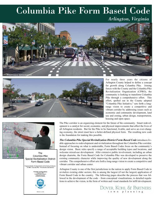
Columbia Pike Form Based Code Arlington, Virginia Proposed Impovement Existing Citizen Planning For nearly three years the citizens of Arlington County helped to define a concept for growth along Columbia Pike. Joining forces with the County and the Columbia Pike Revitalization Organization (CPRO), the community is looking to transform Columbia Pike through a comprehensive effort. This effort, spelled out in the County adopted "Columbia Pike Initiative," sets forth a longrange vision to create a competitive and vibrant corridor by addressing issues such as economic and community development, land use and zoning, urban design, transportation, housing and open space. The Pike corridor is an organizing element for the future of the community. Smart redevelopment is a catalyst for social, economic, and physical improvements that affect the lives of all Arlington residents. But for the Pike to be functional, livable, and serve an ever-changing economy, the street must have a better-defined physical form. The resulting new code is the foundation for making this possible. The Columbia Pike Special Revitalization District Form Based Code introduces livable approaches to redevelopment and revitalization throughout the Columbia Pike corridor. Instead of focusing on what is undesirable, Form Based Codes focus on the community’s design vision. Basic rules specify a range of acceptable building types and locations, and welcome mixed-use development. After extensive public involvement, including an urban design charrette, the Form Based Code for Columbia Pike was developed to preserve the existing community character while improving the quality of new development along the corridor. The comprehensive effort sets forth a long-range vision to create a competitive and vibrant corridor and urban center. Arlington County is one of the first jurisdictions in the nation to apply Form Based Code to revitalize existing older sectors; this is among the largest (if not the largest) application of Form Based Code in the country. The following pages describe the process that was followed in the development of the code – from conceptual visualizations, to detailed regulations to achieve the vision, in the form of written and visual standards for infill development.
- Page 2 and 3: Neighborhood Center Western Gateway
- Page 4: The charrette will probably be look
<strong>Columbia</strong> <strong>Pike</strong> <strong>Form</strong> <strong>Based</strong> <strong>Code</strong><br />
Arlington, Virginia<br />
Proposed Impovement<br />
Existing<br />
Citizen<br />
Planning<br />
For nearly three years the citizens of<br />
Arlington County helped to define a concept<br />
for growth along <strong>Columbia</strong> <strong>Pike</strong>. Joining<br />
forces with the County and the <strong>Columbia</strong> <strong>Pike</strong><br />
Revitalization Organization (CPRO), the<br />
community is looking to transform <strong>Columbia</strong><br />
<strong>Pike</strong> through a comprehensive effort. This<br />
effort, spelled out in the County adopted<br />
"<strong>Columbia</strong> <strong>Pike</strong> Initiative," sets forth a longrange<br />
vision to create a competitive and<br />
vibrant corridor by addressing issues such as<br />
economic and community development, land<br />
use and zoning, urban design, transportation,<br />
housing and open space.<br />
The <strong>Pike</strong> corridor is an organizing element for the future of the community. Smart redevelopment<br />
is a catalyst for social, economic, and physical improvements that affect the lives of<br />
all Arlington residents. But for the <strong>Pike</strong> to be functional, livable, and serve an ever-changing<br />
economy, the street must have a better-defined physical form. The resulting new code<br />
is the foundation for making this possible.<br />
The <strong>Columbia</strong> <strong>Pike</strong> Special Revitalization District <strong>Form</strong> <strong>Based</strong> <strong>Code</strong> introduces livable<br />
approaches to redevelopment and revitalization throughout the <strong>Columbia</strong> <strong>Pike</strong> corridor.<br />
Instead of focusing on what is undesirable, <strong>Form</strong> <strong>Based</strong> <strong>Code</strong>s focus on the community’s<br />
design vision. Basic rules specify a range of acceptable building types and locations, and<br />
welcome mixed-use development. After extensive public involvement, including an urban<br />
design charrette, the <strong>Form</strong> <strong>Based</strong> <strong>Code</strong> for <strong>Columbia</strong> <strong>Pike</strong> was developed to preserve the<br />
existing community character while improving the quality of new development along the<br />
corridor. The comprehensive effort sets forth a long-range vision to create a competitive and<br />
vibrant corridor and urban center.<br />
Arlington County is one of the first jurisdictions in the nation to apply <strong>Form</strong> <strong>Based</strong> <strong>Code</strong> to<br />
revitalize existing older sectors; this is among the largest (if not the largest) application of<br />
<strong>Form</strong> <strong>Based</strong> <strong>Code</strong> in the country. The following pages describe the process that was followed<br />
in the development of the code – from conceptual visualizations, to detailed regulations<br />
to achieve the vision, in the form of written and visual standards for infill development.
Neighborhood Center<br />
Western Gateway<br />
Village Center<br />
The <strong>Columbia</strong> <strong>Pike</strong> Urban Design Charrette, held in September of 2002, was a forum for citizens to<br />
get involved in designing the future of the <strong>Pike</strong>. Citizens gathered in small groups to discuss and<br />
draw ideas for redeveloping the <strong>Pike</strong>, and to build consensus on the ideas that were important to them.<br />
During the charrette week, the design team began to assemble one overall plan, incorporating the “big<br />
ideas” generated by the community. Community members stopped by the studio located on the <strong>Pike</strong>,<br />
offering continual input as the plan progressed. The Illustrative Plan (above) is the result of this<br />
planning process; it shows the hypothetical buildout of the corridor, locating building footprints (new<br />
and existing), open space, and parking areas. The corridor was divided into four study areas, the<br />
Western Gateway, the Neighborhood Center, the Village Center, and the Town Center. Each area has<br />
it’s own unique characteristics and challenges which were addressed.<br />
Quick sketches were done to study buildings that would result from the hypothetical building footprints<br />
in the Illustrative Plan, combined with the proposed height limits in the study areas and potential<br />
architectural regulations of the new code. These sketches were presented to the public, so they<br />
could envision the form and mass of future development. One example, illustrating new buildings in<br />
the Village Center, is shown at left.<br />
At the conclusion of the charrette week, work began on developing the detailed codes and regulating<br />
plans that would lay out the rules for new development. The Town Center Regulating Plan (right)<br />
illustrates the required building line (RBL), the street tree alignment and parking setback lines, and<br />
identifies a street frontage type for each street, which corresponds to written code regulations.
Evolution Over Time...<br />
The sequence of images to the left demonstrates how the form-based<br />
code will affect the character of <strong>Columbia</strong> <strong>Pike</strong> over time. The first<br />
image displays the existing conditions, with a blank white wall facing<br />
<strong>Columbia</strong> <strong>Pike</strong>, and a parking area shown beyond.<br />
In the second image, the corner site has been redeveloped, and glazed<br />
surfaces meet pedestrians on the street passing by. Upper floors are<br />
used for office or residential purposes, adding a population to enliven<br />
the surrounding streets. The street treees have grown to maturation,<br />
providing a continuous tree canopy for pedestrians.<br />
In the third image, buildings fill in the former parking lot to the left of<br />
the corner building, completing the continuous building facade along<br />
<strong>Columbia</strong> <strong>Pike</strong>. Parking is now provided to the rear of buildings,<br />
away from the street. Enhanced public transit can reduce the number<br />
of parking spaces required for infill development.<br />
Town Center
The charrette will probably be looked back upon as a historic event in<br />
the redevelopment and revitalization of <strong>Columbia</strong> <strong>Pike</strong>.<br />
<strong>Columbia</strong> <strong>Pike</strong> Master Plan<br />
and <strong>Form</strong> <strong>Based</strong> <strong>Code</strong><br />
Location:<br />
Project Area:<br />
Client:<br />
Arlington, Virginia<br />
3.5 mile section of<br />
<strong>Columbia</strong> <strong>Pike</strong><br />
Arlington County<br />
Charrette Team: Victor Dover<br />
Joseph Kohl<br />
Margaret Marshall<br />
James Dougherty<br />
Amy Groves<br />
Ibrahim Mohasseb<br />
Subconsultants:<br />
Geoffrey Ferrell Associates<br />
coding<br />
UrbanAdvantage<br />
imaging<br />
VOA Associates<br />
local assistance<br />
Status:<br />
The Arlington County Board approved the<br />
<strong>Columbia</strong> <strong>Pike</strong> <strong>Form</strong> <strong>Based</strong> <strong>Code</strong> in February<br />
2003. The first project under the form <strong>Based</strong><br />
<strong>Code</strong> has been approved – the project will be the<br />
first mixed-use development project in the<br />
<strong>Columbia</strong> <strong>Pike</strong> corridor in more than 40 years.<br />
Street Standards were developed for the entire study area. These standards illustrate<br />
the principles of the code, demonstrating various criteria including how wide<br />
the streetspace (the distance between buildings) should be, how many lanes of traffic<br />
there should be, and where street trees and on-street parking should be located.<br />
1571 Sunset Drive Coral Gables, FL 33143<br />
phone: 305-666-0446 fax: 305-666-0360 www.doverkohl.com


