Application of New Pedestrian Level of Service Measures - sacog
Application of New Pedestrian Level of Service Measures - sacog Application of New Pedestrian Level of Service Measures - sacog
Application of New Pedestrian Level of Service Measures SACOG Breadth of Factors Considered The MMLOS model considers a wide variety of factors in determining pedestrian LOS that is unmatched by any other model we encountered in the literature review. The fact that the MMLOS model evaluates bicycle, auto, and transit LOS also makes it appealing to a wider audience. Broad Based Acceptance and Use The MMLOS model is now the standard pedestrian LOS model used in the 2010 Highway Capacity Manual. Therefore, it is likely to be used by more professionals across the county. As it becomes more widely used, it will become more accessible for users of different technical ability levels. Model Design and Customization The PPM point system is simple and easy to understand, making it accessible to engineers, modelers, planners, and advocates alike. The PPM model is also highly customizable. Because it is a simple point system, elements can be added, removed, or adjusted to take into account additional factors that may not be considered in the base model. Model Presentation and Supporting Documents The MMLOS model and the PPM model both offer excellent background documents that clearly describe the data inputs needed and the methodology used to generate a LOS score. While the MMLOS model is much more complex than the PPM model, the MMLOS model supporting documents are thorough and would be extremely useful in replicating the analysis in different locations with different street treatments. Issue Date: June 2011 8
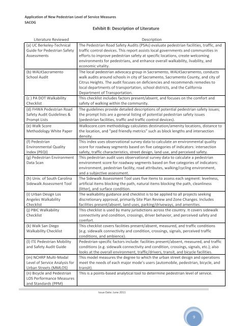
Application of New Pedestrian Level of Service Measures SACOG Exhibit B: Description of Literature Literature Reviewed (a) UC Berkeley‐Technical Guide for Pedestrian Safety Assessments (b) WALKSacramento School Audit (c ) PA DOT Walkability Checklist (d) FHWA Pedestrian Road Safety Audit Guidelines & Prompt Lists (e) Walk Score Methodology White Paper (f) Pedestrian Environmental Quality Index (PEQI) (g) Pedestrian Environment Data Scan (h) Univ. of South Carolina Sidewalk Assessment Tool (i) Urban Design Los Angeles Walkability Checklist (j) PBIC Walkability Checklist (k) Walk San Diego Walkability Checklist (l) ITE Pedestrian Mobility and Safety Audit Guide (m) NCHRP Multi‐Modal Level of Service Analysis for Urban Streets (MMLOS) (n) Bicycle and Pedestrian LOS Performance Measures and Standards (PPM) Description The Pedestrian Road Safety Audits (PSAs) evaluate pedestrian facilities, traffic, and traffic control devices. This report assists local governments and communities in efforts to improve pedestrian safety at specific locations, create welcoming environments for pedestrians, and enhance overall walkability, livability, and economic vitality. The local pedestrian advocacy group in Sacramento, WALKSacramento, conducts walk audits around schools in city of Sacramento, Sacramento County, and city of Citrus Heights. The audit focuses on deficiencies and recommends remedies to local departments of transportation, school districts, and the California Department of Transportation. This checklist includes factors present/absent, and focuses on the comfort and safety of walking within the community. The guidelines provide detailed descriptions of potential pedestrian safety issues; the prompt lists are a general listing of potential pedestrian safety issues (pedestrian facilities, traffic and traffic control devices). Walkscore.com methodology calculates destination/amenity locations, distance to the location, and "ped friendly metrics" such as block lengths and intersection density. This index uses observational survey data to calculate an environmental quality score for roadway segments based on five categories of indicators: intersection safety, traffic characteristics, street design, land use, and perceived safety. This pedestrian audit uses observational survey data to calculate a pedestrian environment score for roadway segments based on five categories of indicators: environment, pedestrian facility, road attributes, walking/cycling environment, and a subjective assessment. The Sidewalk Assessment Tool uses five items to assess each segment: levelness, artificial items blocking the path, natural items blocking the path, cleanliness (litter), and surface condition. The walkability guidance and checklist is to be applied to all projects seeking discretionary approval, primarily Site Plan Review and Zone Changes. Includes facilities present/absent, land uses, parking/driveways, and amenities. This checklist is used by many jurisdictions across the country. It covers sidewalk connectivity and condition, crossings, driver behavior, and perceived safety and comfort. This checklist covers facilities present/absent, measured, and traffic conditions (e.g. sidewalk connectivity and condition, crossings, signals, perceived traffic conditions, and ambience). Pedestrian‐specific factors include: facilities present/absent, measured, and traffic conditions (e.g. sidewalk connectivity and condition, crossings, signals, etc.); also looks at the overall environment, traffic/drivers, transit, and bicycle facilities. This model measures the degree to which the urban street design and operations meet the needs of each major mode’s users (automobile, pedestrian, bicycle, and transit). This is a points‐based analytical tool to determine pedestrian level of service. Issue Date: June 2011 9
- Page 1 and 2: Application of New Pedestrian Level
- Page 3 and 4: Application of New Pedestrian Level
- Page 5 and 6: Application of New Pedestrian Level
- Page 7: 3. Literature Review of Existing An
- Page 11 and 12: Application of New Pedestrian Level
- Page 13 and 14: Application of New Pedestrian Level
- Page 15 and 16: Application of New Pedestrian Level
- Page 17 and 18: Application of New Pedestrian Level
- Page 19 and 20: Application of New Pedestrian Level
- Page 21 and 22: Application of New Pedestrian Level
- Page 23 and 24: Application of New Pedestrian Level
- Page 25 and 26: Application of New Pedestrian Level
- Page 27 and 28: Application of New Pedestrian Level
- Page 29 and 30: Application of New Pedestrian Level
- Page 31 and 32: Application of New Pedestrian Level
- Page 33 and 34: Application of New Pedestrian Level
- Page 35 and 36: Application of New Pedestrian Level
- Page 37 and 38: Application of New Pedestrian Level
- Page 39 and 40: Application of New Pedestrian Level
- Page 41 and 42: Application of New Pedestrian Level
- Page 43 and 44: Application of New Pedestrian Level
- Page 45 and 46: Application of New Pedestrian Level
- Page 47 and 48: Application of New Pedestrian Level
- Page 49 and 50: Application of New Pedestrian Level
- Page 51 and 52: Application of New Pedestrian Level
- Page 53 and 54: Application of New Pedestrian Level
- Page 55 and 56: Application of New Pedestrian Level
- Page 57 and 58: Application of New Pedestrian Level
<strong>Application</strong> <strong>of</strong> <strong>New</strong> <strong>Pedestrian</strong> <strong>Level</strong> <strong>of</strong> <strong>Service</strong> <strong>Measures</strong><br />
SACOG<br />
Exhibit B: Description <strong>of</strong> Literature<br />
Literature Reviewed<br />
(a) UC Berkeley‐Technical<br />
Guide for <strong>Pedestrian</strong> Safety<br />
Assessments<br />
(b) WALKSacramento<br />
School Audit<br />
(c ) PA DOT Walkability<br />
Checklist<br />
(d) FHWA <strong>Pedestrian</strong> Road<br />
Safety Audit Guidelines &<br />
Prompt Lists<br />
(e) Walk Score<br />
Methodology White Paper<br />
(f) <strong>Pedestrian</strong><br />
Environmental Quality<br />
Index (PEQI)<br />
(g) <strong>Pedestrian</strong> Environment<br />
Data Scan<br />
(h) Univ. <strong>of</strong> South Carolina<br />
Sidewalk Assessment Tool<br />
(i) Urban Design Los<br />
Angeles Walkability<br />
Checklist<br />
(j) PBIC Walkability<br />
Checklist<br />
(k) Walk San Diego<br />
Walkability Checklist<br />
(l) ITE <strong>Pedestrian</strong> Mobility<br />
and Safety Audit Guide<br />
(m) NCHRP Multi‐Modal<br />
<strong>Level</strong> <strong>of</strong> <strong>Service</strong> Analysis for<br />
Urban Streets (MMLOS)<br />
(n) Bicycle and <strong>Pedestrian</strong><br />
LOS Performance <strong>Measures</strong><br />
and Standards (PPM)<br />
Description<br />
The <strong>Pedestrian</strong> Road Safety Audits (PSAs) evaluate pedestrian facilities, traffic, and<br />
traffic control devices. This report assists local governments and communities in<br />
efforts to improve pedestrian safety at specific locations, create welcoming<br />
environments for pedestrians, and enhance overall walkability, livability, and<br />
economic vitality.<br />
The local pedestrian advocacy group in Sacramento, WALKSacramento, conducts<br />
walk audits around schools in city <strong>of</strong> Sacramento, Sacramento County, and city <strong>of</strong><br />
Citrus Heights. The audit focuses on deficiencies and recommends remedies to<br />
local departments <strong>of</strong> transportation, school districts, and the California<br />
Department <strong>of</strong> Transportation.<br />
This checklist includes factors present/absent, and focuses on the comfort and<br />
safety <strong>of</strong> walking within the community.<br />
The guidelines provide detailed descriptions <strong>of</strong> potential pedestrian safety issues;<br />
the prompt lists are a general listing <strong>of</strong> potential pedestrian safety issues<br />
(pedestrian facilities, traffic and traffic control devices).<br />
Walkscore.com methodology calculates destination/amenity locations, distance to<br />
the location, and "ped friendly metrics" such as block lengths and intersection<br />
density.<br />
This index uses observational survey data to calculate an environmental quality<br />
score for roadway segments based on five categories <strong>of</strong> indicators: intersection<br />
safety, traffic characteristics, street design, land use, and perceived safety.<br />
This pedestrian audit uses observational survey data to calculate a pedestrian<br />
environment score for roadway segments based on five categories <strong>of</strong> indicators:<br />
environment, pedestrian facility, road attributes, walking/cycling environment,<br />
and a subjective assessment.<br />
The Sidewalk Assessment Tool uses five items to assess each segment: levelness,<br />
artificial items blocking the path, natural items blocking the path, cleanliness<br />
(litter), and surface condition.<br />
The walkability guidance and checklist is to be applied to all projects seeking<br />
discretionary approval, primarily Site Plan Review and Zone Changes. Includes<br />
facilities present/absent, land uses, parking/driveways, and amenities.<br />
This checklist is used by many jurisdictions across the country. It covers sidewalk<br />
connectivity and condition, crossings, driver behavior, and perceived safety and<br />
comfort.<br />
This checklist covers facilities present/absent, measured, and traffic conditions<br />
(e.g. sidewalk connectivity and condition, crossings, signals, perceived traffic<br />
conditions, and ambience).<br />
<strong>Pedestrian</strong>‐specific factors include: facilities present/absent, measured, and traffic<br />
conditions (e.g. sidewalk connectivity and condition, crossings, signals, etc.); also<br />
looks at the overall environment, traffic/drivers, transit, and bicycle facilities.<br />
This model measures the degree to which the urban street design and operations<br />
meet the needs <strong>of</strong> each major mode’s users (automobile, pedestrian, bicycle, and<br />
transit).<br />
This is a points‐based analytical tool to determine pedestrian level <strong>of</strong> service.<br />
Issue Date: June 2011<br />
9


