

IWMP-11 - Commissionerate of Rural Development Gujarat State ...
IWMP-11 - Commissionerate of Rural Development Gujarat State ...
IWMP-11 - Commissionerate of Rural Development Gujarat State ...

You also want an ePaper? Increase the reach of your titles
YUMPU automatically turns print PDFs into web optimized ePapers that Google loves.
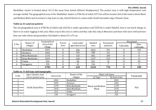
PIA: DWDU, Amreli<br />
Shedubhar cluster is located about 10-12 Km away from Amreli (District Headquarter). The project area is with high temperature and<br />
average rainfall. The geographical area <strong>of</strong> the Shedubhar cluster is 6786 Ha <strong>of</strong> which 5271 Ha will be treated. Soil <strong>of</strong> this land is about Black<br />
and Medium Black and its texture is clay loam to clay. Amreli District is comes under South Saurashtra Agro Climatic Zone.<br />
Table no. 8: Land use pattern<br />
The net geographical area is 6786 Ha <strong>of</strong> which only 620 Ha is under agriculture and 5220 Ha is under Rainfed. Area is not much sloppy so<br />
there is no water logging in this area. Main crop in this area is cotton and they take this only in Monsoon and those who have well and bore<br />
they saw only wheat and groundnut. Soil depth is about 25 t o75 cm.<br />
S. No.<br />
Names <strong>of</strong><br />
villages<br />
Geographical<br />
Area <strong>of</strong> the<br />
village<br />
Forest<br />
Area<br />
Land under<br />
agricultural use<br />
Rainfed<br />
area<br />
Permanent<br />
pastures<br />
Cultivable<br />
Wasteland<br />
Noncultivable<br />
1 Shedubhar 2501 0 206 1852 291 0 152<br />
2 Haripura 1095 0 103 928 64 0 0<br />
3 Mota Machiyala <strong>11</strong>70 0 135 856 169 0 0<br />
4 Nana Machiyala 1476 0 126 <strong>11</strong>37 213 0 0<br />
5 Timba 314 0 28 251 12 0 23<br />
6 Suragpura 230 0 22 196 7 0 5<br />
6786 0 620 5220 756 0 180<br />
Table no. 9: Soil type and topography<br />
S. No.<br />
Agro-climatic zone<br />
Names <strong>of</strong> the<br />
Major soil types<br />
Area in ha<br />
covers project area<br />
villages<br />
a) Type b) Area in ha<br />
1<br />
2501 Shedubhar<br />
2501<br />
2 1095 Haripura 1095<br />
3 <strong>11</strong>70 Mota Machiyala Black and Medium <strong>11</strong>70<br />
South Saurashtra<br />
4 1476 Nana Machiyala Black<br />
1476<br />
5 314 Timba 314<br />
6 230 Suragpura 230<br />
Topography<br />
Flat<br />
District Watershed <strong>Development</strong> Unit, Amreli 17


