Hafen Titel - Rostock Port
Hafen Titel - Rostock Port
Hafen Titel - Rostock Port

You also want an ePaper? Increase the reach of your titles
YUMPU automatically turns print PDFs into web optimized ePapers that Google loves.
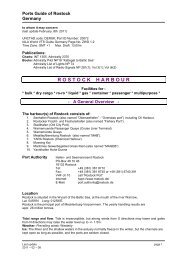
INFORMATION<br />
<strong>Rostock</strong> <strong>Port</strong><br />
UNCTAD code:<br />
DERSK;<br />
<strong>Port</strong> ID Number:<br />
20072<br />
IALA World VTS<br />
Guide Germany Page<br />
No. ZWD 1-2<br />
Time Zone: GMT +1<br />
Max. Draft: 13,00m<br />
Publications:<br />
Charts: INT 1355,<br />
Admiralty 2370<br />
Books:<br />
Admiralty Pilot NP18<br />
”Kattegat to<br />
Baltic Sea”<br />
Admiralty List of<br />
Lights NP 74<br />
Admiralty List of<br />
Radio Signals<br />
NP 281(1);<br />
Vol 3(1); Vol (6(2)<br />
<strong>Port</strong> Authority<br />
<strong>Hafen</strong>- und Seemannsamt <strong>Rostock</strong><br />
PO-Box 481046, 18132 <strong>Rostock</strong><br />
Phone: +49 (0) 381 – 38187-10<br />
Fax: +49 (0) 381 – 38187-35<br />
or +49 (0) 381 – 6740291<br />
VHF ch 10 call ”<strong>Rostock</strong> <strong>Port</strong>”<br />
Internet: hppt://www.rostock.de/<br />
E-Mail: port.authority @ rostock.de<br />
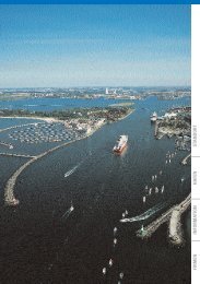
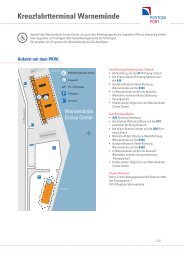
Location<br />
<strong>Rostock</strong> is situated in the W-part of the Baltic<br />
Sea, at the mouth of the river Warnow,<br />
Lat: 54°09' N, Long: 012°06' E.<br />
<strong>Rostock</strong> is the principal port of Mecklenburg-<br />
Vorpommern. The yearly handling results are<br />
appr. 26 million tonnes.<br />
Tidal range and flow<br />
Tide is imperceptible, but strong winds from<br />
S directions may lower and gales from<br />
N directions may raise the water level<br />
up to +/– 1.5 m.<br />
Weather<br />
Prevailing winds: Westerly<br />
Ice: The River and the shallow waters in the<br />
estuary normally freeze in the winter, but the<br />
channels are kept open as long as possible,<br />
and the ports are seldom closed.<br />
Density: The water in the estuary and in the<br />
port of <strong>Rostock</strong> is fresh to brackish with a<br />
density varying from 1006 to 1009 kg/m³.<br />
Restrictions and Shipmax<br />
No obstacles, no locks, bridges etc.;<br />
no restrictions for entering at night normally.<br />
Generally the <strong>Port</strong> of <strong>Rostock</strong> can accommodate<br />
vessels of LOA 295 m and or beam 45 m ;<br />
draught 13,00 m, but vessels exceeding<br />
LOA 230 m and or beam 36 m and or draught<br />
12,00 m are requested to obtain permission<br />
from Waterway and Shipping Board.<br />
Vessels bound for Fracht- und Fischereihafen<br />
exceeding LOA 125 m and or beam 17,5 m and<br />
or draught 7,50 m are also requested to obtain<br />
permission from Waterway and Shipping<br />
Board.<br />
Anchorages<br />
In the roads, 4–6 nm NW of Warnemunde,<br />
there are two recommended anchorages in<br />
depths of 13–17 m, bottom mud and sand.<br />
They are unsheltered from W, N and NE<br />
winds. Anchorage No. 2 is reserved for tankers,<br />
vessels with dangerous cargo and for<br />
bunkering; Anchorage No.1 for other vessels.<br />
Traffic Schemes<br />
Sea buoys, fairways and channels:<br />
River Warnow is approached from the Bay of<br />
Mecklenburg through a buoyed and lighted<br />
fairway channel, 5nm in length, 14,50m depth,<br />
leading to Warnemuende and a sea channel<br />
leading to Seehafen <strong>Rostock</strong>.<br />
Traffic Organisation Service (VTS Centre)<br />
”Warnemuende Traffic”, situated in Warnemuende,<br />
continuously controls all movements<br />
between the approach buoy and the <strong>Rostock</strong><br />
harbours and should be contacted via VHF ch<br />
73 as soon as possible (normally two hours<br />
before approach buoy).<br />
Phone: +49 (0) 381 – 206718-41<br />
Fax: +49 (0) 381 – 206718-45<br />
50–51