The Past and the Future of Flood Management in the Eastern ... - INBO
The Past and the Future of Flood Management in the Eastern ... - INBO
The Past and the Future of Flood Management in the Eastern ... - INBO
You also want an ePaper? Increase the reach of your titles
YUMPU automatically turns print PDFs into web optimized ePapers that Google loves.
disputes with Eritrea. <strong>The</strong>re are no real-time or virtual real-time report<strong>in</strong>g stations <strong>in</strong> <strong>the</strong><br />
<strong>Eastern</strong> Nile bas<strong>in</strong> that are currently useful for flood forecast<strong>in</strong>g. Some stations have<br />
manually observed staff gauges <strong>and</strong> many have chart recorders.<br />
Sudan:<br />
With<strong>in</strong> <strong>the</strong> Sudan, ma<strong>in</strong> tributaries are those flow<strong>in</strong>g from Ethiopia already noted above:<br />
<strong>the</strong> D<strong>in</strong>der <strong>and</strong> Rahad which jo<strong>in</strong> <strong>the</strong> right bank <strong>of</strong> <strong>the</strong> Blue Nile, <strong>and</strong> <strong>the</strong> Angareb <strong>and</strong><br />
Goang which jo<strong>in</strong> <strong>the</strong> left bank <strong>of</strong> <strong>the</strong> Atbara. As noted previously, <strong>the</strong> White Nile jo<strong>in</strong>s<br />
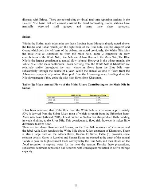
<strong>the</strong> Blue Nile at Khartoum to from <strong>the</strong> Ma<strong>in</strong> Nile. Table 2 compares <strong>the</strong> flow<br />
contributions <strong>of</strong> <strong>the</strong> White Nile, Blue Nile <strong>and</strong> Atbara Rivers to <strong>the</strong> Ma<strong>in</strong> Nile; <strong>The</strong> Blue<br />
Nile is <strong>the</strong> largest contributor to annual flow volume. However <strong>in</strong> <strong>the</strong> w<strong>in</strong>ter months <strong>the</strong><br />
White Nile is <strong>the</strong> ma<strong>in</strong> contributor. Flows deriv<strong>in</strong>g from <strong>the</strong> White Nile at Khartoum are<br />
relatively stable throughout <strong>the</strong> year, where as flows from <strong>the</strong> Blue Nile vary<br />
substantially through <strong>the</strong> course <strong>of</strong> a year, While <strong>the</strong> annual volume <strong>of</strong> flows from <strong>the</strong><br />
Atbara are comparatively m<strong>in</strong>or, flood peak from <strong>the</strong> Atbara aggravate flood<strong>in</strong>g along <strong>the</strong><br />
Nile downstream if <strong>the</strong>y co<strong>in</strong>cide with high flows from Khartoum.<br />
Table (2): Mean Annual Flows <strong>of</strong> <strong>the</strong> Ma<strong>in</strong> Rivers Contribut<strong>in</strong>g to <strong>the</strong> Ma<strong>in</strong> Nile <strong>in</strong><br />
Sudan<br />
It has been estimated that <strong>of</strong> <strong>the</strong> flow from <strong>the</strong> White Nile at Khartoum, approximately<br />
50% is derived from <strong>the</strong> Sobat River, most <strong>of</strong> which is run<strong>of</strong>f from <strong>the</strong> Ethiopian Baro-<br />
Akob sub- bas<strong>in</strong> (Ahmed, 2006). Local ra<strong>in</strong>fall <strong>in</strong> Sudan can also produce flash flood<strong>in</strong>g<br />
<strong>in</strong> wadis dra<strong>in</strong><strong>in</strong>g to <strong>the</strong> River Nile. This contributes to flood risk; however it makes little<br />
difference to river flows.<br />
<strong>The</strong>re are two dams, Roseires <strong>and</strong> Sennar, on <strong>the</strong> Blue Nile upstream <strong>of</strong> Khartoum, <strong>and</strong><br />
<strong>the</strong> Jebel Aulia Dam regulates <strong>the</strong> White Nile about 32 km upstream <strong>of</strong> Khartoum. <strong>The</strong>re<br />
is also a large dam on <strong>the</strong> Atbara River, Kashm El Girba, Table (3) provides some<br />
relevant details. Gates <strong>in</strong> Roseires <strong>and</strong> Sennar Dams are opened at <strong>the</strong> onset <strong>of</strong> <strong>the</strong> annual<br />
floods to pass <strong>the</strong> high sediment loads conveyed by <strong>the</strong> Blue Nile, <strong>and</strong> <strong>the</strong>n closed on <strong>the</strong><br />
flood recession to capture water for <strong>the</strong> next dry season. Despite <strong>the</strong>se precautions,<br />
substantial sediment deposition has occurred with consequent reduction <strong>in</strong> active storage<br />
capacity.<br />
8


