The Past and the Future of Flood Management in the Eastern ... - INBO
The Past and the Future of Flood Management in the Eastern ... - INBO
The Past and the Future of Flood Management in the Eastern ... - INBO

You also want an ePaper? Increase the reach of your titles
YUMPU automatically turns print PDFs into web optimized ePapers that Google loves.
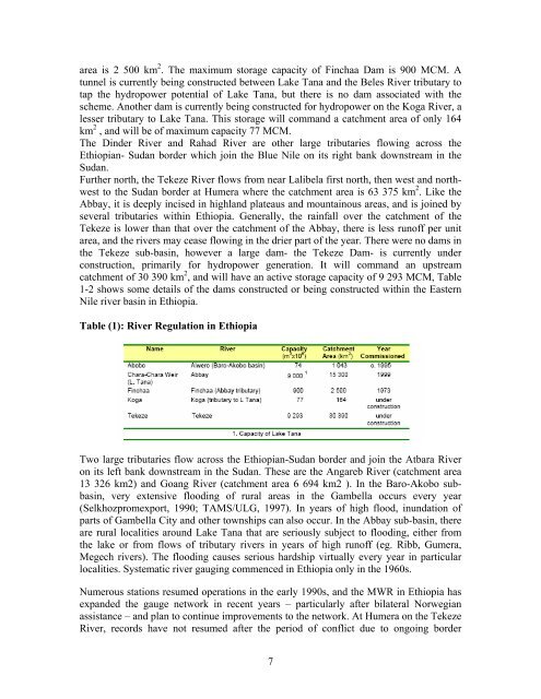
area is 2 500 km 2 . <strong>The</strong> maximum storage capacity <strong>of</strong> F<strong>in</strong>chaa Dam is 900 MCM. A<br />
tunnel is currently be<strong>in</strong>g constructed between Lake Tana <strong>and</strong> <strong>the</strong> Beles River tributary to<br />
tap <strong>the</strong> hydropower potential <strong>of</strong> Lake Tana, but <strong>the</strong>re is no dam associated with <strong>the</strong><br />
scheme. Ano<strong>the</strong>r dam is currently be<strong>in</strong>g constructed for hydropower on <strong>the</strong> Koga River, a<br />
lesser tributary to Lake Tana. This storage will comm<strong>and</strong> a catchment area <strong>of</strong> only 164<br />
km 2 , <strong>and</strong> will be <strong>of</strong> maximum capacity 77 MCM.<br />
<strong>The</strong> D<strong>in</strong>der River <strong>and</strong> Rahad River are o<strong>the</strong>r large tributaries flow<strong>in</strong>g across <strong>the</strong><br />
Ethiopian- Sudan border which jo<strong>in</strong> <strong>the</strong> Blue Nile on its right bank downstream <strong>in</strong> <strong>the</strong><br />
Sudan.<br />
Fur<strong>the</strong>r north, <strong>the</strong> Tekeze River flows from near Lalibela first north, <strong>the</strong>n west <strong>and</strong> northwest<br />
to <strong>the</strong> Sudan border at Humera where <strong>the</strong> catchment area is 63 375 km 2 . Like <strong>the</strong><br />
Abbay, it is deeply <strong>in</strong>cised <strong>in</strong> highl<strong>and</strong> plateaus <strong>and</strong> mounta<strong>in</strong>ous areas, <strong>and</strong> is jo<strong>in</strong>ed by<br />
several tributaries with<strong>in</strong> Ethiopia. Generally, <strong>the</strong> ra<strong>in</strong>fall over <strong>the</strong> catchment <strong>of</strong> <strong>the</strong><br />
Tekeze is lower than that over <strong>the</strong> catchment <strong>of</strong> <strong>the</strong> Abbay, <strong>the</strong>re is less run<strong>of</strong>f per unit<br />
area, <strong>and</strong> <strong>the</strong> rivers may cease flow<strong>in</strong>g <strong>in</strong> <strong>the</strong> drier part <strong>of</strong> <strong>the</strong> year. <strong>The</strong>re were no dams <strong>in</strong><br />
<strong>the</strong> Tekeze sub-bas<strong>in</strong>, however a large dam- <strong>the</strong> Tekeze Dam- is currently under<br />
construction, primarily for hydropower generation. It will comm<strong>and</strong> an upstream<br />
catchment <strong>of</strong> 30 390 km 2 , <strong>and</strong> will have an active storage capacity <strong>of</strong> 9 293 MCM, Table<br />
1-2 shows some details <strong>of</strong> <strong>the</strong> dams constructed or be<strong>in</strong>g constructed with<strong>in</strong> <strong>the</strong> <strong>Eastern</strong><br />
Nile river bas<strong>in</strong> <strong>in</strong> Ethiopia.<br />
Table (1): River Regulation <strong>in</strong> Ethiopia<br />
Two large tributaries flow across <strong>the</strong> Ethiopian-Sudan border <strong>and</strong> jo<strong>in</strong> <strong>the</strong> Atbara River<br />
on its left bank downstream <strong>in</strong> <strong>the</strong> Sudan. <strong>The</strong>se are <strong>the</strong> Angareb River (catchment area<br />
13 326 km2) <strong>and</strong> Goang River (catchment area 6 694 km2 ). In <strong>the</strong> Baro-Akobo subbas<strong>in</strong>,<br />
very extensive flood<strong>in</strong>g <strong>of</strong> rural areas <strong>in</strong> <strong>the</strong> Gambella occurs every year<br />
(Selkhozpromexport, 1990; TAMS/ULG, 1997). In years <strong>of</strong> high flood, <strong>in</strong>undation <strong>of</strong><br />
parts <strong>of</strong> Gambella City <strong>and</strong> o<strong>the</strong>r townships can also occur. In <strong>the</strong> Abbay sub-bas<strong>in</strong>, <strong>the</strong>re<br />
are rural localities around Lake Tana that are seriously subject to flood<strong>in</strong>g, ei<strong>the</strong>r from<br />
<strong>the</strong> lake or from flows <strong>of</strong> tributary rivers <strong>in</strong> years <strong>of</strong> high run<strong>of</strong>f (eg. Ribb, Gumera,<br />
Megech rivers). <strong>The</strong> flood<strong>in</strong>g causes serious hardship virtually every year <strong>in</strong> particular<br />
localities. Systematic river gaug<strong>in</strong>g commenced <strong>in</strong> Ethiopia only <strong>in</strong> <strong>the</strong> 1960s.<br />
Numerous stations resumed operations <strong>in</strong> <strong>the</strong> early 1990s, <strong>and</strong> <strong>the</strong> MWR <strong>in</strong> Ethiopia has<br />
exp<strong>and</strong>ed <strong>the</strong> gauge network <strong>in</strong> recent years – particularly after bilateral Norwegian<br />
assistance – <strong>and</strong> plan to cont<strong>in</strong>ue improvements to <strong>the</strong> network. At Humera on <strong>the</strong> Tekeze<br />
River, records have not resumed after <strong>the</strong> period <strong>of</strong> conflict due to ongo<strong>in</strong>g border<br />
7