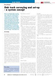
HERGiE® tRack MEasuREMEnt systEM
HERGiE® tRack MEasuREMEnt systEM
HERGiE® tRack MEasuREMEnt systEM

Create successful ePaper yourself
Turn your PDF publications into a flip-book with our unique Google optimized e-Paper software.
adjustment process in 2 steps<br />
Rough adjustment:<br />
HERGIE ® track surveying trolley<br />
The track surveying trolley constitutes<br />
• An inclination sensor<br />
• A length sensor for the gauge<br />
• A reflector<br />
• An optional rail inclination sensor<br />
Thanks to its light weight, it can be easily transported by<br />
one person.<br />
RTE Technologie GmbH<br />
Dipl.-Ing. Dr. Helge Grafinger<br />
Teisenberggasse 25<br />
5020 Salzburg/Austria<br />
Tel. +43 662 421066<br />
info-rte@rhombergbau.at<br />
www.rhombergrail.com<br />
hergie ®<br />
precision<br />
track measurement<br />
stability<br />
system<br />
safety<br />
With the help of a mechanical lift-adjustment device,<br />
the position and height of the track are aligned to a<br />
precision of +/- 2 mm.<br />
rte technologie gmbH, Salzburg<br />
Since August 2009 RTE’s developments have expanded the competence profile of the Rhomberg Rail Group in the area of<br />
railway track systems and measuring technology.<br />
Fine adjustment:<br />
The team consists of a wide range of expertise, which includes construction engineers, surveyors, electronic engineers and<br />
software engineers. They develop and optimise complex systems for a variety of specialised disciplines.<br />
The core competences of RTE Technologie GmbH is railway track systems (slab track construction and equipment and the<br />
rehabilitation of tracks and tunnels) as well as the development of surveying systems (track surveying and geomonitoring<br />
systems). All these developments are characterised by their practical application. They have been tested and applied to<br />
in-house projects for the Rhomberg Rail Group.<br />
RTE Technologie GmbH also develops solutions in other technical areas (mechanical construction, software<br />
programming, geometry tasks, digital image processing, and microprocessor control systems) to outside companies.<br />
Our office in Salzburg is fully equipped with a test railway track and the necessary infrastructure to support CAD, software<br />
and electronic developments.<br />
The track is moved manually into the final position and<br />
then fixed. Each individual position is then documented<br />
by the software. Subsequently, evidence of the accuracy<br />
of the adjusted track is always available.<br />
RHOMBERG rail
precision with a system: hergie ®<br />
hergie ® Software<br />
Modern railway technology constantly faces new<br />
challenges: trains are becoming more powerful, faster<br />
and the intervals between them, ever shorter. The demands<br />
on the infrastructure are rising in parallel.<br />
The innovative Hergie ® track surveying system was<br />
developed as part of the high-speed Cologne-Frankfurt<br />
(Germany) rail project by Rhomberg Rail in cooperation<br />
with the Bahnbau Wels subsidiary. Since then its high<br />
quality has substantiated itself in a variety of other<br />
projects.<br />
This online measuring system for the adjustment and<br />
documentation of track condition, compromises of<br />
tachymeter-controlled track surveying trolley, which<br />
optimally measures track position, cant, gauge and rail<br />
inclination.<br />
The measured data are compared “online” with the<br />
pre-specified values for height, position and alignment.<br />
Deviations to these values are shown in real-time on the<br />
user’s monitor.<br />
This means that they can be immediately and accurately<br />
detected to be rectified on the spot.<br />
The “heart” of the Hergie ® track measurement system is<br />
the software developed by RTE. It is available in<br />
English and Spanish.<br />
The system is based on a highly accurate, threedimensional<br />
single position.<br />
At each measuring point, a total of five values are<br />
measured: the coordinates in three dimensions, cant and<br />
gauge.<br />
All further required parameters can be derived from<br />
these values. Moreover, it is also possible to monitor the<br />
entire inner track geometry.<br />
As the precision of the derived parameters depends<br />
directly on the accuracy of the measured data, only the<br />
best quality sensors are used.<br />
The basic prerequirements in describing track geometry<br />
using coordinates are:<br />
• An accurate and stable reference-point network<br />
• Accurate measurements of coordinates at<br />
individual points<br />
Longwave errors (wavelengths that are greater than the<br />
distances between the positions of the instruments) are<br />
directly proportional to quality of the reference-point<br />
network.<br />
In order to avoid the impact of longwaves, we<br />
recommend that the reference-point network be<br />
measured with a highly accurate, tachymeter-controlled<br />
method. Mobile pillars containing a centring device is<br />
recommended. They are also used to position the<br />
tachymeter while the tracks are being aligned.<br />
The reference-point network can also be used to verify<br />
the track alignment.<br />
Individual track alignment points are measured using a<br />
precision tachymeter (direction angle ≥ 0.3 mgon). The<br />
relative accuracy between two reference points at a distance<br />
of approx. 60 m is subsequently below 0.5 mm.<br />
The displayed parameters are shown for each individual<br />
position of the track surveying trolley.<br />
The Hergie ® surveying system requires the following:<br />
• a positioned and orientated total station in the<br />
coordinate system of the reference-point network<br />
• Geometry specified according to axis, gradients and<br />
cant<br />
In order to continuously provide the most accurate<br />
results, all sensors, including the tachymeter have to be<br />
regularly calibrated. The software is compatible and supports<br />
regular calibration.<br />
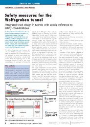
Picture: The geometric height and direction relations are<br />
shown at a single position of the track surveying trolley.<br />
An inclination towards the centre of the track (longitudinal<br />
inclination) is not taken into consideration. For a<br />
standard track width (1.435 mm) the inclination in the<br />
graphic is based on 1.500 mm (distance between the<br />
two rail centres).