Ensuring Sustainability in Brownfield Revitalisation as PDF
Ensuring Sustainability in Brownfield Revitalisation as PDF
Ensuring Sustainability in Brownfield Revitalisation as PDF

You also want an ePaper? Increase the reach of your titles
YUMPU automatically turns print PDFs into web optimized ePapers that Google loves.
Determ<strong>in</strong><strong>in</strong>g Environmental Goals<br />
Factors for develop<strong>in</strong>g a suitable environmental profile for a project <strong>in</strong>clude:<br />
a) The actual and the desired type of liv<strong>in</strong>g/work<strong>in</strong>g environment<br />
The functional spatial development characteristics of an area, such <strong>as</strong><br />
the functions and degree of mixed use, the density, the user-<strong>in</strong>tensity<br />
and accessibility, affect the opportunities and restrictions for achiev<strong>in</strong>g<br />
environmental objectives. The correlation between area characteristics<br />
and quality <strong>as</strong>pects can be found <strong>in</strong> area profiles. To determ<strong>in</strong>e the<br />
actual and desired liv<strong>in</strong>g/work<strong>in</strong>g environments, the municipal urban<br />
plann<strong>in</strong>g policy, together with the economic and hous<strong>in</strong>g policies, offers<br />
po<strong>in</strong>ts of departure and descriptions. For example, Tilburg <strong>in</strong>troduced<br />
hous<strong>in</strong>g profiles <strong>in</strong> its WoonVisie 2002. Furthermore, these are<strong>as</strong> of<br />
policy focus <strong>in</strong>cre<strong>as</strong><strong>in</strong>gly on qualitative objectives <strong>in</strong> respect of safety,<br />
susta<strong>in</strong>ability, etc. Through careful consultation it is possible to make<br />
relatively e<strong>as</strong>y l<strong>in</strong>ks between these different profiles.<br />
b) Location-specific circumstances<br />
The traffic and transport network, the water system and the natural<br />
<strong>as</strong>sets of an area to a large extent decide the direction of susta<strong>in</strong>able<br />
spatial development. In this respect environmental issues play a crucial<br />
role <strong>in</strong> determ<strong>in</strong><strong>in</strong>g the type of transformation that can be expected.<br />
An environmental profile focuses not only on the quality of the area but<br />
looks also at its future <strong>in</strong> the context of the city plan. The strategy of<br />
mak<strong>in</strong>g optimum use of the road network, for example, entails mak<strong>in</strong>g<br />
<strong>in</strong>tensive use of transport junctions, by condens<strong>in</strong>g the surround<strong>in</strong>g<br />
are<strong>as</strong> with (large) urban environments, which, <strong>in</strong> turn, require good<br />
accessibility. The downside is greater noise pollution.<br />
The application of the ‘layer approach’ helps to make the<br />
characteristics of the subsoil, the <strong>in</strong>fr<strong>as</strong>tructure and the human usage<br />
clear and coherent. This type of analysis is carried out <strong>in</strong> many<br />
municipalities <strong>in</strong> the context of a structural vision on spatial<br />
development. Other environmental characteristics <strong>in</strong> the area may also<br />
be essential for the desired liv<strong>in</strong>g/work<strong>in</strong>g environment, such <strong>as</strong> largescale<br />
soil pollution (from former g<strong>as</strong> plants, refuse dumps, etc.) or<br />
location near a regional <strong>in</strong>dustrial estate, motorway, etc.<br />
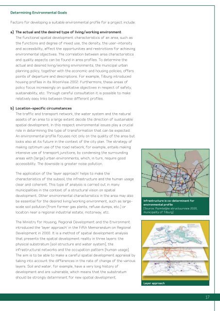
Infr<strong>as</strong>tructure is co-determ<strong>in</strong>ant for<br />
environmental profile<br />
(Source: Ruimtelijke structuurvisie 2020,<br />
municipality of Tilburg)<br />
The M<strong>in</strong>istry for Hous<strong>in</strong>g, Regional Development and the Environment<br />
<strong>in</strong>troduced the ‘layer approach’ <strong>in</strong> the Fifth Memorandum on Regional<br />
Development <strong>in</strong> 2000. It is a method of spatial development analysis<br />
that presents the spatial development reality <strong>in</strong> three layers: the<br />
physical substratum (soil structure and water system), the<br />
<strong>in</strong>fr<strong>as</strong>tructural networks and the occupation pattern (human usage).<br />
The aim is to be able to make a careful spatial development appraisal by<br />
tak<strong>in</strong>g <strong>in</strong>to account the differences <strong>in</strong> the rate of change of the various<br />
layers. Soil and water, for example, have a very long history of<br />
development and are vulnerable, which means that the substratum<br />
should be strongly determ<strong>in</strong>ant for new spatial development.<br />
Layer approach<br />
17