

Landscape – Great Idea! X-LArch III - Department für Raum ...
Landscape – Great Idea! X-LArch III - Department für Raum ...
Landscape – Great Idea! X-LArch III - Department für Raum ...

You also want an ePaper? Increase the reach of your titles
YUMPU automatically turns print PDFs into web optimized ePapers that Google loves.
94<br />
to the site. The public domain is inadequate in serving<br />
a variety of user groups. The HBA is of great aesthetic<br />
value where the original street pattern and vistas are still<br />
preserved. The public spaces in the site, accommodating<br />
two-storey listed buildings with traditional architectural<br />
characteristics particular to Ankara, and monumental<br />
buildings with the architecture of modernisation, have<br />
potentials to provide visual variety and to enhance the<br />
aesthetic quality of the city. Yet, these potentials (thus<br />
the spatial identity) are neglected. Although the site<br />
possesses many historical and cultural layers, much of<br />
these layers are hidden, degraded and lacking a sense<br />
of a unified and legible identity. Finally, the public domain<br />
in the HBA also is not adequately designed, managed<br />
and used in performing its ecological, psychological, and<br />
political functions.<br />
UES ’08 and the general intentions of the student<br />
projects<br />
UES ‘08, organised by METU and the University of Adelaide<br />
as a collaborative exercise in two graduate courses,<br />
and held in Ankara between 30 June and 14 July 2008,<br />
focused on the connection between place and difference.<br />
Its main aims were to raise students’ sensitivity to spatial<br />
and social difference in their experience and design of<br />
constructed environments, and to explore new modes<br />
of design education (UES, 2008). UES ‘08 brought 7<br />
city planning, and 13 architecture students from METU<br />
together with 22 architecture and landscape architecture<br />
students from the University of Adelaide. It focused on<br />
urban matters in the HBA, taking a holistic approach to<br />
dealing with the urban environment that involved design<br />
practices in architecture, landscape architecture, and<br />
urban design (UES, 2008).<br />
Working as international and interdisciplinary teams of 5,<br />
6 and 7, students produced 7 alternative projects with a<br />
number of creative solutions for the problems of the HBA<br />
public domain. Each project team developed a master<br />
plan for the whole project site and detailed design solutions<br />
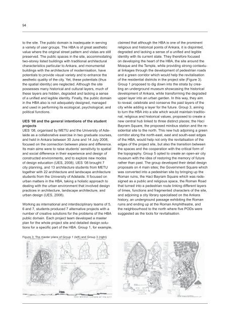
for a specific part of the HBA. Group 1, for example,<br />
claimed that although the HBA is one of the prominent<br />
religious and historical points of Ankara, it is disjointed,<br />
degraded and lacking a sense of a unified and legible<br />
identity with its current state. They therefore focused<br />
on developing the heart of the HBA, the site around the<br />
Mosque and the Temple, while providing strong contextual<br />
linkages through the development of pedestrian roads<br />
and a green corridor which would help the revitalisation<br />
of the residential districts in the project site (Figure 3).<br />
Group 1 proposed to dig down into the strata by creating<br />
an underground museum showcasing the historical<br />
development of Ankara, while transforming the degraded<br />
upper layer into an urban garden. In this way, they aim<br />
to reveal, celebrate and conserve the past layers of the<br />
city while adding a layer for the future. Group 3, aiming<br />
to turn the HBA into a site which would maintain traditional,<br />
religious and historical values, proposed to create a<br />
new central hub linked to three distinct places; the Haci<br />
Bayram Square, the proposed minibus station and the residential<br />
site to the north. This new hub adjoining a green<br />
corridor along the north-east, east and south-east edges<br />
of the HBA, would help not only the revitalisation of the<br />
edges of the project site, but also the transition between<br />
the spaces and the cooperation with the critical form of<br />
the topography. Group 5 opted to create an open-air city<br />
museum with the idea of restoring the memory of future<br />
rather than past. The group developed their detail design<br />
proposals on 4 main sites; the Government Square which<br />
was converted into a pedestrian site by bringing up the<br />
Roman ruins, the Haci Bayram Square which was redesigned<br />
as a public and religious space, the Roman Road<br />
that turned into a pedestrian route linking different layers<br />
of times, functions and fragmented characters of the site,<br />
and adjoining a city library specialised on the Ankara<br />
history, an underground passage exhibiting the Roman<br />
ruins and ending up at the Roman Amphitheatre, and<br />
the neighbourhood to the north where five PODs were<br />
suggested as the tools for revitalisation.<br />
Figure 3: The master plans of Group 1 (left) and Group 3 (right)


