Longnor - land of cheese! Trail Summary - Thedms.co.uk
Longnor - land of cheese! Trail Summary - Thedms.co.uk
Longnor - land of cheese! Trail Summary - Thedms.co.uk

Create successful ePaper yourself
Turn your PDF publications into a flip-book with our unique Google optimized e-Paper software.
How We Ate........<strong>Longnor</strong><br />
Transport<br />
Distance<br />
4.3 km<br />
2.7 mi<br />
Allow<br />
2hr<br />
Diffi culty<br />
<strong>Trail</strong> <strong>Summary</strong><br />
Gentle slopes with some stiles to<br />
climb over and farmyards to pass<br />
through. Occasionally wet underfoot<br />
– boots advisable.<br />
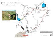
Start and finish:<br />
The Market Place, <strong>Longnor</strong>. Map: Ordnance<br />
Survey map OL 24 White Peak Area SK 088<br />
649.<br />
Access:<br />
By public transport: There 2 or 3 buses<br />
each day between Buxton and <strong>Longnor</strong>.<br />
Buxton is well <strong>co</strong>nnected to other towns<br />
and villages. By car: On the B5053, <strong>of</strong>f the<br />
A515 Buxton to Ashbourne Road. Parking<br />
is available in the market place.<br />
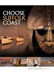
Work up an appetite on this 2.7 mile<br />
circular walk around the glorious Manifold<br />
Valley near to the historic market town <strong>of</strong><br />
<strong>Longnor</strong>. Our walk begins and ends in the<br />
<strong>co</strong>bbled market square. On your way you’ll<br />
dis<strong>co</strong>ver traditional farms, stone barns<br />
and walled fields with herds <strong>of</strong> <strong>co</strong>ws and<br />
flocks <strong>of</strong> sheep. You’ll see <strong>land</strong> that produced<br />
oats and many thousands <strong>of</strong> tons <strong>of</strong><br />
<strong>cheese</strong> each year. On your return, you can<br />
take tea in the Victorian market hall, and<br />
sample delicious local produce.<br />
Part-funded by the European<br />
Union European Regional<br />
Development Fund<br />
<strong>Longnor</strong> - <strong>land</strong> <strong>of</strong> <strong>cheese</strong>!<br />
This map is reproduced from Ordnance Survey material with the permission <strong>of</strong> Controller HMSO. Crown<br />
Copyright. All Rights Reserved. Peak District National Park Authority. License No. LA 100005734. 2005
How We Ate........<strong>Longnor</strong><br />
5,000 tons<br />
Transport<br />
<strong>of</strong> <strong>cheese</strong><br />
The aptly named Glutton Circular Bridge, walk a mile <strong>of</strong> from roughly 4½<br />
<strong>Longnor</strong>, was home to a km <strong>cheese</strong> along factory moderately in the easy<br />
1800s. 5,000 tons <strong>of</strong> <strong>cheese</strong> tracks a year through went downriver<br />
in 1813 Distance – and that doesn’t wood<strong>land</strong> include and all heather<br />
streamside<br />
<strong>cheese</strong> made to be eaten locally! 3 <strong>of</strong> the 4 farms<br />
4 km moor<strong>land</strong>, including some<br />
at nearby Hollinsclough sold all their milk to the<br />
Glutton Bridge 3 <strong>cheese</strong> ascents. Option to add a 2½<br />
miles factory.<br />
km round trip through the<br />
Allow National Trust’s Longshaw<br />
Estate via a tea room and<br />
2hr shop in a former hunting<br />
lodge.<br />
Diffi culty<br />
<strong>Trail</strong> <strong>Summary</strong><br />
Oats are not just for porridge!<br />
These days English people eat lots <strong>of</strong> wheat as<br />
bread, and most only have oats in breakfast cereals<br />
or flapjack. In the past, oats were a staple food.<br />
Our medieval ancestors<br />
farmed oats on the<br />
<strong>land</strong> around<br />
<strong>Longnor</strong> for many generations and this <strong>co</strong>ntinued<br />
all the way into the 1800s. In 1725, the writer Daniel<br />
Defoe noted the region’s food was all ‘oatcakes,<br />
<strong>cheese</strong> and ale’. Traditional Staffordshire and Derbyshire<br />
oatcakes (below left) are similar to taste,<br />
but Derbyshire oatcakes are bigger and thicker<br />
than Staffordshire’s.<br />
1. <strong>Longnor</strong> Market Place<br />
The Victorian market<br />
hall (right) was built in<br />
1873. Look up above<br />
the entrance to see the<br />
original list <strong>of</strong> market<br />
tariffs. The hall is now<br />
a craft centre and<br />
c<strong>of</strong>fee shop. It’s a great<br />
place to try traditional<br />
Staffordshire oatcakes<br />
and local <strong>cheese</strong>s, as<br />
well as lots <strong>of</strong> other<br />
tasty cakes and light<br />
meals. Stilton is the<br />
area’s most famous<br />
<strong>cheese</strong> (top left).<br />
Leave the market place and head left along the<br />
roadside. About 50 metres after the Cheshire<br />
Cheese Pub take the track on your right marked by<br />
a public footpath sign.<br />
2. Folds End Farm<br />
Folds End Farm dates from the 1600s and was extended<br />
in the 1800s. The fields ahead are all sown<br />
with grass as pasture for livestock. The grazing on<br />
the lower <strong>land</strong> is good-quality grass, fit for <strong>co</strong>ws.<br />
These fields once fed the dairy herds whose milk<br />
supplied the local <strong>cheese</strong> trade.<br />
You might see sheep here too. More sheep graze<br />
higher up where only rough grass grows, as<br />
sheep can live on grass that is too poor for <strong>co</strong>ws.<br />
Head left across the yard to the metal gate at the<br />
end <strong>of</strong> the <strong>co</strong>w sheds, leading into fields. Walk<br />
over the field, heading towards the footpath sign.<br />
At the stile the path<br />
splits. Take the route<br />
straight ahead<br />
signed to Brund via<br />
Cr<strong>of</strong>ts Farm and<br />
Boothlow Hayes.<br />
3. The shape <strong>of</strong> a field reveals its age!<br />
From here you have a good view down the<br />
Manifold Valley. You can pick out the line <strong>of</strong> the<br />
River Manifold from the wandering line <strong>of</strong> trees in<br />
the valley bottom. The <strong>land</strong>scape is criss-crossed<br />
with stone walls. The smaller narrow fields are the<br />
remains <strong>of</strong> medieval strip fields. The large square<br />
fields were created in the 1700s and 1800s, as a<br />
result <strong>of</strong> Parliamentary enclosure. At this time<br />
<strong>land</strong>owners passed laws to wall in the Common<br />
One <strong>of</strong> a suite <strong>of</strong> downloadable trails available from www.peak-experience.org.<strong>uk</strong>
How We Ate........<strong>Longnor</strong><br />
Transport<br />
<strong>land</strong>s and keep them private −<br />
<strong>land</strong> where previously Circular everyone<br />
<strong>co</strong>uld graze their animals. km along moderately easy<br />
walk <strong>of</strong> roughly 4½<br />
Look out for some old tracks hawthorn<br />
hedges Distance running wood<strong>land</strong> along and heather<br />
through streamside<br />
earthen banks, and for stone<br />
4 km moor<strong>land</strong>, including some<br />
farmsteads and field barns.<br />
3<br />
ascents. Option to add a 2½<br />
miles<br />
km round trip through the<br />
Keep the wall to your left and walk along until it<br />
Allow<br />
ends. Then carry on straight National across Trust’s the field Longshaw to a<br />
stile.<br />
Estate via a tea room and<br />
2hr shop in a former hunting<br />
4. Crossing the medieval lodge. strip fields<br />
This is the Diffi first culty <strong>of</strong> several stiles taking you<br />
across the strip fields. Medieval farming families<br />
ploughed their fields over the years into ridges<br />
and furrows. Now this <strong>land</strong> is used for animals,<br />
but the ridge and furrow traces reveal that medieval<br />
farmers grew crops here instead, almost<br />
certainly including oats.<br />
<strong>Trail</strong> <strong>Summary</strong><br />
By the 1800s Peak District farmers<br />
grew vast quantities <strong>of</strong> oats. Oats<br />
grew better than wheat on high<br />
ground and because <strong>of</strong> this, they<br />
formed a staple part <strong>of</strong> poor<br />
people’s diets. Try our local oatcakes<br />
to make a tasty <strong>co</strong>nnection<br />
with Staffordshire farming history.<br />
After the last field, the path takes you past a barn<br />
and then passes in front <strong>of</strong> Cr<strong>of</strong>ts Farm and out<br />
into a field. Walk past the farm building on your<br />
left and head to a tree marking the <strong>co</strong>rner <strong>of</strong> a<br />
hedge field boundary. Continue to follow this<br />
boundary hedge, passing over a stile and small<br />
stream, then <strong>co</strong>ntinue with the boundary to your<br />
left. You’ll pass Boothlow Hayes hill up on your left<br />
and a ruined farm building.<br />
5. Improving the <strong>land</strong><br />
Farmers improved the <strong>land</strong> to grow better grass<br />
for <strong>co</strong>ws, by adding lime to fertilize the ground.<br />
Look up to Boothlow Hayes on your left to see<br />
the difference between the rough grazing on the<br />
higher slopes and the improved grazing <strong>land</strong> you<br />
are walking through. The lower fields here are<br />
large and square because they were created in the<br />
1700s or 1800s as part <strong>of</strong> the parliamentary enclosures.<br />
Continue following the boundary through the<br />
next field. In the following field head to the 2-storey<br />
field barn (still in use).<br />
6. Stone field barns<br />
In medieval times, people’s narrow strip fields ran<br />
straight out from the back <strong>of</strong> their house. Farmers<br />
began to build field barns when fields were enclosed<br />
far from the house. Field barns save farmers<br />
time and energy because there’s no need to carry<br />
everything to and from the farmhouse each day.<br />
They use the barns to store equipment and shelter<br />
their animals.<br />
Follow the path from here across the field to<br />
Overbooth Farm, which dates from the early<br />
1800s. The footpath goes through the farmyard<br />
and past the farmhouse. Follow the path diagonally<br />
across the field to a stile in the hedge halfway<br />
down the field.<br />
7. Ridge and furrow, ancient farm traces<br />
Look at the fields rising from the River Manifold<br />
on the right, and you should be able to see lines<br />
<strong>of</strong> ridge and furrow running up hill. Our farming<br />
One <strong>of</strong> a suite <strong>of</strong> downloadable trails available from www.peak-experience.org.<strong>uk</strong>
How We Ate........<strong>Longnor</strong><br />
8. 8. Medieval Transport<br />
ancestors created farm the ridges traces<br />
and furrows as they<br />
ploughed the <strong>land</strong> year Circular after year walk after <strong>of</strong> year. roughly 4½<br />
km along moderately easy<br />
Now you have a choice. tracks You can through move straight streamside on<br />
to point 9 and Distance follow the wood<strong>land</strong> walk back to and <strong>Longnor</strong>, heather<br />
or you can take a detour to point 8 and see some<br />
4 km moor<strong>land</strong>, including some<br />
‘nearly-new’ Belgian Blue <strong>co</strong>ws!<br />
3<br />
ascents. Option to add a 2½<br />
miles<br />
To see the Belgian Blues, km follow round the trip path through the<br />
straight along Allow the hedge National and then Trust’s field walls Longshaw to<br />
Lower Boothlow Farm. Estate via a tea room and<br />
2hr shop in a former hunting<br />
To <strong>co</strong>ntinue without the detour, face towards<br />
lodge.<br />
Over Boothlow Diffi culty Farm and head diagonally across<br />
the field for the bottom left-hand <strong>co</strong>rner. Cross<br />
the field, crossing the farm track linking Over<br />
Boothlow Farm and Waterhouse Farm. There are<br />
the remains <strong>of</strong> old wooden stiles either side <strong>of</strong><br />
the track. Continue following the line <strong>of</strong> the river<br />
through the next stile.<br />
<strong>Trail</strong> <strong>Summary</strong><br />
8. The Belgian Blues<br />
Lower Boothlow Farm dates from<br />
the early 1800s, but its Belgian<br />
Blue <strong>co</strong>ws are much more recent<br />
imports to Britain. The first<br />
Belgian Blues were bred in the<br />
1960s. They were imported to Britain in the 1980s<br />
and are prized for producing huge amounts <strong>of</strong><br />
beef on each <strong>co</strong>w.<br />
Now head back the way you came to point 7 and<br />
<strong>co</strong>ntinue from there to point 9.<br />
9. The Manifold River<br />
The river now runs a much straighter line than it<br />
used to. Ancient parish re<strong>co</strong>rds and modern aerial<br />
photographs show a far more winding path.<br />
The path <strong>co</strong>ntinues near the river through the<br />
next five fields, with the stiles near the Cr<strong>of</strong>ts<br />
Farm painted white.<br />
At the se<strong>co</strong>nd field boundary you cross, you’ll see<br />
a brook. This used to mark an old parish boundary<br />
between Sheen and <strong>Longnor</strong>. The next two<br />
walls you cross link upslope with the lines <strong>of</strong> the<br />
narrow strip fields you crossed earlier, showing<br />
that some <strong>of</strong> the medieval strips <strong>co</strong>ntinued down<br />
to the river.<br />
10. Back to the market place<br />
At the next stile head diagonally across the field<br />
back up to Folds End Farm. From the farm, walk<br />
back up the track to the market place.<br />
You’ll find some very wel<strong>co</strong>me refreshments to<br />
enjoy and local arts and crafts to browse in the<br />
old market hall. Don’t forget to try some local<br />
<strong>cheese</strong>s and oatcakes!<br />
We hope you enjoyed your walk. Please tell your<br />
friends. There are more Peak Experience selfguided<br />
trails for you to download at<br />
www.peak-experience.org.<strong>uk</strong><br />
Inspired by the <strong>land</strong>scape?<br />
Send us photos or stories from your walk to share<br />
with others on www.MyPeakExperience.org.<strong>uk</strong><br />
And if you or your children were inspired to<br />
create poetry, songs, paintings or drawings we’d<br />
love to see them.<br />
And finally...<br />
More <strong>cheese</strong>! If you’re interested in finding out<br />
more about local <strong>cheese</strong> production, we re<strong>co</strong>mmend<br />
this very informative online article: http://<br />
www.aboutderbyshire.<strong>co</strong>.<strong>uk</strong>/cms/9/hartingtonthe-kings-stil-2.shtml<br />
Written by: Melissa Peet & Bill Bevan, ed by G Lither<strong>land</strong>.<br />
Photos by: Georgia Lither<strong>land</strong>, Ray Manley (PDNPA).<br />
One <strong>of</strong> a suite <strong>of</strong> downloadable trails available from www.peak-experience.org.<strong>uk</strong>