Fields & Farms North of Eldwick - Bradford Metropolitan District ...
Fields & Farms North of Eldwick - Bradford Metropolitan District ...
Fields & Farms North of Eldwick - Bradford Metropolitan District ...

You also want an ePaper? Increase the reach of your titles
YUMPU automatically turns print PDFs into web optimized ePapers that Google loves.
City <strong>of</strong> <strong>Bradford</strong> <strong>Metropolitan</strong> <strong>District</strong> Council<br />
Countryside & Rights <strong>of</strong> Way<br />
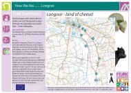
<strong>Fields</strong> & <strong>Farms</strong> <strong>North</strong><br />
<strong>of</strong> <strong>Eldwick</strong> (Heathers Choice)<br />
3 1 /2 miles (5.6km) Circular walk<br />
This walk was suggested by<br />
Heather, the Group Support<br />
Officer for the Countryside &<br />
Rights <strong>of</strong> Way Service<br />
Walk Start Point<br />
The footpath between <strong>Eldwick</strong> Memorial Hall and St<br />
Lawrence's Church, <strong>of</strong>f Otley Road, <strong>Eldwick</strong>.<br />
Car Parking<br />
There are no public car parks nearby; therefore, parking<br />
is on street. Please park with care and consideration.<br />
Do not park in the Memorial Hall car park unless you<br />
have prior permission.<br />
Public Transport<br />
Monday-Saturday a regular bus service 622/623 operates<br />
from <strong>Bradford</strong>. Evenings and weekend service 615/616<br />
operates from <strong>Bradford</strong>. All services are via Bingley<br />
railway station. For details contact Metroline on:<br />
0113 245 7676<br />
The Route<br />
Quite an easy walk with no steep hills, walking mainly<br />
on farmland footpaths to the north <strong>of</strong> <strong>Eldwick</strong>. You will<br />
require strong footwear and outdoor clothing to suit the<br />
season. A light snack with a drink is also recommended.<br />
This walk is not suitable for wheelchairs, pushchairs and<br />
people with limited mobility.<br />
The Walk<br />
Cross the Memorial Hall car park, walking between the<br />
tennis courts and the wooden building in the church<br />
grounds, out onto the recreation ground. Here turn<br />
immediately right, following the dry stone wall on the<br />
right for a short distance, before climbing over a stile in<br />
the wall corner into a field.<br />
Cross the field diagonally to the left, heading for the two<br />
gate stoops, which can be seen ahead. Pass between<br />
the two gate stoops and continue straight ahead across<br />
the next field and down a slight incline to climb over the<br />
stile in the stone wall, out onto a narrow road (The<br />
Green). Turn left up the road, following it as it changes<br />
to an unsurfaced track, continuing as it changes back<br />
to a surfaced road. Where the road turns sharp right<br />
and is joined by a rough track joining from the left, turn<br />
left up the rough track (Tewitt Lane). On reaching the<br />
top <strong>of</strong> the incline continue straight ahead for a further<br />
100yds (91m), before turning right, to walk between the<br />
gate stoops following the bridleway along the wide walled<br />
track, as it undulates towards the reservoir embankment.<br />
Cross the stepping-stones <strong>of</strong> the reservoir overflow and<br />
continue to follow the track through a gate and uphill to<br />
the top corner <strong>of</strong> the reservoir embankment. On reaching<br />
the top corner bear slightly to the right to follow the<br />
obvious rough track uphill, which will eventually bring<br />
you out onto the busy Otley Road. Here, cross over<br />
the road and turn left to walk uphill facing the oncoming<br />
traffic for approximately 200yds (182m). Turn right along<br />
the surfaced access road towards Toils Farm, on<br />
reaching the farm buildings (beware <strong>of</strong> the dogs), bear<br />
left between the farm and the barn and climb over the<br />
stile, which can be seen ahead. Cross the field by<br />
walking parallel to the rear <strong>of</strong> the farmhouse on your<br />
right and climb a second stile into a small wooded area,<br />
before climbing a third stile over a stone wall into a<br />
much larger field.<br />
Continue by walking straight ahead, following the dry<br />
stone wall on your right, trying to avoid the very wet<br />
boggy area, half-way across the field, eventually reaching<br />
a stile. Climb over the stile onto a surfaced road. Turn<br />
left here, up the surfaced road to its junction at the top<br />
with Otley Road, near the buildings <strong>of</strong> Whitecr<strong>of</strong>t Farm.<br />
Turn right along the busy Otley Road to walk behind<br />
the farm buildings <strong>of</strong> White Cr<strong>of</strong>t Farm, facing the<br />
oncoming traffic for approximately 200yds (182m), before<br />
turning right <strong>of</strong>f the road and across the wide grassy<br />
verge, to climb a stile into a field. Once in the field walk<br />
straight ahead, immediately crossing a broken down<br />
wall, and continue down a slight incline and across a<br />
s<strong>of</strong>t racehorse track, heading for a large pile <strong>of</strong> discarded<br />
walling stone, which can be seen ahead, crossing a<br />
second horseracing track along the way. On reaching<br />
the pile <strong>of</strong> stones walk on, keeping the stones on your<br />
right, passing a second smaller pile <strong>of</strong> stones. From<br />
here continue in a straight line, following a strip <strong>of</strong> rough<br />
grass on the right, eventually turning right, following the<br />
rough grass down to a dry stone wall. On reaching the<br />
wall turn left and follow the line <strong>of</strong> the wall, eventually<br />
turning right at the first corner, follow the wall a short<br />
distance further to a gateway in the wall on your right.<br />
Turn sharp left here, to walk the short distance across<br />
the field to the gate, which can be seen, opposite. Go