Fields & Farms North of Eldwick - Bradford Metropolitan District ...
Fields & Farms North of Eldwick - Bradford Metropolitan District ...
Fields & Farms North of Eldwick - Bradford Metropolitan District ...

Create successful ePaper yourself
Turn your PDF publications into a flip-book with our unique Google optimized e-Paper software.
<strong>Eldwick</strong> Beck<br />
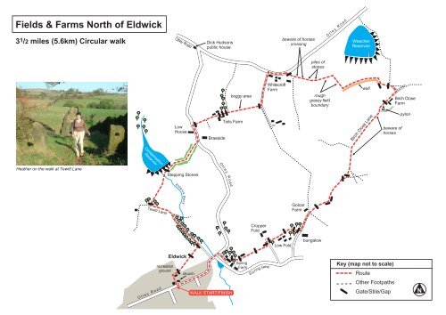
<strong>Fields</strong> & <strong>Farms</strong> <strong>North</strong> <strong>of</strong> <strong>Eldwick</strong><br />
3 1 /2 miles (5.6km) Circular walk<br />
Otley Road<br />
Dick Hudsons<br />
public house<br />
beware <strong>of</strong> horses<br />
crossing<br />
Otley Road<br />
Weecher<br />
Reservoir<br />
piles <strong>of</strong><br />
stones<br />
boggy area<br />
Whitecr<strong>of</strong>t<br />
Farm<br />
rough<br />
grassy field<br />
boundary<br />
wall<br />
Birch Close<br />
Farm<br />
Low<br />
House<br />
Braeside<br />
Toils Farm<br />
Birch Close Lane<br />
beware <strong>of</strong><br />
horses<br />
pylon<br />
Compensation<br />
Reservoir<br />
Otley Road<br />
Heather on the walk at Tewitt Lane<br />
Stepping Stones<br />
Tewitt Lane<br />
Golcar<br />
Farm<br />
Cropper<br />
Fold<br />
Low Fold<br />
bungalow<br />
recreation<br />
ground<br />
<strong>Eldwick</strong><br />
church<br />
Spring<br />
Farm<br />
Spring Lane<br />
Key (map not to scale)<br />
Route<br />
Otley Road<br />
WALK START/FINISH<br />
Other Footpaths<br />
Gate/Stile/Gap<br />
N
City <strong>of</strong> <strong>Bradford</strong> <strong>Metropolitan</strong> <strong>District</strong> Council<br />
Countryside & Rights <strong>of</strong> Way<br />
<strong>Fields</strong> & <strong>Farms</strong> <strong>North</strong><br />
<strong>of</strong> <strong>Eldwick</strong> (Heathers Choice)<br />
3 1 /2 miles (5.6km) Circular walk<br />
This walk was suggested by<br />
Heather, the Group Support<br />
Officer for the Countryside &<br />
Rights <strong>of</strong> Way Service<br />
Walk Start Point<br />
The footpath between <strong>Eldwick</strong> Memorial Hall and St<br />
Lawrence's Church, <strong>of</strong>f Otley Road, <strong>Eldwick</strong>.<br />
Car Parking<br />
There are no public car parks nearby; therefore, parking<br />
is on street. Please park with care and consideration.<br />
Do not park in the Memorial Hall car park unless you<br />
have prior permission.<br />
Public Transport<br />
Monday-Saturday a regular bus service 622/623 operates<br />
from <strong>Bradford</strong>. Evenings and weekend service 615/616<br />
operates from <strong>Bradford</strong>. All services are via Bingley<br />
railway station. For details contact Metroline on:<br />
0113 245 7676<br />
The Route<br />
Quite an easy walk with no steep hills, walking mainly<br />
on farmland footpaths to the north <strong>of</strong> <strong>Eldwick</strong>. You will<br />
require strong footwear and outdoor clothing to suit the<br />
season. A light snack with a drink is also recommended.<br />
This walk is not suitable for wheelchairs, pushchairs and<br />
people with limited mobility.<br />
The Walk<br />
Cross the Memorial Hall car park, walking between the<br />
tennis courts and the wooden building in the church<br />
grounds, out onto the recreation ground. Here turn<br />
immediately right, following the dry stone wall on the<br />
right for a short distance, before climbing over a stile in<br />
the wall corner into a field.<br />
Cross the field diagonally to the left, heading for the two<br />
gate stoops, which can be seen ahead. Pass between<br />
the two gate stoops and continue straight ahead across<br />
the next field and down a slight incline to climb over the<br />
stile in the stone wall, out onto a narrow road (The<br />
Green). Turn left up the road, following it as it changes<br />
to an unsurfaced track, continuing as it changes back<br />
to a surfaced road. Where the road turns sharp right<br />
and is joined by a rough track joining from the left, turn<br />
left up the rough track (Tewitt Lane). On reaching the<br />
top <strong>of</strong> the incline continue straight ahead for a further<br />
100yds (91m), before turning right, to walk between the<br />
gate stoops following the bridleway along the wide walled<br />
track, as it undulates towards the reservoir embankment.<br />
Cross the stepping-stones <strong>of</strong> the reservoir overflow and<br />
continue to follow the track through a gate and uphill to<br />
the top corner <strong>of</strong> the reservoir embankment. On reaching<br />
the top corner bear slightly to the right to follow the<br />
obvious rough track uphill, which will eventually bring<br />
you out onto the busy Otley Road. Here, cross over<br />
the road and turn left to walk uphill facing the oncoming<br />
traffic for approximately 200yds (182m). Turn right along<br />
the surfaced access road towards Toils Farm, on<br />
reaching the farm buildings (beware <strong>of</strong> the dogs), bear<br />
left between the farm and the barn and climb over the<br />
stile, which can be seen ahead. Cross the field by<br />
walking parallel to the rear <strong>of</strong> the farmhouse on your<br />
right and climb a second stile into a small wooded area,<br />
before climbing a third stile over a stone wall into a<br />
much larger field.<br />
Continue by walking straight ahead, following the dry<br />
stone wall on your right, trying to avoid the very wet<br />
boggy area, half-way across the field, eventually reaching<br />
a stile. Climb over the stile onto a surfaced road. Turn<br />
left here, up the surfaced road to its junction at the top<br />
with Otley Road, near the buildings <strong>of</strong> Whitecr<strong>of</strong>t Farm.<br />
Turn right along the busy Otley Road to walk behind<br />
the farm buildings <strong>of</strong> White Cr<strong>of</strong>t Farm, facing the<br />
oncoming traffic for approximately 200yds (182m), before<br />
turning right <strong>of</strong>f the road and across the wide grassy<br />
verge, to climb a stile into a field. Once in the field walk<br />
straight ahead, immediately crossing a broken down<br />
wall, and continue down a slight incline and across a<br />
s<strong>of</strong>t racehorse track, heading for a large pile <strong>of</strong> discarded<br />
walling stone, which can be seen ahead, crossing a<br />
second horseracing track along the way. On reaching<br />
the pile <strong>of</strong> stones walk on, keeping the stones on your<br />
right, passing a second smaller pile <strong>of</strong> stones. From<br />
here continue in a straight line, following a strip <strong>of</strong> rough<br />
grass on the right, eventually turning right, following the<br />
rough grass down to a dry stone wall. On reaching the<br />
wall turn left and follow the line <strong>of</strong> the wall, eventually<br />
turning right at the first corner, follow the wall a short<br />
distance further to a gateway in the wall on your right.<br />
Turn sharp left here, to walk the short distance across<br />
the field to the gate, which can be seen, opposite. Go
through the gate and along a short section <strong>of</strong> grassy<br />
track out onto a surfaced lane and turn right, to walk<br />
down to the T-junction with Birch Close Lane. Turn right<br />
to follow the lane, walking to the rear <strong>of</strong> Birch Close<br />
Farm buildings. At the far end <strong>of</strong> the buildings continue<br />
straight ahead through the gateway, to follow Birch Close<br />
Lane as it bears slightly to the left, changing from a<br />
rough grassy track onto a s<strong>of</strong>t, surfaced horseracing<br />
track. Here, continue straight ahead past the electricity<br />
pylon on your left and another track, which joins from<br />
the left, to follow the wide surfaced horseracing track<br />
(Birch Close Lane), for quite a distance. Where the<br />
track bears slightly to the left continue to follow the s<strong>of</strong>t<br />
surfaced track straight ahead, ignoring all <strong>of</strong> the paths,<br />
which cross from, left to right and continue on down to<br />
the metal field gate, which can be seen ahead.<br />
On reaching the metal gate, go through turning<br />
immediately right <strong>of</strong>f the wide track, to walk through the<br />
rough grass, following the dry stone wall on your right,<br />
as it bears left to a stile gate on your right. Turn right<br />
to go through or over the stile into the field, walk straight<br />
ahead here, following the worn grassy path parallel to<br />
the broken down fence on your left, to eventually reach<br />
the two field gateways at the far end <strong>of</strong> the field. Here<br />
ignore the two gates and turn sharp right, walking with<br />
the broken down stone wall and rough post and wire<br />
fence on your left, following the worn grassy path as it<br />
eventually bears to the left to a gate and stile.<br />
Turn right and walk along the narrow road to its junction<br />
with the main Otley Road, here turn left downhill at first,<br />
before following Otley Road uphill back to your walk<br />
start point.<br />
Footnote<br />
We hope you enjoyed your walk. If so tell your friends,<br />
if not, or you have encountered any problems please<br />
tell us at:<br />
City <strong>of</strong> <strong>Bradford</strong> <strong>Metropolitan</strong> <strong>District</strong> Council<br />
Transportation, Design & Planning<br />
The Countryside & Rights <strong>of</strong> Way Service<br />
5th Floor, Jacobs Well, <strong>Bradford</strong> BD1 5RW<br />
Tel: 01274 432666<br />
www.bradford.gov.uk<br />
e-mail: danny.jackson@bradford.gov.uk<br />
Climb the stile to follow the rough grassy track straight<br />
ahead to where it changes to a rough surfaced lane as<br />
you pass Golcar Farm on your right. After approximately<br />
200yds (182m) along the lane and just before the<br />
bungalow, which can be seen on your left, turn right <strong>of</strong>f<br />
the lane and across the grass verge to a stone stile,<br />
hidden under the trees. Climb over the stile and then<br />
almost straight away over a second stile into the field.<br />
The footpath then follows the dry stone wall on your left<br />
as it bears to the left, to a broken down stile in the wall<br />
corner adjacent to the farm buildings on your left. Climb<br />
the stile into the next field to follow the old wire fence<br />
and the line <strong>of</strong> trees on your left, to eventually climb<br />
another stile at the far end <strong>of</strong> the field out onto a rough<br />
access track. Here, cross over the track and walk a few<br />
yards straight ahead across the grass verge to turn left<br />
through the stile in the dry stone wall on your left.<br />
Once through, turn sharp right and follow the wall, now<br />
on your right straight ahead, passing between a wide<br />
gap in the dry stone wall, which crosses your path at<br />
right angles, to continue straight ahead over a second<br />
field, still keeping the wall on your right. At the far end<br />
<strong>of</strong> the field, where the wall bears to the right, ignore the<br />
wide gap, which leads <strong>of</strong>f to the right, and continue<br />
straight ahead through the narrower gap and over the<br />
stile into a small field. Once over the stile turn right to<br />
follow the wall on your right for the short distance across<br />
the field to a small gate.<br />
Through the gate the path divides, our route is to the<br />
left following the broken down wall and the post and<br />
wire fence on the left, downhill to eventually walk<br />
underneath a line <strong>of</strong> trees on your left, parallel to the<br />
house drive and through a gap out onto a narrow road.