Create successful ePaper yourself
Turn your PDF publications into a flip-book with our unique Google optimized e-Paper software.
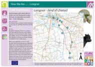
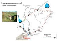
cow & calf rocks<br />
via white wells<br />
10<br />
walk 03<br />
3 Miles (4.8km)<br />
Allow 2 hours 30 mins<br />
visitilkley.com<br />
11<br />
MAP KEY:<br />
Main Route<br />
Other Paths<br />
Road<br />
Building<br />
Bridge<br />
Stream<br />
Pool<br />
Moorland<br />
P Car Park<br />
S<br />
E<br />
?<br />
W<br />
North<br />
0 metres 25<br />
?<br />
<strong>ILKLEY</strong> MOOR<br />
White<br />
Wells<br />
Steps<br />
Ilkley<br />
Crags<br />
Large<br />
Boulder<br />
Quaries<br />
(disused)<br />
Rocky<br />
Valley<br />
P<br />
Hotel<br />
Willy Hall’s<br />
Spout<br />
Upper<br />
Tarn<br />
Ilkley<br />
Tarn<br />
Rocks<br />
Quaries<br />
(disused)<br />
Cow and<br />
Calf Rocks<br />
Waterworks<br />
Building<br />
Steps<br />
P<br />
Paddling<br />
Pool<br />
Shelter<br />
Steps<br />
Stone<br />
Wells<br />
House<br />
Darwin<br />
Gardens<br />
P<br />
CROSSBECK ROAD<br />
Gate and<br />
Catte Grid<br />
WELLS ROAD<br />
Tourist<br />
Information<br />
Apartments Centre<br />
COWPASTURE ROAD<br />
01<br />
to Town<br />
Centre<br />
Rail & Bus<br />
Station<br />
01 Cow & Calf Rocks.<br />
This walk involves steep<br />
uphill walking over rough<br />
moorland paths, therefore<br />
it is not suitable for the<br />
less mobile and pushchairs.<br />
Sensible footwear and a<br />
wind and waterproof coat<br />
recommended along with<br />
a light snack and drink.<br />
With the information centre<br />
behind you turn left<br />
towards the town centre.<br />
After approximately 200<br />
yards turn left up Wells<br />
Road. Continue uphill for<br />
quite some distance to the<br />
junction with Crossbeck<br />
Road. Here cross over<br />
Crossbeck Road diagonally<br />
to the left onto a small car<br />
parking area at the side of<br />
an apartment block.<br />
Walk across the parking<br />
area to the two gates<br />
ahead. Go through the<br />
small gate on the right and<br />
up the steps, between the<br />
paddling pool on the right<br />
and the shelter to the left,<br />
to follow the path steeply<br />
uphill to White Wells Bath<br />
House high on the moor<br />
(White Wells is open to<br />
view the Plunge Pool and<br />
for refreshments when the<br />
flags are flying). Continue<br />
uphill via the steps to the<br />
left and rear of the building<br />
to join a wider path behind<br />
the small group of trees<br />
above. Turn left following<br />
this wider path uphill<br />
further onto the moor.<br />
Eventually the path divides,<br />
ignore the path up the<br />
steps to the right and<br />
continue along the path to<br />
the left leading to Rocky<br />
Valley keeping Ilkley Crags<br />
high on your right.<br />
At the end of Rocky Valley<br />
the path divides again.<br />
Our route is downhill to<br />
the left, where straight<br />
ahead in the middle<br />
distance, the top outline<br />
of the “Cow” rock can be<br />
seen. Continue along this<br />
path as it descends down<br />
to Backstone Beck, cross<br />
over the beck to follow the<br />
path straightforward<br />
passing on your right a<br />
single large boulder.<br />
Further down where the<br />
path levels out another<br />
path crosses from left to<br />
right, (remember this<br />
junction as you will pass it<br />
again on your return walk).<br />
Walk straight forward to<br />
your destination the<br />
Cow & Calf Rocks.<br />
Please take great care<br />
whilst walking amongst<br />
the rocks and along the<br />
edge of the quarry. Please<br />
ensure that children are<br />
supervised at all times.<br />
To return, retrace your<br />
steps to where the footpaths<br />
crossed on the moorland<br />
behind the “Cow” rock to<br />
take the path to the right<br />
along the side of the<br />
former quarry. At the far<br />
end of the quarry the path<br />
divides. Take the grassy<br />
path straight forward<br />
downhill to a second<br />
junction, again continue<br />
straight forward downhill<br />
where after a short<br />
distance several other<br />
paths have been made<br />
down this very steep<br />
hillside. Here the choice is<br />
yours as the paths make<br />
their way down to the<br />
small footbridge below.<br />
Cross the footbridge to<br />
follow the footpath straight<br />
forward. After<br />
approximately 150 yards<br />
the path divides again,<br />
follow the footpath straight<br />
forward downhill between<br />
the small tree on the left<br />
and the large stone on the<br />
right to eventually emerge<br />
onto the surfaced path at<br />
the lower tarn.<br />
Walk round either side<br />
of the tarn to the far end<br />
to follow the surfaced<br />
path downhill, through<br />
the gate, cross over<br />
Crossbeck Road turning<br />
right down Wells Road<br />
back to your starting point.