Create successful ePaper yourself
Turn your PDF publications into a flip-book with our unique Google optimized e-Paper software.
outdoor enjoyment,<br />
walkers’ heaven<br />
& breathtaking<br />
landscapes<br />
02<br />
A bright<br />
canvas<br />
visitbradford.com<br />
Bradford is an internationally<br />
important centre for fine<br />
art, attracting artists and<br />
exhibitions from all over<br />
the world.<br />
You can take your pick from<br />
an impressive collection<br />
of galleries, such as the<br />
Impressions Gallery. One of<br />
the UK’s most celebrated<br />
photography venues; it<br />
champions the best of<br />
today’s emerging talent.<br />
You’ll also find the Bradford<br />
1 Gallery showcasing<br />
contemporary and historic<br />
art and craft from national<br />
touring galleries.<br />
Then there’s the<br />
Cartwright Hall Art Gallery<br />
with its major exhibitions<br />
of contemporary art and<br />
stunning works by Lowry,<br />
Reynolds and Warhol.<br />
One of the world’s largest<br />
collections of David<br />
Hockney works is on<br />
display at Salts Mill. Get<br />
your timing right, and you<br />
can also enjoy the Saltaire<br />
Arts Trail, a vibrant festival<br />
of art packed full of unique<br />
art and textile shows.<br />
And for an eclectic and<br />
compelling programme<br />
of International art<br />
exhibitions, make a<br />
bee-line for Bradford<br />
University’s Gallery II.<br />
ilkley<br />
walking <strong>guide</strong>
welcome to the<br />
ilkley wAlkers Are<br />
welcome walking <strong>guide</strong><br />
02<br />
contents visitilkley.com<br />
03<br />
03 Welcome<br />
04 Walkers are Welcome<br />
06 Darwin Walk (1 mile)<br />
08 Ilkley’s Town Centre<br />
Blue Plaque Walk<br />
(1.5 miles)<br />
10 Cow & Calf Rocks via<br />
White Wells (3 miles)<br />
12 Mount Calvary<br />
& Middleton<br />
Woods (3 miles)<br />
14 The Swastika Stone<br />
& Hebers Ghyll<br />
(3.5 miles)<br />
16 Nestfield &<br />
Upper Austby<br />
(6.5 miles)<br />
18 Length & Breadth of<br />
Ilkley Moor (7 miles)<br />
20 Ilkley to Addingham<br />
& Back (8 miles)<br />
22 Long Distance Walks/<br />
Guided Walks/<br />
Points of Interest<br />
24 Ilkley<br />
26 Getting Here/<br />
Accommodation<br />
Information<br />
27 Map of Ilkley<br />
Ilkley is a former spa town<br />
set in the magnificent<br />
Yorkshire Dales. Surrounded<br />
by beautiful countryside,<br />
Ilkley offers endless<br />
opportunities to enjoy the<br />
great outdoors.<br />
Ilkley has recently been<br />
accredited Walkers are<br />
Welcome status due to its<br />
fantastic countryside,<br />
walks for all abilities and<br />
its commitment to<br />
welcoming walkers. Our<br />
<strong>guide</strong> gives you more<br />
information on the Walkers<br />
are Welcome scheme as<br />
well as more information<br />
on why Ilkley is a Walkers<br />
are Welcome destination.<br />
Our <strong>guide</strong> also details a<br />
variety of self-<strong>guide</strong>d<br />
walks of different gradings,<br />
from a heritage walk<br />
around the town to a 7 mile<br />
walk along the length and<br />
breadth of Ilkley Moor.<br />
We hope our <strong>guide</strong> inspires<br />
you to visit Ilkley and<br />
provides you with the right<br />
information to enjoy<br />
walking in this popular and<br />
beautiful part of Yorkshire.<br />
Ilkley & Wharfedale<br />
Tourism Partnership.
walkers are<br />
welcome<br />
04<br />
05<br />
visitilkley.com<br />
What is Walkers are<br />
Welcome (WaW)?<br />
WaW is a community<br />
led initiative to promote<br />
towns as places that have<br />
something special to<br />
offer walkers of all kinds.<br />
Towns and villages who<br />
seek Walkers are Welcome<br />
must fulfil six criteria to<br />
gain accreditation:<br />
• Demonstrate local<br />
support for the concept<br />
• Gain formal endorsement<br />
for the application<br />
• Ensure that footpaths<br />
and facilities for walkers<br />
are well maintained<br />
• Market the WaW scheme<br />
• Encourage walking via<br />
public transport<br />
• Demonstrate how WaW<br />
status will be maintained.<br />
Why is Ilkley a Walkers<br />
are Welcome destination?<br />
Walks for all abilities<br />
Ilkley has walking routes<br />
for all abilities. If you fancy<br />
a short walk, there are lots<br />
of pleasant strolls onto<br />
Ilkley Moor or around<br />
Middleton Woods and the<br />
River Wharfe. For a more<br />
vigorous walk why not walk<br />
to Addingham and back or<br />
admire the views while<br />
walking the length and<br />
breadth of Ilkley Moor.<br />
Browse our <strong>guide</strong>; we’re<br />
sure you’ll find a walk<br />
to suit you.<br />
Pathways that are kept<br />
well maintained<br />
Bradford Council’s<br />
Countryside and Rights of<br />
Way Service (CROW)<br />
protects and maintains<br />
recorded public footpaths<br />
and bridleways. The<br />
Service carries out planned<br />
annual maintenance,<br />
vegetation clearance and<br />
signposting, responds to<br />
reported new issues of<br />
obstruction, encroachment,<br />
or surface deterioration,<br />
and works with landowners<br />
to maintain and replace<br />
stiles and gates.<br />
Dales Way<br />
If you enjoy long distance<br />
trails try the Dales Way<br />
which officially starts in<br />
Ilkley. This 80 mile walk to<br />
Bowness-on-Windermere<br />
takes in the stunning<br />
countryside of Wharfedale<br />
and beyond and is a<br />
popular route for walkers<br />
of all abilities.<br />
Interesting history<br />
Ilkley has a long and<br />
interesting history that<br />
can be discovered while<br />
walking one of the routes<br />
in this <strong>guide</strong>. Ilkley Moor<br />
boasts several prehistoric<br />
rock carvings, the most<br />
famous of which are the<br />
Cup and Ring stones<br />
and the Swastika stone.<br />
There is also the huge<br />
embellished Badger Stone<br />
and the Twelve Apostles<br />
stone circle. All of them<br />
present unanswered<br />
mysteries about the<br />
ancient history of man<br />
on Ilkley Moor.<br />
01 Ilkley Moor.<br />
02 White Wells Spa Cottage.<br />
Beautiful countryside<br />
Wharfedale is one of<br />
Yorkshire’s most attractive<br />
dales and offers impressive<br />
views in any season.<br />
Middleton Woods is awash<br />
with bluebells in May and<br />
unrivalled views of the<br />
Yorkshire Dales and<br />
beyond can be enjoyed<br />
from Ilkley Moor.<br />
Excellent walking<br />
friendly accommodation<br />
There’s an abundance of<br />
quality hotels, guest<br />
accommodation and self<br />
catering accommodation<br />
in Ilkley. Several properties<br />
in the area have been<br />
inspected under Quality<br />
in Tourism’s Walkers are<br />
Welcome accommodation<br />
inspection scheme.<br />
Properties that have the<br />
accreditation offer facilities<br />
and services for walkers<br />
such as drying rooms and<br />
packed lunches.<br />
Good choice of walker<br />
friendly pubs and<br />
restaurants<br />
Ilkley has lots of<br />
walker friendly pubs<br />
and restaurants who<br />
welcome walking boots<br />
and sometimes dogs.<br />
Try Bar T’at which has<br />
lots of real ales as well as<br />
good food (walking boots<br />
welcome) or the Cow and<br />
Calf on Ilkley Moor.<br />
Lots of information<br />
Ilkley and the surrounding<br />
district offer endless<br />
opportunities to enjoy<br />
walking. Visit visitilkley.<br />
com for more walks or<br />
visitbradford.com for<br />
walks in the Bradford<br />
district. Ilkley Tourist<br />
Information Centre also<br />
sells lots of different<br />
walking <strong>guide</strong>s and maps.<br />
01 02
Darwin<br />
Walk<br />
06<br />
walk 01<br />
1 Mile (1.6km)<br />
Allow 1 hour<br />
visitilkley.com<br />
07<br />
MAP KEY:<br />
Main Route<br />
Alternative<br />
Other Paths<br />
Road<br />
Building<br />
Bridge<br />
Stream<br />
Pool<br />
to White Wells<br />
to White Wells<br />
WELLS ROAD<br />
5<br />
2<br />
1<br />
Car Park<br />
3<br />
4<br />
WELLS HOUSE<br />
1. The walk starts from the<br />
main signboard at the far<br />
end of Darwin Gardens car<br />
park. Follow the boulder<br />
wall around to the plaque<br />
of Charles Darwin, beside<br />
a boulder of local sandstone<br />
known as Millstone Grit.<br />
Fossils contained in rocks<br />
formed an essential part of<br />
the evidence for Darwin’s<br />
theory of evolution.<br />
2. Past the monument,<br />
turn right on a tarmac path<br />
which passes the<br />
Millennium Maze then<br />
bends left to follow a<br />
hedgerow. When the path<br />
forks, take the right fork<br />
to cross a bridge, then a<br />
left fork on a sand path<br />
heading uphill to reach a<br />
boulder bearing an Ilkley<br />
Civic Society blue plaque<br />
for Wells House.<br />
3. Beyond the monument<br />
turn right through a<br />
gateway and follow the<br />
drive left to the impressive<br />
entrance of Wells House,<br />
the hydro where Charles<br />
Darwin stayed whilst<br />
taking the ‘water cure’.<br />
4. Return past the blue<br />
plaque monument and<br />
continue ahead along the<br />
sand path. This winds<br />
left downhill to pass a<br />
pond and willow arbour,<br />
then right to pass the‚<br />
‘Millennial Vision’ viewpoint,<br />
and reaches the pavement<br />
alongside Wells Road.<br />
Charles Darwin often<br />
walked a similar sand<br />
path at Down House,<br />
his home in Kent.<br />
5. White Wells bathhouse<br />
is easily seen on the<br />
hillside above, and can be<br />
reached by a moorland<br />
track from the other side of<br />
Wells Road. However the<br />
main walk turns left to<br />
follow a tarmac path<br />
beside a hedgerow, then<br />
right on a grass path<br />
round the maze, returning<br />
downhill to the ‘Darwin’s<br />
View’ monument. Cross the<br />
car park, turn right to the<br />
pavement, and left through<br />
a gate, then cross Wells<br />
Road and follow pavement<br />
beside Crossbeck Road to<br />
reach the elegant front of<br />
Hillside (formerly North<br />
View House), part of which<br />
was occupied by Charles<br />
Darwin and his family<br />
during his stay in Ilkley.<br />
6. From here, a moorland<br />
track climbs to White<br />
Wells. The town centre<br />
can be reached using<br />
paths through Darwin<br />
Gardens and Mill Ghyll,<br />
or via Wells Road.<br />
0 metres 25<br />
HILLSIDE COURT<br />
(formerly North<br />
View House)<br />
S<br />
E<br />
6<br />
CROSSBECK ROAD<br />
W<br />
North<br />
to Town Centre<br />
01 Darwin Gardens.<br />
02 Darwin Gardens.<br />
01<br />
02
lue plaques<br />
walk<br />
08<br />
09<br />
walk 02<br />
1.5 Miles (2.4km)<br />
Allow Approx 1 hour<br />
visitilkley.com<br />
01 Blue Plaque.<br />
02 Manor House.<br />
Learn more about Ilkley’s<br />
history and its historic<br />
buildings on this Blue<br />
Plaques walk. This circular,<br />
self-<strong>guide</strong>d town centre<br />
walk takes approximately<br />
one hour.<br />
Start the walk at Ilkley<br />
Town Hall (Station Road).<br />
Plaque 1 can be seen to<br />
the right of the entrance.<br />
Walk towards the town<br />
centre along Station Road<br />
crossing Wells Road and<br />
Wells Promenade, to the<br />
circular flowerbed. Take<br />
the left path through the<br />
trees in Mill Ghyll.<br />
Keep to the left and half<br />
way up Mill Ghyll the path<br />
forks left and emerges onto<br />
Wells Promenade. Chapel<br />
House is to the right with<br />
Plaque 2 on the left-hand<br />
side of the main facade.<br />
Return to Mill Ghyll. Walk<br />
across the bridge, cross<br />
Wells Walk and go straight<br />
ahead along the unmade<br />
road, (Hospital Walk) to<br />
Riddings Road. Grove<br />
House is immediately in<br />
front of you. Plaque 3 is to<br />
the left of the front door.<br />
Go back and walk down<br />
Riddings Road past the<br />
Victorian Police Station.<br />
At Christchurch on the<br />
corner turn left onto The<br />
Grove. (Christchurch was<br />
built in 1868-9 as a<br />
Congregational Church).<br />
Continue to walk along The<br />
Grove passing The<br />
Bandstand on your left.<br />
Cross Parish Ghyll Road,<br />
walk through Grove Garden<br />
with its raised sensory<br />
garden. Cross The Grove to<br />
visit the Canker Well Garden.<br />
Continue along The Grove.<br />
At Regent Road turn right.<br />
On your right is a former<br />
Hall now converted into<br />
apartments and known as<br />
Grove Square where you<br />
will find Plaque 4 on the<br />
left sidewall. (Built as a<br />
Church Hall, comprising a<br />
main hall with classrooms<br />
off, a gallery and stage.<br />
This was hired out to other<br />
organisations, including<br />
the Ilkley Players for their<br />
first two productions. It<br />
could hold 600 people).<br />
Cross Regent Road and<br />
walk down the cobbled<br />
back road. At the bottom<br />
turn left onto Bolton<br />
Bridge Road and then<br />
turn right at the junction.<br />
Walk along Skipton Road.<br />
Across the road you will<br />
see the small 17th century<br />
building, The Old Grammar<br />
School which is now an<br />
antique silver shop. Plaque<br />
5 is on the right-hand side.<br />
Continue walking along<br />
Skipton Road past Lister’s<br />
Court and cross Cunliffe<br />
Road. Cross the pelican<br />
crossing and walk through<br />
the archway into Castle<br />
Yard. The Manor House is<br />
facing you with Plaque 6<br />
to the left of the front door.<br />
(The ground floor of the<br />
Manor House is a Museum<br />
tracing the history of Ilkley.<br />
Upstairs is an art gallery.)<br />
Follow the path to the right<br />
of the Manor House and<br />
behind is All Saints Church.<br />
(The tower was built in<br />
the15th century and now<br />
has a 1860s Potts of Leeds<br />
clock). Turn right and walk<br />
in front of the flowerbeds<br />
and seats to the road<br />
junction. At the traffic<br />
lights cross Church Street.<br />
Walk up Brook Street.<br />
(At Boots, formerly known<br />
as Gothic House look up to<br />
its first floor windows).<br />
Continue up Brook Street<br />
until opposite Railway<br />
Road. Cross Brook Street at<br />
the zebra crossing bearing<br />
right to then turn left onto<br />
Station Road. Walk past the<br />
Station Plaza shops and the<br />
post box in front of The<br />
Station where Plaque 7 is<br />
located on the right-hand<br />
side of the front entrance.<br />
The Town Hall where you<br />
started this walk is on the<br />
opposite side of the road.<br />
If you are interested in<br />
seeing further Blue<br />
Plaques there are other<br />
walks available from the<br />
Tourist Information Centre.<br />
Ilkley Civic Society<br />
ilkley.org/civicsociety<br />
MAP KEY:<br />
Route<br />
Road<br />
Blue Plaque<br />
North<br />
W E<br />
S<br />
0 metres 25<br />
A65<br />
BOLTON BRIDGE<br />
5<br />
4<br />
CHURCH ST<br />
REGENT RD<br />
PARISH GHY L ROAD<br />
CUNLIFFE ROAD<br />
01<br />
BRIDGE LN<br />
6<br />
CAR<br />
PARK<br />
02<br />
THE GROVE STATION ROAD<br />
3<br />
RIDDINGS RD<br />
BROOK STREET NEW BROOK ST<br />
WELLS WALK<br />
2<br />
WELLS RD<br />
Hill Ghyll<br />
LEEDS ROAD A65<br />
RAILWAY ROAD<br />
7<br />
1
cow & calf rocks<br />
via white wells<br />
10<br />
walk 03<br />
3 Miles (4.8km)<br />
Allow 2 hours 30 mins<br />
visitilkley.com<br />
11<br />
MAP KEY:<br />
Main Route<br />
Other Paths<br />
Road<br />
Building<br />
Bridge<br />
Stream<br />
Pool<br />
Moorland<br />
P Car Park<br />
S<br />
E<br />
?<br />
W<br />
North<br />
0 metres 25<br />
?<br />
<strong>ILKLEY</strong> MOOR<br />
White<br />
Wells<br />
Steps<br />
Ilkley<br />
Crags<br />
Large<br />
Boulder<br />
Quaries<br />
(disused)<br />
Rocky<br />
Valley<br />
P<br />
Hotel<br />
Willy Hall’s<br />
Spout<br />
Upper<br />
Tarn<br />
Ilkley<br />
Tarn<br />
Rocks<br />
Quaries<br />
(disused)<br />
Cow and<br />
Calf Rocks<br />
Waterworks<br />
Building<br />
Steps<br />
P<br />
Paddling<br />
Pool<br />
Shelter<br />
Steps<br />
Stone<br />
Wells<br />
House<br />
Darwin<br />
Gardens<br />
P<br />
CROSSBECK ROAD<br />
Gate and<br />
Catte Grid<br />
WELLS ROAD<br />
Tourist<br />
Information<br />
Apartments Centre<br />
COWPASTURE ROAD<br />
01<br />
to Town<br />
Centre<br />
Rail & Bus<br />
Station<br />
01 Cow & Calf Rocks.<br />
This walk involves steep<br />
uphill walking over rough<br />
moorland paths, therefore<br />
it is not suitable for the<br />
less mobile and pushchairs.<br />
Sensible footwear and a<br />
wind and waterproof coat<br />
recommended along with<br />
a light snack and drink.<br />
With the information centre<br />
behind you turn left<br />
towards the town centre.<br />
After approximately 200<br />
yards turn left up Wells<br />
Road. Continue uphill for<br />
quite some distance to the<br />
junction with Crossbeck<br />
Road. Here cross over<br />
Crossbeck Road diagonally<br />
to the left onto a small car<br />
parking area at the side of<br />
an apartment block.<br />
Walk across the parking<br />
area to the two gates<br />
ahead. Go through the<br />
small gate on the right and<br />
up the steps, between the<br />
paddling pool on the right<br />
and the shelter to the left,<br />
to follow the path steeply<br />
uphill to White Wells Bath<br />
House high on the moor<br />
(White Wells is open to<br />
view the Plunge Pool and<br />
for refreshments when the<br />
flags are flying). Continue<br />
uphill via the steps to the<br />
left and rear of the building<br />
to join a wider path behind<br />
the small group of trees<br />
above. Turn left following<br />
this wider path uphill<br />
further onto the moor.<br />
Eventually the path divides,<br />
ignore the path up the<br />
steps to the right and<br />
continue along the path to<br />
the left leading to Rocky<br />
Valley keeping Ilkley Crags<br />
high on your right.<br />
At the end of Rocky Valley<br />
the path divides again.<br />
Our route is downhill to<br />
the left, where straight<br />
ahead in the middle<br />
distance, the top outline<br />
of the “Cow” rock can be<br />
seen. Continue along this<br />
path as it descends down<br />
to Backstone Beck, cross<br />
over the beck to follow the<br />
path straightforward<br />
passing on your right a<br />
single large boulder.<br />
Further down where the<br />
path levels out another<br />
path crosses from left to<br />
right, (remember this<br />
junction as you will pass it<br />
again on your return walk).<br />
Walk straight forward to<br />
your destination the<br />
Cow & Calf Rocks.<br />
Please take great care<br />
whilst walking amongst<br />
the rocks and along the<br />
edge of the quarry. Please<br />
ensure that children are<br />
supervised at all times.<br />
To return, retrace your<br />
steps to where the footpaths<br />
crossed on the moorland<br />
behind the “Cow” rock to<br />
take the path to the right<br />
along the side of the<br />
former quarry. At the far<br />
end of the quarry the path<br />
divides. Take the grassy<br />
path straight forward<br />
downhill to a second<br />
junction, again continue<br />
straight forward downhill<br />
where after a short<br />
distance several other<br />
paths have been made<br />
down this very steep<br />
hillside. Here the choice is<br />
yours as the paths make<br />
their way down to the<br />
small footbridge below.<br />
Cross the footbridge to<br />
follow the footpath straight<br />
forward. After<br />
approximately 150 yards<br />
the path divides again,<br />
follow the footpath straight<br />
forward downhill between<br />
the small tree on the left<br />
and the large stone on the<br />
right to eventually emerge<br />
onto the surfaced path at<br />
the lower tarn.<br />
Walk round either side<br />
of the tarn to the far end<br />
to follow the surfaced<br />
path downhill, through<br />
the gate, cross over<br />
Crossbeck Road turning<br />
right down Wells Road<br />
back to your starting point.
mount calvary<br />
& myddelton woods<br />
12<br />
13<br />
walk 04<br />
3 Miles (4.8km)<br />
Allow 2 hours 30 mins<br />
visitilkley.com<br />
01 Middleton Woods.<br />
02 Middleton Woods.<br />
Suitable for the casual<br />
walker. Not suitable for<br />
the less mobile. Sensible<br />
footwear, waterproof<br />
clothing and a light<br />
snack recommended.<br />
With the TIC behind you<br />
turn left along Station<br />
Road towards the town.<br />
After 200 yards turn right,<br />
cross the road at the zebra<br />
crossing, turn left and<br />
immediately right to walk<br />
down Brook Street to the<br />
traffic lights at the bottom.<br />
Continue by crossing the<br />
road to walk straight<br />
forward down the left-hand<br />
side of New Brook Street.<br />
After 200 yards, just before<br />
the road bridge over the<br />
river, look out for the steps<br />
on your left. Go down these<br />
steps to walk parallel to the<br />
river, passing the Riverside<br />
Hotel to the steps up to the<br />
stone bridge.<br />
Turn right, walk across the<br />
bridge, turning left on the<br />
opposite side of the river to<br />
follow the path along the<br />
riverbank to emerge onto<br />
Nesfield Road. Cross the<br />
road to turn next left up<br />
Owler Park Road. (Don’t be<br />
put off by the Private Road<br />
sign). Continue uphill to<br />
what appears to be a dead<br />
end at the entrance to the<br />
drive to Austby. Follow the<br />
surfaced road sharp right<br />
uphill, signed High Austby<br />
Farm to walk between<br />
fields on your left and the<br />
woodland of Terrace Gill<br />
on your right. Follow this<br />
road until you reach an<br />
obvious T-junction where<br />
the road goes left and is<br />
joined from the right<br />
by a track signposted<br />
‘Middleton’. Take the track,<br />
passing a house on the<br />
right called ‘Tivoli’. Look<br />
to your left for a wooden<br />
gate, 250 yards beyond the<br />
house. This is the entrance<br />
to Calvary, where you will<br />
find a series of carved<br />
stone Italian sculptures.<br />
Follow the track forward<br />
turning right at the end to<br />
walk downhill passing a few<br />
cottages on the left, before<br />
turning left at the bottom to<br />
join the surfaced road to<br />
the new buildings at<br />
Myddelton Lodge. Continue<br />
straight forward to join<br />
Hardings Lane at the<br />
T-junction, turning left to<br />
follow the road as it bears<br />
right at the junction<br />
signposted ‘Middleton’. After<br />
a short distance and just<br />
beyond the house on the<br />
right, look out for the stile<br />
over the fence into the field.<br />
Go over the stile and<br />
heading to the left of the<br />
large tree at the bottom<br />
end of the field look out for<br />
the stile in the fence into<br />
Middleton Woods. As you<br />
enter the wood the path<br />
divides. Our route follows<br />
the wide track to the left<br />
across a stream. After 200<br />
yards look out on the right<br />
for a narrow woodland<br />
path noticeable by a large<br />
stone at its entrance. Turn<br />
right off the main path to<br />
descend through the<br />
woodland. Follow this path<br />
down two flights of steps,<br />
across a bridge, along<br />
boardwalks, down steps<br />
and through the metal gate<br />
onto a road.<br />
Continue by crossing the<br />
road diagonally to the left<br />
to go down the steps onto<br />
the car park of Ilkley Lido.<br />
Walk forward with the<br />
buildings on your left and<br />
across the grass to a gap<br />
in the fence. Go through<br />
the gap, cross the road to<br />
the gap opposite, through<br />
the second gap and follow<br />
the field boundary forward<br />
to the river bank. Turn<br />
right to the bridge and up<br />
the ramp at the side of the<br />
bridge to turn left across<br />
the bridge to return the<br />
starting point.<br />
MAP KEY:<br />
Main Route<br />
Other Paths<br />
Road<br />
Building<br />
Bridge<br />
Stream<br />
01<br />
02<br />
Drive to<br />
Austby<br />
Austby<br />
Electricity<br />
Sub-Station<br />
Ilkley Old Stone<br />
Bridge (circa 1675)<br />
Public House<br />
and Cafe<br />
Children’s<br />
Play Area<br />
Zebra<br />
Crossing<br />
High Austby<br />
Farm<br />
Manor House<br />
<strong>ILKLEY</strong><br />
TOWN<br />
CENTRE<br />
Riverside<br />
Gardens<br />
Tourist<br />
Information<br />
Centre<br />
Signposted<br />
Middleton<br />
Tivoli<br />
Terrace<br />
Gill<br />
NESFIELD ROAD<br />
Steps<br />
Calvary<br />
Myddelton<br />
Lodge<br />
HARDINGS LANE<br />
Traffic Lights<br />
Rail &<br />
Bus Station<br />
Boardwalks<br />
DENTON<br />
Rugby<br />
Ground<br />
Cricket<br />
Ground<br />
Skateboard<br />
Area<br />
The<br />
Hollies<br />
Fence<br />
Steps<br />
Steps<br />
ROAD<br />
S<br />
E<br />
0 metres 25<br />
Large Stone<br />
Middleton<br />
Woods<br />
CURLY HILL<br />
Swimming<br />
Pools<br />
?<br />
?<br />
W<br />
North
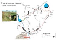
the swastika stone<br />
& hebers ghyll<br />
14<br />
walk 05<br />
3.5 Miles (5.6km)<br />
Allow 2 hours 30 mins<br />
visitilkley.com<br />
15<br />
MAP KEY:<br />
Main Route<br />
Other Paths<br />
Road<br />
Building<br />
Bridge<br />
Stream<br />
Pool<br />
01<br />
02<br />
Black Beck<br />
Spicey<br />
Gill<br />
Willy Hall’s<br />
Spout<br />
Swastika<br />
Stone<br />
<strong>ILKLEY</strong> MOOR<br />
White<br />
Wells<br />
P<br />
P<br />
Reservoir<br />
WESTWOOD DRIIVE<br />
PANORAMA DRIVE<br />
Waterworks<br />
Building<br />
Paddling<br />
Pool<br />
Apartments<br />
Hebers<br />
Ghyll<br />
Panorama<br />
Wood<br />
Cattle<br />
Grid<br />
Wells<br />
House<br />
Darwin<br />
Gardens<br />
P<br />
CROSSBECKS RD<br />
HEBERS GHYLL DRIVE<br />
Heath<br />
Park<br />
WELLS ROAD<br />
GROVE ROAD<br />
Tourist<br />
Information<br />
Centre<br />
GROVE ROAD<br />
Heathcote<br />
E<br />
Ilkley<br />
Town<br />
Centre<br />
S<br />
?<br />
Rail & Bus<br />
Station<br />
?<br />
W<br />
North<br />
0 metres 25<br />
01 Ilkley Moor.<br />
02 The Swastika Stone.<br />
This walk involves steep<br />
uphill walking and rough<br />
wood and moorland paths,<br />
therefore it is not suitable<br />
for the less mobile and<br />
pushchairs. Sensible<br />
footwear and wind and<br />
waterproof clothing is<br />
recommended along with<br />
a light snack and drink.<br />
With the information<br />
centre behind you turn<br />
left along Station Road<br />
towards the town centre.<br />
After approximately 200<br />
yards turn left up Wells<br />
Road. Walk up Wells Road<br />
for quite some distance<br />
going through the gate<br />
next to the cattle grid.<br />
Continue your climb<br />
passing on your right<br />
Darwin Gardens and the<br />
entrance to a housing<br />
development incorporating<br />
the imposing building of<br />
Wells House, and on your<br />
left high upon Ilkley Moor<br />
- White Wells Bath House.<br />
A short distance further<br />
up after the stone built<br />
former waterworks<br />
building and the entrance<br />
to White Wells car park on<br />
the left, the road divides.<br />
Turn left uphill (known<br />
locally as Weary Hill).<br />
Continue uphill to turn<br />
right off the road, as it<br />
levels out after the steep<br />
climb. Follow the welldefined<br />
footpath along the<br />
edge of Ilkley Moor keeping<br />
the houses on the right and<br />
moorland to the left.<br />
Follow this path for quite<br />
some distance, almost to<br />
the last house on the right.<br />
Look out for the wooden<br />
field gate and kissing gate<br />
on the right, here turn left<br />
over the drainage ditch<br />
onto the moor. Follow this<br />
wide path uphill as it bears<br />
right and continue straight<br />
forward through the<br />
wooden gate. From here<br />
walk straight towards the<br />
railings, which can clearly<br />
be seen ahead. Behind<br />
these railings the Swastika<br />
Stone can be found.<br />
To return take the narrow<br />
path which is to the left of,<br />
and parallel to the path on<br />
which you arrived. Walk<br />
carefully along the edge of<br />
the moor, ignore a path<br />
downhill to the left and<br />
continue straight forward<br />
for a short distance to a<br />
metal kissing gate. Once<br />
through the gate turn left<br />
off the path down the<br />
less well defined path<br />
diagonally heading towards<br />
the trees and reservoir.<br />
After a short distance the<br />
path joins several other<br />
paths under the trees near<br />
a footbridge and a metal<br />
gate. This is the top end<br />
of Hebers Ghyll and to<br />
continue your walk go<br />
through the metal gate<br />
and follow the path as it<br />
zig zags down hill crossing<br />
over several bridges to<br />
emerge onto Hebers<br />
Ghyll Drive.<br />
Turn right and follow<br />
Hebers Ghyll Drive as it<br />
bears right at its junction<br />
with Grove Road, continue<br />
down Hebers Ghyll Drive<br />
to a second junction with<br />
Grove Road, here turn right<br />
and follow Grove Road to the<br />
town centre passing along<br />
the way the mansions built<br />
by wealthy merchants at<br />
the end of the 19th century.
nesfield<br />
& upper austby<br />
16<br />
17<br />
walk 06<br />
6.5 Miles (10.4km)<br />
Allow 3 hours 30 mins<br />
visitilkley.com<br />
01 Old Bridge over River Wharfe.<br />
02 Middleton Woods.<br />
Suitable for reasonably<br />
fit. Sensible footwear,<br />
waterproof clothing and<br />
food recommended.<br />
Starting at the TIC, turn left<br />
along Station Road. Turn<br />
right across the zebra<br />
crossing, turn left and<br />
immediately right to walk<br />
down Brook Street to the<br />
traffic lights. Cross the<br />
road and walk down the left<br />
hand side of New Brook<br />
Street. After 200 yards,<br />
before the road bridge, look<br />
for the steps on the left. Go<br />
down the steps and follow<br />
the river, past the Riverside<br />
Hotel to the stone bridge.<br />
Walk across the bridge,<br />
turning left walk along the<br />
unmade path, emerging on<br />
Nesfield Road. Turn left<br />
here and cross over to the<br />
right-hand side of the road<br />
facing on-coming traffic.<br />
Continue along Nesfield<br />
Road, passing Ilkley Golf<br />
Club and the green<br />
keeper’s buildings on the<br />
left. After this the road<br />
turns sharp right. Look out<br />
for two gates in the fence<br />
on the left. Go through the<br />
smallest gate, walk<br />
straight across the golf<br />
links to another gate, which<br />
is straight ahead.<br />
Once through the gate,<br />
continue straight ahead to<br />
a stile; go through the stile<br />
and cross the road<br />
diagonally to the left and up<br />
the verge to a second stile.<br />
The path then goes left<br />
diagonally across (head for<br />
the electricity pole), to<br />
another stile. Go through<br />
the stile, onto the road,<br />
turning right to Nesfield.<br />
On entering the village<br />
the road divides. Take<br />
the road to the right and<br />
after a short distance,<br />
take another right through<br />
a gate signed ‘Dean Farm’.<br />
Follow the farm track<br />
uphill, past the farm<br />
buildings on the left.<br />
The path then leaves the<br />
track, bearing left uphill<br />
to go through a metal<br />
gate passing the stone<br />
built house.<br />
Continue to where the path<br />
divides again, following the<br />
path to the right, before<br />
climbing to reach another<br />
gate. Go through the gate<br />
bearing right onto the<br />
driveway in front of the<br />
stone house. Walk straight<br />
ahead along the drive<br />
between the farm building<br />
and yard to emerge onto<br />
the road.<br />
Turn right passing ‘Ling<br />
Park Cottage’ and some<br />
farm buildings. Walk along<br />
the road for approximately<br />
0.25 mile to where the road<br />
starts to bear left and look<br />
for a gate on the right. Go<br />
through the gate, downhill<br />
across the fields through<br />
three more gates to join an<br />
unmade road. Continue<br />
downhill, passing some<br />
cottages, before turning left<br />
at the bottom to join the<br />
entrance road to buildings<br />
at Myddelton Lodge.<br />
Continue straight on to join<br />
Hardings Lane at the T-<br />
junction, turning left to<br />
follow the road as it bears<br />
right at the junction<br />
signposted ‘Middleton’.<br />
After a short distance, just<br />
beyond the house on the<br />
right look out for the stile.<br />
Once over the stile walk to<br />
the left of the large tree at<br />
the bottom of the field for<br />
another stile into Middleton<br />
Woods. The path divides, so<br />
follow the wide track to the<br />
left across a stream. Walk<br />
along this track for 200<br />
yards. Look for a narrow<br />
woodland path on the right,<br />
marked by a large stone at<br />
its entrance. Turn right and<br />
start your descent through<br />
the woodland, down two<br />
flights of steps, across a<br />
bridge, along boardwalks,<br />
down steps and through a<br />
gate onto a road.<br />
Cross the road on the left<br />
diagonally and go down the<br />
steps to Ilkley Lido’s car<br />
park. Walk straight forward,<br />
cross the grass to a gap in<br />
the fence. Go through the<br />
gap, cross the road to the<br />
gap opposite, go through<br />
and follow the field<br />
boundary to the riverbank.<br />
Turn right to the bridge,<br />
cross the bridge, returning<br />
to the starting point.<br />
MAP KEY:<br />
Main Route<br />
Other Paths<br />
Road<br />
Stile<br />
Building<br />
Bridge<br />
Stream<br />
Pool<br />
01<br />
02<br />
Green Keepers<br />
Buildings<br />
Lower<br />
Austby<br />
NESFIELD ROAD<br />
Nesfield<br />
Ilkley<br />
Golf Links<br />
High Austby<br />
Farm<br />
Austby<br />
Owler<br />
Park<br />
RIVER WHARFE<br />
Electricity<br />
Sub-Station<br />
Ilkley<br />
Golf<br />
Club<br />
Ilkley Old Stone<br />
Bridge (circa 1675)<br />
Public House<br />
and Cafe<br />
Children’s<br />
Play Area<br />
<strong>ILKLEY</strong><br />
TOWN<br />
CENTRE<br />
OWLER PARK ROAD<br />
Dean Beck<br />
Terrace<br />
Gill<br />
Riverside<br />
Gardens<br />
Manor House<br />
Steps<br />
Upper<br />
Austby<br />
Calvary<br />
HARDINGS LANE<br />
Tourist<br />
Information<br />
Centre<br />
Myddelton<br />
Lodge<br />
DENTON ROAD<br />
The<br />
Hollies<br />
Fence<br />
Boardwalks Steps<br />
Steps<br />
Road Bridge<br />
Rail &<br />
Bus Station<br />
Rugby<br />
Ground<br />
Skateboard<br />
Area<br />
Ling<br />
Park<br />
Primrose<br />
Hill<br />
Large Stone<br />
Middleton<br />
Woods<br />
CURLY HILL<br />
Swimming Pools<br />
S<br />
E<br />
?<br />
W<br />
North<br />
?<br />
0 metres 25
18<br />
walk 07<br />
7 Miles (11.2km) circular walk<br />
with a shorter circular option<br />
5.75 Miles (9.2km)<br />
visitilkley.com<br />
19<br />
length & breadth of<br />
ilkley moor<br />
S<br />
MAP KEY:<br />
Main Route<br />
Short Cut Option<br />
Other Paths<br />
Road<br />
Stile/Gate/Gap<br />
Boundary Wall<br />
Boundary Stone<br />
Building<br />
Bridge<br />
Stream<br />
Wet Areas<br />
W<br />
E<br />
?<br />
0 metres 25<br />
North<br />
Morton Moor<br />
Rombalds Moor<br />
Thimble<br />
Stones<br />
Boundary<br />
Wall<br />
Ashlar Gate<br />
Wireless<br />
Station<br />
<strong>ILKLEY</strong> RD<br />
Trig Point<br />
(402m)<br />
Boundary<br />
Wall<br />
Rivock<br />
Plantation<br />
West Buck<br />
Stones<br />
Cowper’s<br />
Cross<br />
Whetstone<br />
Gate<br />
Stone<br />
flagged path<br />
Boardwalks<br />
East Buck<br />
Stones<br />
Shepherds<br />
Hill<br />
Heber Moss<br />
KEIGHLEY ROAD<br />
Crawshaw Moss<br />
Ilkley Moor<br />
White Wells<br />
Spa Cottage<br />
Steps<br />
Standing<br />
Boundary<br />
Stone<br />
Silver Well<br />
Cottage<br />
Weary<br />
Hill<br />
Ilkley<br />
Cragg<br />
Black<br />
Beck<br />
Wall<br />
Shooting<br />
Butts<br />
Cattle Grid<br />
Toilets<br />
Rocky<br />
Valley<br />
Steps<br />
Hebers<br />
Ghyll<br />
WESTWOOD DR<br />
Shelter<br />
Pipers<br />
Crag<br />
Swastika<br />
Stone<br />
Panoramic<br />
Reservoir<br />
Cattle<br />
Grid<br />
Ilkley Hydro<br />
(now residential)<br />
Walk Start Point<br />
Darwin Gardens car park<br />
WELLS RD<br />
Paddling<br />
Pool<br />
Suitable for reasonably<br />
fit. Sturdy footwear,<br />
outdoors clothing and<br />
packed lunch advisable.<br />
Walk onto Wells Road,<br />
turning right uphill. At the<br />
top, the road divides; take<br />
the left (Keighley Road),<br />
walk uphill to the top of the<br />
first incline where the road<br />
levels out. Turn right,<br />
follow the footpath across<br />
the grass, over a footbridge<br />
and walk parallel to the<br />
houses, through a field<br />
gate along the way. 175<br />
yards beyond the gate turn<br />
left, adjacent to two gates<br />
in the wall on your right.<br />
Continue uphill across the<br />
moor as it bears right and<br />
eventually divides. Take the<br />
path to the left; walk over a<br />
footbridge and onto a field<br />
gate. Through the gate the<br />
rough path will lead you on<br />
to the Swastika Stone.<br />
From here continue<br />
straight ahead along the<br />
escarpment of the moor,<br />
until you reach a stile in<br />
the wall (from here it’s<br />
important to count the<br />
walls you cross to ensure<br />
that you find the correct<br />
route). Climb over the stile<br />
and continue a short<br />
distance before crossing a<br />
broken down wall (no. 2).<br />
Now follow the wall on<br />
your right all the way<br />
across the field to the third<br />
wall to find the stile in the<br />
corner by a small building.<br />
Over this wall the path<br />
divides through the trees,<br />
take either paths to the<br />
fourth wall. Use the stile or<br />
go through a broken<br />
section of the wall to the<br />
stile in wall no. 5, next to a<br />
large stone at Piper’s Crag.<br />
Once over wall no. 5<br />
continue straight ahead to<br />
the gated gap in wall no.6.<br />
Go through the gate, leave<br />
the path and bear left to<br />
walk diagonally across to a<br />
stile in the wall at the top<br />
right hand side.<br />
Once over the stile the<br />
faint path bears slightly to<br />
your left. Walk up towards<br />
the skyline, parallel to the<br />
shooting butts, which can<br />
be seen to your left. At the<br />
top it levels out. Walk<br />
straight ahead to the<br />
boundary wall of the tree<br />
plantation. Once here turn<br />
left, follow the wall on<br />
your right and up the<br />
incline to the top of West<br />
Buck Stones. Then turn<br />
left, follow the wall on your<br />
right for 0.5 mile passing<br />
East Buck Stones, until you<br />
reach a wide road which is<br />
the top end of the Keighley<br />
Road (here you can cut<br />
short your walk. Turn left,<br />
walk down Keighley Road<br />
to Wells Road where<br />
you started).<br />
For the full walk, cross<br />
over Keighley Road, follow<br />
the path adjacent to the<br />
wall on your right for 1.5<br />
miles to Ashlar Chair<br />
passing Whetstone Gate<br />
and Thimble Stones.<br />
At Ashlar Chair (a large<br />
stone and two gateways in<br />
the dry stone wall on your<br />
right), turn sharp left,<br />
follow the path away from<br />
the wall and across the<br />
moor heading towards the<br />
early warning radar golf<br />
balls. After a short<br />
distance the path descends<br />
towards Ilkley. The path<br />
becomes less defined;<br />
continue downhill to a<br />
better-used path. Here<br />
turn left, walk downhill<br />
along the well-worn path,<br />
over the boardwalks to an<br />
obvious intersection of<br />
paths at Ilkley Crags<br />
overlooking Ilkley. Bear<br />
slightly to your left and<br />
down a flight of steps. At<br />
the bottom continue down<br />
the wide path until you<br />
reach trees on your right.<br />
Beyond the trees leave the<br />
main path by turning right<br />
down the much narrower<br />
path leading to the rear of<br />
White Wells.<br />
At the back of White Wells<br />
turn right, then left down<br />
the steps to the side of the<br />
building before walking<br />
down the footpath to Wells<br />
Road car park.
A65<br />
ilkley to addingham<br />
and back<br />
20<br />
21<br />
walk 08<br />
8.2 Miles (13.2km)<br />
Allow 3.5 – 4 hours<br />
visitilkley.com<br />
01 Cow & Calf Rocks.<br />
Sturdy footwear, waterproof<br />
clothing and a packed lunch<br />
is advisable. An OS map<br />
may be of assistance on<br />
this route.<br />
Fine though the riverside<br />
Dales Way path may be it<br />
cannot compare for distant<br />
views with the suggested<br />
return route.<br />
The path through Throstle<br />
Nest and Small Banks is<br />
especially lovely with the<br />
delightful hidden gill by<br />
Throstle Nest. This route<br />
crosses the old Roman<br />
Road to Ilkley just before<br />
Throstle Nest, the nearby<br />
farm named Street being<br />
an important clue to the<br />
existence of an old paved<br />
road in Anglian times.<br />
Careful attention to the<br />
map is advisable between<br />
Stockinger Lane end and<br />
the Moor edge to avoid<br />
going astray at the many<br />
turns and path junctions.<br />
The stiff climb, relieved<br />
by a level stretch at<br />
Addingham Moorside,<br />
can be further relieved<br />
by frequent pauses to<br />
admire the unfolding<br />
retrospective views.<br />
On arrival at the Moor edge<br />
the walker is rewarded,<br />
in good conditions, with<br />
a superb panorama into<br />
Upper Wharfedale.<br />
Beamsley Beacon is<br />
prominent and beyond,<br />
the winding dale is flanked<br />
by Barden Moor and Fell.<br />
To the east, the lower<br />
Dale can be seen, flanked<br />
by Almscliffe Crag and<br />
The Chevin ridge, merging<br />
gradually into the Plain<br />
of York.<br />
The path along the top<br />
of the Moor is once again<br />
part of the ancient Bronze<br />
Age track route across the<br />
Pennines which continues<br />
on to Ilkley Moor and<br />
The Chevin.<br />
The Swastika Stone by<br />
Woodhouse Crag is one of<br />
the most famous Bronze<br />
Age features in the<br />
Pennines, being a crudely<br />
carved rendering of the<br />
ancient Indo-European<br />
good luck symbol, common<br />
to ancient cultures long<br />
before its defilement by<br />
Nazi criminals during the<br />
1930s and the Second<br />
World War. Its flowing,<br />
moving shape suggests<br />
the continuity of movement<br />
perhaps of life itself, and<br />
no doubt was to frighten<br />
evil spirits away from<br />
travellers along that lonely<br />
route; not unlike, perhaps,<br />
the wayside crosses and<br />
shrines to be found<br />
through Alpine passes.<br />
Heber’s Ghyll is a<br />
delightful wooded ravine,<br />
laid out with interesting<br />
walks and stepped ways,<br />
and provides an alternative<br />
route into Ilkley through<br />
some of the grander<br />
mansions of llkley’s<br />
suburbs built on the<br />
wealth of Bradford’s once<br />
thriving wool industry.<br />
The observant may notice a<br />
rather incongruous feature<br />
on the way; the remains of<br />
a one-time golf course on<br />
the moor with levelled<br />
“greens” cut out of<br />
the slope.<br />
In the town, do not<br />
overlook the delightful<br />
path by the stream, like<br />
Heber’s Ghyll on a gentler<br />
scale, rather than the<br />
obvious Wells Road.<br />
Route supplied by Colin<br />
Speakman, from his book<br />
Dales Way Route Guide<br />
with Associated Walks by<br />
Arthur Gemmell and Colin<br />
Speakman. Colin has<br />
written many walking<br />
<strong>guide</strong>s and books, which<br />
are available in Ilkley<br />
Tourist Information Centre.<br />
MAP KEY:<br />
Main Route<br />
Other Paths<br />
Road<br />
Building<br />
Bridge<br />
Stream<br />
W<br />
North<br />
S<br />
E<br />
0 1/4 1/2m<br />
01<br />
MOORSIDE<br />
LANE<br />
Addingham<br />
High Moor<br />
Woodhouse<br />
Crag<br />
ROMBALDS<br />
MOOR<br />
ADDINGHAM<br />
MOORSIDE<br />
Cragg House<br />
Farm<br />
Swastika<br />
Stone<br />
Edge of Moor<br />
Street Farm<br />
Small<br />
Banks<br />
Farm<br />
Heber’s<br />
Ghyll<br />
<strong>ILKLEY</strong><br />
MOOR<br />
ADDINGHAM<br />
Gate in fence<br />
hidden below bank<br />
beyond trees<br />
Cocking<br />
End<br />
Buses<br />
Fence<br />
Throstle<br />
Nest<br />
Bus Stops<br />
College<br />
STOCKHINGER<br />
LANE<br />
Buses<br />
Quiet Road<br />
<strong>ILKLEY</strong><br />
A65<br />
Toilets<br />
Quiet Rd<br />
River<br />
Wharfe<br />
Golf Course<br />
Red Beck<br />
Farm<br />
Old<br />
Bridge<br />
Museum<br />
Buses<br />
MAIN STREET<br />
Weir<br />
River<br />
Wharfe<br />
Sports<br />
Centre<br />
P<br />
P<br />
Toilets<br />
Station<br />
Toilets
long distance walks/<br />
points of interest/<br />
<strong>guide</strong>d walks<br />
22 23<br />
visitilkley.com<br />
long distance walks<br />
Ebor Way<br />
Location: Helmsley<br />
to Ilkley<br />
Distance: 70 miles<br />
Linking the Cleveland Way<br />
with the Dales Way, this<br />
route from Helmsley to<br />
Ilkley provides an<br />
interesting walk across the<br />
Pennines, passing through<br />
the historic city of York.<br />
ldwa.org.uk<br />
Points of interest<br />
White Wells<br />
Middleton Woods<br />
If you enjoy a long walk<br />
or enjoy following national<br />
trails why not try one<br />
of the following routes,<br />
which include, or are<br />
close to Ilkley:<br />
Dales Way<br />
Location: Official start<br />
point Ilkley to Bownesson-Windermere<br />
Distance: 80 miles<br />
The Dales Way is a long<br />
distance footpath of about<br />
80 miles (129 km) which<br />
starts from Ilkley to<br />
Bowness-on-Windermere.<br />
The route follows as far as<br />
possible riverside paths<br />
and offers a scenically<br />
attractive route from<br />
West Yorkshire to the<br />
Lake District.<br />
dalesway.org.uk<br />
Bradford Millennium Way<br />
Location: Starting point<br />
Bracken Hall, Baildon<br />
Distance: 45 miles<br />
The Bradford Millennium<br />
Way is a 45 mile circular<br />
walk encompassing much<br />
of the idyllic countryside<br />
that surrounds the City<br />
of Bradford and includes<br />
the beautiful countryside<br />
of Ilkley & Wharfedale.<br />
Cow and Calf Rocks<br />
Location: Ilkley Moor<br />
High on Ilkley Moor the<br />
Cow and Calf Rocks are<br />
a large rock formation<br />
consisting of an outcrop<br />
and boulder, also known as<br />
Hangingstone Rocks.<br />
The rocks are made of<br />
millstone grit, a variety of<br />
sandstone, and are so<br />
named because one is<br />
large, with the smaller one<br />
sitting close to it, like a<br />
cow and calf. The rocks<br />
are a great place to climb<br />
and the moor offers<br />
spectacular views of<br />
Ilkley and beyond.<br />
Location: Ilkley Moor<br />
White Wells was instrumental<br />
in establishing Ilkley as a<br />
spa town. A number of<br />
large hydros were built in<br />
the Ilkley area during the<br />
19th century where people<br />
could come to “take the<br />
waters”, believing all<br />
manner of aliments could<br />
be cured. Charles Darwin<br />
visited Ilkley in 1859 and is<br />
believed to have “taken the<br />
waters” at White Wells.<br />
Today White Wells is a<br />
popular café and bathers<br />
can still use the plunge<br />
pool at certain times of<br />
the year! The café is open<br />
to the public whenever<br />
you see the flag flying<br />
on the building.<br />
Location: Off Denton Road<br />
near the River Wharfe<br />
Middleton Woods is famous<br />
for its colourful bluebells<br />
that covers the wood<br />
floor in May and it’s a<br />
popular place for walking<br />
and picnics.<br />
Guided walks<br />
Bradford Council’s<br />
Countryside Service run<br />
a regular programme of<br />
<strong>guide</strong>d walks, some of<br />
which include Ilkley. Visit<br />
their website or check<br />
visitbradford.com for<br />
more information.<br />
bradford.gov.uk/<br />
countryside or<br />
visitbradford.com<br />
01<br />
02<br />
01 Dales Way Signage.<br />
02 Ilkley Moor.
ilkley<br />
24<br />
25<br />
visitilkley.com<br />
Set within Wharfedale,<br />
Ilkley is the perfect place<br />
for a holiday with its<br />
magnificent countryside,<br />
fantastic restaurants and<br />
abundance of comfortable<br />
accommodation.<br />
Ilkley offers magnificent<br />
walking and countryside as<br />
well as plenty of<br />
opportunities for a fun day<br />
out. Visit the Manor House,<br />
a local museum which,<br />
stands on the remains of<br />
the Roman fort of Olicana.<br />
Only a short section of<br />
defensive wall remains<br />
exposed at the back of the<br />
building, but Roman<br />
artefacts from the fort and<br />
surrounding area are on<br />
permanent display as well<br />
as a changing programme<br />
of exhibitions. Alternatively<br />
visit Bolton Abbey estate<br />
and jump on the Embsay &<br />
Bolton Abbey Steam<br />
Railway a fantastic steam<br />
railway through the<br />
Yorkshire Dales.<br />
As well as excellent<br />
attractions, Ilkley also has<br />
an interesting events<br />
programme. Highlights<br />
include the Ilkley Summer<br />
Festival in August and the<br />
Ilkley Literature Festival<br />
in October. The Ilkley<br />
Literature Festival is<br />
one of the north’s most<br />
prestigious literature<br />
festivals and attracts the<br />
best from the worlds of<br />
literature and entertainment.<br />
Headline acts have<br />
included Jeremy Paxman,<br />
Alan Bennett, Will Self and<br />
Cherie Blair.<br />
Spend an evening relaxing<br />
and enjoying good food<br />
and drink in one of the<br />
many bars, pubs and<br />
restaurants. Michelin star<br />
restaurants also feature in<br />
Ilkley, with the Box Tree in<br />
Ilkley or the Burlington at<br />
the Devonshire Arms,<br />
Bolton Abbey, only a short<br />
drive away. Another<br />
popular choice for lunch<br />
and afternoon tea is Bettys<br />
Café & Tearooms, a<br />
Yorkshire institution<br />
serving Swiss-Yorkshire<br />
inspired fare.<br />
Nearby there are lots of<br />
interesting towns and<br />
villages and for those who<br />
enjoy shopping, theatre<br />
and culture the cities of<br />
Bradford and Leeds are<br />
also a short distance by<br />
frequent train service.<br />
To book your next<br />
holiday in Ilkley visit<br />
visitilkley.com for<br />
a great choice of hotels,<br />
guest houses and self<br />
catering accommodation.<br />
01 Ilkley high street.<br />
02 Bolton Abbey Steam Railway.<br />
01<br />
02
DRIVE<br />
ROAD<br />
MIDDLETON AVENUE<br />
VUE<br />
getting here/<br />
tic/accommodation<br />
26<br />
27<br />
map<br />
visitilkley.com<br />
getting here<br />
Public Transport<br />
As a Walkers are Welcome<br />
town we encourage the use<br />
of public transport. Ilkley<br />
is well connected by bus<br />
and trains.<br />
Public transport to Ilkey<br />
from Leeds<br />
Buses<br />
X84 – runs daily and on<br />
Sundays<br />
Trains<br />
Regular train service<br />
between Leeds and Ilkley,<br />
including a Sunday service.<br />
Public transport to Ilkley<br />
from Bradford<br />
Trains<br />
Regular train service<br />
between Bradford Forster<br />
Square and Ilkley,<br />
including a Sunday service.<br />
Public transport to Ilkley<br />
from Harrogate<br />
Buses<br />
X52 – Monday to Saturday<br />
only<br />
Trains<br />
Change at Leeds for a train<br />
to Ilkley<br />
Dales Bus Service<br />
There are many bus<br />
services within the<br />
Yorkshire Dales which run<br />
throughout the year. These<br />
are supplemented by extra<br />
services during the<br />
summer period, which<br />
mainly operate on Sundays<br />
and Bank Holidays from<br />
Easter or May Day<br />
weekends until mid-<br />
October. For more<br />
information visit<br />
dalesbus.org.<br />
Accommodation<br />
Ilkley has an abundance of<br />
quality accommodation<br />
including hotels, guest<br />
houses and self catering<br />
accommodation. Visit<br />
visitilkley.com to book<br />
your next break online!<br />
For more information on<br />
Ilkley, walking routes and<br />
the surrounding area visit<br />
Ilkley Tourist Information<br />
Centre:<br />
Ilkey Tourist<br />
Information Centre<br />
Station Road<br />
Ilkley<br />
LS29 8HB<br />
01943 602319<br />
ilkleytic@bradford.gov.uk<br />
to Golf Club<br />
LANGBAR<br />
4<br />
A65<br />
W ILTON<br />
WESTVILLE ROAD<br />
STUBHAM RISE<br />
ROAD<br />
Start of the<br />
Dales Way<br />
3<br />
2<br />
RD.<br />
PARISH<br />
PARISH<br />
GHYLL LANE<br />
QUEEN’S<br />
QUEEN’S DR.<br />
LANE<br />
1<br />
STOCKELD<br />
ROAD<br />
SKIPTON ROAD<br />
QUEEN’S<br />
KINGS<br />
EATON<br />
RO AD<br />
G HYLL<br />
DR.<br />
KINGSWAY<br />
KEIGHLEY<br />
YEWBANK<br />
TERRACE<br />
GROVE ROAD<br />
ROAD<br />
ROAD<br />
CLIFFORD<br />
Old Bridge<br />
RUPERT ROAD<br />
MIDDLETON RD.<br />
CHAPEL LA.<br />
ROAD<br />
BOLTON<br />
ST. JAMES’<br />
DRIVE<br />
WESTWOOD DRIVE<br />
A<br />
BRIDGE<br />
LISTER STREET<br />
BR I DGE<br />
OAKB U RN<br />
ROAD<br />
ROAD<br />
© Crown copyright. All rights reserved.<br />
Bradford Metropolitan District Council 100019304 2009.<br />
Produced by 2.9.09 www.fwt.co.uk<br />
GILSTEAD<br />
DENTON ROAD<br />
ALEXANDRA<br />
ROAD<br />
PRINCESS<br />
CR.<br />
LANE<br />
CHURCH<br />
REGENT ROAD<br />
GHYLL<br />
PARIS H<br />
R OAD<br />
ROAD<br />
Riverside<br />
Gardens<br />
CUNLIFFE ROAD<br />
Manor<br />
House<br />
LANE<br />
GHYLL<br />
BACK PARISH<br />
ALBANY<br />
BRODRICK<br />
W AY<br />
WEST ST.<br />
THE GROVE<br />
ROAD<br />
Bandstand<br />
RD.<br />
RIDDINGS<br />
WALK<br />
WALK<br />
WELLS<br />
QUEEN’S ROAD<br />
DR<br />
IVE<br />
NEW BROOK STREET<br />
Ilkley<br />
Playhouse<br />
Parish<br />
Church<br />
BROOK ST.<br />
PROM.<br />
WELLS<br />
WELLS<br />
WESTON<br />
ROAD<br />
STATION ROAD<br />
ROAD<br />
C O LLEGE DRIVE<br />
WELLS<br />
ROAD<br />
CASTLE<br />
LEEDS<br />
Bus Station<br />
Millennium<br />
Green<br />
0<br />
Darwin<br />
Gardens<br />
B<br />
NILE<br />
ROAD<br />
SKELD<br />
RISE<br />
A<br />
DENTON ROAD<br />
ROAD<br />
VIEW<br />
WHARFE<br />
ROAD<br />
ROAD<br />
TRAFALGAR RD.<br />
<strong>ILKLEY</strong><br />
<strong>ILKLEY</strong><br />
P ARK<br />
River Wharfe<br />
RAILWAY ROAD<br />
Ilkley Moor<br />
HALL<br />
NELSON ROAD<br />
DRIVE<br />
SE F TON<br />
WELLINGTON RD.<br />
Town Hall,<br />
Kings Hall &<br />
Winter Gardens<br />
Ilkley Toy<br />
Museum<br />
0<br />
Approximate walking time<br />
SEDBURGH PARK<br />
CROSSBECK<br />
250m<br />
5 mins<br />
White Wells<br />
Spa Cottage<br />
Ilkley<br />
Swimming Pool<br />
and Lido<br />
BATH<br />
STREET<br />
GOLDEN BUTTS<br />
ROAD<br />
BELLE<br />
ROAD<br />
BEANLANDS<br />
ASH ST.<br />
SPRINGS LANE<br />
TIVOLI PL.<br />
ASH GROVE<br />
EAST<br />
PARADE<br />
MAYFIELD ROAD<br />
RICHMOND<br />
N. PARADE<br />
PAR.<br />
LITTLE LANE<br />
PLACE<br />
COWPASTURE ROAD<br />
LEEDS ROAD A65<br />
DEAN<br />
SPR<br />
C<br />
ST.<br />
LEGEND<br />
INGFIELD<br />
AVE.<br />
B6382<br />
ASHLANDS ROAD<br />
WHEATLEY ROAD<br />
to Cow and<br />
Calf Rocks<br />
Place of Interest<br />
Public buildings<br />
Car Park<br />
Taxi ranks<br />
Public toilets with<br />
disabled facilities<br />
Tourist Information Centre
Great care has been taken in<br />
the production of this leaflet.<br />
However, the Countryside and<br />
Rights of Way Service accept<br />
no responsibility for omissions<br />
or changes which have<br />
occurred since publication.<br />
Ilkley Tourist Information Centre<br />
Station Rd<br />
Ilkley<br />
LS29 8HB<br />
01943 602319<br />
ilkleytic@bradford.gov.uk<br />
visitilkley.com