Laser Scanning - Queen's University Belfast
Laser Scanning - Queen's University Belfast
Laser Scanning - Queen's University Belfast

Create successful ePaper yourself
Turn your PDF publications into a flip-book with our unique Google optimized e-Paper software.
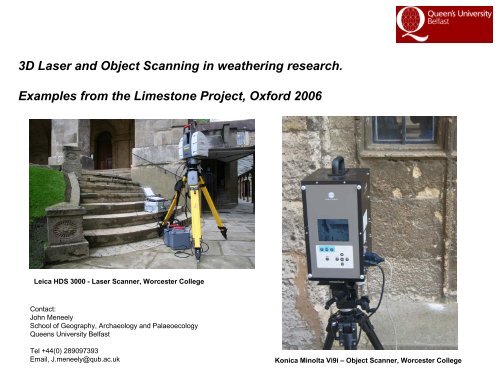
3D <strong>Laser</strong> and Object <strong>Scanning</strong> in weathering research.<br />
Examples from the Limestone Project, Oxford 2006<br />
Leica HDS 3000 - <strong>Laser</strong> Scanner, Worcester College<br />
Contact:<br />
John Meneely<br />
School of Geography, Archaeology and Palaeoecology<br />
Queens <strong>University</strong> <strong>Belfast</strong><br />
Tel +44(0) 289097393<br />
Email, J.meneely@qub.ac.uk<br />
Konica Minolta Vi9i – Object Scanner, Worcester College
What is <strong>Laser</strong> <strong>Scanning</strong>?<br />
What is <strong>Laser</strong> scanning?<br />
3d laser scanning is the complete and accurate 3d capture of ‘as is’ geometric information (xyz) quickly and<br />
unobtrusively.<br />
Complete surface geometry of exposed surfaces is remotely captured in minutes in the form of dense,<br />
accurate “3d point clouds”, ready for immediate on site use. Ground based LiDAR (light detection& ranging)<br />
• laser captures detailed and accurate<br />
surface geometry (xyz)<br />
• unprecedented speed accuracy and safety<br />
• remote surface coordinates are collected<br />
in the form of a hyper dense ‘point cloud’<br />
• measurement of surface reflectance and RGB values<br />
• point clouds immediately available for measurement and<br />
analysis<br />
• scanner is moved and rotated around the building to capture entire scene via scene registration<br />
Benefits: High Definition Scanner (HDS)<br />
•remote sensing technique (non-evasive)<br />
•speed of data collection (versus traditional methods)<br />
•number of measurements - approx 2000 points/sec<br />
•accuracy and precision - 6mm laser foot print up to 100m<br />
•data collected in real-time, measurements in real time<br />
•digital reality capture not virtual reality<br />
•Digital archive
3d scanner workflow – Brasnose College, Oxford<br />
1. Scene capture 2. point cloud data – reflectance values 3. point cloud data – RGB values<br />
4. Measure and analyse – surface elevation
3d scanner workflow – New College, Oxford<br />
1. point cloud data – reflectance 2. Measure and analyse – surface elevation<br />
3. Measure and analyse – wall sections every 0.2m<br />
Section 0.00m<br />
Section 5.80m along wall
3d laser scanner – Worcester College Buttery, Oxford<br />
2. Lidar scan – reflectance values<br />
1. Scene capture<br />
2. Point cloud - detail
What is Object <strong>Scanning</strong>?<br />
What is Object <strong>Scanning</strong> scanning?<br />
3d object scanning is the complete and accurate 3d capture of ‘as is’ geometric information (xyz) quickly<br />
and unobtrusively.<br />
The object scanner is based on the principal of laser triangulation. A target is scanned with laser stripes .<br />
The CCD camera receives the light reflected from the surface of the subject. Surface shape<br />
measurements of the subject are obtained through triangulation, and converted into a 3D polygon mesh.<br />
The object scanner measures 30720 (640 x 480) points with one scan, simultaneously acquiring surface<br />
shape data and color image data<br />
• laser captures detailed and accurate surface geometry (xyz)<br />
• unprecedented speed accuracy and safety<br />
• measurement of surface and RGB values<br />
Benefits:<br />
•The object scanner requires 2.5 seconds per scan to acquire accurate 3D data<br />
•Speed/accuracy of data collection (versus traditional methods)<br />
•Scan Range: 26mm to 1750mm<br />
•accuracy and precision - +/- 0.05, 0.008mm<br />
•data collected in real-time, measurements in real time<br />
•digital reality capture not virtual reality<br />
•digital archive
3d object scanner workflow – Worcester College Buttery, Oxford<br />
1. Scene capture 2. Scan data – single scan with surface 2. Scan data – polygon mesh<br />
3 Scan data - surface<br />
3 Scan data – RGB (False Colour)
3d object scanner – Worcester College Facade, Oxford<br />
1. Scene capture 2. Scan data – single scan with surface 3. Scan registration<br />
Photographs of ashlar blocks<br />
4. Measurement & Analysis – DEM production