Casuarina Town Centre
Casuarina Town Centre
Casuarina Town Centre

Create successful ePaper yourself
Turn your PDF publications into a flip-book with our unique Google optimized e-Paper software.
circulation and accessibility<br />
Tweed Coast Road<br />
The Boulevard<br />
Main Street<br />
<strong>Casuarina</strong> Way Gateway<br />
<strong>Casuarina</strong> Way<br />
Private Streets<br />
Local Streets<br />
Pedestrian Links<br />
Shared Paths<br />
Open Space<br />
Key Nodes<br />
Beach access<br />
vehicular<br />
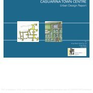
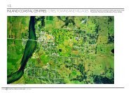
Street Hierarchy<br />
The <strong>Town</strong> <strong>Centre</strong> precinct incorporates a variety of streets and roads designed to reflect<br />
the level of activity and importance for both vehicular and pedestrian circulation, as well as<br />
their contribution to the network of open space within the precinct. The scale of the main<br />
entry Boulevard / Main Street and related trees, pathways and planting elements reflects<br />
the significant nature of this corridor, while the lesser connecting roads (<strong>Casuarina</strong> Way)<br />
and local streets are developed with a scale to pavements, planting and pedestrian facilities<br />
appropriate to their nature. As well as creating a sense of hierarchy and legibility, this<br />
approach also emphasizes the beachside nature of the centre and accessibility through a<br />
network of ‘green’ streets rather than an emphasis on vehicular traffic and cars.<br />
The local streets in the Master Plan are intended to also act as pedestrian and cycle<br />
corridors, and opportunities to collect and treat stormwater within the public realm and to<br />
infiltrate water back into the site. Flush kerbs to roadways and grassed or planted swales<br />
are proposed to integrate drainage into the landscape where possible, linking ultimately<br />
with the stormwater drainage system described in the Civil Engineers report, including the<br />
linear open space corridor of the 7f zone and other open space areas which incorporate<br />
stormwater infiltration basins.<br />
public access to foreshore<br />
An integrated open space and public access network is proposed via streets, footpaths and<br />
parks within the development to link with the existing linear park and public access way. The<br />
network will provide a more usable and functional pedestrian environment and will improve<br />
access to the beachfront zone and, through nominated links, to the beach itself. The location<br />
and treatment of public carparks and major open space areas, including the proposed<br />
Civic Park at the end of Main Street, will provide a more cohesive extension of the public<br />
circulation network and improve the integration of the foreshore to the <strong>Town</strong> <strong>Centre</strong>.<br />
pedestrian and cycle links<br />
Pathways are provided throughout the development, linking the street network, carparks and<br />
public areas to the beach access points and the public walkway / cycle path along the entire<br />
frontage of <strong>Casuarina</strong>. Pedestrian and cycle access is accommodated within the street and<br />
open space network in the Concept Plan as either defined footpaths, on road cycleways and<br />
as shared paths. A plan of the access and circulation network has been provided as part of<br />
the response to DGR.<br />
Opportunities for mid-block pedestrian links are also envisaged under the Concept Plan<br />
to enhance the permeability of the <strong>Town</strong> <strong>Centre</strong> Precinct and these will provide increased<br />
access to facilities, eg retail centre and parks as each lot is developed over time.<br />
0 <strong>Casuarina</strong> Beach <strong>Town</strong> <strong>Centre</strong><br />
Landscape Concept Report / Issue G / February 2008<br />
PDF compression, OCR, web optimization using a watermarked evaluation copy of CVISION PDFCompressor