ateam - Potsdam Institute for Climate Impact Research
ateam - Potsdam Institute for Climate Impact Research
ateam - Potsdam Institute for Climate Impact Research

Create successful ePaper yourself
Turn your PDF publications into a flip-book with our unique Google optimized e-Paper software.
ATEAM final report Section 5 and 6 (2001-2004) 96<br />
Temperature Change (Anomalies to 1961-1990)<br />
7<br />
temperature change (°C)<br />
6<br />
5<br />
4<br />
3<br />
2<br />
1<br />
0<br />
0123456789101 1213141516171819202122232425262728293031323 343536<br />
Jan<br />
Mar<br />
May<br />
July<br />
Sep<br />
Nov<br />
Jan<br />
Mar<br />
May<br />
July<br />
Sep<br />
Nov<br />
Jan<br />
Mar<br />
May<br />
July<br />
Sep<br />
Nov<br />
a1-min<br />
a1-max<br />
a2-min<br />
a2-max<br />
b1-min<br />
b1-max<br />
b2-min<br />
b2-max<br />
A<br />
2020 2050 2080<br />
30 year time slices<br />
Change in Precipitation (Anomalies to 1961-1990)<br />
precipitation change (mm)<br />
15<br />
10<br />
5<br />
0<br />
-5<br />
-10<br />
-15<br />
0123456789101 12131415161718192021222324252627282930313233343536<br />
Jan<br />
Mar<br />
May<br />
July<br />
Sep<br />
Nov<br />
Jan<br />
Mar<br />
May<br />
July<br />
Sep<br />
Nov<br />
Jan<br />
Mar<br />
May<br />
July<br />
Sep<br />
Nov<br />
a1-min<br />
a1-max<br />
a2-min<br />
a2-max<br />
b1-min<br />
b1-max<br />
b2-min<br />
b2-max<br />
B<br />
2020 2050 2080<br />
30 years time slices<br />
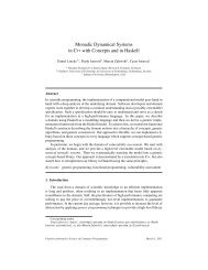
Figure 3 Change in monthly temperature (A) and precipitation (B) over the year in the time slices<br />
compared to mean monthly values of the baseline 1990 (time slices are 30 year averages: time slice<br />
1990 is an average over period 1961 – 1990, time slices 2020 is an average over period 1991 - 2020,<br />
time slice 2050 over period 2021 – 2050, and time slice 2080 over period 2051 – 2080). The curves<br />
represent the range of results in four climate models <strong>for</strong> each of the 4 SRES emission scenarios (A1f<br />
red, A2 yellow, B1 blue , B2 green). The range is depicted by the minimum and maximum value from<br />
projections with the four general circulation models per SRES scenario (Data from Mitchell et al. 2004).