ateam - Potsdam Institute for Climate Impact Research
ateam - Potsdam Institute for Climate Impact Research
ateam - Potsdam Institute for Climate Impact Research

Create successful ePaper yourself
Turn your PDF publications into a flip-book with our unique Google optimized e-Paper software.
ATEAM final report Section 5 and 6 (2001-2004) 126<br />
MDS<br />
ATN<br />
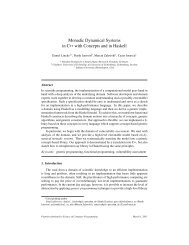
Figure 43. Summary of the changes in an ecosystem service by Environmental Zone. This figure shows the mean change in<br />
potential wheat yield compared to 1990 <strong>for</strong> Mediterranean South (MDS) and Atlantic North (ATN) <strong>for</strong> the four SRES<br />
scenarios and four Global Circulation Models (GCMs). In MDS potential wheat yield decrease dramatically, although there is<br />
considerable variability between scenarios and GCMs. In ATN wheat yield levels stay stable.<br />
potential impact<br />
adaptive capacity<br />
∆PI<br />
Sstr<br />
AC<br />
1.0<br />
0<br />
-1.0<br />
1.0<br />
0.0<br />
vulnerability<br />
AC<br />
V<br />
low<br />
high<br />
high<br />
low<br />
PI<br />
1.0<br />
0<br />
-1.0<br />
Figure 44. Vulnerability maps combine in<strong>for</strong>mation about changes in potential impact (∆PI) and adaptive capacity (AC), as<br />
illustrated by the legend. An decrease of stratified potential impact decreases vulnerability and visa versa. At the same time<br />
vulnerability is lowered by human adaptive capacity. In this visual overlay, the relationship between ∆PI and AC is not<br />
specified beyond high ∆PI and low AC result in high vulnerability. Furthermore, the scale has no unit – the map identifies<br />
areas to guide further analyses of the underlying data. The illustrative example given here is based on wood production in<br />
the Forestry sector in 2080, considering climate and land use based on A1 HadCM3.