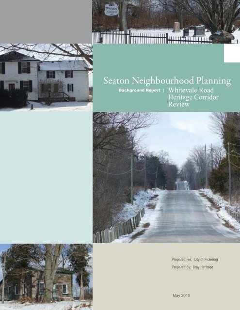
Seaton Neighbourhood Planning - City of Pickering
Seaton Neighbourhood Planning - City of Pickering
Seaton Neighbourhood Planning - City of Pickering

You also want an ePaper? Increase the reach of your titles
YUMPU automatically turns print PDFs into web optimized ePapers that Google loves.
<strong>Seaton</strong> <strong>Neighbourhood</strong> <strong>Planning</strong><br />
Background Report |<br />
Whitevale Road<br />
Heritage Corridor<br />
Review<br />
Prepared For: <strong>City</strong> <strong>of</strong> <strong>Pickering</strong><br />
Prepared By: Bray Heritage<br />
May 2010
T A B L E O F C O N T E N T S<br />
1| Background<br />
1.1| Introduction .................................................................................................................................................... 1<br />
1.2| Review <strong>of</strong> the Whitevale HCD Plan and Related Heritage Resource Studies Purpose ................. 3<br />
1.3| Summary <strong>of</strong> Heritage Significance <strong>of</strong> Whitevale HCD and the Whitevale Road Corridor.......... 5<br />
1.4| Heritage Resource Policies in the CPDP and Current <strong>Neighbourhood</strong> Plans .................................... 7<br />
2| Corridor Resource Inventory & Assessment<br />
2.1| Built Heritage Resources ...........................................................................................................................11<br />
2.2| Cultural Landscapes, Views and Archaeological Resources ..............................................................20<br />
3| Corridor Conservation & Development Strategies<br />
3.1| Principles, Goals & Objectives ................................................................................................................27<br />
3.2| Potential Designation <strong>of</strong> Whitevale Road Corridor as a Heritage Conservation District ............28<br />
3.3| Conservation Strategies for Heritage Resources in the Whitevale Road Corridor.......................31<br />
3.4| Preliminary Conclusions and Recommendations ...................................................................................44
SEATON NEIGHBOURHOOD<br />
PLANNING REVIEW<br />
WHITE V A L E R O A D H E R I T A G E C O R R I D O R R E V I E W<br />
FIGURE 1: WHITEVALE ROAD LOOKING WEST FROM SIDELINE 20<br />
1 | Background<br />
1.1| INTRODUCTION<br />
The <strong>City</strong> <strong>of</strong> <strong>Pickering</strong> is undertaking a neighbourhood planning exercise<br />
as required under the Central <strong>Pickering</strong> Development Plan for the<br />
neighbourhoods within <strong>Seaton</strong>. This neighbourhood planning exercise will<br />
result in detailed neighbourhood plans and policies to guide the form and<br />
nature <strong>of</strong> development in accordance with the Central <strong>Pickering</strong><br />
Development Plan. This includes protection <strong>of</strong> the natural heritage system;<br />
integration <strong>of</strong> cultural heritage resources; provision for a full range <strong>of</strong><br />
housing opportunities; creation <strong>of</strong> walkable mixed-use neighbourhoods,<br />
and establishment <strong>of</strong> densities which can support transit. These<br />
neighbourhood plans and policies will be approved by the <strong>City</strong> <strong>of</strong><br />
<strong>Pickering</strong> and incorporated into the <strong>City</strong>’s Official Plan.<br />
<strong>Seaton</strong> <strong>Neighbourhood</strong> <strong>Planning</strong> Review: Whitevale Road Heritage Corridor Review Page 1
As part <strong>of</strong> this work, the Central <strong>Pickering</strong> Development Plan requires<br />
background work in a number <strong>of</strong> areas, one <strong>of</strong> which is the Whitevale<br />
Road Corridor Heritage Conservation Study. BRAY Heritage has been<br />
retained to assess the potential for expanding the existing boundary <strong>of</strong><br />
the Whitevale Heritage Conservation District. This component <strong>of</strong> the<br />
project is in response to the directive from the Council <strong>of</strong> the <strong>City</strong> <strong>of</strong><br />
<strong>Pickering</strong> (January 23, 2006) stating that, “for the Central <strong>Pickering</strong><br />
Area, Council shall recognize the heritage character <strong>of</strong> the Whitevale<br />
Road Corridor and require design <strong>of</strong> new development to be compatible<br />
with the existing heritage features and sites…” and to act upon the<br />
recommendation by Heritage <strong>Pickering</strong> to consider “a potential extension<br />
<strong>of</strong> the heritage conservation district designation through <strong>Seaton</strong> along<br />
Whitevale Road, from the east limit <strong>of</strong> the existing heritage conservation<br />
district to Sideline 16, extending one half concession in width north and<br />
south <strong>of</strong> Whitevale Road and including Whitevale Road itself (the “Study<br />
Area’)”.<br />
Further in that directive is a Council resolution to have <strong>City</strong> staff<br />
undertake a heritage conservation (district) study <strong>of</strong> this area, but it is our<br />
understanding that this has not been pursued. Also, the CPCP provides<br />
cultural heritage polices for <strong>Seaton</strong> that will impact both the existing<br />
Heritage Conservation District (HCD) Study and Plan and any potential<br />
expansion <strong>of</strong> that District. It is in this context that the current study will<br />
provide the following tasks:<br />
Review the HCD Study and Plan in the context <strong>of</strong> the current<br />
policies and guidelines provided in the PPS, the OHA and the<br />
Ontario Heritage Tool Kit.<br />
Review previous inventories and evaluations <strong>of</strong> cultural heritage<br />
resources in <strong>Seaton</strong>, focusing on the Whitevale Road corridor and<br />
including the corridor from the eastern limit <strong>of</strong> the existing HCD<br />
(Sideline 26) to the eastern limit <strong>of</strong> <strong>Seaton</strong> (Sideline 16).<br />
Conduct further site analysis, site visits, and research, as needed,<br />
to provide an overall assessment <strong>of</strong> cultural heritage resources<br />
within this study area.<br />
Assess the impact <strong>of</strong> the CPDP policies and the developers’<br />
neighbourhood plans and draft plans on these resources.<br />
Propose strategies and guidelines for treatment <strong>of</strong> the Whitevale<br />
Road corridor for inclusion within the neighbourhood plans and<br />
draft plans.<br />
Propose strategies and guidelines for mitigating impact and<br />
integrating heritage resources for inclusion within the<br />
neighbourhood plans and draft plans.<br />
Page 2<br />
<strong>Seaton</strong> <strong>Neighbourhood</strong> <strong>Planning</strong> Review: Whitevale Road Heritage Corridor Review
Whitevale Road Corridor Heritage<br />
Conservation District Study<br />
Boundary<br />
Heritage Conservation District<br />
Boundary<br />
FIGURE 2: WHITEVALE ROAD CORRIDOR HERITAGE CONSERVATION DISTRICT STUDY AREA ((C) GOOGLE 2009) (MODIFIED BY AUTHOR)<br />
1.2| REVIEW OF THE WHITEVALE HCD PLAN AND RELATED HERITAGE<br />
RESOURCE STUDIES PURPOSE<br />
The cultural landscape <strong>of</strong> <strong>Seaton</strong> has been extensively studied over the<br />
years during which it has been in Provincial ownership. The relevant<br />
background studies for the current study include, but are not limited to,<br />
the following:<br />
The Hamlet <strong>of</strong> Whitevale Heritage Conservation District Study:<br />
Background Report (Unterman McPhail, August, 1989)<br />
The Hamlet <strong>of</strong> Whitevale Heritage Conservation District Study: The<br />
District Plan (Unterman McPhail, June 1990)<br />
Whitevale Heritage Conservation District: A Guide (<strong>City</strong> <strong>of</strong><br />
<strong>Pickering</strong>, n.d.)<br />
<strong>Seaton</strong> Cultural Heritage Resources Assessment (Hough Stansbury<br />
Woodland Naylor Dance, July 1994)<br />
<strong>Seaton</strong> Built Heritage Assessment (André Scheinman, November,<br />
2004)<br />
Cultural Landscape Assessment, Central <strong>Pickering</strong>: <strong>Seaton</strong> Lands<br />
(Wendy Shearer, February 28, 2006)<br />
Whitevale Heritage Conservation Distirct Extension Report<br />
(Heritage <strong>Pickering</strong>, 2006)<br />
Thematic Study and Phase I Evaluation <strong>of</strong> ORC Properties in<br />
<strong>Pickering</strong> (Contentworks, March, 2009)<br />
Phase II Evaluation <strong>of</strong> Residences on Whitevale Road, <strong>Pickering</strong> (2<br />
reports) (Contentworks, March, 2009)<br />
<strong>Seaton</strong> <strong>Neighbourhood</strong> <strong>Planning</strong> Review: Whitevale Road Heritage Corridor Review Page 3
These reports were reviewed in the context <strong>of</strong> the cultural heritage<br />
policies <strong>of</strong> the CPDP. Also reviewed were preliminary results from the<br />
archaeological resource assessment being conducted by ASI.<br />
The results <strong>of</strong> these studies can be summarized as follows:<br />
The HCD Study gives the reasons for designation <strong>of</strong> Whitevale as<br />
being largely based on the hamlet’s rural setting in an<br />
agricultural landscape. The inclusion <strong>of</strong> farm complexes and fields<br />
east <strong>of</strong> the hamlet proper (to include the intersection <strong>of</strong><br />
Whitevale Road and Sideline 26) is a result <strong>of</strong> this assessment <strong>of</strong><br />
the hamlet’s heritage significance (Background Report, Section 6).<br />
The Cultural Heritage Resources Assessment shows the variety and density<br />
<strong>of</strong> significant heritage resources along the Whitevale Road corridor,<br />
including buildings, cultural landscapes and archaeological sites (as well<br />
as natural resources), all <strong>of</strong> which relate to the area’s predominantly rural<br />
character. The composite evaluation <strong>of</strong> natural and cultural heritage<br />
resources shows that the Whitevale Corridor has the highest concentration<br />
<strong>of</strong> significant heritage resources, with the greatest integrity, <strong>of</strong> all <strong>of</strong> the<br />
<strong>Seaton</strong> area.<br />
The Built Heritage Assessment confirms the presence <strong>of</strong> many<br />
significant built heritage resources along the corridor and implies<br />
that most would be eligible for individual (Part IV) designation<br />
under the OHA.<br />
The Cultural Landscape Assessment integrates the built heritage<br />
assessment with the general assessment <strong>of</strong> cultural heritage<br />
resources by providing a more detailed inventory and evaluation<br />
<strong>of</strong> cultural landscapes within the corridor and proposing a set <strong>of</strong><br />
development guidelines for integrating these resources within new<br />
development.<br />
The Thematic Study and Phases I and II Evaluations give a<br />
contextual assessment <strong>of</strong> the heritage significance <strong>of</strong> properties<br />
along the Whitevale Road corridor in general terms, and in more<br />
detail for the ORC properties specifically. The 3 reports assessed<br />
the existing properties along the corridor but not in the context <strong>of</strong><br />
the development proposed in the CPDP. As in the previous<br />
studies, the recommendations favoured conservation <strong>of</strong> the entire<br />
context <strong>of</strong> rural roadscapes and farmsteads, including the<br />
agricultural landscapes stretching back on either side <strong>of</strong> the<br />
corridor.<br />
All <strong>of</strong> these studies appear to be based on the assumption that the current<br />
HCD Plan policies and district boundary are to remain intact and that<br />
future development will be separated from the heritage resources in such<br />
a way as to preserve, wherever possible, the dominant character <strong>of</strong> an<br />
agricultural landscape.<br />
Page 4<br />
<strong>Seaton</strong> <strong>Neighbourhood</strong> <strong>Planning</strong> Review: Whitevale Road Heritage Corridor Review
1.3| SUMMARY OF HERITAGE SIGNIFICANCE OF WHITEVALE HCD AND THE<br />
WHITEVALE ROAD CORRIDOR<br />
The HCD Study and Plan were prepared over twenty years ago, before<br />
the CPDP and its development goals for <strong>Seaton</strong>, and before the<br />
amendments to the PPS and OHA. As a result, some interpretation is<br />
needed in order to determine the heritage significance <strong>of</strong> Whitevale<br />
Hamlet and the Whitevale Road Corridor as it would be defined in the<br />
current policy context. In advance <strong>of</strong> a more detailed assessment <strong>of</strong><br />
heritage significance that would be based on information in the existing<br />
studies, and using the framework provided in the PPS and the Ontario<br />
Heritage Tool Kit, the following is a preliminary summary <strong>of</strong> heritage<br />
significance, in the form <strong>of</strong> a Heritage Character Statement.<br />
W H I T E V A L E H A M L E T H C D<br />
Reasons for Designation (following the criteria in OHA Regulation 9/06):<br />
Architectural significance in the form <strong>of</strong> excellent examples <strong>of</strong><br />
mid-to-late 19 th century houses and farm complexes<br />
Historical significance via associations with the founding <strong>of</strong><br />
Whitevale and with the main settlement period for the <strong>Pickering</strong><br />
area<br />
Contextual significance for the scenic values <strong>of</strong> the cultural and<br />
natural landscape.<br />
HERITAGE CHARACTER STATEMENT:<br />
Whitevale Hamlet is an excellent example <strong>of</strong> mid-to-late nineteenth<br />
century Ontario village architecture, and Whitevale Road is closely<br />
associated with the hamlet’s development and contains several significant<br />
nineteenth century buildings and cultural landscapes.<br />
CHARACTER-DEFINING ELEMENETS:<br />
Whitevale Hamlet HCD<br />
Placement <strong>of</strong> houses along contours <strong>of</strong> steep sided valley (hamlet)<br />
Concentration <strong>of</strong> trees along the river bank (hamlet)<br />
Cohesive, compact geometry <strong>of</strong> settlement grid (hamlet)<br />
contrasting with natural topography, river course and farm fields<br />
Vestiges <strong>of</strong> previous industrial uses (hamlet)<br />
Concentration <strong>of</strong> vernacular 19 th century housing, primarily in 1-<br />
2½ storey frame structures (hamlet)<br />
Whitevale Road Corridor<br />
Rural cross section <strong>of</strong> Whitevale Road (narrow pavement, open<br />
ditches, roadside vegetation and mature tree planting, post and<br />
wire/board fencing)<br />
<strong>Seaton</strong> <strong>Neighbourhood</strong> <strong>Planning</strong> Review: Whitevale Road Heritage Corridor Review Page 5
Undulating vertical alignment <strong>of</strong> Whitevale Road, following the<br />
existing topography<br />
Views <strong>of</strong> the natural and cultural landscape from Whitevale<br />
Road<br />
Ornamental and windbreak plantings associated with each<br />
farmstead<br />
Variety <strong>of</strong> architectural styles, materials, and ages <strong>of</strong> buildings<br />
Vestiges <strong>of</strong> related land uses (e.g. orchards, cemeteries, schools,<br />
shops) in built, cultural landscape and archaeological resources<br />
The foregoing text summarizes the elements that would be most impacted<br />
by the type and scale <strong>of</strong> development proposed in the CPDP. A more<br />
comprehensive statement <strong>of</strong> significance, describing a broader range <strong>of</strong><br />
built and cultural landscape resources, is found in the March, 2009 Phase<br />
II Evaluation report. A summary statement <strong>of</strong> significance from that report<br />
is provided below.<br />
“Collectively, the farmsteads and landscapes <strong>of</strong> Whitevale Road and<br />
Sidelines 26 and 28 represent a significant cultural landscape which<br />
speaks powerfully <strong>of</strong> agrarian life in 19th-century Ontario, and the<br />
central role it played in the history <strong>of</strong> the Province. While many <strong>of</strong><br />
the other farmsteads and individual farmhouses and barns in the<br />
<strong>Pickering</strong> study area are fine buildings, <strong>of</strong> local interest, and <strong>of</strong><br />
ongoing merit as residences, they do not individually stand out from<br />
their contemporaries for their heritage value, nor do they collectively<br />
possess the integrity and cohesiveness so striking on the Whitevale<br />
Road. Too many elements have been lost in these other areas, and<br />
too many intrusions <strong>of</strong> modern structures (such as those surveyed in<br />
this study) have limited properties and groups <strong>of</strong> properties outside <strong>of</strong><br />
the Whitevale area to meet the minimum criteria <strong>of</strong> being “heritage”<br />
for the purposes <strong>of</strong> ORC.”<br />
(Contentworks, March 2009, Phase II Evaluation, p. 13)<br />
It is clear from the foregoing summaries <strong>of</strong> heritage significance that much<br />
<strong>of</strong> the heritage value <strong>of</strong> the Whitevale Road corridor inheres in its<br />
integrity as a rural cultural landscape. With the development proposed in<br />
the CPDP, that integrity will be fundamentally altered. While new<br />
development can replace some <strong>of</strong> the incompatible 20 th century buildings<br />
that the ORC study mentions, and thus improve the overall design<br />
standard <strong>of</strong> the corridor, the road will now pass through an urbanized<br />
setting, not farmland. Within the CPDP, therefore, what can remain <strong>of</strong><br />
heritage value could be the core buildings in each <strong>of</strong> the significant<br />
farmsteads along the corridor, and the roadscape <strong>of</strong> the corridor itself. It<br />
is to these remaining heritage resources that the current study now turns.<br />
Consideration <strong>of</strong> the Whitevale Road corridor being designated as a<br />
Heritage Conservation District will be made in the following sections, as<br />
part <strong>of</strong> discussions <strong>of</strong> integrating the corridor’s cultural heritage resources<br />
within the neighbourhood plans. Alternatives to designation as an HCD<br />
will also be discussed.<br />
Page 6<br />
<strong>Seaton</strong> <strong>Neighbourhood</strong> <strong>Planning</strong> Review: Whitevale Road Heritage Corridor Review
FIGURE 3: WHTIEVALE MAP (1877, HTTP://EN.WIKIPEDIA.ORG/WIKI/WHITEVALE, ONTARIO)<br />
1.4| HERITAGE RESOURCE POLICIES IN THE CPDP AND CURRENT<br />
NEIGHBOURHOOD PLANS<br />
The CPDP has as one <strong>of</strong> its eight goals the conservation <strong>of</strong> cultural<br />
heritage resources; “The integration <strong>of</strong> cultural heritage into the new<br />
community fabric by drawing on the legacies <strong>of</strong> original aboriginal and<br />
European occupations” (CPDP, p. 20). As laid out in the Cultural Heritage<br />
objectives (Section 4.2), the ways in which this goal can be achieved in the<br />
Whitevale Road corridor include the objective to “protect and conserve<br />
significant cultural heritage features and integrate them into new urban<br />
and agricultural communities and into the Natural Heritage System” (ibid.<br />
p. 38). Note that in Section 5 <strong>of</strong> the CPDP, Implementation, all terms used<br />
in the CPDP text to describe heritage resources are the same definitions<br />
used in the PPS (ibid, p. 75).<br />
The objectives contained in Section 4.2, as they pertain to the Whitevale<br />
Road corridor, can be summarized as follows:<br />
A general presumption in favour <strong>of</strong> in-situ conservation and<br />
rehabilitation <strong>of</strong> significant cultural heritage resources (4).<br />
An overall guideline for new development “on or adjacent to<br />
protected cultural heritage properties to be <strong>of</strong> an appropriate<br />
scale and character, where the heritage attributes <strong>of</strong> such<br />
properties are conserved (9).<br />
Policies stemming from the above include:<br />
<strong>Neighbourhood</strong> plans that, where feasible, integrate cultural<br />
heritage landscape features (1 a), using the 2006 cultural<br />
landscape assessment report as a guide (1 e)<br />
<strong>Seaton</strong> <strong>Neighbourhood</strong> <strong>Planning</strong> Review: Whitevale Road Heritage Corridor Review Page 7
<strong>Neighbourhood</strong> plans that incorporate built heritage resources,<br />
with consideration to designation under the OHA (1 f)<br />
Ensure that development adjacent to the Whitevale Hamlet HCD<br />
be compatible with the District’s heritage attributes (2 a-d)<br />
Inventory, evaluation and protection in-situ wherever possible <strong>of</strong><br />
significant archaeological resources (3-9)<br />
In subsequent sections, the relationship <strong>of</strong> the Cultural Heritage goals,<br />
objectives and policies to the other elements <strong>of</strong> the CPDP is shown, as<br />
follows:<br />
In Section 4.3, Agriculture, hamlets are to continue their historic<br />
social and service function is support <strong>of</strong> the agricultural activities<br />
in the agricultural reserve. Infill and mixed uses are permitted in<br />
hamlets, including Whitevale.<br />
In Section 4.5, Transportation, upgrades to existing sidelines and<br />
Concession roads are to consider the heritage attributes <strong>of</strong> those<br />
routes (4.5.3 Policies, 7. p. 57) introduction, b) and the Whitevale<br />
Road corridor is to be given special consideration for its heritage<br />
resources, including avoidance <strong>of</strong> widening, conservation <strong>of</strong><br />
heritage resources, and consideration <strong>of</strong> the recommendations <strong>of</strong><br />
a Whitevale Road Corridor Heritage Conservation Study (c).<br />
Note: the current study is the study to which this policy refers.<br />
In Section 4.6, Servicing, there is no mention made <strong>of</strong> locating<br />
storm water management ponds away from significant cultural<br />
heritage resources, although the policies stipulate that such ponds<br />
must avoid natural heritage resources.<br />
In Section 4.8, Housing and Mixed Use, there are neighbourhood<br />
planning policies that allow for variation in lot sizes to<br />
accommodate natural or cultural heritage features (6 g).<br />
In Section 5, Implementation, the wording appears to indicate<br />
that the policies <strong>of</strong> the CPDP supersede those <strong>of</strong> the PPS, <strong>Planning</strong><br />
Act and Heritage Act, although the CPDP is to be read “in<br />
conjunction with” the PPS and <strong>Planning</strong> Act (p. 75). Should this be<br />
the case, the existing HCD Designation for Whitevale Hamlet<br />
would not be considered binding.<br />
The urban design guidelines for cultural heritage (Schedule 9, p.<br />
110) deal only with built heritage and recommend three typical<br />
conservation strategies: retention in situ (via restoration or<br />
rehabilitation) <strong>of</strong> significant built heritage resources or,<br />
relocation, or documentation and salvage <strong>of</strong> components for<br />
reuse. No guidelines are provided for cultural heritage<br />
landscapes or sites <strong>of</strong> archaeological potential.<br />
Typical neighbourhood plans and draft plans <strong>of</strong> subdivision as submitted<br />
by consultants working for the developers are at a level <strong>of</strong> generality<br />
that makes it difficult to determine if they have considered the foregoing<br />
objectives and policies for conservation and proposed integration <strong>of</strong><br />
cultural heritage resources or made provision for new development to be<br />
compatible with such resources. The extent <strong>of</strong> this integration will be<br />
reviewed below, in Section 3.3|Conservation Strategies for Heritage<br />
Resources in the Whitevale Road Corridor.<br />
Page 8<br />
<strong>Seaton</strong> <strong>Neighbourhood</strong> <strong>Planning</strong> Review: Whitevale Road Heritage Corridor Review
<strong>Seaton</strong> <strong>Neighbourhood</strong> <strong>Planning</strong> Review: Whitevale Road Heritage Corridor Review Page 9<br />
Whitevale Road Corridor Heritage<br />
Conservation District Study Boundary<br />
Heritage Conservation District Boundary<br />
FIGURE 4: CENTRAL PICKERING PLANNING AREA NEIGHBOURHOODS (P 79, CPDP) (MODIFIED BY AUTHOR)
FIGURE 5: WHITEVALE ROAD, LOOKING NORTH TO 1390<br />
2 | Corridor Resource Inventory &<br />
Assessment<br />
2.1| BUILT HERITAGE RESOURCES<br />
The following is a summary <strong>of</strong> the information found in existing inventories<br />
and evaluations <strong>of</strong> buildings along the Whitevale Road corridor east <strong>of</strong><br />
Whitevale Hamlet. Some <strong>of</strong> the properties are within the boundary <strong>of</strong> the<br />
Whitevale Hamlet HCD but most are east <strong>of</strong> that boundary in the<br />
remainder <strong>of</strong> the corridor, as far as the eastern boundary <strong>of</strong> <strong>Seaton</strong>. The<br />
information summarized below is taken from the HCD Background Report<br />
(August, 1989), the District Plan (June, 1990), the <strong>Seaton</strong> Cultural<br />
Heritage Resources Assessment (July, 1994), the <strong>Seaton</strong> Built Heritage<br />
Assessment (2004) and the 3 ORC Phase I and II Evaluations (March,<br />
2009). Reference is also made to the <strong>City</strong> <strong>of</strong> <strong>Pickering</strong> Municipal Register<br />
(March, 2008). Each <strong>of</strong> these properties is regarded as being significant<br />
as a result <strong>of</strong> a rating in the foregoing evaluations <strong>of</strong> at least Very Good<br />
or even Excellent. For details refer to the descriptions in the studies<br />
referred to above.<br />
Municipal addresses are provided for each, and numbers in brackets<br />
refer to the inventory listing numbers in the 1994 resources assessment<br />
text and mapping, but do not include the reference numbers used in the<br />
ORC Phase I and II Evaluations. “BHF” refers to Built Heritage Features<br />
and includes houses and outbuildings. Properties with an asterisk * merit<br />
further assessment for potential heritage value. “Register” indicates listing<br />
on the <strong>City</strong> <strong>of</strong> <strong>Pickering</strong> Register <strong>of</strong> heritage properties. “ORC Heritage<br />
Resource” refers to the entire property: “CR” refers to buildings within the<br />
site that are Contributing Resources.<br />
<strong>Seaton</strong> <strong>Neighbourhood</strong> <strong>Planning</strong> Review: Whitevale Road Heritage Corridor Review Page 11
From this listing and assessment it is clear that significant built heritage<br />
resources are found on both sides <strong>of</strong> the corridor from just east <strong>of</strong> the<br />
hamlet (within the HCD) to the corridor’s easterly limit. Although these<br />
resources relate to farmsteads and are therefore widely spaced, there<br />
are some concentrations <strong>of</strong> significant buildings. Clusters appear near the<br />
intersections <strong>of</strong> Sidelines with the corridor. The most important <strong>of</strong> these<br />
clusters involves properties in the immediate vicinity <strong>of</strong> Whitevale Road<br />
and Sideline 28 (Nos. 72, 73, 74 and 76). Another cluster is in the vicinity<br />
<strong>of</strong> Sideline 26 as it crosses the corridor (Nos.10, 11, 66, 69) and another<br />
near the intersection <strong>of</strong> Sideline 24 (Nos. 7, 8, 17, 18).<br />
S I G N I F I C A N T B H F s E A S T O F W H I T E V A L E W I T H I N T H E H C D<br />
#615 (76) - Henry Major House<br />
1 storey frame (1820s) and stone addition (1850s) and frame barn (1850); ORC Heritage Property, house and<br />
barn CRs<br />
#650 (75)<br />
1.5 storey frame house (1860); ORC no heritage value*<br />
Page 12<br />
<strong>Seaton</strong> <strong>Neighbourhood</strong> <strong>Planning</strong> Review: Whitevale Road Heritage Corridor Review
#3250 Sideline 28 (74) - William Turner House<br />
2 storey frame and stone (pre-1850); Register, ORC Heritage Property<br />
#700/3215 Sideline 28 (73) - Whitevale School<br />
I storey brick (1865); Register, CR<br />
#750 (72) - James White House<br />
1.5 storey stone (1861); Register, ORC Heritage Property<br />
<strong>Seaton</strong> <strong>Neighbourhood</strong> <strong>Planning</strong> Review: Whitevale Road Heritage Corridor Review Page 13
#825 (69) - Thomas Stephenson House (The Grange)<br />
2 storey frame (1855); Register, ORC Heritage Property<br />
#3185 Sideline 26 (66) - Hugh Pugh House (Pennybank)<br />
1.5 storey stone and brick (1851); Register, ORC Heritage Property, house CR<br />
#860<br />
Barn (1890); Not heritage*<br />
Page 14<br />
<strong>Seaton</strong> <strong>Neighbourhood</strong> <strong>Planning</strong> Review: Whitevale Road Heritage Corridor Review
S I G N I F I C A N T B H F s E A S T O F T H E H C D<br />
#940 (11) - John Major House<br />
1.5 storey stone and frame (1822); ORC Heritage Resource, house and barn (1870) CRs<br />
#1050 (10) - Clergy Reserve/Aaron Albright House<br />
1.5 storey brick (1861); Register, ORC Heritage Property, 3 outbuildings CRs<br />
#1125 (18) - John Tool II House/King’s College/Splatt House<br />
2.5 storey brick (1870); Register, ORC Heritage Property, house and barn (1920) CRs<br />
<strong>Seaton</strong> <strong>Neighbourhood</strong> <strong>Planning</strong> Review: Whitevale Road Heritage Corridor Review Page 15
#1130 (8) - Nathaniel Hastings House<br />
1.5 storey stone (1840); Register, ORC Heritage Property, house and barn (1870) CRs<br />
#1200 (7) - W. Brignal House<br />
2 storey brick (1877); Register, ORC Heritage Property, house and garage (1920) CRs<br />
#1255 (17) - John Tool House<br />
1.5 storey stone (1850s; ruin), barn (1870); Register<br />
Page 16<br />
<strong>Seaton</strong> <strong>Neighbourhood</strong> <strong>Planning</strong> Review: Whitevale Road Heritage Corridor Review
#1390 (6) -Joseph Willson House<br />
1.5 storey stone (1851); Register, ORC Heritage Property, house CR<br />
#1415<br />
Barn (1870); ORC Heritage Property<br />
#1450 (5) - Francis Linton House<br />
1.5 storey log (1861); Register, ORC Heritage Property, house CR<br />
<strong>Seaton</strong> <strong>Neighbourhood</strong> <strong>Planning</strong> Review: Whitevale Road Heritage Corridor Review Page 17
#1505 (15) – Caspar Willson House<br />
1.5 storey brick (1861); Register, Part IV designated<br />
#3285 Sideline 20 (4) – John Hastings House<br />
1.5 storeybrick and stone (1861)<br />
#1585 (14) - Edward Willson House<br />
1.5 storey frame house and outbuildings (1860s); ORC further research required, house and outbuildings CRs<br />
Page 18<br />
<strong>Seaton</strong> <strong>Neighbourhood</strong> <strong>Planning</strong> Review: Whitevale Road Heritage Corridor Review
#1690 (2) - Hubbard/Thompson-Glen House<br />
1.5 storey log (1840s); Register, Part IV designated, ORC Heritage Property, house and barns (1890-1900) CRs<br />
#(East <strong>of</strong> Brock Road, south side) (65)<br />
Early log structure within 20 th C. 1.5 storey frame, not on Register or owned by ORC<br />
<strong>Seaton</strong> <strong>Neighbourhood</strong> <strong>Planning</strong> Review: Whitevale Road Heritage Corridor Review Page 19
2.2| CULTURAL LANDSCAPES, VIEWS AND<br />
ARCHAEOLOGICAL RESOURCES<br />
The 1994 Assessment report rated the entire landscape on both sides <strong>of</strong><br />
the Whitevale Road corridor from Whitevale Hamlet to Brock Road as<br />
being <strong>of</strong> Very High significance, with the section east <strong>of</strong> Sideline 24<br />
having the highest integrity. The following components <strong>of</strong> this rural<br />
landscape have been identified in the 1990 HCD Plan and in the Cultural<br />
Landscape Assessment (2006) as having distinctive value and being in<br />
addition to lands within natural heritage areas. “CLU” refers to Cultural<br />
Landscape Units which, in most cases, are the farmstead (farmhouse,<br />
outbuilding, and related landscape elements and vegetation). Significant<br />
views are noted in the 1994 Resource Assessment and the 2006<br />
Landscape Assessment (the views also relate to larger viewsheds that<br />
typically extend to the mid-point <strong>of</strong> the Concession). Archaeological<br />
information is taken from 1994 Resource Assessment (cemeteries) and the<br />
<strong>Seaton</strong> <strong>Neighbourhood</strong> <strong>Planning</strong> Review. Euro-Canadian sites are<br />
farmsteads adjacent to Whitevale Road; First Nations sites have been<br />
taken into account but not identified on the report mapping, for reasons<br />
<strong>of</strong> confidentiality.<br />
The significant cultural landscapes within and abutting the corridor are,<br />
for the most part, related to farmsteads and, <strong>of</strong> these, the core areas <strong>of</strong><br />
significance are the entrance lane and farmhouse (with their related<br />
plantings), barns and other outbuildings in the vicinity <strong>of</strong> the farmhouse,<br />
and windbreak plantings. The farmsteads noted above are identified as<br />
having “significant landscape context” (Shearer 2006, p. 13), or the<br />
highest level <strong>of</strong> integrity. Of note is the overlap between significant built<br />
heritage resources and significant cultural landscapes: the identified<br />
farmsteads also contain significant buildings. Also notable is the<br />
importance <strong>of</strong> the high point on the corridor, found at the intersection <strong>of</strong><br />
Whitevale Road and Sideline 26: it has the greatest concentration <strong>of</strong><br />
significant views. Significant views are also found at Sideline 28 and at<br />
Mulberry Lane. Archaeological sites tend to be related to significant<br />
farmsteads (Euro-Canadian sites). First Nation sites have been recorded<br />
but are not delineated on the mapping.<br />
Page 20<br />
<strong>Seaton</strong> <strong>Neighbourhood</strong> <strong>Planning</strong> Review: Whitevale Road Heritage Corridor Review
<strong>Seaton</strong> <strong>Neighbourhood</strong> <strong>Planning</strong> Review: Whitevale Road Heritage Corridor Review Page 21<br />
650 (75)<br />
3250 (74)<br />
3215<br />
(73)<br />
750<br />
(72)<br />
850 (67)<br />
940 (11)<br />
1050 (10)<br />
1130 (8)<br />
1200 (7)<br />
1390 (6)<br />
1450 (5)<br />
3285<br />
4<br />
1690 (2)<br />
1710<br />
615 (76)<br />
825 (69)<br />
875<br />
3185<br />
(66)<br />
1125 (18)<br />
1255 (17)<br />
?<br />
1415<br />
1445<br />
(16)<br />
1505 (15)<br />
1585 (14)<br />
13<br />
1705<br />
1050 (10)<br />
FIGURE 6: ORC PROPERTIES (ORC, FEBRUARY 2010) (MODIFIED BY THE AUTHOR)
C L U s W I T H I N T H E H C D<br />
#700/3215 Sideline 28<br />
Former school property (perimeter trees)<br />
Unopened road allowance<br />
(Sideline 28) tree line (Maples)<br />
Roadscape<br />
(Whitevale Road) tree lined, rural cross section<br />
Page 22<br />
<strong>Seaton</strong> <strong>Neighbourhood</strong> <strong>Planning</strong> Review: Whitevale Road Heritage Corridor Review
C L U s E A S T O F T H E H C D<br />
#940 (11)<br />
#1125 (18)<br />
Farmstead (plantings and outbuildings)<br />
#1050 (10)<br />
Farmstead (plantings and outbuildings)<br />
#1450 (5)<br />
Farmstead (plantings and outbuildings)<br />
Farmstead (plantings and outbuildings)<br />
V I E W S<br />
Whitevale Road and North Road<br />
Whitevale Road and Sideline 28<br />
Southwest to West Duffins Creek<br />
South to West Duffins Creek<br />
<strong>Seaton</strong> <strong>Neighbourhood</strong> <strong>Planning</strong> Review: Whitevale Road Heritage Corridor Review Page 23
Whitevale Road and Sideline 26<br />
Whitevale Road and Mulberry Lane<br />
South to creeks<br />
South-Southwest to Lake Ontario; South to Toronto<br />
Skyline; Southwest to West Duffins Creek<br />
Whitevale Road Corridor<br />
East from Sideline 26 West from Sideline 20<br />
Page 24<br />
<strong>Seaton</strong> <strong>Neighbourhood</strong> <strong>Planning</strong> Review: Whitevale Road Heritage Corridor Review
A R C H A E O L O G I C A L S I T E S<br />
Whitevale Cemetery<br />
(Also has cultural landscape value)<br />
Hastings Cemetery<br />
Lamoreaux Cemetery<br />
<strong>Seaton</strong> <strong>Neighbourhood</strong> <strong>Planning</strong> Review: Whitevale Road Heritage Corridor Review Page 25
FIGURE 7: WHITEVALE ROAD LOOKING SOUTH-EAST TOWARDS 1505<br />
3 | Corridor Conservation &<br />
Development Strategies<br />
3.1| PRINCIPLES, GOALS & OBJECTIVES<br />
At the preliminary stages <strong>of</strong> preparing a conservation and development<br />
strategy for the Whitevale Road corridor, it is important to establish the<br />
framework within which such strategies are to be prepared. The<br />
framework is based on best practices in heritage conservation, as<br />
reflected in the federal Standards and Guidelines for the Conservation <strong>of</strong><br />
Historic Places in Canada as well as in the planning policies <strong>of</strong> the<br />
Provincial Policy Statement, the Ontario Heritage Act, and the Ontario<br />
Heritage Tool Kit. Policies found in the Central <strong>Pickering</strong> Development<br />
Plan generally follow these best conservation practices.<br />
The basic principle <strong>of</strong> the Whitevale Hamlet HCD is change management<br />
that respects the identified heritage attributes <strong>of</strong> the District. Goals and<br />
objectives for conservation and development within the Whitevale Hamlet<br />
HCD are found in the Heritage Conservation District Plan, Section 3.1:<br />
guidelines are found in Section 3.2.2. Although written in 1990, this<br />
framework is still relevant within the context <strong>of</strong> current heritage policy<br />
and practice. The remainder <strong>of</strong> the Plan contains detailed guidelines for<br />
the building and landscape works within the District, all <strong>of</strong> which are also<br />
still relevant.<br />
Central to the HCD Plan’s conservation goals is the principle <strong>of</strong><br />
conservation <strong>of</strong> heritage resources in situ, and preservation <strong>of</strong> the rural<br />
character <strong>of</strong> the hamlet. The intent is to keep as much <strong>of</strong> the surrounding<br />
rural land as possible in order for the hamlet to appear in its relevant<br />
setting.<br />
<strong>Seaton</strong> <strong>Neighbourhood</strong> <strong>Planning</strong> Review: Whitevale Road Heritage Corridor Review Page 27
3.2| POTENTIAL DESIGNATION OF WHITEVALE<br />
ROAD CORRIDOR AS A HERITAGE<br />
CONSERVATION DISTRICT<br />
The other aspect <strong>of</strong> this review is to comment on the advisability <strong>of</strong><br />
pursuing designation <strong>of</strong> the Whitevale Road corridor as a Heritage<br />
Conservation District under Part V <strong>of</strong> the Ontario Heritage Act. Criteria<br />
for District designation are found in the Ontario Heritage Tool Kit. The<br />
preconditions for studying potential designation – historical and<br />
documentary research, field studies and public participation – have<br />
largely been met by existing reports. The evaluation <strong>of</strong> the corridor’s<br />
cultural heritage resources and attributes remains to be done. The<br />
following is a preliminary review <strong>of</strong> the corridor in terms <strong>of</strong> the criteria<br />
contained in Part 3 <strong>of</strong> the Tool Kit:<br />
Historical association:<br />
o The corridor is an historic route (Conc. line 5) associated<br />
with the early settlement <strong>of</strong> the area, and containing the<br />
properties developed by early settlers<br />
Architecture:<br />
o Significant built heritage resources contribute to an<br />
understanding <strong>of</strong> various construction periods<br />
Vernacular design:<br />
o The significant built heritage resources are important<br />
local and regional examples <strong>of</strong> well-crafted buildings<br />
using local materials<br />
Integrity:<br />
o Significant built heritage resources are contained within<br />
intact farmstead complexes<br />
Architectural details:<br />
o There are a few examples <strong>of</strong> local interpretations <strong>of</strong><br />
regional/national architectural styles (e.g. cat slide ro<strong>of</strong>,<br />
dichromatic brick)<br />
Landmark status or group value:<br />
o The former school could be considered a local landmark<br />
at an important intersection<br />
Landscapes and public open spaces:<br />
o The Whitevale corridor roadscape is an important<br />
surviving example <strong>of</strong> a local rural road<br />
Overall spatial pattern:<br />
o The spatial relationship <strong>of</strong> farmsteads along the corridor<br />
contribute to the scale <strong>of</strong> the corridor<br />
Land-use:<br />
o The corridor is the spine within a distinctive rural farming<br />
landscape<br />
Circulation network and pattern:<br />
o The surviving system <strong>of</strong> open and unopened road<br />
allowances is intact from the late 19 th century<br />
Page 28 Whitevale Road Corridor Heritage Conservation District Review BRAY Heritage
Boundary and other linear features:<br />
o There are many examples <strong>of</strong> surviving boundary<br />
features, both along the corridor and around and<br />
between farmsteads<br />
Site arrangements:<br />
o The farmsteads retain their functional arrangements <strong>of</strong><br />
buildings and landscape elements<br />
Vegetation patterns:<br />
o The farming landscape contains the usual elements <strong>of</strong><br />
woodlots, watercourses, farm fields, hedgerows and the<br />
tree-lined roadway<br />
Historic views:<br />
o The views along the undulating route <strong>of</strong> Whitevale Road<br />
remain, and there is an important viewing point for areawide<br />
views at the intersection <strong>of</strong> Sideline 26<br />
The boundary <strong>of</strong> the potential district would be more difficult to define,<br />
but could be determined by the viewsheds from each side and the<br />
functional boundaries <strong>of</strong> the individual farmsteads. In that case, the<br />
boundary would be approximately one half concession deep on each<br />
side <strong>of</strong> the corridor, to the rear woodlots behind each 50 acre parcel<br />
fronting the corridor.<br />
The probable rationale for extending the HCD boundary eastwards,<br />
potentially as far as Sideline 16, would have the following components if<br />
it related to the existing rural setting:<br />
Concentration <strong>of</strong> significant cultural heritage resources – built<br />
heritage features, cultural landscape units, and archaeological<br />
resources – having a high degree <strong>of</strong> integrity<br />
Intact viewsheds along the road and to the north and south<br />
Rural landscape character <strong>of</strong> the existing roadscape<br />
Historical, architectural and contextual links between the corridor<br />
and Whitevale Hamlet, and with <strong>Seaton</strong>/<strong>Pickering</strong> as a whole<br />
Reviewing the responses to each <strong>of</strong> these criteria would indicate that, at<br />
first glance, the corridor is well suited for designation as a Heritage<br />
Conservation District. The largely intact late-19 th to early 20 th century<br />
rural landscape, largely due to the removal <strong>of</strong> development capability<br />
by Provincial expropriation for the airport lands, has provided the<br />
corridor with a varied and visually coherent rural agricultural roadscape.<br />
The March 2009 ORC report concludes that designation as an HCD would<br />
be an appropriate management response for ORC properties<br />
(Contentworks, p. 13). However, with the approval <strong>of</strong> the CPDP, the<br />
lands along the corridor will be changed from their current state to that <strong>of</strong><br />
components <strong>of</strong> urban neighbourhoods. In other words, there will no longer<br />
be a farming landscape around the individual heritage resources.<br />
<strong>Seaton</strong> <strong>Neighbourhood</strong> <strong>Planning</strong> Review: Whitevale Road Heritage Corridor Review Page 29
Page 30 <strong>Seaton</strong> <strong>Neighbourhood</strong> <strong>Planning</strong> Review: Whitevale Road Heritage Corridor Review<br />
Whitevale Road Corridor Heritage<br />
Conservation District Study Boundary<br />
Heritage Conservation District Boundary<br />
FIGURE 8: SCHEDULE 2 - LAND-USE PLAN (P 90, CPDP) (MODIFIED BY AUTHOR)
Whereas the Hamlet Heritage Open Space to the east <strong>of</strong> Whitevale will<br />
provide a buffer between the hamlet and adjacent development, in the<br />
rest <strong>of</strong> the corridor, the removal <strong>of</strong> this rural setting places the heritage<br />
resources within or adjacent to development that ranges in type from low<br />
or medium density residential to higher density mixed use nodes. The<br />
fragmentation <strong>of</strong> the corridor’s cultural landscape removes many <strong>of</strong> the<br />
reasons for designation that would otherwise have made the corridor<br />
eligible for district designation. As a result, the preliminary<br />
recommendation is to pursue options other than district designation as a<br />
means <strong>of</strong> conserving the remaining elements <strong>of</strong> the corridor roadscape.<br />
These options could include, but not be limited to:<br />
Part IV designation <strong>of</strong> significant built heritage resources (and<br />
cultural landscapes, where applicable) on individual farmsteads,<br />
including the farmhouse and associated vegetation and, in some<br />
cases, potentially including the entire working farm (fields,<br />
hedgerows, barns and other outbuildings)<br />
Part IV designation <strong>of</strong> significant cultural landscapes (e.g.<br />
cemeteries)<br />
Designation <strong>of</strong> the corridor as a Scenic Road<br />
Application <strong>of</strong> development and urban design guidelines for<br />
compatible new infill along the corridor (similar to those<br />
proposed in <strong>Neighbourhood</strong> Plans 1&2), using the existing built<br />
form and landscape layouts as prototypes<br />
Creation <strong>of</strong> a new residential district within which to place<br />
relocated significant built heritage resources (similar to the<br />
Markham heritage subdivision)<br />
3.3| CONSERVATION STRATEGIES FOR<br />
HERITAGE RESOURCES IN THE WHITEVALE<br />
ROAD CORRIDOR<br />
In this context, the realization <strong>of</strong> the CPDP will require the careful<br />
integration <strong>of</strong> the most significant elements <strong>of</strong> the existing rural landscape<br />
within new low-medium density development, and the related<br />
transportation network. To do so, the neighbourhood plans and draft<br />
plans will need to identify new road corridors so that they do not directly<br />
impact such resources, and require adjacent housing and other land uses<br />
to be designed to be compatible with the existing buildings and their<br />
associated landscapes.<br />
There are several general strategies for meeting these objectives:<br />
Buffering: screening new development from view from the<br />
heritage property through planting or fencing<br />
Integration: locating new development adjacent to heritage<br />
properties in ways that respect the property’s heritage attributes<br />
Restoration: conservation <strong>of</strong> the heritage property and reinstating<br />
missing original elements <strong>of</strong> the building and landscape<br />
<strong>Seaton</strong> <strong>Neighbourhood</strong> <strong>Planning</strong> Review: Whitevale Road Heritage Corridor Review Page 31
Relocation: moving a heritage building to a new site where it can<br />
be conserved and re-used<br />
Documentation and salvage: if a heritage property cannot be<br />
retained, recording <strong>of</strong> the property prior to demolition and<br />
salvage <strong>of</strong> important components <strong>of</strong> the physical fabric (for<br />
archaeological sites, Stage 4 documentation, excavation and<br />
removal <strong>of</strong> artifacts)<br />
S Y M B O L K E Y<br />
Inventoried Resources<br />
Significant Resources<br />
Archeological Resources<br />
These strategies can be applied to each <strong>of</strong> the <strong>Neighbourhood</strong> Plans, with<br />
the choice <strong>of</strong> strategy(s) being dependant upon the characteristics <strong>of</strong> the<br />
heritage resources found within that Plan area (note: the location <strong>of</strong> all<br />
heritage resources discussed below is approximate, based on existing<br />
mapping, and requires further research in order to determine property<br />
boundaries).<br />
The following text is a summary and assessment <strong>of</strong> each <strong>of</strong> the<br />
neighbourhood plans submitted by the landowners. The intent <strong>of</strong> this<br />
review is to assess the degree to which each <strong>of</strong> the neighbourhood plans<br />
addresses the heritage policies <strong>of</strong> the CPDP, and to make<br />
recommendations for ways in which each plan can better do so.<br />
N E I G H B O U R H O O D P L A N S 1 & 2<br />
3250 (74)<br />
650 (75)<br />
3215 (73) 750<br />
(72)<br />
615 (76)<br />
Page 32<br />
<strong>Seaton</strong> <strong>Neighbourhood</strong> <strong>Planning</strong> Review: Whitevale Road Heritage Corridor Review
<strong>Seaton</strong> <strong>Neighbourhood</strong> <strong>Planning</strong> Review: Whitevale Road Heritage Corridor Review Page 33<br />
FIGURE 9: COMPILED NEIGHBOURHOOD PLANS WITH WHITEVALE ROAD CORRIDOR CULTURAL RESOURCES (MODIFIED BY THE AUTHOR)
SUMMARY OF DEVELOPER’S SUBMISSION<br />
Moreso than in the other proposed <strong>Neighbourhood</strong> Plans, the planning<br />
text for the landowner’s proposed <strong>Neighbourhood</strong> Plans 1&2 spells out<br />
more specific responses to the many heritage resources found within this<br />
neighbourhood. The developer’s proposed <strong>Neighbourhood</strong> Plans address<br />
the CPDP policies and guidelines for cultural heritage with the heritage<br />
buffer zone and by ensuring that new development reflects the hamlet’s<br />
“existing character…particularly…east <strong>of</strong> the Hamlet along Whitevale<br />
Road” (Sect. 3.2, p. 8). Text in Section 4.4.3 Whitevale Hamlet Transition<br />
(pp. 17-18) outlines proposed heritage guidelines (as summarized in a<br />
Heritage Conservation Compliance Statement) that include:<br />
Landscape buffer east <strong>of</strong> the hamlet to the watercourse<br />
Compatible land uses in the buffer, such as organic agriculture<br />
and small scale recreational activities<br />
Diverting traffic around the hamlet, via a re-aligned North Road<br />
and a southern by-pass<br />
Conserving the existing right-<strong>of</strong>-way <strong>of</strong> Whitevale Road,<br />
minimizing impact on existing trees, heritage buildings and<br />
heritage roadscapes<br />
Retaining heritage buildings on Whitevale Road and Sideline 28<br />
“on their own generous sites” (note: it is not confirmed which<br />
properties these are, but it is assumed to mean at least the two<br />
properties outlined on the <strong>Neighbourhood</strong> Plan land use schedule)<br />
Where possible, placing “complementary uses” adjacent to<br />
heritage properties<br />
Urban design guidelines for new development that “specifically<br />
address the type <strong>of</strong> housing, lot frontages, facades and<br />
architectural elements which should be provided in order to<br />
complement the existing character <strong>of</strong> the community”<br />
In the Appendices (4.5, p. 9), more detailed guidelines are<br />
proposed for “Transitional Design from Whitevale” including:<br />
o Single detached housing only along Whitevale Road to<br />
“reflect the same housing typology as the hamlet”<br />
o Massing, ro<strong>of</strong>line and façade elements in new housing to<br />
reflect those elements as found in the existing hamlet<br />
o “historic buildings should be conserved on their own large<br />
lots and be integrated into the new <strong>Neighbourhood</strong><br />
fabric”<br />
o The Whitevale Hamlet HCD Plan and guidelines “should<br />
be respected”<br />
o The impact <strong>of</strong> new development on existing trees on<br />
heritage properties should be minimized as much as<br />
possible<br />
Page 34<br />
<strong>Seaton</strong> <strong>Neighbourhood</strong> <strong>Planning</strong> Review: Whitevale Road Heritage Corridor Review
PRELIMINARY ANALYSIS<br />
In order to meet the objectives for heritage stated in the developer’s<br />
submission, the proposed <strong>Neighbourhood</strong> Plans 1&2 should take into<br />
account the following:<br />
<strong>Neighbourhood</strong> Plan #1 contains Euro-Canadian archaeological<br />
sites on farmsteads within the HCD boundary, north and south <strong>of</strong><br />
Whitevale Road, in the Hamlet Heritage Open Space and<br />
Community Recreation Centre lands. The Plan area also appears<br />
to include a significant built heritage resource (#76)<br />
<strong>Neighbourhood</strong> Plan #2 contains both First Nations and Euro-<br />
Canadian archaeological sites (cabin site and farmsteads,<br />
respectively) as well as significant built heritage resources (#s 72,<br />
73, 74) and a significant view SW from the intersection <strong>of</strong><br />
Sideline 28. Also contained in the Natural Heritage System<br />
between <strong>Neighbourhood</strong>s 1 and 2 is a 1.5 storey frame<br />
farmhouse on a large property (650 Whitevale Road, #75).<br />
From the <strong>Neighbourhood</strong> Plan land use map, it appears that all <strong>of</strong> the<br />
features within Plan #1 can be conserved in situ, since they are within<br />
buffer or recreational lands.<br />
Both farmstead 74 and the former school at 73 appear to be conserved<br />
in situ, with their immediate surrounding landscape acting as a buffer to<br />
adjacent new development However, this buffer is probably too small to<br />
be effective. Farmstead 72 is located within the Natural Heritage System<br />
(NHS) and could be conserved in situ, with a larger portion <strong>of</strong> its<br />
surrounding landscape preserved. The neighbourhood plan should<br />
recognize through policies or land use designations the heritage<br />
properties within the NHS. This house is <strong>of</strong> local and regional significance<br />
(James White House) relating to the founding and naming <strong>of</strong> Whitevale,<br />
thus it should be made conserved within the Whitevale Corridor and<br />
<strong>Neighbourhood</strong> #2, whether it remains in residential use or is converted<br />
to another use. Note that ORC owns all <strong>of</strong> the heritage properties in these<br />
<strong>Neighbourhood</strong>s: 750/#72, 3215 Sideline 28/#73, 3250 Sideline<br />
28/#74, 650/#75, and 615/#76. The neighbourhood plans and<br />
subsequent draft plans will need to show land uses that are compatible<br />
with the existing heritage resources and lotting patterns that are <strong>of</strong> similar<br />
frontage dimensions and front yard setbacks to those found on existing<br />
heritage properties. The Whitevale Road corridor should be conserved in<br />
its existing rural cross section, with narrow paved roadway, open ditches<br />
and mature roadside trees and other vegetation.<br />
<strong>Seaton</strong> <strong>Neighbourhood</strong> <strong>Planning</strong> Review: Whitevale Road Heritage Corridor Review Page 35
N E I G H B O U R H O O D P L A N 3<br />
1050 (10)<br />
750 (72)<br />
850<br />
(67)<br />
940 (11)<br />
835 (69)<br />
875 (68)<br />
3185 (66)<br />
1050<br />
(10)<br />
SUMMARY OF DEVELOPER’S SUBMISSION<br />
This proposed <strong>Neighbourhood</strong> Plan, along with those <strong>of</strong> several <strong>of</strong> the<br />
following <strong>Neighbourhood</strong> Plans, contains few cultural heritage policies.<br />
The only mention <strong>of</strong> cultural heritage refers to the objective <strong>of</strong> excavating<br />
and protecting (or removing?) archaeological artifacts found on site<br />
(Section 3 b), p. 3).<br />
PRELIMINARY ANALYSIS<br />
From an examination <strong>of</strong> the land use plan, it appears that this proposed<br />
<strong>Neighbourhood</strong> Plan may contain the Whitevale Cemetery as well as<br />
several significant built heritage resources (Nos. 11, 67 and 69) as well<br />
as the most significant views found along the corridor, at the intersection<br />
<strong>of</strong> Sideline 26. Note that both <strong>of</strong> the built heritage resource properties<br />
are owned by ORC. No. 875 (68) Whitevale Road, a frame house<br />
situated in the Natural Heritage System, has been inventoried and<br />
evaluated as not having heritage value.<br />
The cemetery appears to have been included within an area slated for<br />
residential development: it must be conserved in situ and excluded from<br />
development. It also appears that the arterial road aligned with Sideline<br />
26 has been diverted westward before the intersection with Whitevale<br />
Road, in order to avoid built heritage resource #11, but the property is<br />
within a medium density residential area at the intersection and it is not<br />
clear how it could be integrated, nor is medium density development<br />
contemplated in the CPDP in this location. Built heritage resource #69<br />
Page 36<br />
<strong>Seaton</strong> <strong>Neighbourhood</strong> <strong>Planning</strong> Review: Whitevale Road Heritage Corridor Review
appears to be located within a low density residential area, alongside a<br />
Natural Heritage System. Given that #11 and #69 are significant built<br />
heritage resources and #11 is also a significant cultural landscape, their<br />
conservation in situ is important and should be addressed in the detailed<br />
planning and design <strong>of</strong> this <strong>Neighbourhood</strong>. No. 69 could be included<br />
within an expanded boundary <strong>of</strong> the adjacent Natural Heritage System<br />
or incorporated within an institutional site. Existing vegetation on each site<br />
should be retained and enhanced in order to provide a buffer. As noted<br />
below, provision should be made to preserve significant views in this area<br />
through careful placement and massing <strong>of</strong> new development and/or<br />
creation <strong>of</strong> public open space from which to appreciate the views,<br />
something the current plans do not do. The Whitevale Road corridor<br />
should be treated in the same way as is recommended in the previous<br />
<strong>Neighbourhood</strong> Plans.<br />
N E I G H B O U R H O O D P L A N 4<br />
825 (69)<br />
875 (68)<br />
3185 (66)<br />
1050 (10)<br />
SUMMARY OF DEVELOPER’S SUBMISSION<br />
As in the previous Plan, this proposed <strong>Neighbourhood</strong> Plan makes<br />
reference only to the excavation <strong>of</strong> archaeological resources. From<br />
examining the land use plan, it appears that this Plan area contains a<br />
significant built heritage resource (No. 66). This property appears to be<br />
located just east <strong>of</strong> the proposed arterial road extending Sideline 26<br />
south <strong>of</strong> Whitevale Road. The property is owned by ORC.<br />
<strong>Seaton</strong> <strong>Neighbourhood</strong> <strong>Planning</strong> Review: Whitevale Road Heritage Corridor Review Page 37
PRELIMINARY ANALYSIS<br />
The property is proposed by the landowner’s <strong>Neighbourhood</strong> Plan to be<br />
located within a medium density residential area at the intersection and it<br />
is not clear how it could be integrated. The medium density residential<br />
designation was not contemplated in the CPDP for this area. Key views<br />
south and west from this intersection exist within this neighbourhood but, in<br />
a medium density context, it is not clear how they will be conserved. One<br />
option would be to relocate the heritage buildings to a nearby site within<br />
a low density residential area, however, this is not recommended. Given<br />
the size and character <strong>of</strong> the farmstead complex, it would be preferable<br />
to replace the higher density node at this location with lower density<br />
development consistent with the CPDP and/or an institutional use or public<br />
open space adjacent to the conserved built heritage resource. Views<br />
could be conserved through the location <strong>of</strong> a park at the south-west<br />
corner <strong>of</strong> the intersection <strong>of</strong> Sideline 26 and Whitevale Road. As in the<br />
previous <strong>Neighbourhood</strong> Plans, the Whitevale Road corridor should be<br />
conserved in its rural state.<br />
N E I G H B O U R H O O D P L A N 5<br />
1050<br />
(10)<br />
1130<br />
(8)<br />
1200 (7)<br />
SUMMARY OF DEVELOPER’S SUBMISSION<br />
As in the previous Plan, archaeological resource excavation is the only<br />
response to cultural heritage mentioned in the text. From an examination<br />
<strong>of</strong> the land use plan, it appears that there are three significant built<br />
heritage resources (Nos.7, 8 and 10) within the Plan area. Nos. 7 and 8<br />
are owned by ORC.<br />
Page 38<br />
<strong>Seaton</strong> <strong>Neighbourhood</strong> <strong>Planning</strong> Review: Whitevale Road Heritage Corridor Review
PRELIMINARY ANALYSIS<br />
The landowner’s proposed <strong>Neighbourhood</strong> Plan appears to wrap<br />
development around the properties associated with Nos. 8 and 7 (i.e. the<br />
farmhouse and the landscape in its immediate vicinity, but not including<br />
the farm outbuildings on #8) and terms them “heritage lots”. No. 10<br />
appears to be primarily located in the Natural Heritage System west <strong>of</strong><br />
this <strong>Neighbourhood</strong>, but overlaps portions <strong>of</strong> a low density residential<br />
area and a stormwater management pond. Consideration should be<br />
given to expanding the conserved property around No. 8 in order to<br />
include the related plantings and outbuildings, and No. 10 should be<br />
conserved as a farm complex (farmhouse, plantings and outbuildings). If<br />
possible, it should be integrated in this form within the low density<br />
residential area as park or institutional space. Here, as in all <strong>of</strong> the<br />
proposed <strong>Neighbourhood</strong> Plans, treatment <strong>of</strong> the existing road right-<strong>of</strong>way<br />
in the Whitevale Road corridor has not been addressed. As will be<br />
seen in the study recommendations, the Whitevale Road corridor should<br />
be retained as a rural cross-section, as recommended for the previous<br />
<strong>Neighbourhood</strong> Plans.<br />
N E I G H B O U R H O O D P L A N 6<br />
1050<br />
(10)<br />
1125<br />
(18)<br />
1255<br />
(17)<br />
1125<br />
(18)<br />
SUMMARY OF DEVELOPER’S SUBMISSION<br />
The landowner’s proposed <strong>Neighbourhood</strong> Plan 6 has the same short<br />
policy relating to cultural heritage as do the previous 3 Plans. From<br />
examination <strong>of</strong> the land use plan, it appears that this Plan area contains<br />
two significant built heritage resources (Nos. 17 and 18), one <strong>of</strong> which<br />
(No. 18) is also a significant cultural landscape. Nos. 17 and 18 are also<br />
owned by ORC.<br />
<strong>Seaton</strong> <strong>Neighbourhood</strong> <strong>Planning</strong> Review: Whitevale Road Heritage Corridor Review Page 39
PRELIMINARY ANALYSIS<br />
Conservation <strong>of</strong> cultural heritage resource No. 18 should be confirmed by<br />
its inclusion within the proposed development, and the conserved property<br />
should include the related plantings and outbuildings. No. 17 appears to<br />
be part <strong>of</strong> a Local Node, a concentrated area <strong>of</strong> mixed uses adjacent to<br />
major roads. It is not clear how this farmstead can be integrated within<br />
such an area and the medium density land use should be reconsidered<br />
and a lower density use put there instead. However, conservation <strong>of</strong> No.<br />
17 is dependant upon an assessment <strong>of</strong> its condition, since it was already<br />
in a ruinous state when surveyed in 2006: it is assumed for the purposes<br />
<strong>of</strong> this report that the resource cannot be conserved in situ and that<br />
elements should be recorded and salvaged. The existing rural crosssection<br />
should be retained on the Whitevale Road corridor, as<br />
recommended for the previous <strong>Neighbourhood</strong> Plans.<br />
N E I G H B O U R H O O D P L A N 7<br />
1390<br />
(6) 1450 (5)<br />
1415<br />
1445 (16)<br />
Page 40<br />
<strong>Seaton</strong> <strong>Neighbourhood</strong> <strong>Planning</strong> Review: Whitevale Road Heritage Corridor Review
SUMMARY OF DEVELOPER’S SUBMISSION<br />
This proposed <strong>Neighbourhood</strong> Plan includes policies for addressing both<br />
cultural heritage resources and archaeological resources (separate<br />
policies). A cultural heritage assessment is proposed to be prepared as<br />
part <strong>of</strong> the draft plan <strong>of</strong> subdivision and the proposed development is to<br />
reflect the results <strong>of</strong> that assessment (Section 4.5, p. 16). The proposed<br />
archaeological resource policies (Section 4.6, p. 16) reflect the results <strong>of</strong><br />
the Stage 4 archaeological assessments for the Plan area and focus on<br />
respectful treatment <strong>of</strong> archaeological resources, monitoring <strong>of</strong> work in<br />
the Natural Heritage System by licensed archaeologists, and First Nations<br />
consultations.<br />
PRELIMINARY ANALYSIS<br />
From an examination <strong>of</strong> the landowner’s proposed <strong>Neighbourhood</strong> Plan,<br />
it appears that this <strong>Neighbourhood</strong> contains, or is adjacent to Natural<br />
Heritage Systems, containing two significant built heritage resources (Nos.<br />
5 and 6). Nos. 5 and 6 are owned by ORC. The barn at No. 1415<br />
Whitevale Road has also been noted as a heritage resource.<br />
No. 6 appears to be located slightly overlapping the edge <strong>of</strong> the Natural<br />
Heritage System immediately west <strong>of</strong> the Plan boundary but almost<br />
entirely within a stormwater management pond. No. 5 appears to be just<br />
outside the eastern boundary <strong>of</strong> the Plan, in the Natural Heritage System,<br />
although the farm outbuildings area within a medium density residential<br />
area. This medium density designation is more extensive than that shown<br />
in the CPDP and it is not clear how these resources would be integrated<br />
within that form <strong>of</strong> development. In both cases, their conservation as<br />
farmsteads (house, plantings and outbuildings) is warranted. The barn at<br />
No. 1415 is entirely located within a medium density residential area<br />
which again is much more extensive than contemplated by the CPDP. The<br />
barn may not be significant enough to merit conservation in situ. An<br />
alternative approach would be to record and dismantle the existing<br />
structure.<br />
<strong>Seaton</strong> <strong>Neighbourhood</strong> <strong>Planning</strong> Review: Whitevale Road Heritage Corridor Review Page 41
N E I G H B O U R H O O D P L A N 8<br />
3285 (3)<br />
(4)<br />
1505 (15)<br />
1585 (14)<br />
SUMMARY OF DEVELOPER’S SUBMISSION<br />
This landowner’s proposed <strong>Neighbourhood</strong> Plan has the same policies for<br />
cultural heritage and archaeological resources as does <strong>Neighbourhood</strong><br />
Plan 7. From examination <strong>of</strong> the land use plan, it appears that this<br />
<strong>Neighbourhood</strong> contains two significant built heritage resources (Nos. 14<br />
and 15), and significant archaeological resources. Also <strong>of</strong> note is the<br />
property at 3190 Mulberry Lane (outside <strong>of</strong> corridor) that has been<br />
evaluated in the 1994 and 2006 reports as having historical,<br />
architectural and contextual heritage significance.<br />
PRELIMINARY ANALYSIS<br />
No. 15 appears to be located at the western edge <strong>of</strong> the Plan, south <strong>of</strong><br />
Whitevale Road and west <strong>of</strong> Mulberry Lane, adjacent to the Natural<br />
Heritage System. Overlapping portions <strong>of</strong> this property appears to be an<br />
Page 42<br />
<strong>Seaton</strong> <strong>Neighbourhood</strong> <strong>Planning</strong> Review: Whitevale Road Heritage Corridor Review
area <strong>of</strong> archaeological significance, now shown as being a low density<br />
residential area in the landowner’s proposed <strong>Neighbourhood</strong> Plan. Also<br />
<strong>of</strong> note is the farmstead located at the northwest corner <strong>of</strong> Sideline 20<br />
and Whitevale Road (3285 Sideline 20). This house has not been<br />
inventoried or evaluated but appears to be a mid-19 th century frame and<br />
stone house with heritage value, on a property containing an early barn<br />
(with stone foundation), bounded by mature trees. Within the landowner’s<br />
proposed <strong>Neighbourhood</strong> Plan, No. 14 is shown as being situated in a<br />
low density area.<br />
It is our understanding that the archaeological site located within the<br />
corridor has been identified and the site merits conservation in situ. That<br />
being the case, the proposed low density development in that area will<br />
likely need to be replaced by some other form <strong>of</strong> open space or nonintensive<br />
use in the revised <strong>Neighbourhood</strong> Plan. The southern site, if<br />
outside the Plan’s development area, may be able to be retained in situ.<br />
Built heritage resource No. 15 likewise could be integrated within the low<br />
density residential area, as could Whitevale Road. Those portions <strong>of</strong> the<br />
Whitevale Road corridor that are west <strong>of</strong> the intersection with the<br />
Whitevale Road Bypass should be conserved in their current rural crosssection,<br />
as recommended above.<br />
N E I G H B O U R H O O D P L A N S 1 4 & 15<br />
The Province <strong>of</strong> Ontario has retained a consulting firm to prepare<br />
neighbourhood plans for <strong>Neighbourhood</strong>s 14 and 15. As <strong>of</strong> the time <strong>of</strong><br />
this writing, the proposed neighbourhood plans have not been prepared.<br />
PRELIMINARY ANALYSIS<br />
In advance <strong>of</strong> reviewing <strong>Neighbourhood</strong> Plan 14, it appears from the<br />
CPDP land use plan that significant built heritage resource No. 65 is<br />
located west <strong>of</strong> the Plan area, within the Natural Heritage System, and<br />
that two mid-late 19 th century farmstead archaeological sites are located<br />
just south <strong>of</strong> Whitevale Road, near the eastern edge <strong>of</strong> <strong>Seaton</strong>.<br />
Conservation <strong>of</strong> the farmstead in situ is likely possible. Conservation <strong>of</strong><br />
the archaeological resources will most likely involve some form <strong>of</strong> Stage 4<br />
mitigation.<br />
In advance <strong>of</strong> reviewing <strong>Neighbourhood</strong> Plan 15, it appears from the<br />
CPDP land use plan that significant built heritage resource No. 2 is within<br />
what is likely to be a Community Node. There may also be<br />
archaeological resources, such as the cemetery (identified only in the<br />
1994 assessment) and the sites <strong>of</strong> former buildings at the Brock Road<br />
intersection, the former crossroads community <strong>of</strong> Thompson’s Corner (not<br />
shown in <strong>Seaton</strong> <strong>Neighbourhood</strong> <strong>Planning</strong> Review <strong>of</strong> Euro-Canadian<br />
archaeological resources). Resource No. 2 is part <strong>of</strong> a large property<br />
owned by ORC.Conservation <strong>of</strong> this resource will be a challenge to<br />
integrate this small house and its heavily treed surroundings within a<br />
<strong>Seaton</strong> <strong>Neighbourhood</strong> <strong>Planning</strong> Review: Whitevale Road Heritage Corridor Review Page 43
mixed use, higher density development. Relocation may have to be<br />
considered in this case, preferably to a low density residential area in a<br />
nearby <strong>Neighbourhood</strong> (e.g. <strong>Neighbourhood</strong> 8). Conservation <strong>of</strong> the<br />
archaeological resources will most likely involve some form <strong>of</strong> Stage 4<br />
mitigation.<br />
3.4| PRELIMINARY CONCLUSIONS AND<br />
RECOMMENDATIONS<br />
The conservation and development principles found in the CPDP appear<br />
to support the overall goals and objectives found in the HCD Plan. The<br />
hamlet has been given a substantial buffer to the east as far as the first<br />
Natural Heritage System. Even so, the former Heritage Conservation<br />
District boundary has been effectively reduced such that, beyond the<br />
buffer and watercourse, the hamlet is to be surrounded by new<br />
development, not farm fields, as was the case when the HCD Plan was<br />
prepared. However, infill within the boundary <strong>of</strong> the District is to be<br />
compatible with the existing development and rural character is to be<br />
conserved within the buffer zone and adjacent natural heritage systems.<br />
Also, the CPDP policies have regard for the heritage policies <strong>of</strong> the PPS<br />
and the OHA, thus it appears that both the conservation <strong>of</strong> existing<br />
heritage resources and infill with new development are to be guided by<br />
these planning policies.<br />
The cultural heritage resources <strong>of</strong> the Whitevale Road corridor have been<br />
identified and assessed in several previous studies. The current review <strong>of</strong><br />
the <strong>Neighbourhood</strong> Plans is the next step in taking what is known about<br />
these heritage resources and applying it to a review <strong>of</strong> the<br />
<strong>Neighbourhood</strong> Plans. The following is an initial set <strong>of</strong> observations<br />
regarding the ways in which heritage has been addressed in these Plans<br />
and recommendations for future strategies to improve integration <strong>of</strong><br />
heritage resources in the process <strong>of</strong> refining these Plans.<br />
Part IV designation <strong>of</strong> individual farmsteads should be applied to<br />
the remaining ORC properties (other than the two already<br />
designated), prior to these properties being sold (assuming that<br />
they will not be retained in Provincial ownership). The Province<br />
should also proceed with this designation if the properties are to<br />
remain in Provincial ownership. This will ensure conservation <strong>of</strong><br />
these significant built heritage resources. Whitevale Cemetery<br />
should also be designated under Part IV as a cultural heritage<br />
landscape. Other significant built heritage resources now included<br />
within private lands should also be considered for Part IV<br />
designation or, at least, have heritage easements applied to<br />
conserve the resource’s heritage attributes. In situ conservation <strong>of</strong><br />
built heritage and cultural landscape resources should be a first<br />
priority, and missing or deteriorated heritage elements <strong>of</strong> the<br />
physical fabric should be restored, as part <strong>of</strong> a detailed<br />
conservation plan for each property. The Province should take an<br />
active role in this conservation activity.<br />
Page 44<br />
<strong>Seaton</strong> <strong>Neighbourhood</strong> <strong>Planning</strong> Review: Whitevale Road Heritage Corridor Review
Scenic road designation should also be pursued as a first priority,<br />
with accompanying urban design guidelines for new infill and for<br />
integration <strong>of</strong> heritage resources within new development, and<br />
for the location, grading and rights-<strong>of</strong>-way for new road and<br />
servicing infrastructure. The existing rural cross-section, with open<br />
ditches, roadside trees, vegetation and fencing, should be<br />
conserved along with the existing vertical alignment, and these<br />
heritage attributes should be identified and included within the<br />
scenic road designation, using the 2006 cultural landscape<br />
assessment as a basis.<br />
New roads designed to cross the Whitevale Road corridor will<br />
have to be designed carefully in order to minimize their impact<br />
on the heritage attributes <strong>of</strong> the road right-<strong>of</strong>-way. The<br />
undulating vertical alignment <strong>of</strong> the existing Road may be<br />
adversely affected by the gradients required to match those <strong>of</strong><br />
the crossing roads: every effort needs to be made to avoid major<br />
re-grading <strong>of</strong> Whitevale Road at each <strong>of</strong> these road crossings.<br />
Medium density development shown at intersections in the<br />
landowner’s proposed <strong>Neighbourhood</strong> Plans will have a marked<br />
impact on the rural qualities <strong>of</strong> the roadway, even more so than<br />
will the proposed low density development, if located<br />
immediately adjacent to the corridor. Rather than be an urban<br />
setting, the corridor should be lined with a combination <strong>of</strong> low<br />
density residential, oriented to face the corridor, and roadside<br />
vegetation (existing and new, compatible, infill plantings),<br />
existing farmsteads and public open space. New residential<br />
development facing the corridor should reflect the generous<br />
setbacks and screen plantings <strong>of</strong> the heritage farmsteads.<br />
Placement <strong>of</strong> new stormwater management ponds must be done<br />
in such a manner as to avoid physical and visual impact on<br />
significant heritage resources. These ponds may be screened from<br />
view from the corridor, as long as views <strong>of</strong> the heritage resources<br />
from the corridor are not obscured.<br />
Community uses, including buildings and sports fields, are<br />
permitted uses in the Hamlet buffer. In order to preserve the rural<br />
character <strong>of</strong> the buffer, such uses should be limited to outdoor<br />
recreational facilities and <strong>of</strong> a small scale and non-intrusive<br />
nature, since the intent <strong>of</strong> the hamlet buffer designation is to<br />
provide an open space buffer.<br />
New infill development along the corridor should take is design<br />
cues from the existing farmhouses. New low density residential<br />
development should be oriented to the corridor, not back-lotted,<br />
to continue the orientation pattern <strong>of</strong> the existing structures, and<br />
should form a transition to higher density development located<br />
north and south <strong>of</strong> the corridor.<br />
Although existing hedgerows, fencing and other farm-related<br />
plantings are not to be considered as impediments to<br />
development in each <strong>of</strong> the <strong>Neighbourhood</strong>s, every opportunity<br />
should be taken to integrate such landscape features with<br />
development wherever feasible.<br />
<strong>Seaton</strong> <strong>Neighbourhood</strong> <strong>Planning</strong> Review: Whitevale Road Heritage Corridor Review Page 45
Conservation <strong>of</strong> significant built heritage resources in the corridor<br />
should entail more than simply saving the building. In each case,<br />
the building and its immediate setting are <strong>of</strong> heritage significance<br />
and should be treated as a unit. Wherever possible, the house,<br />
the tree-lined drive, the gardens, windbreaks, and outbuildings,<br />
should be conserved as a whole. Since these farmsteads are<br />
relatively small in size, such a conservation strategy should have<br />
minimal impact on the development potential <strong>of</strong> the adjacent<br />
neighbourhood and will help conserve the rural character <strong>of</strong> the<br />
Whitevale Road corridor.<br />
All cemeteries identified in this study must be conserved in situ.<br />
In light <strong>of</strong> the foregoing assessment and in the context <strong>of</strong> these<br />
recommendations, the cultural heritage policies and guidelines <strong>of</strong><br />
all proposed <strong>Neighbourhood</strong> Plans should be substantially<br />
expanded and improved.<br />
Opportunities for conserving at least one complete working farm<br />
within the corridor area should be pursued, most likely within the<br />
Hamlet buffer zone but also, potentially, within the Natural<br />
Heritage Systems or as part <strong>of</strong> community recreation lands or<br />
school sites.<br />
Opportunities for interpreting the history <strong>of</strong> the corridor should<br />
be pursued, including street naming, interpretive plaques on key<br />
sites (e.g. the former schoolhouse, and the properties <strong>of</strong> important<br />
early settlers), walking and driving tours.<br />
The heritage resources and views associated with the intersections<br />
<strong>of</strong> Sidelines 28 and 26 should be assessed in greater detail and<br />
conserved within the detailed designs <strong>of</strong> the adjacent<br />
<strong>Neighbourhood</strong> Plans.<br />
<strong>Neighbourhood</strong> Plan #1 includes the eastern portion <strong>of</strong> the<br />
Whitevale Hamlet Heritage Conservation District. Low density<br />
residential development, as well as the relocated extension <strong>of</strong><br />
North Road, is now within the HCD boundary. A comprehensive<br />
conservation and development strategy, with detailed urban<br />
design guidelines, should be prepared for the proposed<br />
development within the District, and new residential development<br />
as well as the road network should be carefully sited to avoid<br />
existing heritage resources and provide a compatible setting for<br />
these resources, having regard for the policies and guidelines <strong>of</strong><br />
the 1990 HCD Plan.<br />
Should any significant built heritage resources have to be<br />
relocated, they should be placed within adjacent<br />
<strong>Neighbourhood</strong>s or, where possible, on vacant sites within the<br />
Whitevale Hamlet HCD or adjacent Hamlet Heritage Open<br />
Space.<br />
Page 46<br />
<strong>Seaton</strong> <strong>Neighbourhood</strong> <strong>Planning</strong> Review: Whitevale Road Heritage Corridor Review
As for the potential designation <strong>of</strong> the corridor as a Heritage<br />
Conservation District, it appears that most <strong>of</strong> the rural context <strong>of</strong> the<br />
farmsteads along the corridor will be fundamentally changed into an<br />
urban setting, resulting in the fragmentation <strong>of</strong> the formerly coherent<br />
cultural landscape. The result will be a series <strong>of</strong> individual heritage sites<br />
separated by new development <strong>of</strong> varying types and scales. It does not<br />
appear that the criteria for designation as an HCD can be met within the<br />
proposed development and thus designation as an HCD should not be<br />
pursued.<br />
There is also the issue <strong>of</strong> the validity <strong>of</strong> the section <strong>of</strong> the existing HCD<br />
that is east <strong>of</strong> Whitevale Hamlet Heritage Open Space but is now<br />
included within <strong>Neighbourhood</strong> #1. It remains to be determined if the<br />
impact <strong>of</strong> new development in this portion <strong>of</strong> the HCD would make the<br />
municipality consider de-designating this portion <strong>of</strong> the HCD, as it may no<br />
longer meet the reasons for designation as stated in the 1990 HCD Plan.<br />
Should de-designation be considered for that portion east <strong>of</strong> the Hamlet<br />
Heritage Open Space designation, then individual cultural heritage<br />
resources (buildings and landscapes) now within that portion <strong>of</strong> the HCD<br />
should have their property boundaries confirmed and the properties<br />
should be designated under Part IV <strong>of</strong> the Ontario Heritage Act.<br />
In conclusion, the next steps in refining the <strong>Neighbourhood</strong> Plans should<br />
treat the Whitevale Road corridor as a preserved slice <strong>of</strong> the existing<br />
rural landscape. In order to do so, such Plans should provide the corridor<br />
with the existing width retaining the existing rural cross section and<br />
related vegetation, along with significant cultural heritage resources<br />
(farmsteads and archaeological sites). The corridor’s undulating vertical<br />
alignment should be retained and significant views from the corridor<br />
should be retained and celebrated. Adjacent development should<br />
provide a transition from the preserved roadway to the built form <strong>of</strong> the<br />
adjacent neighbourhoods.This means that public open space as well as<br />
low density residential development, modeled on the architectural styles<br />
and forms <strong>of</strong> existing farmsteads, and spaced apart to match the rural<br />
typology <strong>of</strong> the existing roadscape, should be the types <strong>of</strong> development<br />
permitted in these transitional areas. If the <strong>Neighbourhood</strong> Plans can<br />
accomplish this transition, then the Whitevale Road can become a<br />
welcome contrast to the new development found elsewhere in <strong>Seaton</strong> and,<br />
in this way, become both a scenic route and a learning landscape, both<br />
displaying and interpreting the rich history <strong>of</strong> this part <strong>of</strong> <strong>Pickering</strong>.<br />
<strong>Seaton</strong> <strong>Neighbourhood</strong> <strong>Planning</strong> Review: Whitevale Road Heritage Corridor Review Page 47
L I S T O F F I G U R E S<br />
Figure 1: Whitevale Road looking west from Sideline 20 ....................................................................................................... 1<br />
Figure 2: Whitevale Road Corridor Heritage Conservation District Study Area ((C) Google 2009) (Modified by<br />
Author) ........................................................................................................................................................................................... 3<br />
Figure 3: Whtievale Map (1877, http://en.wikipedia.org/wiki/Whitevale, Ontario) ..................................................... 7<br />
Figure 4: Central <strong>Pickering</strong> <strong>Planning</strong> Area <strong>Neighbourhood</strong>s (p 79, CPDP) (Modified by Author) ................................... 9<br />
Figure 5: Whitevale Road, looking north to 1390 ................................................................................................................... 11<br />
Figure 6: ORC Properties (ORC, February 2010) (Modified by the Author) ..................................................................... 21<br />
Figure 7: Whitevale Road looking south-east towards 1505 ................................................................................................ 27<br />
Figure 8: Schedule 2 - Land-Use Plan (p 90, CpDP) (Modified by Author) ........................................................................ 30<br />
Figure 10: Compiled <strong>Neighbourhood</strong> Plans with Whitevale Road Corridor Cultural Resources (Modified by the<br />
Author) ......................................................................................................................................................................................... 33<br />
A L L P H O T O G R A P H S C O U R T E S Y O F C A R L B R A Y A N D A L I S S A G O L D E N<br />
( U N L E S S O T H E R W I S E S T A T E D )<br />
A L L A E R I A L I M A G E S C O U R T E S Y O F G O O G L E . C A © G O O G L E , 2 0 1 0<br />
F O R M A T T I N G : G O L D E N C O N S U L T I N G