São Tomé & PrÃncipe São Tomé & PrÃncipe Exclusive ... - PGS
São Tomé & PrÃncipe São Tomé & PrÃncipe Exclusive ... - PGS
São Tomé & PrÃncipe São Tomé & PrÃncipe Exclusive ... - PGS

You also want an ePaper? Increase the reach of your titles
YUMPU automatically turns print PDFs into web optimized ePapers that Google loves.
São Tomé & Príncipe <strong>Exclusive</strong> Economic Zone São Tomé & Príncipe <strong>Exclusive</strong> Economic Zone<br />
Play Fairways<br />
Four main play fairways can be proposed in the territorial waters of São Tomé and Príncipe and in the<br />
JDZ:<br />
A New Exploration Frontier<br />
• Distal toe-thrusts of the Niger Delta and more distal lower relief anticlines/swells. This play<br />
fairway, with several recent proven successes at Agbami, Nnwa and Akpo, can be clearly<br />
demonstrated to extend into the JDZ and STP waters. This structural style is illustrated on newly<br />
acquired 3D in the JDZ.<br />
• South of the toe thrust trend, drape anticlines over fracture zones occur. A number of large<br />
fracture zones are observed trending SW - NE, causing structuring of the overlying sediments.<br />
Stratigraphic traps in detached sand bodies are also demonstrated on the 2D seismic, where<br />
channels fed from the Niger delta supply reservoir to the less structured region beyond.<br />
2ºN<br />
OPL 216 OML 127<br />
NNWA OML/OPL<br />
4ºE<br />
OPL<br />
6ºE 8ºE<br />
OML 128 218 219 OML 131<br />
OPL 221 OPL 222 BLOCK C<br />
BLOCK E<br />
OPL 341 OPL 342 OPL 343 OPL 344 OPL 253 OPL 254 OPL 255 OPL 260<br />
OPL 244<br />
OPL 244<br />
AKPO<br />
OPL 245 OPL 247<br />
OPL 245<br />
OPL 246 OML 130<br />
OPL 345 OPL 346<br />
OPL 261 OPL 262 OPL 264 OPL 265<br />
OPL 266 OPL 267<br />
OPL 268 OPL 269 OPL 270 OPL 271 OPL 272 OPL 273<br />
OPL 256<br />
BLOCK 06<br />
OPL 259<br />
BLOCK 09<br />
BLOCK 01<br />
BLOCK<br />
OPL<br />
02<br />
258<br />
OPL OPL 257<br />
SAO TOME JDZ 3D<br />
BLOCK 03 BLOCK 04 BLOCK 05<br />
BLOCK 07<br />
BLOCK 10 BLOCK 11<br />
BLOCK 08<br />
F-08<br />
BLOCK J<br />
Equatorial<br />
Guinea<br />
D-13<br />
D-1<br />
E-11 E-12 E-13 E-14<br />
F-09 F-10 F-11 F-12 F-13 F-1<br />
G-09<br />
G-10 G-11 G-12 G-13 G-<br />
H-10<br />
H-11<br />
H-12 H-13 H-1<br />
I-12<br />
I-13 I-1<br />
N/K<br />
BLOCK M<br />
BLOC<br />
• The 'Cameroon Trend' of volcanic islands consists of a series of Miocene anticlines, with a thick<br />
Late Cretaceous-Miocene sedimentary section developed below outcropping Miocene-Recent<br />
volcanics, including the seeping reservoirs, as shown in the photograph overleaf.<br />
BLOCK K<br />
• The southeastern portion of STP territorial waters covers the outer continental margin of the<br />
Gabon basin. A deepwater extension to the Ogooué Delta petroleum system can be proposed here,<br />
with a major input of reservoirs likely during two Late Cretaceous lowstands. Trap types will include<br />
drape anticlines over fracture zones and stratigraphic plays in detached sand bodies<br />
Sao Tome and Principe<br />
IGOUMOU<br />
AGALI<br />
TOLO<br />
0º<br />
KIARSSEN<br />
São Tomé and Príncipe - extending proven fairways<br />
ANNOBON<br />
IGHENGUE<br />
OTITI<br />
Exploration activity has taken large leaps in recent years into waters previously considered<br />
unacceptably deep for drilling and production. Lessons learnt during Africa's exploration<br />
history indicates that technical risk is significantly lower when exploring for deepwater<br />
extensions of proven petroleum systems than in the exploration of completely unproven systems.<br />
Regional fairway mapping of deepwater West Africa has highgraded the newly defined<br />
exploration waters of São Tomé and Príncipe where extensions to the petroleum systems of Nigeria,<br />
Equatorial Guinea and Gabon occur.<br />
0<br />
50 100<br />
kilometers<br />
LEGEND<br />
<strong>PGS</strong> 2D 2005 LINES<br />
<strong>PGS</strong> 2D 2002 LINES<br />
<strong>PGS</strong> MC3D SURVEYS<br />
JOINT DEVELOPMENT ZONE<br />
LICENSED ACREAGE<br />
Gabon<br />
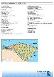
2D Seismic – <strong>PGS</strong> has acquired and processed a 11,000<br />
line km programme of high quality 2D data in the São<br />
Tomé & Príncipe <strong>Exclusive</strong> Economic Zone (EEZ).<br />
CM 2000<br />
DM 2000<br />
AKORI<br />
AZOB<br />
PINGOUIN<br />
CLAIRE<br />
ROUSSETTE<br />
ANGUILLE PORT G<br />
OCTOPUS<br />
MEROU<br />
PAGEAU<br />
LIMA<br />
GIRELLE TORPILLE EBEN<br />
PELICAN EA<br />
OBANDO TUR<br />
BAUDR<br />
MOABI<br />
N'TCH<br />
AYOL<br />
GRON<br />
BARB<br />
ABLE<br />
<strong>PGS</strong> Geophysical UK<br />
Charles Day<br />
Tel: (44) 1932 260001<br />
charles.day@pgs.com<br />
A Clearer Image<br />
www.pgs.com<br />
A Clearer Image<br />
www.pgs.com
<strong>Exclusive</strong> Economic Zone<br />
Overview<br />
<strong>PGS</strong> has entered into an<br />
exclusive agreement with the<br />
Government of São Tomé and<br />
Príncipe ("STP”) to assist in the<br />
promotion of the offshore<br />
acreage. <strong>PGS</strong> will also assist<br />
the STP Government with<br />
marketing the exploration<br />
opportunities and prospectivity<br />
of the São Tomé and Príncipe<br />
offshore to the international oil<br />
industry. To this end, <strong>PGS</strong> has<br />
acquired high quality 2D and 3D<br />
seismic data which is now<br />
available for licensing.<br />
Ubabudo 1 Well Section (drilled onshore São Tomé)<br />
Geological Setting<br />
São Tomé and Príncipe are<br />
volcanic islands lying in the<br />
Atlantic Ocean approx. 200 km<br />
south of the Nigerian coast.<br />
Their territorial waters are large,<br />
encompassing fairly deep<br />
waters but with a sediment<br />
cover that is unusually thick for<br />
such oceanic regions. This thick<br />
sediment cover represents the<br />
distal prodeltaic sediments of<br />
the Cretaceous Ogooué Delta of<br />
Gabon and the Niger Delta, the<br />
main sediment outlet during the<br />
Tertiary.<br />
Regional Tectonic Elements<br />
Oil Seep at Ubabudo 1 well location (onshore São Tomé)<br />
2D Seismic shows thick sedimentary section and structuring<br />
associated with the Fernando Po Fracture Zone<br />
A Clearer Image<br />
www.pgs.com