Forthbank Wind Energy Development - Partnerships for Renewables
Forthbank Wind Energy Development - Partnerships for Renewables Forthbank Wind Energy Development - Partnerships for Renewables
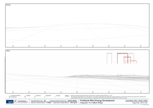
South West Craigannet (26) Craigengelt (7) / Earlsburn (4) Rullie (24) Drawing ref: W:\1871SAE - DP2 - Forthbank Feasibilty Studies\Technical\Graphics\Landscape visuals\1871 A3 VP photomontage sheets.indd Earlsburn North (13) Muirpark (16) Proposed Forthbank Develoment Installed Approved Application Scoping Notes: Numbers in brackets indicate the reference number used in cumulative diagrams ( gures 9.13 / 9.14). The wireframes are generated from a view height of 1.7m (except in cases where view is taken from a greater height due to a man made construction eg. upper oor of a building, manmade embankment etc) above a bare ground terrain model derived from OS Panorama DTM data, and adjusted for the earth’s curvature. Forthbank Wind Energy Development Viewpoint 14 | Falkirk Wheel Horizontal eld of view: 90° Viewpoint Location (OS grid ref): 285263,680000 Cumulative View - South / West Distance to nearest turbine: 11.42km Approximate viewing distance: 25cm @ A3 Figure No: CW 9.14b www.rpsgroup.com
North Torwood (30) Braes of Doune (1) Rosehill (25) Forthbank Asda Depot (5) Greenknowes (2) Grangemouth (27) East Little Raith (10) FMC Technologies (15) Drawing ref: W:\1871SAE - DP2 - Forthbank Feasibilty Studies\Technical\Graphics\Landscape visuals\1871 A3 VP photomontage sheets.indd Proposed Forthbank Develoment Installed Approved Application Scoping Horizontal eld of view: 90° Viewpoint Location (OS grid ref): 289795, 676794 Distance to nearest turbine: 13.71km Approximate viewing distance: 25cm @ A3 Notes: Numbers in brackets indicate the reference number used in cumulative diagrams ( gures 9.13 / 9.14). The wireframes are generated from a view height of 1.7m (except in cases where view is taken from a greater height due to a man made construction eg. upper oor of a building, manmade embankment etc) above a bare ground terrain model derived from OS Panorama DTM data, and adjusted for the earth’s curvature. Forthbank Wind Energy Development Viewpoint 15 | Shieldhill Cumulative View - North / East Figure No: CW 9.15a www.rpsgroup.com
- Page 9 and 10: Wireframe Standingfauld (21) Burnfo
- Page 11 and 12: Wireframe Little Raith (10) FMC tec
- Page 13 and 14: Wireframe Rullie (24) Muirpark (16)
- Page 15 and 16: North East Drawing ref: W:\1871SAE
- Page 17 and 18: North East Drawing ref: W:\1871SAE
- Page 19 and 20: North East Drawing ref: W:\1871SAE
- Page 21 and 22: North East Drawing ref: W:\1871SAE
- Page 23 and 24: North Braes of Doune (1) East FMC T
- Page 25 and 26: North Braes of Doune (1) East Forth
- Page 27 and 28: North Braes of Doune (1) East Forth
- Page 29 and 30: North Forthbank East Grangemouth (2
- Page 31 and 32: North Forthbank East Drawing ref: W
- Page 33 and 34: North Forthbank East Grangemouth (2
- Page 35 and 36: North Forthbank East Grangemouth (2
- Page 37 and 38: North Greenknowes (2) East Little R
- Page 39 and 40: North Standingfauld (21) Burnfoot (
- Page 41: North Torwood (30) Rosehill (25) Fo
- Page 45 and 46: North Braes of Doune (1) East FMC t
- Page 47 and 48: North Greenknowes (2) East Drawing
- Page 49 and 50: North Braes of Doune (1) East Forth
- Page 51 and 52: North East Forthbank Drawing ref: W
- Page 53 and 54: North Forthbank East Drawing ref: W
- Page 55 and 56: North Rosehill (25) Asda Depot (5)
- Page 57 and 58: North Earlsburn North (13) Craigeng
- Page 60 and 61: Legend Site boundary Scheduled Anci
- Page 62 and 63: Legend Site boundary 1.5km Search A
- Page 64 and 65: Legend Site boundary Category A Lis
- Page 66: Legend Site Boundary Grass Land and
- Page 69 and 70: Existing View Photomontage 1 3 2 4
- Page 71: Existing View Photomontage 1 2 3 4
- Page 74 and 75: ") Legend Site Boundary !? Turbine
- Page 76 and 77: Legend Site Boundary H Turbine loca
- Page 78 and 79: Legend Site Boundary 500m buffer Ar
- Page 80 and 81: Legend Site boundary !? Turbine loc
- Page 82 and 83: Legend Site boundary Turbine locati
- Page 84 and 85: Firth of Forth SPA, SSSI and Ramsar
- Page 86 and 87: GB HG Legend !( !( LB !( Site Bound
- Page 88 and 89: Legend Site Boundary !? !? #* SU !?
- Page 90 and 91: Legend Site Boundary Vantage point
South<br />
West<br />
Craigannet (26) Craigengelt (7) / Earlsburn (4)<br />
Rullie (24)<br />
Drawing ref: W:\1871SAE - DP2 - <strong>Forthbank</strong> Feasibilty Studies\Technical\Graphics\Landscape visuals\1871 A3 VP photomontage sheets.indd<br />
Earlsburn North (13)<br />
Muirpark (16)<br />
Proposed <strong>Forthbank</strong><br />
Develoment<br />
Installed Approved Application Scoping<br />
Notes: Numbers in brackets indicate the reference number used in cumulative diagrams ( gures 9.13 / 9.14).<br />
The wireframes are generated from a view height of 1.7m (except in cases where view is taken from a greater height due to a man made construction eg. upper oor of a building, manmade<br />
embankment etc) above a bare ground terrain model derived from OS Panorama DTM data, and adjusted <strong>for</strong> the earth’s curvature.<br />
<strong>Forthbank</strong> <strong>Wind</strong> <strong>Energy</strong> <strong>Development</strong><br />
Viewpoint 14 | Falkirk Wheel<br />
Horizontal eld of view: 90° Viewpoint Location (OS grid ref): 285263,680000<br />
Cumulative View - South / West<br />
Distance to nearest turbine: 11.42km Approximate viewing distance: 25cm @ A3<br />
Figure No: CW 9.14b<br />
www.rpsgroup.com


