Forthbank Wind Energy Development - Partnerships for Renewables
Forthbank Wind Energy Development - Partnerships for Renewables Forthbank Wind Energy Development - Partnerships for Renewables
South Asda Depot (5) Burnhead (29) Callendar Estate (28) Greendykeside (3) Greengairs (20) West Torwood (30) Rosehill (25) Rullie (24) Craigannet (26) Craigengelt (7) Earlsburn (4) Drawing ref: W:\1871SAE - DP2 - Forthbank Feasibilty Studies\Technical\Graphics\Landscape visuals\1871 A3 VP photomontage sheets.indd Muirpark (16) Earlsburn North (13) Proposed Forthbank Develoment Installed Approved Application Scoping Horizontal eld of view: 90° Viewpoint Location (OS grid ref): 289195, 688237 Distance to nearest turbine: 2.33km Approximate viewing distance: 25cm @ A3 Notes: Numbers in brackets indicate the reference number used in cumulative diagrams ( gures 9.13 / 9.14). The wireframes are generated from a view height of 1.7m (except in cases where view is taken from a greater height due to a man made construction eg. upper oor of a building, manmade embankment etc) above a bare ground terrain model derived from OS Panorama DTM data, and adjusted for the earth’s curvature. Forthbank Wind Energy Development Viewpoint 10 | Path to Pineapple Cumulative View - South / West Figure No: CW 9.10b www.rpsgroup.com
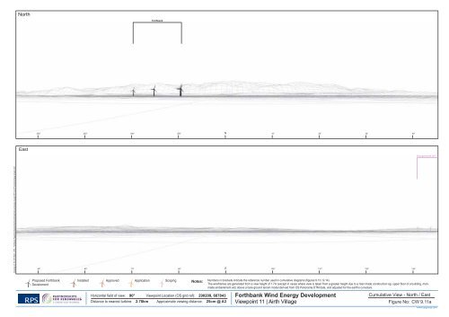
North Forthbank East Grangemouth (27) Drawing ref: W:\1871SAE - DP2 - Forthbank Feasibilty Studies\Technical\Graphics\Landscape visuals\1871 A3 VP photomontage sheets.indd Proposed Forthbank Develoment Installed Approved Application Scoping Horizontal eld of view: 90° Viewpoint Location (OS grid ref): 290209, 687843 Distance to nearest turbine: 2.70km Approximate viewing distance: 25cm @ A3 Notes: Numbers in brackets indicate the reference number used in cumulative diagrams ( gures 9.13 / 9.14). The wireframes are generated from a view height of 1.7m (except in cases where view is taken from a greater height due to a man made construction eg. upper oor of a building, manmade embankment etc) above a bare ground terrain model derived from OS Panorama DTM data, and adjusted for the earth’s curvature. Forthbank Wind Energy Development Viewpoint 11 | Airth Village Cumulative View - North / East Figure No: CW 9.11a www.rpsgroup.com
- Page 9 and 10: Wireframe Standingfauld (21) Burnfo
- Page 11 and 12: Wireframe Little Raith (10) FMC tec
- Page 13 and 14: Wireframe Rullie (24) Muirpark (16)
- Page 15 and 16: North East Drawing ref: W:\1871SAE
- Page 17 and 18: North East Drawing ref: W:\1871SAE
- Page 19 and 20: North East Drawing ref: W:\1871SAE
- Page 21 and 22: North East Drawing ref: W:\1871SAE
- Page 23 and 24: North Braes of Doune (1) East FMC T
- Page 25 and 26: North Braes of Doune (1) East Forth
- Page 27 and 28: North Braes of Doune (1) East Forth
- Page 29 and 30: North Forthbank East Grangemouth (2
- Page 31 and 32: North Forthbank East Drawing ref: W
- Page 33: North Forthbank East Grangemouth (2
- Page 37 and 38: North Greenknowes (2) East Little R
- Page 39 and 40: North Standingfauld (21) Burnfoot (
- Page 41 and 42: North Torwood (30) Rosehill (25) Fo
- Page 43 and 44: North Torwood (30) Braes of Doune (
- Page 45 and 46: North Braes of Doune (1) East FMC t
- Page 47 and 48: North Greenknowes (2) East Drawing
- Page 49 and 50: North Braes of Doune (1) East Forth
- Page 51 and 52: North East Forthbank Drawing ref: W
- Page 53 and 54: North Forthbank East Drawing ref: W
- Page 55 and 56: North Rosehill (25) Asda Depot (5)
- Page 57 and 58: North Earlsburn North (13) Craigeng
- Page 60 and 61: Legend Site boundary Scheduled Anci
- Page 62 and 63: Legend Site boundary 1.5km Search A
- Page 64 and 65: Legend Site boundary Category A Lis
- Page 66: Legend Site Boundary Grass Land and
- Page 69 and 70: Existing View Photomontage 1 3 2 4
- Page 71: Existing View Photomontage 1 2 3 4
- Page 74 and 75: ") Legend Site Boundary !? Turbine
- Page 76 and 77: Legend Site Boundary H Turbine loca
- Page 78 and 79: Legend Site Boundary 500m buffer Ar
- Page 80 and 81: Legend Site boundary !? Turbine loc
- Page 82 and 83: Legend Site boundary Turbine locati
North<br />
<strong>Forthbank</strong><br />
East<br />
Grangemouth (27)<br />
Drawing ref: W:\1871SAE - DP2 - <strong>Forthbank</strong> Feasibilty Studies\Technical\Graphics\Landscape visuals\1871 A3 VP photomontage sheets.indd<br />
Proposed <strong>Forthbank</strong><br />
Develoment<br />
Installed Approved Application Scoping<br />
Horizontal eld of view: 90° Viewpoint Location (OS grid ref): 290209, 687843<br />
Distance to nearest turbine: 2.70km Approximate viewing distance: 25cm @ A3<br />
Notes: Numbers in brackets indicate the reference number used in cumulative diagrams ( gures 9.13 / 9.14).<br />
The wireframes are generated from a view height of 1.7m (except in cases where view is taken from a greater height due to a man made construction eg. upper oor of a building, manmade<br />
embankment etc) above a bare ground terrain model derived from OS Panorama DTM data, and adjusted <strong>for</strong> the earth’s curvature.<br />
<strong>Forthbank</strong> <strong>Wind</strong> <strong>Energy</strong> <strong>Development</strong><br />
Viewpoint 11 | Airth Village<br />
Cumulative View - North / East<br />
Figure No: CW 9.11a<br />
www.rpsgroup.com


