Appendix 8.1 Cultural Heritage Desk Based Assessment
Appendix 8.1 Cultural Heritage Desk Based Assessment
Appendix 8.1 Cultural Heritage Desk Based Assessment

You also want an ePaper? Increase the reach of your titles
YUMPU automatically turns print PDFs into web optimized ePapers that Google loves.
CLOICH WIND FARM, SCOTTISH BORDERS<br />
SCOTTISH BORDERS COUNCIL<br />
National Grid Reference (NGR) NS 69 85<br />
<strong>Desk</strong>-based <strong>Assessment</strong> of <strong>Cultural</strong> <strong>Heritage</strong> Resources<br />
Prepared by:<br />
RPS Planning and Development<br />
March 2012<br />
RPS Planning and Development<br />
Mallams Court<br />
18 Milton Park<br />
Abingdon<br />
Oxon<br />
OX14 4RP<br />
Tel 01235 821888<br />
Fax 01235 820351<br />
Email rpsox@rpsplc.co.uk
Contents<br />
Summary................................................................................................ iii<br />
1 Introduction ................................................................................... 1<br />
2 Legislative and Planning Framework ............................................. 4<br />
3 Baseline Data ................................................................................ 9<br />
4 Previous Impacts ........................................................................ 18<br />
5 <strong>Assessment</strong> of Archaeological Potential ..................................... 19<br />
6 Development Proposal and Likely Impacts ................................. 21<br />
7 Conclusions and Recommendations ........................................... 22<br />
8 Bibliography ................................................................................ 23<br />
RPS Planning and Development<br />
May 2012<br />
i<br />
Cloich Wind Farm
Figures<br />
Figure 1<br />
Figure 2<br />
Figure 3<br />
Map showing the location of the proposed windfarm and sites of<br />
archaeological/historical significance<br />
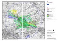
ZTV with Listed Buildings and Scheduled Monuments within 10km<br />
Detail from Gordon’s map (c.1536-62) of the Tweedale<br />
Figure 4 Detail from Blaeu Atlas (1654)<br />
Figure 5<br />
Figure 6<br />
Figure 7<br />
Detail from Roy map (1747-55) Military Survey of Scotland. Sheet 7/4a.<br />
Detail of 1856 6-inch OS first edition showing area around Courhope/southern part of<br />
wind farm site<br />
Detail of 1856 6-inch OS first edition showing northern part of proposed wind farm site<br />
Appendices<br />
<strong>Appendix</strong> I:<br />
Gazetteer of Sites of Archaeological/Historical Interest<br />
RPS Planning and Development<br />
May 2012<br />
ii<br />
Cloich Wind Farm
Summary<br />
This archaeological desk-based assessment has been prepared to inform a forthcoming Environmental<br />
Statement and planning application for the construction a wind farm within in the Scottish Forestry<br />
Commission’s Cloich Forest in the north-western Scottish Borders. It has been prepared in accordance<br />
with the standards and guidelines of the Institute for Archaeologists (IFA), and the latest government<br />
policy and guidance: Scottish Planning Policy (SPP), Scottish Historic Environment Policy (SHEP),<br />
Planning Advice Note 2/2011: Planning and Archaeology (PAN 2) and the relevant guidance notes on<br />
Managing Change in the Historic Environment produced by Historic Scotland (HS).<br />
The proposed wind farm site lies on upland in the north-western Scottish borders. It lies c.7km north-west<br />
of Peebles within the Forestry Commission Scotland (FCS) Cloich Forest, a large conifer plantation. The<br />
hills lie between the Eddleston Valley to the east, the valleys of Cairn Burn to the north-west and Lyne<br />
Water to the south-west with the Tweed Valley to the south. The site falls just inside the western<br />
boundary of Eddleston parish.<br />
The area to the west, south and east of the site is exceptionally rich with prehistoric remains, particularly<br />
of Bronze and Iron Age settlement and burials. Within the forest the only prehistoric sites identified with<br />
confidence are Bronze Age cairns on Peat Hill and Whaup Law, possible Bronze Age enclosures within<br />
forestry in the valley of Flemington Burn and an Iron Age settlement enclosure on the lower eastern<br />
slopes of Crailzie Hill.<br />
A Roman road passed along the Tweed valley to the south where there is a fort and marching camp at<br />
Lyne. In the medieval period, settlement was focussed along the Peebles-Edinburgh road which ran<br />
alongside Eddleston Water to the east of the site. During this period, the wind farm site fell within the<br />
estates of the Black Barony, based at Darnhall on the west side of Eddleston Village. Mapping from the<br />
seventeenth century onwards reveals the presence of farmsteads in valleys around the uplands of the<br />
Cloich Hills including Courhope that falls within the wind farm boundaries. There is some evidence for<br />
contraction of farming in the area by the mid-eighteenth century. Throughout this period and into the later<br />
twentieth century, the wind farm site would have remained unenclosed upland moor.<br />
The proposals envisage using existing forestry tracks as a basis for the wind farm layout in order to<br />
cause as little disruption as possible. The main disturbance to any buried remains will result from the<br />
construction of the control building and substation, spur roads to the turbines, crane pads adjacent to<br />
the turbines and turbine foundations. Given that these impacts are almost entirely focussed on upland<br />
areas above the maximum elevation of prehistoric settlement, physical impacts on sensitive<br />
archaeological remains seems unlikely. It is likely that some deeper patches of peat, notably beside<br />
Peat Hill, may be disturbed by the proposed development.<br />
RPS Planning and Development<br />
May 2012<br />
iii<br />
Cloich Wind Farm
1 Introduction<br />
1.1 Origin and Scope of the Report<br />
1.1.1 This desk-based assessment report has been prepared in support of an Environmental Impact<br />
<strong>Assessment</strong> undertaken in connection with proposals for a wind farm in Cloich Forest on the<br />
Cloich Hills in the northern Scottish Borders, c.6km north-west of Peebles (Figure 1). The<br />
report primarily considers potential direct physical impacts of the proposals on any<br />
archaeological remains that may exist on the site. Issues relating to the setting of designated<br />
heritage assets in the area will be assessed in the Environmental Statement.<br />
1.1.2 The conclusions and recommendations of this report are made in the context of PAN 2<br />
published in July 2011.<br />
1.1.3 The Institute of Field Archaeologists (IFA) has published various Standard and Guidance<br />
papers and clearly differentiates between '<strong>Desk</strong>-based <strong>Assessment</strong>s' and 'Field Evaluations'<br />
(IFA 1994a, 1994b). Mutually exclusive use of these terms avoids the confusion that can be<br />
caused by references to assessment reports as ‘evaluations’, a term that is more often used to<br />
refer to trial investigations on site.<br />
1.2 Aims and Objectives<br />
1.2.1 The IFA Standard (1994a) states that the purpose of a desk-based assessment<br />
is so that appropriate responses can be made, which may consist of one or<br />
more of the following:<br />
<br />
<br />
<br />
the formulation of a strategy to ensure the recording, preservation or<br />
management of the resource;<br />
the formulation of a strategy for further investigation, whether or not<br />
intrusive, where the character and value of the resource is not sufficiently<br />
defined to permit a mitigation strategy or other response to be devised;<br />
the formulation of a project design for further archaeological investigation<br />
within a programme of research.<br />
1.2.2 In accordance with the IFA Standard definition of a <strong>Desk</strong>-based <strong>Assessment</strong> (IFA 1994), this<br />
report seeks to identify and assess the known and potential archaeological resource within a<br />
specified area (‘the site’), collating existing written and graphic information and taking full account<br />
of the likely nature and extent of previous impacts on the site, in order to identify the likely<br />
RPS Planning and Development<br />
May 2012<br />
1<br />
Cloich Wind Farm, Scottish Borders
character, extent, quantity and worth of that resource in a regional and national context as<br />
appropriate.<br />
1.2.3 A further objective is to define and comment on the likely impact of works (e.g. site<br />
clearance/reduction, construction, infrastructure etc) resulting from the proposed scheme on the<br />
surviving archaeological resource.<br />
1.2.4 PAN 2 (paragraphs 14-20) delineates a process that requires developers to identify and describe<br />
historic assets that may be affected by their proposals and to assess the likely impacts on them.<br />
In Paragraph 20, it is stated that <strong>Desk</strong> <strong>Based</strong> <strong>Assessment</strong> (DBA) may provide sufficient<br />
information to allow authorities to make a planning decision.<br />
1.2.5 The desk-based assessment forms an initial stage of assessment. If the archaeological potential<br />
warrants, this may lead to evaluation by fieldwork within the defined development area.<br />
1.2.6 With reference to this guidance the specific objectives of this report are to:<br />
<br />
<br />
<br />
<br />
summarise relevant planning information;<br />
outline the archaeological resources on the site;<br />
identify the most significant impacts likely to result from the development proposals;<br />
recommend the need for further baseline data collection or identify possible mitigation<br />
measures to offset any such impacts.<br />
1.3 Methodology<br />
1.3.1 The format of the report is adapted from the Institute of Field Archaeologists Standard and<br />
Guidance paper (IFA 1994a).<br />
1.3.2 In summary, the work has involved:<br />
<br />
<br />
<br />
<br />
<br />
identifying the client’s objectives;<br />
identifying the appropriate sources available for consultation;<br />
assembling, consulting and examining those sources;<br />
consulting specialists as appropriate;<br />
walking over the proposal site.<br />
1.3.3 A number of sources were consulted for the desk-based assessment of the site, principally:<br />
<br />
The Scottish Borders Council Historic Environment Record;<br />
RPS Planning and Development<br />
May 2012<br />
2<br />
Cloich Wind Farm, Scottish Borders
The library and aerial photographic collection at the Royal Commission of Ancient and<br />
Historic Monuments of Scotland (RCAHMS) including the online portal to the aerial<br />
photographic collection (TARA);<br />
Canmore, the online RCAHMS database (the National Monuments Record of Scotland);<br />
GIS data on designated heritage assets provided by Historic Scotland through<br />
PASTMAP, their online portal;<br />
Other on-line sources including digitised historic maps on the website of the National<br />
Library of Scotland and Google Earth<br />
1.3.4 Other sources are listed in the Bibliography.<br />
1.3.5 The extent to which archaeological remains actually survive is generally very limited within<br />
forestry, so the effect of previous planting and associated forestry activities is assessed from a<br />
study of available information.<br />
1.3.6 In order for the appropriate archaeological response/s to be identified, some consideration is<br />
given to the need for further assessment and evaluation by fieldwork in order to identify and<br />
locate surviving archaeological deposits/remains.<br />
1.3.7 There have not been any restrictions on reporting.<br />
1.3.8 Under the Copyright, Designs and Patents Act 1988, RPS Planning, Transport and Environment<br />
retains the copyright to this document.<br />
RPS Planning and Development<br />
May 2012<br />
3<br />
Cloich Wind Farm, Scottish Borders
2 Legislative and Planning Framework<br />
2.1 National Legislation and Policy Guidance<br />
2.1.1 Legislative frameworks provide protection to the historic environment while planning policy<br />
guidance provides advice concerning how the historic environment should be addressed within<br />
the planning process.<br />
2.1.2 The UK is a signatory of the Valletta Convention which requires legal protection of the<br />
archaeological heritage.<br />
2.1.3 Statutory protection for archaeology is principally enshrined in the Ancient Monuments and<br />
Archaeological Areas Act (1979). Nationally important archaeological sites are listed in a<br />
Schedule of Monuments and are accorded statutory protection.<br />
2.1.4 For other components of the historic environment, the Planning (Listed Buildings and<br />
Conservation Areas) (Scotland) Act (1997) provides statutory protection to listed buildings and<br />
their settings and present measures to designate and preserve the character and appearance<br />
of Conservation Areas.<br />
2.1.5 The Town and Country Planning (Development Management Procedure) (Scotland)<br />
Regulations (2008) requires planning authorities to consult Scottish Ministers on ‘development<br />
which may affect…a garden or designed landscape’. Historic Scotland’s views are a material<br />
consideration in planning determinations affecting such sites. An Inventory of Gardens and<br />
Designed Landscapes in Scotland was originally published by Historic Scotland in 1987-88<br />
and has been supplemented since. The full up-to-date list is available on the Pastmap website.<br />
2.1.6 Scottish Planning Policy (February 2010) includes a section providing advice concerning the<br />
safeguarding of the historic environment within the planning process. It states that those parts<br />
of the historic environment that, ‘when significant elements of the historic environment are<br />
likely to be affected by development proposals, developers should take the preservation of this<br />
significance into account in their proposals’.<br />
2.1.7 Scottish Historic Environment Policy (SHEP) was published in July 2009 and provides detailed<br />
guidance to planning authorities when considering planning applications that affect the historic<br />
environment. It states that ‘the challenge for sustainable management of the historic<br />
environment…is to identify its key characteristics and to establish the boundaries within which<br />
change can continue so that it enhances rather than diminishes historic character’.<br />
2.1.8 These policy documents are supported by PAN 2, ‘Planning and Archaeology’, published in<br />
July 2011. This sets out the responsibilities of planning authorities to protect archaeological<br />
RPS Planning and Development<br />
May 2012<br />
4<br />
Cloich Wind Farm, Scottish Borders
emains, balancing ‘the benefits of the development against the importance of archaeological<br />
features’. It states the need for Historic Scotland to be consulted when scheduled monuments<br />
are directly affected. In paragraph 14 it further states that the objective of planners ‘should be<br />
to assure the protection and enhancement of monuments by preservation in situ in an<br />
appropriate setting (perhaps with a degree of interpretation)’.<br />
2.1.9 When considering the impacts of wind farms on the settings of historic assets, the key<br />
guidance is Historic Scotland’s guidance on Setting published in October 2010. This provides<br />
general guidance to how to define setting and assess the impacts of development proposals<br />
on the settings of heritage assets.<br />
2.2 Local Planning Policy<br />
Scottish Borders Structure Plan<br />
2.2.1 The policies set out below relating to the historic environment relevant to this application were<br />
published in Scottish Border’s Structure Plan 2001-2018.<br />
2.2.2 Policy N14 National Archaeological Sites<br />
Development proposals, which would destroy or adversely affect the appearance, fabric or<br />
setting of Scheduled Ancient Monuments or other nationally important sites not yet scheduled<br />
will not be permitted unless:<br />
(i) the development offers substantial benefits, including those of a social or economic nature,<br />
that clearly outweigh the national value of the site,<br />
(ii) there are no reasonable alternative means of meeting that development need, and<br />
(iii) the proposal includes a mitigation strategy acceptable to the Council.<br />
2.2.3 Policy N15 Regional and Local Archaeological Sites<br />
Development proposals which will adversely affect an archaeological site of regional or local<br />
significance will only be permitted if it can be demonstrated that the benefits of the proposal<br />
will clearly outweigh the archaeological value of the site or feature.<br />
2.2.4 Policy N16 Archaeological Evaluation, Preservation and Recording<br />
Where there is reasonable evidence of the existence of archaeological remains, but their<br />
nature and extent are unknown, the Council may require an Archaeological Evaluation to<br />
provide clarification of the potential impact of a development before a planning decision is<br />
reached. Where development is approved which would damage an archaeological site or<br />
feature, the Council will require that such development is carried out in accordance with a<br />
RPS Planning and Development<br />
May 2012<br />
5<br />
Cloich Wind Farm, Scottish Borders
strategy designed to minimise the impact of development upon the archaeology and to ensure<br />
that a complete record is made of any remains which would otherwise be damaged by the<br />
development. Such a strategy might include some or all of the following:<br />
(i) the preservation of remains in situ and in an appropriate setting,<br />
(ii) surface or geophysical survey,<br />
(iii) archaeological excavation,<br />
(iv) study of the excavated evidence and publication of the results.<br />
The preferred solution will be influenced by the value of the site in national, regional or local<br />
terms<br />
2.2.5 Policy N17 – Listed Buildings<br />
This policy includes the following paragraphs:<br />
The Council will seek to preserve the character of Listed Buildings, their setting and related<br />
fixtures, and will encourage their repair and the re-use of vacant or derelict listed buildings<br />
wherever possible.<br />
Proposed alterations to listed buildings, their setting and related fixtures, will only be permitted<br />
where such alterations maintain and preferably enhance the special architectural or historic<br />
quality of the building.<br />
2.2.6 Policy D4 – Renewable Energy Development<br />
Within this policy it is stated that renewable energy projects will be approved provided that<br />
there are no unacceptable impacts on, amongst other things, ‘built environment and<br />
archaeological heritage’.<br />
Scottish Borders Consolidated Local Plan<br />
2.2.6 The policies set out below relating to the historic environment relevant to this application were<br />
published in Scottish Border’s Consolidated Local Plan in 2010, which combined the existing<br />
Local Plan published in 2008 with an amendment published in 2010.<br />
2.2.7 Policy BE1 relating to listed buildings includes this clause:<br />
4. New development that adversely affects the setting of a Listed Building will not be permitted.<br />
2.2.8 Policy BE2 on Archaeological Sites and Ancient Monuments states that:<br />
Where development proposals impact on a Scheduled Ancient Monument, other nationally<br />
important sites not yet scheduled, or any other archaeological or historical site, developers will<br />
RPS Planning and Development<br />
May 2012<br />
6<br />
Cloich Wind Farm, Scottish Borders
e required to carry out detailed investigations to ensure compliance with Structure Plan<br />
policies N14, N15 and N16.<br />
2.2.9 Policy BE3 relating to Gardens and Designed Landscapes states that:<br />
Development will be refused where it has an unacceptable adverse impact on the landscape<br />
features, character or setting of:<br />
1 sites listed in the Inventory of Gardens and Designed Landscapes,<br />
2 any additional sites that may be included in any revised Inventory in course of preparation<br />
by Historic Scotland or other designator bodies, or<br />
3 historic gardens and designed landscapes recorded in the Council’s Sites and Monuments<br />
Record.<br />
Where development is approved, it should enhance the design and setting of the garden or<br />
designed landscape. All development should be carefully sited, of the highest standards<br />
design using appropriate finishing materials and planting, to fit in with the existing landscape<br />
structure and boundary enclosures.<br />
Local Planning Guidance<br />
Scottish Historic Land-Use <strong>Assessment</strong><br />
2.2 The HLA (http://hla.rcahms.gov.uk/) is a mapped analysis of past and present land-sue in<br />
Scotland. Only the northern portion of Cloich Forest has been characterised up to the present,<br />
although it seems likely that the landscape categories for this area are likely to apply to the<br />
whole proposed wind farm site. They are as follows:<br />
<br />
<br />
20 th century coniferous forestry;<br />
Rough grazing in an area of upland moorland dating from prehistory to the present.<br />
Area/Monument designations within the Area of Proposed<br />
development<br />
2.3 Scheduled monuments within 1km of the nearest of the proposed wind turbines are as follows:<br />
<br />
A scheduled cairn on the summit of Whaup Law (Figure 1, site 43; SM no.2755).<br />
c.300m south of turbine B. This lies within the FCSFCS forest but a small clearing was<br />
left in the planting around it;<br />
RPS Planning and Development<br />
May 2012<br />
7<br />
Cloich Wind Farm, Scottish Borders
Two pairs of ring enclosures within and planted over by the FCS forest, identified<br />
variously as remains of Middle Bronze Age cemeteries and relatively recent sheep<br />
enclosures, on the west side of Flemington Burn northeast of Courhope (sites 48-49,<br />
SM no.2756), c.400m south-east of Turbine I and nearly 500m north-west of Turbine<br />
N;<br />
Two ring enclosures with an adjacent small mound (site 69; SM no.2734) on the west<br />
side of Flemington Burn at the foot of Green Knowe immediately west of Cloich<br />
Forest;<br />
Remains of an Iron Age enclosed settlement (c.65m x 35m) with an annexe on the<br />
east of Crailzie Hill within and planted over by the FCS forest, c.500m east of Turbine<br />
R half a mile west of Nether Stewarton on the north-east side of Crailzie Hill (site 87,<br />
SM no.3998);<br />
A group of Iron Age enclosed settlements and associated features lying in clearances<br />
within and on the fringes of non-FCS commercial conifer plantations to the south of<br />
the FCS Cloich Forest plantation on and around Crailzie and Harehope Hills. The<br />
nearest of these are a two-phase banked enclosure containing remains of round<br />
houses of late Iron Age/Roman period date on Crailzie Hill partially excavated in 1960<br />
(site 47, SM no.2759), c.800m from the nearest turbine and a smaller enclosure<br />
c.200m further to the south-west (site 89; SM no.3790).<br />
RPS Planning and Development<br />
May 2012<br />
8<br />
Cloich Wind Farm, Scottish Borders
3 Baseline Data<br />
3.1 Topography, Geology and Soils<br />
3.1.1 The proposed wind farm site lies in the Cloich Hills in the upland belt south of Edinburgh on<br />
the fringes of Upper Tweedale. The landscape of the area comprises a series of ridges<br />
running SSW-NNE bordered by Lyne Water to the west and south and Eddlestone water to the<br />
east. Much of the area has traditionally been unenclosed upland, only lowland areas below<br />
c.300m to either side being fully cultivated.<br />
3.1.2 The central part of the hills, comprising (from south to north) Crailzie Hill, Ewe Hill, Whaup Law<br />
and Peat Hill, were planted with conifer forestry, largely by the Forestry Commission Scotland<br />
(FCS), in the later 1950’s and early 1960’s. The proposed wind farm will be constructed within<br />
the FCS forestry in this area, largely using existing forestry tracks, with turbines on the northeastern<br />
side of Crailzie Hill, on Ewe Hill, Whaup Law and on the summit and north-western<br />
slopes of Peat Hill.<br />
3.1.3 The underlying geology is the Kirkcolm Formation, an Ordovician grewacke sandstone. Across<br />
the higher parts of the hills, the soils above bedrock are thin and peaty, while on lower ground<br />
the drift geology is a locally derived glacial till. In some areas there are patches of thicker peat,<br />
notably in the saddle between Whaup Law and Peat Hill where it reaches over a metre in<br />
depth.<br />
Archaeology<br />
Early Prehistoric (c.10000-c.4500BC)<br />
3.1.4 The earliest known archaeological remains from the area date from the Mesolithic period<br />
(Figure 1: sites 1-7, 113). These are all observations of evidence for stone tool-making, either<br />
in the form of sources of chert - outcrops/screes and a possible quarry site (sites 1-3 & 113) –<br />
or of lithic scatters including microliths (sites 4-7). These sites are – typically for the Mesolithic<br />
– located largely in valleys and close to sources of water.<br />
Neolithic (c.4500-c.2500BC)<br />
3.1.5 The remains of confirmed Neolithic date in the vicinity area of the proposed wind farm are<br />
largely confined to a scatter of arrowheads and polished axes (sites 8-10, 12, 14). These finds<br />
are again grouped in the surrounding valleys, with a possible long-barrow in beside Shiplaw<br />
Burn to the north-east of the site (site 11). The group of stray finds in the Meldon Valley may<br />
RPS Planning and Development<br />
May 2012<br />
9<br />
Cloich Wind Farm, Scottish Borders
well be significant, as a major late Neolithic palisaded site exists at the confluence of the<br />
Meldon Burn and Lyne Water c.5km south of the proposed wind farm (SM no.3269) suggests<br />
that this area may have been a significant social and political centre by the middle of the third<br />
millennium BC. Further evidence for this comes from the excavations carried out on Early<br />
Bronze Age hut platforms and burial cairns at Green Knowe in the Upper Meldon Valley in<br />
1977 and 1978. C-14 dates from these excavations indicate human activity in this area going<br />
back into the first half of the third millennium BC (Jobey 1981, 98). That said there is no<br />
evidence for any such activity within, or even close to, the boundaries of the proposed wind<br />
farm.<br />
Bronze Age (c.2500BC-c.800BC)<br />
3.1.6 As described above, there is good evidence to indicate that the Meldon Valley was already a<br />
centre for human settlement and communal activity by the late Neolithic. This continues into<br />
the Early Bronze Age/Beaker period, exemplified by the unenclosed settlement at Green<br />
Knowe. This site comprises at least 9 hut platforms, two burial cairns and traces of clearance<br />
cairns/field boundaries on the lower western slopes of the valley. (Feachem, 1961; Jobey<br />
1981). The excavated cairn displayed two clear developmental phases represented by an<br />
inner kerb and a secondary outer kerb. Traces of some 12 burials were found beneath these<br />
monuments, with C14 dates ranging from c.2350 BC to c.1560 BC.<br />
3.1.7 The houses proved to be slightly later, with dates ranging throughout the second half of the<br />
second millennium BC. The date and character of the Green Knowe platforms is very much in<br />
keeping with what has been observed elsewhere in the Scottish lowlands and can be applied<br />
with a reasonable level of confidence to two other ‘unenclosed settlements’ of similar character<br />
to the western slopes of Black Meldon on the other side of the valley (sites 52 & 53). The same<br />
can very probably be said of the individual and small groups of hut circles clustered around the<br />
Meldons nearby (sites 52, 53, 72 & 73). Further afield, more scattered examples have been<br />
identified across the upland to the north, with two sites in the valley of Flemington Burn<br />
immediately west of Cloich Forest, one of which is associated with two adjacent burial cairns<br />
(sites 69 & 70).<br />
3.1.8 There are three possible hut circle sites within the FCS forest: two 750-900m east of Turbine E<br />
(sites 61 & 62), both of which have been severely damaged or destroyed by tree planting and a<br />
third close to the main access track at the northern end of the forest (site 60). With these sites<br />
as with many others of this type, the interpretation of their date and function is open to<br />
question as they resemble post-medieval sheepfolds and it is often impossible to tell the<br />
difference without excavation.<br />
3.1.9 In a distribution that echoes that of the Bronze Age hut circles, there are around twenty<br />
individual or groups of probable burial cairns around the proposed wind farm site, thirteen of<br />
which are, or fall within, scheduled monuments. Again the main concentration falls around the<br />
RPS Planning and Development<br />
May 2012<br />
10<br />
Cloich Wind Farm, Scottish Borders
Meldon Valley, with groups in non-FCS coniferous forestry immediately south-east of the wind<br />
farm boundary (sites 26, 39 & 41), a further group lying in the valley floor close to and within<br />
the unenclosed settlement at Green Knowe (sites 36-38, 40, 42 & 51), and a large cairn on the<br />
summit of White Meldon (site 55).<br />
3.1.10 A further group of cairns lie in the valley of the Flemington Burn to the west of Cloich Forest<br />
(sites 57, 69 & 70) indicating the likely presence of significant Bronze Age settlement in this<br />
area. In the valley of Eddleston Water to the east of the hills, there is a rough east-west<br />
alignment of cairns (sites 30-32 & 67) on the undulating higher ground to the west of the burn.<br />
Approximately 1.5km further north, there are a group of Middle Bronze Age cist burials<br />
immediately north of Eddleston village (sites 27-29). These funerary monuments provide<br />
reminders that this prime cultivatable land in the valley is also likely to have seen extensive<br />
settlement in the second millennium BC.<br />
3.1.11 Within the wind farm site there are two cairns, lying within the forestry, on the summits of<br />
Whaup Law and Peat Hill (sites 43 & 35 respectively). The first of these sites (c.350m east of<br />
the nearest turbine) is a substantial mound lying within a small clearance in the forest which<br />
almost entirely screens it from external views at present. The Peat Hill cairn (c.450m east of<br />
the nearest turbine) has been planted over and is in poor condition. It was de-scheduled in<br />
2000 as a result. Immediately to the west of the forest at this point there is another hilltop cairn<br />
on Wether Law (site 34) which again is scheduled. Finally, there are two unscheduled cairns<br />
beside the forestry track just inside the entrance to the FCS forest (site 25).<br />
3.1.12 A few scattered stray finds of Late Bronze Age metalwork – a cauldron (site 30) and two<br />
bronze axes (sites 45 and 47) – reinforce the impression of a densely inhabited Bronze Age<br />
landscape.<br />
3.1.13 One further class of monuments of probable Bronze Age date found in the area are the many<br />
burnt mounds. These piles of burnt stone result from using heated rocks (‘potboilers’) to heat<br />
water and is frequently associated with the Late Bronze Age, although examples are known in<br />
Britain from the Early Bronze Age into the Iron Age. As a result they almost always are found<br />
close to water and frequently beside springs. In the landscape around the Cloich Hills, the<br />
main concentration of known sites is on the headwaters of streams feeding eastwards into<br />
Meldon Burn (sites 16-18, 22-24 & 64). Other examples have been found in the Eddleston<br />
Valley to the west and north-west of the village (sites, 15, 19 & 20).<br />
3.1.14 The overall picture from this exceptionally rich group of Bronze Age sites is of a significant<br />
centre of population in the Meldon Valley going back as far as the Late Neolithic period. There<br />
are also strong indicators that this settlement extended into the valley of Flemington Burn,<br />
immediately to the west of Cloich Forest, and into Eddleston Valley to the east. There is a<br />
noticeable distribution bias in the settlement evidence towards south-east facing slopes. There<br />
RPS Planning and Development<br />
May 2012<br />
11<br />
Cloich Wind Farm, Scottish Borders
may have been a significant east-west routeway through Courhope Valley connecting<br />
Flemington Burn and the Eddleston Valley, to the south of Ewe Hill, even at this early date.<br />
3.1.15 There are relatively few indicators of Bronze Age activity within the area of the wind farm itself<br />
with the exception of the cairns on Whaup Law and Peat Hill. A possible exception are two<br />
pairs of oval banked enclosures, both scheduled, on the west side of Flemington Burn to the<br />
north-east of Courhope farm and c.400m east of Turbine I (sites 48-49). These have been<br />
tentatively interpreted as Middle Bronze Age cemeteries, although they are marked on early<br />
OS maps as sheep pens. They are now covered with forestry and have been substantially<br />
damaged by tree planting. Any remains of Bronze Age settlement that do fall within the forest<br />
are most likely to lie on the lower, east-facing slopes of the hills and are therefore unlikely to<br />
be directly affected by the construction of the wind farm. In addition to these sites there are a<br />
series of earthworks shown on the First Edition OS survey – labelled as ‘old sheepfold’ or ‘old<br />
quarries’ – north and south of these enclosures and extending to the north-east on the west<br />
side of Early Burn (Figure 1: sites 61 & 62; Figure 7). It seems quite possible that some if not<br />
all of these sites are actually the remains of prehistoric, and quite likely Bronze Age,<br />
settlement.<br />
Iron Age/Roman (c. 700BC-AD400)<br />
3.1.16 Across the region of central/southern Scotland there is a marked change in settlement pattern<br />
from around the seventh century BC onwards, with the disappearance of the open settlements<br />
with associated field systems of the Bronze Age to the largely enclosed and fortified<br />
settlements that characterise the Iron Age.<br />
3.1.17 There are two main categories of defended Iron Age settlement in the vicinity of the wind farm:<br />
enclosed settlements, which are generally in lowland locations and normally close to water,<br />
and the larger, often more heavily fortified hillforts situated on elevated spurs and hilltops.<br />
There is an unusual concentration of both in the area. In some cases – such as Upper Kidsdon<br />
(site 79) – the distinction between the two categories becomes blurred. As in the case of the<br />
preceding Bronze Age settlement their distribution is concentrated towards the southern end of<br />
the Cloich Hills and continues to and beyond the Tweed Valley to the south.<br />
3.1.18 There are 15 ‘enclosed settlements’ lying within 3km of the proposed turbines. All but one of<br />
these lie in the valleys of Flemington Burn, Meldon Burn or Eddleston Water to the south of the<br />
peaks of Hag Law and Ewe Hill.<br />
3.1.19 The Meldon Valley again was a focus for settlement with eight enclosed settlements and two<br />
hillforts focussed on the area immediately around the two Meldons. The only one of these sites<br />
to be investigated is a two-phase enclosed settlement on Crailzie Hill (site 47) partially<br />
excavated in 1960 (Feachem 1962). This identified evidence for two phases of revetted earth<br />
defences and internal multi-phase round houses. The date was clearly Iron Age but no more<br />
precise dating was recovered. This settlement is part of a group situated in the upper parts of<br />
RPS Planning and Development<br />
May 2012<br />
12<br />
Cloich Wind Farm, Scottish Borders
Lyne and Harehope Burns (sites 81, 87, 89 and 121). These largely lie in clearings in non-FCS<br />
forestry around Harehope Farm. A northern outlier – Nether Stewarton (site 87) – falls within<br />
the boundaries of the wind farm and lies c.500m south-east of the proposed position of<br />
Turbine R.<br />
3.1.20 On White Meldon there are three further enclosed settlements, as well as the hillfort itself (site<br />
75), one of the largest in the region with traces of three phases of use. There are two wellpreserved<br />
settlements on the lower western slopes of the hill with walls and traces of internal<br />
structures (sites 52 & 58) and the large defended settlement of Upper Kidston on the northeastern<br />
slopes (site 79). There is also a smaller, single-phase hillfort on the summit of Black<br />
Meldon to the west (site 80).<br />
3.1.21 There is a second concentration of Iron Age settlement around Flemington Burn to the west,<br />
which is dominated by the hillfort on Whiteside Hill (site 78), which again has three phases of<br />
use. Two enclosed settlements have been identified in the valley to the east (sites 77 & 82). To<br />
the east there are a further group of sites in Eddleston Valley around Wormiston Burn,<br />
although these are much less easy to see as their visible remains have largely been destroyed<br />
by ploughing (sites 66, 68, 86 & 88). On the east side of the valley opposite these sites is<br />
another multi-phase hillfort, Milkieston Rings (site 107).<br />
3.1.22 Some 8km south of the proposals, on the south side of the Tweed Valley, are two wellpreserved<br />
hillforts on Cademuir Hill (sites 104 & 105). None of these sites have been<br />
excavated so little is known about their chronology. A number of the hillforts contain visible<br />
traces of multiple round houses.<br />
3.1.23 This exceptional concentration of Iron Age remains again suggests that this area was a major<br />
social and political centre. It has led to the suggestion that Sheriffmuir, at the confluence of<br />
Lyne Water and the Tweed, may have been Segloes, the central hosting place of the regional<br />
Iron Age tribe, the Selgovae (Jobey 1981, 73).<br />
3.1.24 It is highly likely that the many of the sites described above were occupied during the ‘Roman<br />
period’, which, in this part of Scotland, was sporadic with nominal administrative control in<br />
parts of the first and mid-second centuries following the construction of the Antonine Wall. The<br />
marching camp and fort in the base of the valley of Lyne Water, c.5km south of the proposed<br />
wind farm, were constructed during this period. They were stations on an east-west road that<br />
ran along the Tweed Valley connecting a north south-route running through Clydesdale with<br />
Dere Street at Newstead to the east. The presence of these military installations at the heart of<br />
an area of Iron Age settlement cannot have been a coincidence, presumably reflecting a<br />
desire by the Romans to keep control of the local tribes.<br />
3.1.25 Early Historic (c. AD400-c.1200)<br />
RPS Planning and Development<br />
May 2012<br />
13<br />
Cloich Wind Farm, Scottish Borders
3.1.26 In the centuries after Roman rule, it seems likely that a number of the ‘Iron Age’ enclosed<br />
settlements described above continued in use. A late twelfth century description of bounds of<br />
an estate near Harehope mentions ‘Old Castlestead’, which appears to refer to Harehope<br />
Rings (site 121) discussed above. This may indicate some degree of folk memory of its former<br />
status (Harrison 2003, 6).<br />
3.1.27 Eddleston Parish is first documented in the early twelfth century as Pentajacob, a Cumbric<br />
name that suggests a possible connection with the early Scottish kingdom of Strathclyde<br />
indicating that the seventh century Northumbrian conquest of the Borders had a significant<br />
influence on the area. In the vicinity of Cloich Forest the presence of multiple Old English place<br />
names with the suffixes –ton (enclosure/homestead) and –hope (valley), suggests a focus of<br />
Anglian settlement in the southern part of the parish. These place names also imply that<br />
settlements such as Stewarton and ‘Killeboccestoun’, a former estate in the vicinity of<br />
Harehope Farm, have early medieval origins (Harrison 2003, 21). The widespread use of –<br />
hope in the valleys at this end of the Cloich Hills (Harehope, Millhope, Wide Hope, Courhope,<br />
Muirhope) further emphasises the point.<br />
3.1.28 The route up the Eddleston Valley to Edinburgh, the strategic key to control of the main eastwest<br />
and north-south routes, would have become of increasing importance with the<br />
development of the regional Scottish kingdoms of the early medieval period. A church at<br />
Eddleston is known to have existed by 1170, as it is recorded in the archives of Glasgow<br />
Cathedral who owned much of the land in the area at this time.<br />
3.1.29 Following the battle of Carham in 1018 the Gaelic Scots took control of the region and<br />
installed a new landowning aristocracy. This is echoed in the change of name of the parish by<br />
1170 to Gillemorestun , originating from the Gallic name Gille Moire. Up to this time the parish<br />
appears largely to have been owned by Glasgow Cathedral, who now transferred it for a period<br />
of 15 years to Richard de Moreville, one of the most powerful of the Norman nobles who<br />
controlled much of the Borders at this period. An ongoing local Anglian influence, and<br />
presumably population, is indicated by the fact that he, in turn, granted it to one Edulf, son of<br />
Utred.<br />
Medieval (c.1200-1700)<br />
3.1.30 A document of c. 1200 describes in detail the boundaries of Killebeccokestun, a part of<br />
Harehope, seemingly immediately south of the proposed wind farm site. This document, in<br />
which Ellen de Moreville grants the land to Melrose Abbey, provides an exceptional insight into<br />
the landscape at this period (Harrison 2003, 8). Beside the reference to the Old Castlestead<br />
already mentioned, it mentions ‘the march between the ploughland and the moor’. This implies<br />
that the formal distinction between the common pastureland of the moor and the more fertile<br />
ground of the valley, suitable for arable crops, was well-established by this point in time, and<br />
probably marked by a bank and ditch (the ‘march’). This document among others indicates a<br />
RPS Planning and Development<br />
May 2012<br />
14<br />
Cloich Wind Farm, Scottish Borders
mixed farming economy, with the raising of cattle and sheep and the growing of oats and<br />
barley as staple crops.<br />
3.1.31 The area of the proposed wind farm would largely have been open moorland/grassland at this<br />
time. The only part of the site where there may have been occupation is where the Flemington<br />
Burn cuts through into the Cloich uplands at Courhope, where settlement is first documented<br />
in the fifteenth century. This route is known to have been used by the Cross Borders drove<br />
road (site 114), one of the most important in the region, which connected Falkirk and West<br />
Linton to England via Peebles. It seems likely that the Peebles-Edinburgh road was the main<br />
focus of settlement in Eddleston throughout the medieval period, with the church, a mill and<br />
the tower houses of the White Barony (Hopetoun) and Black Barony (Darnhall) all located<br />
close to the modern village of Eddleston.<br />
3.1.32 Various ecclesiastical institutions retained control of much of the parish until the later<br />
fourteenth century when the process of feuing began, which involved breaking up the land into<br />
multiple small tenancies. It seems likely that many farms, probably including Courhope, were<br />
established at this time, which saw increasing pressure for cultivation around the fringes of<br />
common pasture as settlement multiplied and spread. There are records of mills at Cloich in<br />
the early fifteenth century and at Courhope in 1481. By 1500, it seems that the majority of the<br />
farms that can be seen on the earliest accurate mapping were already in existence, including<br />
Stewarton, Harehope, Courhope and Cloich (Harrison 2003, 18). The increased pressure on<br />
land at this time is further manifested by action taken by the Murrays of Black Barony against<br />
tenants grazing and cutting peat on moorland at Stewarton and Pastmure Hill that fell under<br />
their control.<br />
3.1.33 The same period saw the development of the White Barony which controlled extensive estates<br />
in the later fourteenth and fifteenth centuries. This was succeeded in the later fifteenth century<br />
by the Black Barony based at Darnhall (now the Barony Hotel) on the edge of Eddleston,<br />
owned by the Murray family who dominated the parish until the later eighteenth century.<br />
3.1.34 The sixteenth century was a period of insecurity in the borders with frequent raiding from the<br />
south. Among other things this led to the development of tower houses, with documented<br />
examples at Darnhall (the Black Barony), Over Kidston and Stewarton. The humbler homes of<br />
farming tenants seem to have remained largely turf until the later seventeenth century when<br />
rebuilding in stone became more widespread.<br />
3.1.35 The first clear evidence for the development of the area in the later medieval period is<br />
provided by early maps. The earliest of these - Robert Gordon’s map of the mid-sixteenth<br />
century (Figure 3) – marks a series of properties along Eddleston Valley, many of which have<br />
survived to the present: Kidston, Cringletie, Wormiston, Darnhall, Sheepel (Shiplaw) - although<br />
it does not show any detail of the uplands to the west. By contrast the Blaeu Atlas a century<br />
later (Figure 4) shows the Cloich Hills and a number of farms on their eastern side including<br />
RPS Planning and Development<br />
May 2012<br />
15<br />
Cloich Wind Farm, Scottish Borders
Stewarton and a property labelled Pratsell which can probably be identified with the farmstead<br />
recently surveyed in the east side of Kilrubie Hill (site 122). It also shows the farms at<br />
Courhope, labelled as ‘Kourhup Hill’, and Cloich (Farm).<br />
Post-Medieval (c.1707-present)<br />
3.1.36 In 1732, a large part of the Black Barony estate was sold to the second Earl of Portmore, who<br />
established his estate centre on the east side of Eddleston Valley. Courhope, Cloich and<br />
Shiplaw are mentioned in the sale documents of the time.<br />
3.1.37 Roy’s military map of 1755 (Figure 5) is the earliest detailed topographic survey of the area.<br />
This shows farmsteads at Harehope, Stewarton, and Upper Stewarton in the same locations<br />
as today, although ‘Pratsell’, the farmstead on Kilrubie Hill (site 122) is not marked and had<br />
presumably been abandoned by this time. Courhope is also marked in a similar position to the<br />
present building, although there is no trace of cultivation around it. By contrast aerial<br />
photography shows an extended area of rig and furrow running along the west-facing slopes<br />
immediately to the east of Courhope, possibly indicating that the area of cultivation associated<br />
with the farm had formerly been more extensive, very likely in the fifteenth and sixteenth<br />
centuries. The same source indicates the presence of what appears to be a turbary –<br />
systematic peat–cutting – immediately west of the farmstead, although its date is not known.<br />
Thus there is evidence from two local farmsteads of contraction by the mid-eighteenth century.<br />
3.1.38 Fingland on the east side of Green Knowe, immediately west of the wind farm site, is shown<br />
apparently immediately to the west of Flemington Burn rather than its present position half way<br />
up the slope (site 120), although this may well be the result of a minor mapping inaccuracy.<br />
3.1.39 Further north Roy’s map shows a group of small farmsteads, surrounded by traces of cord and<br />
rig cultivation, around the headwaters of Cowieslinn and Middle Burns to the north of Peat Hill.<br />
These include:<br />
<br />
<br />
Fadenbegg – this appears to be identifiable with an old plantation of deciduous trees on<br />
the west side of Middle Burn that has been avoided by the forestry planting and can readily<br />
be identified by the surrounding drystone walls (site 118). This attribution is supported by<br />
the presence of rig and furrow immediately to the north-east visible on pre-forestry aerial<br />
photographs (site 119). It lies c.150m south-west of proposed Turbine A;<br />
Bentside – the true location of this is unclear but it may well be identifiable with ‘Grassfield’<br />
(site 110) – which survives as the remains of a cottage, byre and dovecote in a clearing<br />
within the forestry on the north side of a track leading west from the FCS forest.<br />
3.1.40 Otherwise the area of the proposed wind farm is shown as unenclosed upland. Greenfield’s<br />
map of 1775 adds little to this picture. The only possible exception is a cairn marked as Cala<br />
Cairn on a hill north of Whaup Law. It is likely, given its location, that this refers to the cairn on<br />
Peat Hill but it might indicate the presence of a cairn on Cala Law to the west.<br />
RPS Planning and Development<br />
May 2012<br />
16<br />
Cloich Wind Farm, Scottish Borders
3.1.41 The first edition OS map of the area surveyed in 1856 shows the landscape largely as<br />
described by Roy (Figures 6-7). The farms at Harehope, Nether Stewarton and Upper<br />
Stewarton are clearly shown. The former site of Pratsell Farm is shown as an area of improved<br />
grassland on the east side of Kilrubie Hill labelled as Pratstile Rig. The farmstead at Courhope<br />
is marked to the south of Flemington Burn with improved grassland immediately to the northwest<br />
and traces of old and apparently abandoned areas of cultivation to south and east.<br />
Fingland farmstead (site 120) with adjacent enclosures of improved land is shown on the<br />
eastern slopes of Green Knowe to the west of Cloich Forest.<br />
3.1.42 The area of the proposed turbine locations and tracks lies almost entirely on areas that were<br />
unenclosed moorland at this date. The only features of note, other than the prehistoric<br />
monuments described above, are various groups of gravel pits (e.g. site 113) and numerous<br />
whinstone quarries (sites 115 & 117). Either side of Peat Hill there are small historic<br />
plantations of deciduous trees surrounded by drystone walls (sites 116 & 118). The one to the<br />
north (118) almost certainly represents the remains of Fadenbegg farmstead shown on the<br />
Roy map.<br />
3.1.43 While modernisation changed Peebles and the Eddleston Valley with the coming of the railway<br />
in 1855, the wind farm site seemingly remained largely unchanged until the planting of the<br />
forestry plantations in the late 1950’s and 1960’s.<br />
RPS Planning and Development<br />
May 2012<br />
17<br />
Cloich Wind Farm, Scottish Borders
4 Previous Impacts<br />
4.1 The elevated location of the proposed wind development means that it lies almost entirely on<br />
areas of upland that have never seen human settlement which has tended to aggregate in the<br />
surrounding valleys, where the soils are deeper and more fertile and water is more accessible.<br />
These areas have, as a consequence, not historically been cultivated leading to the<br />
exceptional preservation of prehistoric landscapes (notably in the Meldon Valley) that<br />
characterises the area. Early OS mapping suggests that fairly extensive remains of Bronze<br />
and Iron Age settlement may have survived along the valleys of Flemington Burn and Middle<br />
Burn into the second half of the twentieth century.<br />
4.2 The planting of commercial forestry across the Cloich Hills in the early 1960’s has seriously<br />
damaged the relatively ephemeral surface remains of such sites to the extent that they are<br />
now largely invisible on the surface. However, excavation of a Bronze Age hut platform at<br />
Green Knowe, that had been planted with forestry using a deep plough, showed that the buried<br />
remains were still partially intact despite the impact of ploughing (Jobey 1981, 22-23).<br />
RPS Planning and Development<br />
May 2012<br />
18<br />
Cloich Wind Farm, Scottish Borders
5 <strong>Assessment</strong> of Archaeological Potential<br />
5.1 The criteria used in this section are based on definitions set out in Annex 1-5 of SHEP (2009):<br />
<br />
<br />
<br />
<br />
<br />
National: the highest status of site e.g. Scheduled Monuments, Listed Buildings Category<br />
A, well-preserved historic landscapes; registered Historic Battlefields; registered Historic<br />
Parks and Gardens;<br />
Regional: the bulk of sites with reasonable evidence of occupation, ritual, industry etc.,<br />
Listed Buildings Category B, reasonably preserved historic landscapes;<br />
Local: sites with some evidence of human activity, but in a fragmentary or poor state,<br />
Listed Buildings Category C(s), dispersed elements of historic landscapes, Conservation<br />
Areas;<br />
Unimportant: destroyed, non-antiquities, random stray finds, buildings of no architectural<br />
merit; and<br />
Uncertain: insufficient evidence to judge importance.<br />
5.2 None of the three nationally designated sites within the wind farm site – Whaup Law Cairn, the<br />
Nether Stewarton Iron Age enclosed settlement and the enclosures in Flemington Burn to the<br />
north of Courhope, will be physically affected by the proposals. The setting of Whaup Law<br />
Cairn will be affected but the precise nature and extent of this impact will depend largely on the<br />
details of the forestry plan that will accompany the development. The settings of the other two<br />
scheduled monuments will be subject to little change in the short to medium term owing to the<br />
fact that they are presently covered with commercial forestry.<br />
5.4 Sites of regional importance include:<br />
The Cauldstane Slap drove road (site 114) that runs through the Courhope Valley at<br />
the southern end of the forest;<br />
The remains of a prehistoric burial mound in forestry near the top of Peat Hill (site 35)<br />
5.5 Other non-designated sites of local importance that have been identified within the wind farm<br />
boundary are as follows:<br />
<br />
Courhope (sites 99 & 101)– this farmstead dates back to at least the seventeenth<br />
century but will not be directly, physically affected by the proposals;<br />
Fadenbegg (site 118): a small eighteenth century farmstead to the south of Turbine B,<br />
this is unlikely to be physically affected by the proposals;<br />
RPS Planning and Development<br />
May 2012<br />
19<br />
Cloich Wind Farm, Scottish Borders
Earthworks on the lower slopes of Whaup Law, now heavily disturbed by ploughing,<br />
that may represent remains of prehistoric settlement (sites 61 & 62)<br />
RPS Planning and Development<br />
May 2012<br />
20<br />
Cloich Wind Farm, Scottish Borders
6 Development Proposal and Likely Impacts<br />
6.1 Introduction<br />
6.1.1 This report has been prepared for the purposes of internal consultation ahead of finalisation of<br />
turbine locations, preventing detailed assessment of direct physical or of indirect visual<br />
impacts on the settings of surrounding designated historic and archaeological sites. This being<br />
so, the comments made below are generic only.<br />
6.2 Turbines<br />
6.2.1 Construction of the 18m-diameter wind turbine foundations down to competent bearing strata<br />
would remove any archaeological remains that fall within the foundation footprint. Beside each<br />
turbine site, it will be necessary during construction to lay down an area of hard standing , of<br />
approximately 1,100 m 2 to support cranes, requiring a topsoil strip to c0.5 m and some level of<br />
additional cut in advance. The sloping nature of the site will mean that there will need to be<br />
substantial cut in these areas which will remove any archaeological remains that might survive<br />
in these locations.<br />
6.3 Access Tracks<br />
6.3.1 Access tracks to accommodate the vehicles required to carry the turbine components run<br />
wherever possible along existing forestry tracks, although new access tracks leading from the<br />
main track to each proposed turbines will also need to be constructed. The tracks need to be a<br />
minimum of 5 m wide with localised bend widening up to a maximum width of 13m. Temporary<br />
passing places (up to 33 m x 4 m) would also be provided every 300 m (or as required) to<br />
facilitate traffic movements. Topsoil will be stripped to an approximate depth of up to 0.5 m in<br />
advance of construction. This is likely to disturb underlying archaeological features that may<br />
exist.<br />
6.4 Cabling<br />
6.4.1 Cabling will be laid in trenches c1.000 mm deep and 400 mm to 1,200 mm wide alongside the<br />
access tracks where possible, connecting the turbines with the transformer kiosk and control<br />
building.<br />
RPS Planning and Development<br />
May 2012<br />
21<br />
Cloich Wind Farm, Scottish Borders
6.5 Construction Compound/Control Buildings/Electricity Substation<br />
6.5.1 The construction compound will be located where the existing forestry track turns south off the<br />
main access track running westwards from the A703. It will occupy an area of approximately<br />
1.3 ha. The substation compound will be constructed a further 250m to the south on the east<br />
side of the forestry track and will cover an area of approximately 0.8 ha. They lie on the lowest<br />
part of the site at elevations of 310-340m AOD. Both will be stripped of topsoil and levelled<br />
potentially removing any archaeological remains that might survive at this point.<br />
7 Conclusions and Recommendations<br />
7.1 The proposed wind farm site lies in an area of exceptionally well preserved prehistoric<br />
landscape, most notably in the Meldon Valley to the south and the Flemington Burn to the<br />
south-west. There is reason to believe that similar remains of settlement and funerary activity<br />
dating to the Bronze and Iron Ages once existed on the site. Within Cloich Forest, the visible<br />
surface remains of these sites have been almost entirely destroyed by forestry planting.<br />
7.2 The proposals envisage using existing forestry tracks as a basis for the wind farm layout in<br />
order to cause as little disruption as possible. The main disturbance to any buried remains will<br />
result from the construction of the control building and substation, spur roads to the turbines,<br />
crane pads adjacent to the turbines and turbine foundations. Given that these impacts are<br />
almost entirely focussed on upland areas above the maximum elevation of prehistoric<br />
settlement, physical impacts on sensitive archaeological remains seems unlikely.<br />
7.3 The only impact of significance on buried remains of archaeological sensitivity would be the<br />
potential for construction to affect patches of deeper peat, for example, on the access track<br />
between Peat Hill and Whaup Law, south of Turbine E. Peat deposits preserve remains of<br />
past environments and can bury early ground surfaces which could retain evidence for<br />
prehistoric activity.<br />
7.4 The question of the impact of the proposals on the setting of surrounding designated<br />
archaeological/historic sites, buildings, parks and gardens will be assessed with the final<br />
Environmental Statement.<br />
RPS Planning and Development<br />
May 2012<br />
22<br />
Cloich Wind Farm, Scottish Borders
8 Bibliography<br />
Baldwin JR. 1989. Exploring Scotland’s <strong>Heritage</strong>. Lothian and the Borders. RCAHMS.<br />
Boughey J. March 2011. Kilrubie. A Survey Project undertaken by the Peebleshire Archaeological<br />
Society.Council of Europe, 1997.<br />
European Convention on the Protection of the Archaeological <strong>Heritage</strong> (Revised)<br />
Feachem, R W. 1960. 'The palisaded settlement at Harehope, Peeblesshire, excavations, 1960',<br />
Proceedings of the Society of Antiquaries of Scotland, vol.93, 174-91.<br />
Feachem, R W. 1961. 'Unenclosed Platform Settlements', Proceedings of the Society of Antiquaries of<br />
Scotland, vol.92, 79-85.<br />
IFA 1994a Standard and Guidance for Archaeological <strong>Desk</strong>-based <strong>Assessment</strong>s, Institute of Field<br />
Archaeologists.<br />
IFA 1994b Standard and Guidance for Archaeological Evaluations, Institute of Field Archaeologists.<br />
Jobey, G. 1981. 'Green Knowe unenclosed platform settlement and Harehope cairn, Peeblesshire',<br />
Proceedings of the Society of Antiquaries of Scotland, vol.110<br />
HMSO. 1997. Planning (Listed Buildings and Conservation Areas) (Scotland) Act<br />
HMSO. 2008. Town and Country Planning (Development Management Procedure) (Scotland)<br />
Regulations<br />
Landscape Institute/ Institute of Environmental Management and <strong>Assessment</strong>. 2002. Guidelines for<br />
Landscape and Visual Impact <strong>Assessment</strong> (GLVIA).<br />
Harrison JG. 2003. Eddleston Parish before c.1800 An Interim Report for Peebleshire Archaeological<br />
Society. Unpublished.<br />
Historic Scotland. 2009. Scottish Historic Environment Policy.<br />
Historic Scotland. October 2010. Managing Change in the Historic Environment: Setting.<br />
Historic Scotland. 2011. Inventory of Battlefields.<br />
RCAHMS 1967 The Royal Commission on the Ancient and Historical Monuments of Scotland.<br />
Peeblesshire: an inventory of the ancient monuments, 2v Edinburgh<br />
Scottish Government. 2010. Scottish Planning Policy, Scottish Government<br />
Scottish Government. 2011, PAN 2/2011. Planning Advice Note: Planning and Archaeology.<br />
RPS Planning and Development<br />
May 2012<br />
23<br />
Cloich Wind Farm, Scottish Borders
Historic Mapping<br />
Armstrong M. 1775. Map of the County of Peebles or Tweedale. NLS: EMS.s.48A<br />
Blaeu J. 1654. Twee-dail with the Sherifdome of Etterik-Forest called also Selkirk. NLS: WD3B/5<br />
Gordon R c.1636-52. A Map of the Clyde and Tweed Basins. NLS: Adv.MS.70.2.10 (Gordon 56)<br />
Moll H. 1732. The Shire of Peebles &c. NLS: EMS.b.2.1(12)<br />
Ordnance Survey. Six Inch. First edition. Peeblesshire Sheet VIII.<br />
Roy Map. 1747-1755. Sheet 7/4a – Area north of Peebles. BL:<br />
Web-based sources<br />
http://maps.nls.uk/<br />
Eddleston Village History:<br />
http://www.webhistorian.co.uk/pages/index.php?id=32<br />
RPS Planning and Development<br />
May 2012<br />
24<br />
Cloich Wind Farm, Scottish Borders
<strong>Appendix</strong> I<br />
Gazetteer of Sites of Archaeological/Historical Interest
Cloich Site Gazetteer<br />
* = inside development area<br />
HER = Scottish Borders Historic Environment Record<br />
AP = feature observed on aerial photographs<br />
WO = feature observed during walkover<br />
Roy = features marked on Roy’s military map (1752-55)<br />
OS = features marked on First Edition Ordnance Survey map (1858-63)<br />
WR3 = web ref. 3 & personal communication from Mr Alan Pack, former Irthlingborough mine supervisor<br />
see bibliography for references<br />
Site No Source Name NGR Period<br />
1. *<br />
4090086<br />
Chert outcrops, screes and possible pits for approximately 100 yards on sloping ground on hilltop at<br />
Wide Hope Shank at 425m. Artifactual flakes were found.<br />
NT 18800<br />
49900<br />
Mesolithic<br />
2. *<br />
4090087<br />
Chert outcrop and screes on south west slope of Wood Hill overlooking Lyne Water. Artifactual<br />
flakes and possible pressure flaker sharpening stone found. The latter being a roughly triangular<br />
stone approximately 12cm long with a 6cm long and 5mm wide groove.<br />
NT 316700<br />
44000<br />
Mesolithic<br />
3. *<br />
4090088 Chert screes in a gully on north west slopes of Stevenson Hill overlooking Lyne Water. Artifactual<br />
flakes found.<br />
NT 17700<br />
44200<br />
Mesolithic<br />
4. *<br />
4030102<br />
On the east side of the Eddleston Valley north of the Portmore Estate, this is one of the sites listed<br />
by Mulholland as having produced microliths.<br />
NT 25000<br />
51200<br />
Mesolithic<br />
5. 4030121<br />
Lithics scatter at Waterheads beside Shiplaw Burn - includes chert microliths - discovered during<br />
NT 24100<br />
Mesolithic
field survey as part of the Eddleston Parish Project. 50870<br />
6.<br />
4030091 Lithic scatter at Darnhall Mains north of Eddleston - Mulholland states that microliths have been<br />
found at Darnhall (Mulholland, 1970).<br />
NT 24000<br />
48100<br />
Mesolithic<br />
7.<br />
4030092<br />
Lithic scatter at Shiplaw Farm north of Eddelston: Mulholland states that microlithis were found here.<br />
NT 23500<br />
49500<br />
Mesolithic<br />
8.<br />
4030139<br />
Leaf-shaped arrowhead found on the east side of upper Meldon Burn at the foot of White Meldon<br />
during field survey as part of the Eddleston Parish Project.<br />
NT 21900<br />
44330<br />
Neolithic<br />
9.<br />
4030122<br />
A chert leaf-shaped arrowhead found on the north side of Shiplaw Burn during field survey as part of<br />
the Eddleston Parish Project.<br />
NT 23650<br />
50820<br />
Neolithic<br />
10.<br />
4100024<br />
Polished stone axe head with slight damage to the butt found in 2006 beside a tributary of Meldon<br />
Burn on the northern slopes of White Meldon<br />
NT 22216<br />
43678<br />
Neolithic<br />
11.<br />
4030008 The site of a possible former barrow or Neolithic long cairn to the south of Shiplaw Burn overlooking<br />
Eddleston Burn to the east. It was quarried away by a gravel pit.<br />
NT 24150<br />
50340<br />
Neolithic<br />
12.<br />
4060198<br />
Two broken polished stone axes from the area of Noblehouse Farm (to the west of the Cloich Hills)<br />
were purchased by the NMAS in 1900.<br />
NT 18000<br />
50000<br />
Neolithic<br />
13.<br />
4030078<br />
A possible chert extraction/acquisition site is situated 50 yards uphill from the NW corner of Kilrubie<br />
Wood, on the eastern slopes of Kilrubie Hill. Comprising chert outcrops, with possible pits.<br />
NT 21600 64700<br />
Mesolithic/Neolithic<br />
14.<br />
4030046<br />
A Neolithic stone axe was found in Harehope Forest on the west side of Meldon Burn in 1976.<br />
NT 20850<br />
43540<br />
Neolithic
15.<br />
4030132<br />
Burnt mound found at a confluence of tributaries of Shiplaw Burn during field survey as part of the<br />
Eddleston Parish Project.<br />
NT 22680<br />
49400<br />
Bronze Age<br />
16. AP Possible round enclosure in bend of Cowieslinn Burn NT 20405 49440 Bronze Age<br />
17.<br />
4030163<br />
On the left bank of a tributary of Lyne Burn on the western edge of Harehope Forest, adjacent to and<br />
to the west of a ruinous drystone dyke which runs uphill/ downhill and c.200m south of the march<br />
dyke of Wide Hope Shank, the remains of a small burnt mound shows through in molehills<br />
NT 19000<br />
44750<br />
Bronze Age<br />
18.<br />
4030163<br />
On the left bank of the same watercourse as 17, again adjacent to and to the west of the ruinous<br />
dyke, c.100m downhill and again showing through molehills, is a burnt mound, c.4m in diameter and<br />
0.2m high.<br />
NT 19050<br />
44650<br />
Bronze Age<br />
19.<br />
4030124 Burnt mound beside a tributary of Fairydean Burn east of Kilruby Wood, on the west side of<br />
Eddleston Valley, discovered during field survey as part of the Eddleston Parish Project.<br />
NT 22050<br />
47150<br />
Bronze Age<br />
20.<br />
4030125<br />
Burnt mound on Fairydean Burn, c.100m east of 19, discovered during field survey as part of the<br />
Eddleston Parish Project.<br />
NT 22180<br />
47090<br />
Bronze Age<br />
21.<br />
NMR 296428<br />
Burnt mound identified during walkover of Eddleston parish by the Peeblesshire Archaeological<br />
Society (DES 2003, 115)<br />
NT 21181 48717<br />
Bronze Age<br />
22.<br />
4070043<br />
Burnt mound on Lyne Common (west of Black Meldon) at confluence of tributaries of Lyne Burn: a<br />
prominent mound, approximately 10 x 8m. It sits on, and is partially enclosed on its southern half by<br />
an outcrop of rock which is c.1.5m high.<br />
NT 19200<br />
43100<br />
Bronze Age<br />
23.<br />
4070043<br />
On the right bank of the tributary of Lyne Burn and c.200m east of 22 and near the junction with two<br />
other burns, there is another burnt mound, c.5m in diameter and c.0.5m high. It is covered in coarse<br />
grass.<br />
NT 19450<br />
43150<br />
Bronze Age
24.<br />
4070043<br />
Approximately 200m north-east of 22, on the right bank of another tributary of the Lyne Burn which<br />
flows north-west to south-east, there is a prominent burnt mound, c.10m in diameter and 1m high.<br />
There is a large animal scrape on the side next to the burn.<br />
NT 19300<br />
43300<br />
Bronze Age<br />
25.<br />
4030013<br />
At the entrance to Cloich Forest west of Shiplaw Farm, in rough pasture immediately north of the<br />
forestry track are two cairns. One has been cut by a post and wire fence flanking the track and<br />
measures 2.5m in diameter and is 0.3m high. The second is 20.2m NE of the fence and measures<br />
2.6m in diameter and is 0.4m high.<br />
NT 22100<br />
49900<br />
Bronze Age<br />
26.<br />
4030015<br />
Location of a robbed cairn 10.4m in diameter on a small knoll on a SE-facing slope south of Nether<br />
Stewarton Farm – now overplanted by commercial forestry.<br />
NT 21410<br />
45130<br />
Bronze Age<br />
27.<br />
4030021 Three cists were found in 1846 on Gallow Law to the north of Barony Castle when gravel-digging in<br />
the field. They lay close together. One contained a food vessel with dust and bone fragments.<br />
NT 23510<br />
47520<br />
Bronze Age<br />
28.<br />
4030022<br />
A cist containing a food vessel was found in 1929 when ploughing about 350 yds SSW of Darnhall<br />
Mains Farm steading, on the S shoulder of a slight ridge, and about 800 yds SE of site 27. It<br />
measured about 1m by 0.5m by 0.5m deep, oriented N-S.<br />
NT 23880<br />
47760<br />
Bronze Age<br />
29.<br />
The Ordnance Survey Name Book records that a cist containing human remains was found north of<br />
4030023<br />
Whitelaw Burn (northwest of Black Barony Castle) here in March, 1836. After lying open for a few<br />
days, it was covered over again, and in 1929, when visiting the site, a small hollow was observed in<br />
the summit of a slight ridge, Callander saw the top of one of the slabs, but the site was overgrown in<br />
NT 23160<br />
47900<br />
Bronze Age<br />
1956 and no part of the cist was visible then.<br />
30.<br />
4030024<br />
A Late Bronze Age cauldron and aze were found in July 1904 when digging drains in a hollow among<br />
grassy knolls in a field about 300m OD between Wormiston and Nether Stewarton. It was found<br />
beneath 1m of peat, and is made of three sheets of beaten bronze rivetted together.<br />
NT 22660<br />
45940<br />
Bronze Age<br />
31. 4030026<br />
The site of two former cairns on hills to the north-west of Wormiston Farm. Nothing now survives of<br />
them which were destroyed about 1825, when several urns containing the dust of human remains,<br />
NT 23007<br />
Bronze Age
and a number of nails and other articles resembling coffin mountings or handles were found. 45965<br />
32.<br />
The recorded location of a cairn in fields to the north-east of Nether Stewarton. It originally consisted<br />
4030027<br />
mainly of stones, but many of these were robbed to build field walls in the early 19th century, and in<br />
1856 the cairn was described as a circular mound of earth 70' in diameter and about 6' above the<br />
level of the surrounding surface of the land.<br />
NT 22480<br />
46120<br />
Bronze Age<br />
33. 4030031<br />
SM 2940<br />
On a very low natural knoll just inside the SW tip of Kaim Wood, and at a height of 850ft OD, there is<br />
a cairn composed of earth and stones which measures 35ft in diameter and stands to a height of 3ft.<br />
It is overgrown with trees, but appears to be otherwise undisturbed. .<br />
NT 23210<br />
46000<br />
Bronze Age<br />
34. 4090039<br />
SM 2738<br />
Wether Law cairn: a circular cairn reduced to a low grass-grown mound about 25 feet diameter and 2<br />
feet high. The remains of this cairn have been reduced to allow grass-grown mound with an<br />
OS.triangulation pillar exactly in the centre.<br />
NT 19460<br />
48370<br />
Bronze Age<br />
35.<br />
4030067<br />
Peat Hill Cairn: the grass-covered remains of this cairn have been extensively robbed and it is now<br />
little more than a flattened mound. This cairn was descheduled effect from 19 October 2000 as it has<br />
been ploughed flat and planted up.<br />
NT 20630<br />
48720<br />
Bronze Age<br />
36. *<br />
4030068<br />
SM 3158<br />
Cairn on the west side of Meldon Burn below Nether Stewarton. The cairn is situated on a slight ridge<br />
100m W of the Meldon Burn, is roughly circular on plan, measuring c. 8m in diameter. It has been<br />
reduced by stone robbing to a maximum height of 0.6m. The remains are covered by heather and<br />
rough grass.<br />
NT 21670<br />
44030<br />
Bronze Age<br />
37.<br />
4030070<br />
A second cairn to the west of Meldon Burn c.10m north of site 36, situated on a low sheltered ridge is<br />
roughly circular in plan measuring c.8.0m in diameter. It remains as a grass-covered stony mound<br />
0.5m high.<br />
NT 21640<br />
44180<br />
Bronze Age<br />
38.<br />
4030047<br />
The fragmentary remains of enclosure, possibly a cairn, can be seen in an unplanted area on Green<br />
Knowe beside Meldon Burn. There are several large stones on the perimeter, but the interior is devoid<br />
of stones, so it may only be a sheepfold.<br />
NT 21086<br />
43181<br />
Bronze Age
39.<br />
4030048<br />
A heather covered mound 5.0m in diameter and 0.7m high, possibly a cairn, in an area of forestry to<br />
the south of Nether Stewarton. .<br />
NT 21270<br />
44690<br />
Bronze Age<br />
40. 4030050<br />
SM 2912<br />
This cairn lies c.140m to the NNE of the northern end of the Green Knowe unenclosed platform<br />
settlement. It was excavated in 1977-78. Two phases of construction were uncovered (Jobey 1981;<br />
RCAHMS 1967, 54-55).<br />
NT 21380<br />
43500<br />
Bronze Age<br />
41. 4030051<br />
SM 3243<br />
On gently sloping ground overlooking the Harehope Burn there is a cairn measuring 13m in diameter<br />
and 1m in greatest height. It has been disturbed by quarrying and further disturbed by forestry<br />
planting.<br />
NT 21150<br />
44938<br />
Bronze Age<br />
42. 4030053<br />
SM 2760<br />
Green Knowe: there are nine hut platforms here, cut into the slope, each for a timber roundhouse.<br />
There are also associated clearance cairns and a field system here. The finds from Jobey's<br />
excavations were donated to the NMAS (Jobey 1981).<br />
NT 21220<br />
43300<br />
Bronze Age<br />
43. *<br />
4030035<br />
SM 2755<br />
Whaup Law cairn - this is a stony mound, partially grass-covered, standing to a maximum of 0.68m<br />
high, entirely surrounded by FCS forestry. A modern cairn, 1.2m high, sits on top and has been<br />
constructed of stones taken from the older structure. The Scheduled area is a circle of a diameter of<br />
35m (RCAHMS 1967, p.59)<br />
NT 20841<br />
48009<br />
Bronze Age<br />
44.<br />
4090005<br />
Four Late Bronze Age socketed axes were found at Lamancha.<br />
NT 20000<br />
52200<br />
LBA<br />
45.<br />
Palisaded Homestead, White Knowe, overlooking Whiteside Hill to the south-west. This homestead<br />
4090044<br />
measures 115ft by 105ft within a palisade now represented on the surface by a shallow groove about<br />
3ft wide. Almost one quarter of this, including the entrance, has been obliterated by former cultivation.<br />
The interior contains a ring-groove house measuring 45ft in diameter, the SE sector of which has<br />
NT 16960<br />
46370<br />
Bronze Age<br />
likewise been obliterated..<br />
46. 4030065<br />
SM 2917<br />
The enclosing earthen bank is 3m thick and 0.38m high, with an entrance on the south-west side.<br />
Outside is a post hole 0.3m in diameter. Excavated in 1963 but no remains or relics were recovered<br />
NT 2289 4445<br />
?Iron Age
from the interior. It is marked as 'Old Sheepfold' on the 1st Edition OS map.<br />
47.<br />
On the gently sloping E flank of Crailzie Hill north of Millhope Burn there are two palisaded settlements<br />
of different dates, the later of which has been constructed within the earlier. Excavations were carried<br />
out in the settlements by the Commission in 1960 (Feachem 1962).<br />
The earlier settlement measures 80m by 65m within two low banks (IA, IB) separated by a broad,<br />
shallow ditch with an entrance to the E.<br />
4030054<br />
SM 2759<br />
The later settlement, which is similarly protected by two embanked palisades (IIA, IIB) with an<br />
NT 20340<br />
44850<br />
Iron Age<br />
intervening ditch, measures 50m by 40m internally. The entrance, on the E, was cobbled, and the<br />
palisades returned and united on either side of the passageway. On the S side a gap in the palisade<br />
gave access to a semicircular bay containing a setting of four post holes which were thought to<br />
represent the foundations of a small tower. A complementary bay on the N side presumably contained<br />
a similar structure. Excavation in the centre of the interior revealed traces of three superimposed<br />
circular houses.<br />
48.<br />
Courhope Burn: there are two ring enclosures 150m to the north-east of another pair (site 49). They<br />
4030017<br />
SM 2756<br />
are recorded as circular upstanding earthen banks. These enclosures are likely to be cremation<br />
cemeteries dating from the middle of the Bronze Age (c.1,500-1,000BC). They are 40m apart and<br />
each measures 13m in diameter. One of them exhibits a shallow groove in the top of the bank; the<br />
NT 20780<br />
46940<br />
MBA<br />
other has been damaged by the foundations of a rectangular building. (RCAHMS 1967, p.68))<br />
49. * 4030074<br />
SM 2756<br />
Courhope Burn: the SW pair, which are 6m apart, are 7m and 10m in diameter respectively; one has a<br />
gap in the bank on the SE, and a shallow groove can be seen in the top of the bank of the other.<br />
NT 20850<br />
47090<br />
Bronze Age<br />
50.<br />
4090001<br />
SM 2728<br />
Romanno Bridge: lower western slopes of Hag Law: two barrows c.27.5m apart. Both of them<br />
measure around 5.5m in diameter and are around 0.3m high. The barrows are surrounded by shallow<br />
ditches c.1.2m wide.<br />
NT 17500<br />
48000<br />
Bronze Age
51.<br />
On the highest ridge overlooking the Fingland Burn there are four barrows, aligned NE-SE which are<br />
situated along the edge of what has at one time been a cultivated field. The SW barrow, which is the<br />
best preserved, measures 18ft in diameter by 1ft 6 ins in height, and is surrounded by a ditch 4ft in<br />
4090099<br />
SM 2730<br />
width and one foot in depth. About 300 yds to the NE there are two more barrows situated 35ft apart.<br />
Each of them is 18 ft in diameter and one foot in height, but no trace is now visible of a ditch in either<br />
case. The fourth example, which lies 250 yds further to the NE is 15ft in diameter and 1ft 3in in height.<br />
NT 17800<br />
47800<br />
Bronze Age<br />
No ditch can be seen. Several other low mounds in the vicinity may also represent the mutilated<br />
remains of similar barrows (RCAHMS 1967, p.58).<br />
52.<br />
On the lower north-western slopes of White Meldon there are 9 hut platforms in a line covered by<br />
4100023<br />
SM 2711<br />
heather and bracken, from c.10.6m up to 18m wide and there are clearance cairns and walls of a<br />
contemporary field system. Three platforms are 12m wide, one 13m, one 15m, three 17m' and two<br />
20m.<br />
NT 21600<br />
43400<br />
Bronze Age<br />
(Feachem 1961, 18)<br />
53. 4100024<br />
SM 2712<br />
There is a line of 9 hut platforms from 10.6m up to 18m wide. There are several clearance heaps in<br />
the vicinity. (RCAHMS 1967, p.74)<br />
NT 21830<br />
43570<br />
Bronze Age<br />
54.<br />
4030104<br />
Approximately 1km SW of Harehope Hill near a source of a tributary of Lyne Burn is a conspicuous<br />
double burnt mound, c.14 x 14m and 1.2m high.<br />
NT 19000<br />
44000<br />
Bronze Age<br />
55.<br />
This cairn is situated on a subsidiary ridge 125ft W of the summit of White Meldon within the hillfort.<br />
4100048<br />
SM 2710<br />
Originally it measured 15m in diameter and was bounded by a kerb of large boulders, several of which<br />
still survive in situ. Now, however, the mass of stones composing the body of the cairn is greatly<br />
spread and is reduced to a height of 1m.<br />
NT 21893<br />
42845 Bronze Age<br />
56.<br />
4090004 Lamancha: a ring-marked slab of red sandstone, 0.76m by 0.56m by c.0.1m thick, discovered in a<br />
bank of gravel at Lamancha in 1867. Some other large stones found nearby suggest that the site may<br />
NT 20000<br />
52200<br />
Bronze Age
have been sepulchral but there is no evidence that it formed part of a Bronze Age cist. The stone<br />
bears an unusual group of markings, all pecked, including single and double rings and an area of<br />
punch-marks.<br />
57.<br />
Excavations showed this 'barrow' on the west side of Green Knowe (west of Cloich Hills) was entirely<br />
composed of earth with a small pit inside in which there were traces of charcoal. It may be an<br />
unaccompanied cremation.<br />
4090027<br />
SM 2733<br />
On a fairly level shelf at the foot of the steep W slopes of Green Knowe, overlooking the Fingland Burn<br />
from a height of 920ft OD, there is a small barrow situated close to a pair of ring enclosures (NT14NE<br />
21). Excavations revealed that the barrow was composed entirely of earth and measures 14ft in<br />
NT 18520<br />
46700<br />
Bronze Age<br />
diameter and 9ins in greatest height. It was found to be covering a small pit measuring 2ft 6ins by 1ft<br />
which was dug into the natural gravel subsoil to a depth of about 8ins. From the filling of the pit, of<br />
heavily corroded iron was found resting on the natural surface at a point 5ft 6ins from the centre of the<br />
barrow. (RCAHMS 1967, p.54)<br />
58.<br />
Two stone-walled enclosures, one of which has been built inside the other are situated on a broad<br />
natural terrace near the foot of the W slopes of White Meldon Hill.<br />
The earlier enclosure (I) measures 70m by 60m and has been surrounded by a heavy wall, 4m in<br />
thickness, composed of a core of earth and small stones faced with boulders. The wall is accompanied<br />
by an external ditch which measures up to 2m in depth and 7m in width. Round the W half, however,<br />
4100045<br />
SM 3165<br />
the later enclosure has virtually destroyed the earlier structure; nothing can be seen of the ditch, and<br />
only slight traces of the wall remain, but its course is indicated by a slight terrace on the NW, and on<br />
the SW by an intermittent low scarp in which four outer facing-stones are visible. There are two<br />
NT 21400<br />
42900<br />
Prehistoric<br />
entrances, each 10' in width and situated on the NE and S respectively, both of which appear to be<br />
original.<br />
The later enclosure (II) measures 55m by 40m within a wall consisting of a rubble core faced with<br />
heavy angular blocks. It has been severely robbed, but portions of the lowest course of either face still<br />
visible in the collapsed debris indicate a thickness of 3m. There is a single entrance on the SW<br />
measuring 3m in width. The interior is featureless apart from a slightly raised platform at the N end.
Between the two walls on the NE two parallel settings of earthfast boulders, which extend across the<br />
intervening space at an interval of 17m, appear to have been the footings of thin walls. Although they<br />
seem to be associated with one or other of the enclosures already described, their function is<br />
uncertain.<br />
59.<br />
4100018<br />
A possible platform settlement on the shoulder between Peat Knowe and White Meldon.<br />
NT 22100<br />
42900<br />
Bronze Age<br />
60.<br />
A circular enclosure in the northern part of Cloich Forest beside a forestry track. Not identified during<br />
4030007<br />
walkover. It measures 10.3m in diameter within a spread earthen bank c3.0m wide x 0.2m high. The<br />
interior is level and featureless and there is no apparent entrance. A shallow groove is visible in the<br />
top of the bank. Very close to the location of ‘Spittle’ – a rectangular enclosure marked on Roy’s map<br />
NT 21154<br />
50076<br />
? Bronze Age<br />
(1755).<br />
61.<br />
4030014<br />
Just inside the eastern side of Cloich Forest on the lower NE slopes of Ewe Hill. There are three ring<br />
enclosures lying within 91m of each other. Two are 10.9m in diameter and the third is 12.1m in<br />
diamter and has a shallow groove in the top of the bank. They are now destroyed<br />
NT 21600<br />
47900<br />
Bronze Age<br />
62. *<br />
4030018<br />
There are 2 ring enclosures 10.3m apart here c.450m north of site 61. The larger has a 0.9m wide gap<br />
in its bank and a shallow groove in the top. The 1st Edition OS shows three enclosures in this locality,<br />
labelled as "Old Sheepfolds".<br />
NT 21800<br />
48290<br />
Bronze Age<br />
63.<br />
4070005<br />
Unenclosed settlement of two prehistoric roundhouses (one in grass, the other in heather) and<br />
associated cord rig on spur immediately west of Black Meldon.<br />
NT 19600<br />
42890<br />
Bronze Age<br />
64.<br />
4070008<br />
A burnt mound approximately 0.9m high is located close to the source of an unnamed burn on the<br />
south side of Black Meldon.<br />
NT 20400<br />
42400<br />
Bronze Age<br />
65.<br />
4030071<br />
An (Iron Age?) enclosure is visible on AP's in a field to the south of Hatton knowe on the west side of<br />
Eddleston Burn.<br />
NT 23420<br />
46260<br />
? Iron Age<br />
66. 4030098 Possible cairn visible c.500m NE of Nether Stewarton farm on aerial photographs – see sites 30-32 for NT 22200<br />
Bronze Age
other nearby cairns in the centre of Eddleston Valley.. 46000<br />
67.<br />
4030080<br />
Enclosure beside a tributary of Eddleston Burn visible to the south-west of Hatton Knowe visible on<br />
some aerial phootogrpaphs.<br />
NT 23090<br />
46390<br />
? Bronze Age<br />
68.<br />
4030089<br />
Possible settlement to the north of Cringletie Farm in the Eddleston Valley enclosed by a bank and<br />
ditch.<br />
NT 23170<br />
44750<br />
? Bronze Age<br />
69.<br />
At the foot of the SE slopes of Green Knowe to the west of Ewe Hill, overlooking the Flemington Burn<br />
4090019<br />
SM 2734<br />
from a height of just over 300m OD, there are two barrows situated beside a ring enclosure<br />
representing likely Bronze Age settlement. Both barrows measure c.3m in diameter and 0.25m in<br />
height. One was excavated in the 1950’s with inconclusive results.<br />
NT 19170<br />
46350<br />
Bronze Age<br />
70.<br />
4090015<br />
SM 2735<br />
Two ring enclosures just south of Flemington Burn, c.90m apart, the larger is 12m in internal<br />
diameter. The smaller, which has slight traces of a groove in the top of the bank, is 8m in<br />
internal diameter. They may be sheep folds.<br />
NT 17540<br />
45780<br />
? Bronze Age<br />
71.<br />
The heavily robbed remains of a settlement, and of a scooped homestead which superseded it, are<br />
situated near the foot of the E slopes of Black Meldon. The settlement (A on plan) is considerably<br />
obscured by the scooped homestead which has obliterated almost the whole of its S end, and more<br />
recent disturbance has been caused by a track which passes through it from N-S. Enough remains,<br />
4070019<br />
SM 2737<br />
however, to indicate that it measured originally c.155' N-S by 80' E-W within a boulder-faced rubble<br />
wall. Only a few of the facing stones of this wall are now visible, and what remains of the core has<br />
spread to form a low grassy mound. The entrance is near the centre of the E side; it is now 11' wide<br />
NT 21190<br />
42550<br />
Iron Age<br />
and leads into a small shallow depression. Three house platforms (1-3) are visible in the remaining<br />
part of the interior. At the N end a low stony bank running W from the NE arc of the enclosing wall is<br />
clearly intrusive. The scooped homestead (B) measures 75' x 50' within a boulder-faced rubble wall in<br />
which several outer facing stones are visible. The entrance, in the centre of the E side, is 6' wide and<br />
leads into a scooped court occupying 2/3 of the lower half of the interior. The upper half contains three
house-platforms (4-6) separated by unexcavated ridges.<br />
72.<br />
4100017<br />
Traces of ring-ditch recorded at this location on the northern slopes of White Meldon.<br />
NT 21900<br />
43400<br />
Iron Age<br />
73.<br />
4070018<br />
A complete house platform 12m wide and another 2 mutilated by quarrying on the lower north-eastern<br />
slopes of Black Meldon.<br />
NT 21000<br />
42800<br />
Iron Age<br />
74.<br />
4030149<br />
Circular enclosure, visible as a cropmark, identified as part of the Eddleston Parish Project a short<br />
distance to the east of Cloich Farm beside Early Burn..<br />
NT 21960<br />
49140<br />
Iron Age<br />
75.<br />
4100048<br />
SM 114<br />
White Meldon hillfort: the largest native fort in the county, a bulky hill that commands the narrow,<br />
winding valley of the Meldon Burn. Its maximum dimensions are c.280m N-S x 180m E-W. There are<br />
three main phases of fortification (RCAHMS 1967, p.148-52).<br />
NT 21930<br />
42830<br />
Iron Age<br />
76.<br />
This settlement is situated on the SW slopes of White Meldon c.70m above the Meldon Burn. It<br />
measures 50m by 35m within a wall which has been extensively robbed to build a sheepfold which<br />
4100050<br />
overlies it. Originally the wall was probably about 3m in thickness, but, although, several outer facing<br />
stones are visible, no stones belonging to the inner face can now be distinguished. The entrance, on<br />
the SW, opens into a court which occupies about one-third of the available living area, while the<br />
NT 21530<br />
42470<br />
? Bronze Age<br />
remaining two-thirds consists of two terraces upon which timber houses presumably stood.<br />
77.<br />
4090035<br />
SM 2821<br />
Situated on level ground these circular turf-banked enclosures measure 10.0m diameter within a bank<br />
2.5m wide. There is no trace of an entrance to either. The enclosures appear to be recent and are<br />
probably sheep folds<br />
NT 17330<br />
45710<br />
? Bronze Age<br />
78.<br />
Whiteside Hill is naturally strong, the only easy approach being by way of a narrow saddle on the<br />
4090038<br />
SM 2955<br />
north east. On its summit is a fort of one acre, in which three constructural phases can be discerned,<br />
and a small enclosure of later date.<br />
It is believed the first two phases of construction date to the pre-Roman Iron Age while the final phase<br />
NT 16800<br />
46070 Iron Age<br />
may date to the Roman period (RCAHMS 1967, p.151).
79.<br />
80.<br />
4100043<br />
SM 3075<br />
Upper Kidston - fort and enclosures. On the crest of a spur there is a slight knoll which is occupied by<br />
a fort measuring 80m by 60m within a single rampart. The entrance to the fort is on the NW, and for<br />
some 50 yards to the N of it the rampart still survives in the form of a slight bank a few inches high.<br />
Elsewhere, however, it has been completely eroded and its course is only traceable by a terrace which<br />
has been cut into the knoll to accommodate it. The body of the rampart was presumably composed of<br />
rubble derived from this terrace. The interior of the fort, which rises to a height of as much as 9m<br />
above the terrace, contains three house-platforms, the largest measuring 12m across. A rock-cut pit of<br />
unknown date and purpose, measuring 0.3m in depth and 2m in diameter, is situated a few metres SE<br />
of the highest part of the interior.<br />
This fort occupies a rocky knoll which crowns the summit of Black Meldon. The site is easily<br />
approached from the W up a very gentle slope, but on all other sides the steep fall of the ground<br />
provides strong natural protection.<br />
NT 2238<br />
4322 Iron Age<br />
81.<br />
4100045<br />
SM 3165<br />
4070013<br />
SM 3237<br />
The fort measures 240' by 130' within a stone wall (A) which is now reduced to a band of debris, 10'<br />
thick, in which only one facing stone is visible. On the N, S and W there is an outer wall (B), now<br />
represented by only the debris of the core. The main entrance is situated at the SSW end of the fort<br />
and runs obliquely through both walls, while a gap on the NE side of wall A may mark the position of a<br />
subsidiary entrance. The interior of the fort contains the surface traces of at least seven ring groove<br />
houses, the largest measuring 36' and the smallest 28' in diameter (RCAHMS 1967, p.101).<br />
Lyne Burn enclosure: this earthwork lies on the brink of a steep slope bordering the right bank of the<br />
Lyne Burn immediately south of The Steading on Harehope Hill. It is an irregular oval on plan. It<br />
measures 75m by 60m internally along the axes and is bounded by a broad, shallow ditch which<br />
exhibits traces of an upcast bank on either lip. It is thus superficially similar in character to the larger of<br />
two adjacent enclosures on Harehope Hill. The greater part of the inner bank has been levelled, but<br />
except on the N, where a stretch of the ditch 80m in length has been eroded away by the burn, the<br />
outer bank is visible more or less continuously, albeit in a wasted condition. The single entrance faces<br />
SE and the banks originally returned and united on either side of the passage-way; the return on the S<br />
NT 2063<br />
4251 Iron Age<br />
NT 1987<br />
4393 Iron Age
side has, however, been removed in comparatively recent times to prevent water from accumulating at<br />
the head of the ditch.<br />
The interior of the earthwork is largely occupied by what appears to be a secondary structure<br />
consisting of an oval sunken area on two levels, which measures 55m by 40m and has a single<br />
entrance coinciding with that of the main earthwork. Some slight remains of an enclosing bank can be<br />
seen on each side of the entrance, the remains to the N of the entrance being apparently a<br />
remodelling of the original inner bank of the earthwork. Apart from two fragmentary banks of uncertain<br />
age and purpose, the rest of the interior of the earthwork is flat and featureless.<br />
82.<br />
4090042<br />
Flemington Burn homestead: it has an enclosing wall, with much of the rubblecore surviving, and 7 of<br />
the original facing stones. The entrance was on the WSW side, and was 2.4m wide. The interior has 2<br />
house-platforms.<br />
317490<br />
645620<br />
Iron Age<br />
83.<br />
Drum Maw enclosed settlement: this site has an enclosing turf covered stonybank, with 1 outer<br />
facing-stone remaining. The entrance was on the south side. The interior has traces of 4 houseplatforms.<br />
4090043<br />
SM 2732<br />
This settlement measures 50m by 25m within a wall which now appears as a turf-covered stony bank<br />
standing at best to a height of 0.3m and spread to a maximum thickness of 5m. A single outer facingstone<br />
still remains in situ in the E sector. The entrance is in the S side.<br />
NT 1819<br />
4649 Iron Age<br />
84. 4030063<br />
SM 2677<br />
The site slopes down from NW to SE but the gradient of the interior has been reduced by excavating<br />
the upper part to a maximum depth of 1.3m, except for a small area which remains as a wedgeshaped<br />
spur. Four house-platforms can be seen, each measuring about 7m across.<br />
Harehope Rings is a fort which measures 65m by 60m within double ramparts and a medial ditch. It is<br />
protected on the NE, SE and SW sides by slopes falling steeply to the marshy ground below, while the<br />
easy approach from the NW is barred by a linear earthwork. On the NW, where it is best preserved,<br />
NT 1963<br />
4457 Iron Age
the inner rampart stands to a height of 2m above the interior and 3m above the bottom of the ditch,<br />
while the crest of the outer rampart is 2.5m above the ditch and 0.5m above the ground outside. There<br />
are two entrances, each measuring 2m in width on the S and E respectively and in both cases the<br />
ramparts return and unite round the ends of the ditch.<br />
Traces of eleven circular or oval house-platforms can be distinguished in the interior. Two of these<br />
(numbered 1 and 2 on the plan), which are better preserved than the rest, measure 14m and 12.5m<br />
across respectively, and contain shallow grooves representing sections of the foundation trenches of<br />
timber walls. The rest are so intangible that they are marked on the plan only by broken lines. A low<br />
grassy bank of no great age crosses the SW part of the interior.<br />
The linear earthwork, which crosses the saddle at a minimum distance of 60m from the outer rampart,<br />
consists principally of a ditch 120m in length with a bank on the lip nearer to the fort. Discontinuous<br />
short stretches of ditch and bank at either end presumably represent unfinished extensions. Two<br />
shallow pits situated 28m NW of this earthwork may be the first stages in the construction of a similar<br />
work which was also abandoned before completion.84<br />
85.<br />
Northshield Rings: on the east side of Eddleston Water on a spur c.1km north-east of Portmore<br />
House. The defences are a maximum c.80m x 70m. The first phase has a rampart with an external<br />
ditch and counterscarp and three entrances. The second phase has two ramparts with external quarry<br />
SM 731<br />
ditches. NT 2572 4939<br />
Iron Age<br />
86.<br />
4030034<br />
Wormiston Rings: on the right bank of the Wormiston Burn, 80m SSE of Wormiston farmhouse and at<br />
a height of 220m OD, there is a fort which has been almost entirely obliterated by cultivation. The site<br />
is protected on the N and W by Wormiston Dean, the steep-sided rav<br />
NT 23450<br />
45480<br />
Iron Age
87.<br />
Nether Stewarton - a settlement enclosed within an annexe is situated half a mile W of Nether<br />
Stewarton, on a gently sloping hillside which overlooks the head of the Meldon Burn from a height of<br />
350m OD. The settlement, which measures 60m by 35m internally, is enclosed by a bank, reduced by<br />
cultivation to a maximum height of 0.75m. Its original thickness was probably not more than 3m. On<br />
the E side, only a scarp remains, through which an entrance, measuring 3.5m in width, leads into a<br />
slightly sunken entrance court. A gap in the bank on the N is modern. Within the interior the sites of<br />
five timber houses are visible.<br />
4030036<br />
SM 3998<br />
The annexe is formed by a bank, which is accompanied along the W side by an external ditch. The<br />
bank rises to a maximum height of 1m above the ditch and 1.25m internally, but on the E side nothing<br />
can be seen of the ditch and only slight traces of the bank remain. An entrance, 4m in width, is still<br />
NT 2108 4557<br />
Iron Age<br />
clearly distinguishable, however, in the centre of the latter side.<br />
The site was planted over by commercial forestry in the 1960’s. Today the main defensive rampart<br />
remains quite clear on the upslope. The scarp and entrance on the eastern side, described above, are<br />
no longer easily distinguishable on the ground.<br />
88.<br />
4030082<br />
Fortified enclosure (c.100m x 60m) with substantial external ditch adjacent to Wormiston Burn -<br />
immediately south of similar enclosure (site 86) visible on aerial photographs.<br />
NT 23420<br />
45370<br />
Iron Age<br />
89. *<br />
Millhope Burn enclosed settlement: a roughly oval hollow, measuring c. 40m NE-SW by 25m has been<br />
excavated into the gently sloping hillside overlooking the Millhope Burn to the SW. It is bounded on<br />
the W, NE and E by a grass-grown stony bank which stands to a maximum height of 0.8m above the<br />
4030055<br />
SM 3790<br />
interior and is spread to a thickness of up to 3m. On the N, S and SW the bank is now either reduced<br />
to a mere scarp or has been obliterated altogether. On the E there is a gap in the bank, 3m wide,<br />
which appears to be an original entrance. In the N part of the interior there is a small oval depression,<br />
NT 2017 4465<br />
Iron Age<br />
measuring 3m x 5m, to which there is access through a 1m gap in the slight bank that bounds it on the<br />
S.<br />
Some fragmentary remains adjoining the enclosure on the NW may possibly belong to another
structure of a similar nature.<br />
90.<br />
4090085<br />
Fingland: there is a field of rig and furrow, overlain by two banked enclosures and possibly<br />
containedwithin banks on the south and north sides here.<br />
NT 19100<br />
47000<br />
Medieval<br />
91.<br />
4030105<br />
Traces of rig and furrow cultivation (4 rigs) were identified north of Shiplaw Burn during field walking by<br />
J Dent and R McDonald as part of a pre-planning application consultation.<br />
NT 23300<br />
50800<br />
Medieval<br />
92.<br />
4030106<br />
An area of rig and furrow cultivation noticed during field walking north of Shiplaw Burn by J Dent and R<br />
McDonald as part of a pre-planning application consultation.<br />
NT 23300<br />
50400<br />
Medieval<br />
93.<br />
4030162<br />
Old quarries (whinstone) on the west side of Ewe Hill in south-western edge of Cloich Forest shown on<br />
1st edition OS map.<br />
NT 18880<br />
45550<br />
Post-medieval<br />
94. *<br />
4090140<br />
Whinstone quarry on E side of Green Knowe<br />
NT 19200<br />
46590<br />
Post-medieval<br />
95.<br />
4090141<br />
Whinstone quarry on E side of Hag Law<br />
NT 19100<br />
47530<br />
Post-medieval<br />
96.<br />
4090142<br />
Whinstone quarry on E side of Hag Law<br />
NT 19160<br />
47640<br />
Post-medieval<br />
97.<br />
4090143<br />
Whinstone quarry on E side of Green Knowe<br />
NT 19300<br />
47760<br />
Post-medieval<br />
98.<br />
4090085<br />
There are two, possibly three rectangular buildings on Green Knowe, 200-250 metres south-west of<br />
Fingland. See also 409/0085/01.<br />
99. * 4032002 Greenside/Courhope Hill - shown on Pont's Map as Kourup Hill - location of post-medieval farmstead<br />
100.<br />
4090026<br />
Circular enclosure on the east side of Green Knowe, surrounded by a turf bank 2.5m wide and 0.4m<br />
high. There is no discernable entrance, and the interior is featureless. Its purpose is unclear, but it is<br />
unlikely antiquity, and it is possibly old sheepfold.
101.<br />
102.<br />
4030136<br />
4030003<br />
Greenside/Courhope: Indeterminate remains, possibly a building, found during field survey as part of<br />
the Eddleston Parish Project.<br />
This section of Drove Road enters the parish as it crosses the Flemington Burn. At this point it has<br />
been improved and serves as the access road to Courhope (NT 194 460). From there it head<br />
eastwards towards the march dyke at the watershed between the<br />
103. 4030162 Old quarry (whinstone) shown on 1st edition OS map at southern edge of Cloich Forest<br />
104. *<br />
Cademuir 1: the upper of two hillforts on Cademuir Hill, c.8.5km south of the proposed wind farm. The<br />
SM 2441<br />
maximum extent of the defences is c.230m x 330m. Substantial remains of stone defences survive on<br />
its north-western and north-eastern sides, while its southern side is formed by a precipitous scarp.<br />
NT 1752 4090<br />
Iron Age<br />
Traces of 33 round houses have been observed within it.<br />
105.<br />
Cademuir 2: the western and lower of the hillforts on Cademuir Hill. Its maximum dimensions are<br />
SM 2715<br />
c.80m x 40m. It is defended to W, N and E by stone walls, with faces preserved in places, and to the<br />
south by a very steep slope. Entrances on the west and N side. There is a chevaux de frise in front of<br />
NT 2247 3078<br />
Iron Age<br />
the eastern defences. Remains of one round-house have been identified inside.<br />
106.<br />
SM 2957<br />
Hamildean Hill: a hillfort overlooking Lyne Water from the north situated c.4km south of the proposed<br />
wind farm. It extends c.145m x 125m. There appears to be an entrance on the west side.<br />
NT 1752 4091<br />
Iron Age<br />
107. SM 2416 Milkieston Rings: a hillfort on a prominent spur to the south-east of Eddleston Village. NT 2480 4595<br />
108.<br />
On Blaeu’s Map as Pratsell. There are earthworks at this location, on the east side of Kilrubie Hill (in<br />
an area labelled as Pratstile Rig on the first edition OS survey), which appear to be the remains of a<br />
farmstead and were recorded by the Peebleshire Archaeological Society in 2009. This revealed two<br />
4032005<br />
adjacent turf farm buildings, lazy beds, a garden plot and a substantial area of cord and rig within field<br />
boundaries lying to the south. An early eighteenth century buckle was the only dateable find recorded.<br />
NT 2169 4678<br />
Iron Age<br />
Post-medieval<br />
Boughey J. March 2011. Kilrubie. A Survey Project undertaken by the Peebleshire Archaeological<br />
Society.
109. * 4030164,<br />
4030166,<br />
4030167<br />
Upper Stewarton: farmstead shown on Roy’s map and still in existence to the north of the main<br />
Stewarton Farm. Remains include a mill-pond, track and sheepfold. 131<br />
NT 2050 5005<br />
Medieval<br />
110. e<br />
4090076<br />
Grassfield: possibly Bentside on Roy's map. There is a cottage with a byre and dovecot here, they are<br />
all derelict and partly ruinous.<br />
NT 2050 5010<br />
Post-medieval<br />
111. AP Rig and furrow south and east of Courhope NT 207 466<br />
112. AP Peat cuttings west of Courhope NT 2080 4637<br />
113. OS/AP Gravel pits near Nether Stewarton marked on OS mapping and visible on pre-plantation AP’s OS/AP<br />
114.<br />
The Borders drove road passing through Cloich Forest via the Flemington Burn and Courhope and<br />
then south-east to Peebles. Roy's map of 1755 calls this route the ‘Road to Queensferry’. It is an old<br />
drove road, cattle were driven from Falkirk and north of there, down through West Linton continuing to<br />
Peebles and St Mary's Loch, eventually to England. It is likely that James IV travelled this path in<br />
November of 1490 after buying a horse at Linlithgow.<br />
Medieval/post-medieval<br />
?Post-medieval<br />
post-medieval<br />
4030003<br />
In The Drove Roads of Scotland, Haldane shows it as being the only route cattle were taken from<br />
north of the central belt south. While it is unlikely to be the sole route, it must have been of<br />
considerably importance and surely must have had tens of thousands of cattle travelling across it<br />
every year. In the reverse direction, sheep from the Linton markest were driven to the Highlands,<br />
probably about 30,000 annually.<br />
It is also known, as many drove roads are, as the Thief's Road as it must have been used by a fair<br />
number of cattle thieves as well as legitimate traders. As late as 1600 there is a record of a party of<br />
Scotts and Armstrongs stealing 80 cattle and taking them southwards along this path, leaving several<br />
dead and wounded in their wake.<br />
Medieval<br />
115. OS Whinstone Quarry marked on OS 1 st Edition NT 2131 4693<br />
116. OS Deciduous Plantation shown on 1856 survey on open moorland on the east side of Whaup Law – still NT 2115 4808<br />
?Post-medieval<br />
post-medieval
preserved with remains of enclosing drystone boundary wall<br />
117. OS C19th Whinstone Quarry shown on 1856 1 st Edition OS map NT 1994 4894<br />
118.<br />
Fadenbegg – farmstead marked on Roy’s 1755 map – appears to coincide with small C19th<br />
Roy deciduous forestry plantation. Marked on modern OS as Clove Stell and still visible with remains of NT 2050 4900<br />
surrounding drystone wall. Also rig and furrow to N (site 27 below).<br />
Post-medieval<br />
Post-medieval<br />
119. AP Rig and furrow on west side of Middle Burn to the north of site of post-medieval farmstead NT 2062 4919<br />
120. 4080085 Fingland farmstead on the east side of Green Knowe NT 1917 4712<br />
Post-medieval<br />
Post-medieval
Figures
56<br />
44<br />
Legend<br />
Application Boundary<br />
Proposed Turbine Location<br />
4<br />
Temporary Met Mast<br />
91<br />
9<br />
5<br />
Proposed Access Road (Offsite)<br />
Existing Access Tracks<br />
92<br />
11<br />
Proposed Access Tracks<br />
Proposed Security Compound<br />
12<br />
1<br />
110<br />
60<br />
25<br />
Proposed Substation<br />
Proposed Construction Compound<br />
117<br />
16<br />
126<br />
118<br />
35<br />
74<br />
15<br />
7<br />
85<br />
Proposed Borrow Pits<br />
Scheduled Monuments<br />
Listed Building<br />
Category A<br />
Category B<br />
Category C(S)<br />
45<br />
78<br />
77<br />
50<br />
70<br />
82<br />
51<br />
83<br />
57<br />
34<br />
96<br />
97<br />
95<br />
90<br />
120<br />
98<br />
100<br />
94<br />
69<br />
102<br />
103<br />
93<br />
122<br />
101<br />
121<br />
99<br />
116<br />
43<br />
49<br />
48<br />
115<br />
87<br />
62<br />
61<br />
19<br />
108<br />
13<br />
109<br />
20<br />
66<br />
32<br />
30 31<br />
29<br />
67<br />
33<br />
27<br />
65<br />
86<br />
28<br />
6<br />
107<br />
HER Features<br />
Prehistoric<br />
Mesolithic<br />
Neolithic<br />
Early Bronze Age<br />
Middle Bronze Age<br />
Late Bronze Age<br />
Bronze Age<br />
Iron Age<br />
Medieval<br />
Post-medieval<br />
Early Modern<br />
Multi-period<br />
Unknown<br />
Location: O:\7313b Cloich Wind Farm - Archaeology\Tech\Drawings\7313-0001-07.mxd<br />
2<br />
3<br />
17<br />
18<br />
54<br />
24<br />
21<br />
22<br />
106<br />
84<br />
23<br />
63<br />
81<br />
89<br />
47<br />
64<br />
80<br />
14 40<br />
26<br />
41<br />
39<br />
42<br />
38<br />
73<br />
71<br />
8<br />
37<br />
36<br />
53<br />
52 72<br />
58<br />
55<br />
75<br />
76<br />
10<br />
59<br />
79<br />
46<br />
88<br />
68<br />
Project name: Cloich Forest Wind Farm<br />
Title :<br />
Area Features<br />
Linear Features<br />
Date: 27/09/2012<br />
<strong>Desk</strong>-<strong>Based</strong> <strong>Assessment</strong><br />
Map showing the location of the proposed<br />
wind farm and sites of archaeological/<br />
historical significance<br />
Created by : MP<br />
Scale @ A3 1:40,000<br />
0 0.25 0.5 1 1.5 2<br />
Kilometres<br />
REV: g A3 Figure : 1<br />
Contains Ordnance Survey data © Crown copyright and database right 2012. All rights reserved. 2012 Licence number 0100031673
Location: O:\7313b Cloich Wind Farm - Archaeology\Tech\Drawings\7313-0002-04.mxd<br />
Scheduled Monuments<br />
Index No Name<br />
114 White Meldon,fort<br />
731 Northshield Rings,fort,The Camps<br />
1492 Lyne,Roman fort,annexes and fortlet<br />
1493 Easter Happrew,Roman fort<br />
1494 Lyne, Roman temporary camp<br />
1495 Drochil Castle<br />
1496 Neidpath Castle<br />
2393 Terrace Wood,cultivation terraces<br />
2416 Milkieston Rings,fort<br />
2677 Harehope Rings,fort,Harehope Hill<br />
2678 Old Deepsykehead,enclosed cremation cemetery 270m SSE of<br />
2684 Peebles,St Andrew's Church<br />
2685 Peebles,town wall<br />
2697 Old Harestanes,stone circle 180m NE of<br />
2703 Black Meldon,fort<br />
2709 North Muir,Upper Cairn<br />
2710 White Meldon,cairn<br />
2711 White Meldon,platform settlement 640m NW of<br />
2712 White Meldon,platform settlement 730m NNW of<br />
2713 South Hill Head,homestead<br />
2718 Sheriff Muir Cottages,standing stones 520m W of<br />
2728 Romanno Mains,two barrows 550m SE of<br />
2729 Romanno Mains,four barrows 910m ESE of<br />
2730 Romanno Mains,barrow 910m SE of<br />
2732 Drum Maw,settlement 780m SE of<br />
2733 Romanno Hope,barrow & enclosures S of<br />
2734 Green Knowe,two ring enclosures & barrow 550m SSE of<br />
2735 Whiteside Hill,ring enclosures 820m SE of<br />
2736 Hamildean,homestead 1140m NE of<br />
2737 Black Meldon,settlement and scooped homestead 550m E of<br />
2738 Wether Law,cairn<br />
2755 Whaup Law, cairn<br />
2756 Courhope, ring enclosures 750m NE of Greenside<br />
2759 Harehope,palisaded settlement 730m NNE of<br />
2760 Green Knowe,platform settlement<br />
2774 Cavarra Hill,settlement<br />
2777 Dundreich,cairn<br />
2778 Huskie Rig,mounds<br />
2780 Peebles,market cross,Eastgate<br />
2788 Peebles,The White Stone,Innerleithen Road<br />
2789 Old Deepsykehead,long cairn 910m NE of<br />
2821 Flemington,ring enclosures 840m NE of<br />
2840 Henderland Hill,fort<br />
2905 Blyth,cairn 1050m NNW of<br />
2912 Harehope,cairn 1510m ESE of<br />
2917 Cringletie,ring enclosure 600m WNW of<br />
2940 Wormiston,cairn 360m NNW of<br />
2944 Wester Happrew,fort 360m NW of<br />
2955 Whiteside Hill,fort & enclosure<br />
2956 Drochil Castle,fort & enclosure 1190m NNW of<br />
2957 Hamildean Hill,fort<br />
2990 Blyth Hill,fort<br />
2998 Lochurd Hills,ring enclosures & mounds<br />
3007 Bryland,fort 640m SE of<br />
3010 Bordland Rings,fort,Bordlands Hill<br />
3027 Tor Hill,fort 600m WNW of Torbank<br />
3028 Janet's Brae, fort 750m E of Peebles Hydropathic<br />
3029 Janet's Brae, fort 550m E of Peebles Hydropathic<br />
3039 Venlaw Castle Hotel,settlement 780m NE of<br />
3040 Glenbield, fort 800m ENE of<br />
3045 Bellanrig,settlement,fort & enclosures 870m SE of<br />
3057 Peebles,Castle Hill<br />
3059 Kerr's Knowe, fort<br />
3068 Syke Hill,fort<br />
3069 Newmill,enclosures SW of<br />
3071 Newlands Church<br />
3074 Callands House,earthwork S of<br />
3075 Upper Kidston,fort & settlement NNW of<br />
3093 Paulswell,sundial<br />
3106 Kirkurd,church SE of Castlecraig<br />
3158 Green Knowe,cairn NE of<br />
3165 White Meldon,enclosures W of<br />
3171 Sheriff Muir, cairn<br />
3212 South Hill Head,settlement WNW of<br />
3218 Penveny,settlement & scooped homestead NW of<br />
3236 Shaw Hill,cairn<br />
3237 Harehope,earthwork SW of<br />
3243 Nether Stewarton,cairn 960m SW of<br />
3247 Cock Rig to Linton Muir,Roman road<br />
3256 West Mains,enclosure 200m NE of<br />
3263 Hardgatehead,Roman road and turnpike road 600m SW of<br />
3269 Meldon Bridge,pit alignment 250m W of<br />
3527 Jeffries Corse,cairn<br />
3698 Slipperfield Mount,cairn S of<br />
3790 Harehope,earthwork 550m NNE of<br />
3998 Nether Stewarton, settlement 850m W of<br />
4624 Upper Whitfield,enclosures 375m SE and 350m ESE of<br />
5742 South Slipperfield,barrows 1850m SSW and 1620m S of<br />
6065 Bents Quarry, lime kilns and quarry<br />
8674 Shieldgreen Tower<br />
90237 Peebles,Crosskirk<br />
Listed Buildings<br />
Ref No Category Description<br />
1294-008 B Cringletie House, including lodges, walled garden, sundial and dovecot.<br />
1294-010 A Portmore<br />
1294-011 C(S) Entrance gateway and Lodge, Portmore<br />
1294-012 B Harehope<br />
1294-013 B Black Barony Hotel<br />
1294-014 B Ice House, Black Barony<br />
1294-015 B Summerhouse, Black Barony<br />
1294-016 C(S) Bellevue Temple in former polices of Black Barony"<br />
1666-020 B Halmyle House, Halmyle<br />
1666-021 B Macbiehill Gateway and Lodge<br />
1666-022 C(S) Beresford Burial Vault<br />
1666-023 C(S) Lower Grange<br />
1666-024 B Lamancha<br />
1666-025 A Sundial<br />
1666-026 B Entrance Gateway<br />
1666-027 C(S) Madrisa Farmhouse and Steading<br />
1666-028 C(S) Smithy Cottages<br />
1666-029 B Whim House<br />
1666-030 A Court of Offices, Whim House<br />
1666-031 B Ice House, In Policies of Whim House<br />
1666-032 C(S) Dovecot, Whim House<br />
1666-033 C(S) Cistern, Whim House Policies<br />
1666-034 B Cowden Lodge<br />
1666-035 B Flemington Tower<br />
3069<br />
3263<br />
5742<br />
3007<br />
2905<br />
2990<br />
2998<br />
3256<br />
3247<br />
2840<br />
3106<br />
3010<br />
2956<br />
2393<br />
1495<br />
1666-020<br />
2955<br />
3074<br />
2778<br />
2678<br />
3218<br />
6065<br />
1666-035<br />
1666-025<br />
1666-024<br />
1666-029 1666-030<br />
1666-031 1666-032<br />
1666-028<br />
1666-023<br />
1666-021 1666-022<br />
2728 2729<br />
2944<br />
3059<br />
2732 2733<br />
3027<br />
2734<br />
2957<br />
1492<br />
2677<br />
2736<br />
1493<br />
3237<br />
3790<br />
2703<br />
1666--026<br />
2759<br />
1294-012<br />
2760<br />
2912<br />
3165<br />
1494<br />
3068<br />
3212<br />
3269<br />
1666-027<br />
2755<br />
2737<br />
1666-033<br />
1666-034<br />
2756<br />
3998<br />
3243<br />
1294-016<br />
2917<br />
2712<br />
2711<br />
114<br />
2713<br />
3075<br />
1496<br />
1294-011<br />
1294-014<br />
1294-013<br />
1294-015<br />
1294-008<br />
2684<br />
3045<br />
3057<br />
731<br />
3527<br />
2777<br />
1294-010<br />
2416<br />
2774<br />
8674<br />
3039 3040<br />
90237<br />
2685<br />
3028<br />
3029<br />
Legend<br />
Listed Building<br />
Project name: Cloich Forest Wind Farm<br />
Title :<br />
Site Boundary<br />
10km Study Area<br />
Turbine Location<br />
Scheduled Monuments<br />
Category A<br />
Category B<br />
Category C(S)<br />
Conservation Area<br />
ZTV<br />
Date: 27/09/2012<br />
<strong>Desk</strong>-<strong>Based</strong> <strong>Assessment</strong><br />
ZTV with Listed Buildings and Scheduled<br />
Monuments within 10km<br />
Created by : MP<br />
Scale @ A3 1:100,000<br />
0 0.5 1 2 3 4 5<br />
Kilometres<br />
REV: d A3 Figure : 2<br />
Contains Ordnance Survey data © Crown copyright and database right 2012. All rights reserved. 2012 Licence number 0100031673
Legend<br />
Location: O:\7313b Cloich Wind Farm - Archaeology\Tech\Drawings\7313-0003-03.mxd<br />
Reproduced by kind permission of the National Library of Scotland<br />
Project name: Cloich Forest Wind Farm<br />
Title :<br />
Date: 27/09/2012<br />
Scale @ A3 NTS<br />
<strong>Desk</strong>-<strong>Based</strong> <strong>Assessment</strong><br />
Detail from Gordon's map (c.1536-62) of<br />
Tweedale<br />
Created by : MP<br />
REV: a A3 Figure : 3
Legend<br />
Location: O:\7313b Cloich Wind Farm - Archaeology\Tech\Drawings\7313-0004-03.mxd<br />
Reproduced by kind permission of the National Library of Scotland<br />
Contains Ordnance Survey data © Crown copyright and database right 2012. All rights reserved. 2012 Licence number 0100031673<br />
Project name: Cloich Forest Wind Farm<br />
Title : <strong>Desk</strong>-<strong>Based</strong> <strong>Assessment</strong><br />
Detail from Blaeu Atlas (1654)<br />
Date: 27/09/2012<br />
Created by : MP<br />
Scale @ A3 NTS<br />
REV: a A3 Figure : 4
Legend<br />
Location: O:\7313b Cloich Wind Farm - Archaeology\Tech\Drawings\7313-0005-03.mxd<br />
Reproduced by kind permission of the National Library of Scotland<br />
Contains Ordnance Survey data © Crown copyright and database right 2012. All rights reserved. 2012 Licence number 0100031673<br />
Project name: Cloich Forest Wind Farm<br />
Title :<br />
Date: 27/09/2012<br />
Scale @ A3 NTS<br />
<strong>Desk</strong>-<strong>Based</strong> <strong>Assessment</strong><br />
Detail from Roy map (1747-55) Military<br />
Survey of Scotland Sheet 7/4a<br />
Created by : MP<br />
REV: a A3 Figure : 5
Legend<br />
Application Boundary<br />
Location: O:\7313b Cloich Wind Farm - Archaeology\Tech\Drawings\7313-0006-03.mxd<br />
Reproduced by kind permission of the National Library of Scotland<br />
Contains Ordnance Survey data © Crown copyright and database right 2012. All rights reserved. 2012 Licence number 0100031673<br />
Project name: Cloich Forest Wind Farm<br />
Title :<br />
Date: 27/09/2012<br />
<strong>Desk</strong>-<strong>Based</strong> <strong>Assessment</strong><br />
Detail from 1856 6-inch OS first edition<br />
showing area around Courhope/southern<br />
part of proposed wind farm site<br />
Scale @ A3 1:15,000<br />
0 0.25<br />
0.5<br />
Kilometres<br />
Created by : MP<br />
REV: a A3 Figure : 6
Legend<br />
Application Boundary<br />
Location: O:\7313b Cloich Wind Farm - Archaeology\Tech\Drawings\7313-0007-03.mxd<br />
Reproduced by kind permission of the National Library of Scotland<br />
Contains Ordnance Survey data © Crown copyright and database right 2012. All rights reserved. 2012 Licence number 0100031673<br />
Project name: Cloich Forest Wind Farm<br />
Title :<br />
Date: 27/09/2012<br />
<strong>Desk</strong>-<strong>Based</strong> <strong>Assessment</strong><br />
Detail from 1856 6-inch OS first edition<br />
showing northern part of proposed wind<br />
farm site<br />
Scale @ A3 1:15,000<br />
0 0.25<br />
0.5<br />
Kilometres<br />
Created by : MP<br />
REV: a A3 7