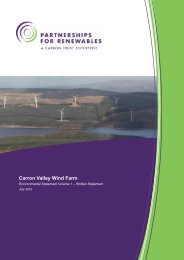
Planning Supporting Statement - Partnerships for Renewables
Planning Supporting Statement - Partnerships for Renewables
Planning Supporting Statement - Partnerships for Renewables

You also want an ePaper? Increase the reach of your titles
YUMPU automatically turns print PDFs into web optimized ePapers that Google loves.
Louth Canal Wind Energy Development<br />
2 Site Context<br />
2.1 The Development Site and Surroundings<br />
2.1.1 The proposed Development is located in the County of Lincolnshire to the south east of the<br />
village of Tetney (1.4km), Tetney Lock (2.3km), North Cotes (1.5km), and North Thoresby<br />
(3.2km). The Louth Canal <strong>for</strong>ms the eastern boundary of the site and the site is immediately<br />
surrounded by agricultural land on all sides. The site falls within the East Lindsey District<br />
Council administrative boundary.<br />
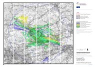
2.1.2 Figure 1.2 of the ES shows the Development Site Boundary and surrounding area. Part of the<br />
site is currently used by the Environment Agency, primarily as flood storage area <strong>for</strong> the Louth<br />
Canal during local flood events. The rest of the site is private land used <strong>for</strong> arable agricultural<br />
purposes. Both these uses would continue on the wider site following construction of the<br />
Development.<br />
2.1.3 The Louth Canal is located directly to the east of the site. A fish nursery is partially located<br />
within the site boundary, next to the canal, in the east of the site. This will be unaffected by the<br />
works. A small part of land within the flood storage area is designated as the Tetney Flood<br />
Local Wildlife Site (LWS), which is designated <strong>for</strong> its rich wetland and swamp flora.<br />
2.1.4 Tetney Blow Wells Site of Special Scientific Interest (SSSI) is located 0.6km north-west of the<br />
site, designated <strong>for</strong> its reed beds with base-rich fen and swamp vegetation associated with<br />
calcareous water of four large artesian springs. The Humber Estuary Special Area of<br />
Conservation (SAC), Ramsar, Special Protection Area (SPA) and SSSI is also located<br />
approximately 3.4km north-east of the proposed site.<br />
2.1.5 The landscape of Lincolnshire is typically flat rising significantly above sea level in very few<br />
places along the coast. The exception to this is the Lincolnshire Wolds Area of Outstanding<br />
Natural Beauty (AONB) which lies 6.2km to the west and reaches a height of 167m AOD<br />
providing expansive views of Lincolnshire to the east and west and onto Yorkshire in the north<br />
across the Humber. The Lincolnshire Wolds was designated as an AONB in 1973 to preserve<br />
the natural character of the area. The area comprises a series of low hills and steep valleys<br />
covering approximately 560 square kilometres and contains the highest ground in eastern<br />
England. Chalk hills and areas of sandstone and clay underlie this landscape with open valleys<br />
providing distant views across the surrounding low lying landscape.<br />
2.1.6 Locally designated Areas of Great Landscape Value (AGLV) lie on the eastern edge of the<br />
AONB, 5.2km from the site. The area broadly follows the boundary of the AONB. The area is<br />
designated in order to preserve and protect the distinctive character of the landscape by not<br />
permitting development that would harm the landscape features or detract from the value and<br />
enjoyment of the area.<br />
March 2012 3 <strong>Planning</strong> <strong>Supporting</strong> <strong>Statement</strong><br />
Copyright <strong>Partnerships</strong> <strong>for</strong> <strong>Renewables</strong> Development Co. Ltd 2012 ©