Non Technical Summary - Partnerships for Renewables
Non Technical Summary - Partnerships for Renewables
Non Technical Summary - Partnerships for Renewables

Create successful ePaper yourself
Turn your PDF publications into a flip-book with our unique Google optimized e-Paper software.
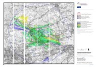
Landscaoe and Visual – Chapter 9 continued ><br />
principal views of some properties, such as those on Rooke<br />
Street in Parkhurst, will also limit the level of visual effect. For<br />
many visual receptors with potential medium distance views<br />
the proposed two turbines would be screened by the island’s<br />
distinct land<strong>for</strong>m especially the chalk ridge “spine” that runs<br />
west -east across its centre as well as relatively high levels<br />
of hedgerow, hedgerow tree, copse and plantation woodland<br />
that are characteristic of the two adjacent and extensive<br />
landscape character types and areas.<br />
Those receptors assessed as sustaining “substantial” or<br />
“moderate adverse effects” are generally a proportion<br />
of the residents in properties on the north-western edge<br />
of Newport or properties alongside or just off the A3020<br />
where their main views are likely to be to the north-west,<br />
west or south-west and where nearby screening is limited.<br />
In addition to the above “moderate adverse effects” may<br />
be sustained at sections of some public rights of way at<br />
separation distances of up to 3.5km or, in two instances,<br />
up to 5km. In no instance will public rights of way sustain<br />
“substantial adverse” or “very substantial adverse” effects.<br />
With regard to effects upon residential visual amenity a<br />
combination of separation distance, the screening of ground<br />
level operational elements and the narrowness of the turbine<br />
array <strong>for</strong>med by only two turbines would ensure that no<br />
residential visual receptors would reasonably have the<br />
sense that their property would be ‘widely regarded as an<br />
unattractive place to live’.<br />
Finally the cumulative landscape and visual assessment<br />
concluded that in only one area, around Bowcombe Down,<br />
would the combination of the Camp Hill Wind Energy<br />
Development with the other developments included in the<br />
assessment result in a higher level of visual effect than would<br />
be experienced in relation to the Camp Hill turbines on their<br />
own or the other developments excluding Camp Hill. There<br />
would be no significant cumulative landscape effects upon any<br />
landscape designations or landscape character types or areas.<br />
Cultural Heritage – Chapter 10<br />
Background historical and archaeological data was compiled<br />
and a site walkover survey undertaken in order to in<strong>for</strong>m<br />
the assessment. The assessment was undertaken in<br />
accordance with current best practice and policy guidance<br />
including Planning Policy Statement 5: Planning <strong>for</strong> the<br />
Historic Environment (Department of Communities and Local<br />
Government 2010), the Practice Guide (English Heritage<br />
2010), the Guidance Note on the Setting of Heritage Assets<br />
(2011) and the Local Unitary Development Plan. Consultation<br />
was undertaken with English Heritage and the Isle of Wight<br />
Planning Archaeologist.<br />
Designated heritage assets in the area were visited in<br />
order to assess the possible effect on their setting. Through<br />
experience of production of numerous Environmental<br />
Statements it has been demonstrated that significant effects<br />
rarely occur beyond a distance of 10km and the highest level<br />
effects are generally within 3.5km.<br />
Effects on listed buildings, conservation areas, scheduled<br />
monuments and registered historic parks and gardens<br />
within 5km were assessed; <strong>for</strong> example, the Carisbrooke<br />
Conservation Area, which includes both the parish Church of<br />
St Mary, a grade I listed building and Carisbrooke Castle, a<br />
scheduled monument and a grade I listed building all of which<br />
lie over 3km to the south of the development site. Assessment<br />
of Osborne House registered park and garden at 5km and the<br />
buildings at Parkhurst Prison and St Mary’s Hospital within<br />
1.5km of the development site was also undertaken.<br />
Whilst the wind turbines would <strong>for</strong>m a visible and<br />
recognisable new element within the landscape the<br />
assessment concluded that it would not detract from the<br />
character or significance of the surrounding heritage assets.<br />
However, the proposed development is assessed as having<br />
moderate adverse effect on the setting of the Carisbrooke<br />
Conservation Area together with the parish Church of St Mary<br />
as a result of the appearance of turbines within a specific<br />
number of views towards the church within the settlement.<br />
Moderate effects are also identified on Carisbrooke Castle.<br />
The physical effect on all heritage assets, including buried<br />
archaeological remains and other historic structures within<br />
the footprint of the proposed development, including<br />
associated services, construction compound, electrical cable<br />
connections and on/off site access routes was assessed<br />
through a desk study and site visit.<br />
The desk study comprised the identification of known<br />
designated and non-designated assets within the<br />
development area to assess the potential <strong>for</strong> effects on buried<br />
archaeological deposits and other historic features. This drew<br />
from the Isle of Wight Council Historic Environment Record,<br />
National Monument Record, historic Ordnance Survey maps<br />
and other available published resources in order to describe<br />
the history and development of the site.<br />
The assessment concluded that the potential <strong>for</strong> archaeological<br />
deposits to be affected during the construction phase is<br />
low with the exception of potential finds relating to the<br />
development site’s use as a rifle range during the late 19th<br />
and early 20th century in association with Parkhurst Barracks.<br />
Consequently a watching brief (archaeological supervision of<br />
works) would be undertaken during construction.<br />
Ecology – Chapter 11<br />
A desk study and field surveys were undertaken at the<br />
site in 2010 and 2011 including extended phase 1 habitat,<br />
dormouse, red squirrel, reptiles and bat surveys. Detailed bat<br />
survey work included an assessment of potential roost sites,<br />
manual bat detector transect surveys at dusk, dawn re-entry<br />
surveys of trees with roosting potential, static detector surveys<br />
at ground level and static detector surveys at height.<br />
Section continues overleaf ><br />
09