Non Technical Summary - Partnerships for Renewables
Non Technical Summary - Partnerships for Renewables
Non Technical Summary - Partnerships for Renewables

You also want an ePaper? Increase the reach of your titles
YUMPU automatically turns print PDFs into web optimized ePapers that Google loves.
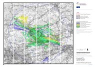
Landscaoe and Visual – Chapter 9 continued ><br />
• 10km from the proposed development <strong>for</strong> assessment<br />
of effects on local landscape character and the majority<br />
of visual receptors. This is referred to as the detailed study<br />
area and covers nearly all the areas of the Island from<br />
where the proposed turbines would be potentially visible;<br />
• 20km from the proposed development <strong>for</strong> assessment<br />
of effects on settlements, National Trails and national<br />
landscape designations; and<br />
• 40km from the proposed development <strong>for</strong><br />
cumulative effects.<br />
A cumulative scoping exercise was carried out which<br />
identified three wind energy developments and a biomass<br />
CHP plant with a tall chimney stack to be included in the<br />
cumulative assessment.<br />
The development site is not located within any national<br />
or local landscape planning designations and is located<br />
approximately 2.5km from the Isle of Wight Area of<br />
Outstanding Natural Beauty (AONB) and approximately 8km<br />
away from the New Forest National Park which is located on<br />
the mainland.<br />
The Isle of Wight Council has undertaken detailed studies<br />
which have characterised the different landscapes of the<br />
Isle of Wight. The proposed turbines are located within the<br />
Northern Woodlands’ landscape character type (LCT) which<br />
extends across Parkhurst Forest and some of its adjacent<br />
fields and the surrounding area is defined as Traditional<br />
Enclosed Pasture Land LCT or Calbourne Farmland<br />
Landscape Character Area (LCA).<br />
The development site is located on the eastern side of the<br />
395ha Parkhurst Forest which comprises of mature, mixed<br />
broadleaf and conifer woodland which extends around the<br />
development site’s western and northern edges. Another<br />
mature woodland, Noke Plantation, <strong>for</strong>ms the development<br />
site’s eastern edge providing it with a strong sense of<br />
enclosure. To the south is a valley containing a number of<br />
unkempt pasture fields which separate it from the HMP<br />
Isle of Wight site including Camp Hill, Albany and Parkhurst<br />
Barracks. Parkhurst Forest contains a number of trails which<br />
are open to public use but there is no public access to the<br />
site itself or in its immediate vicinity. There are moderate<br />
levels of public access approximately 1km from the<br />
proposed development.<br />
In the wider context there are ten long-distance trails mostly<br />
concentrated in the southern part of the island with the<br />
exception of the Isle of Wight Coastal Path which skirts the<br />
whole perimeter. These have been assessed and there will<br />
be no “substantial adverse” or “very substantial adverse”<br />
effects experienced at any of these receptors. The centre<br />
of Newport, the island’s largest town, lies some 2.8km to<br />
the south-east and its northern suburb of Parkhurst extends<br />
along the A3020 approximately 1km to the east. The small<br />
towns of Cowes and East Cowes also lie within 5km.<br />
Otherwise the prevailing settlement pattern in the detailed<br />
study area is of small settlements distributed in a medium<br />
density interspersed with farmsteads and isolated or small<br />
clusters of residential properties. There are also a number<br />
of holiday parks and tourist attractions 1.5km from the<br />
proposed development site and beyond.<br />
In terms of effects on the receptors mentioned above<br />
during the construction and de-commissioning phases both<br />
landscape and visual effects are considered to be temporary<br />
in nature and short term. This results in landscape and<br />
visual effects being not significant although there would<br />
be a limited number of visual receptors likely to sustain<br />
moderate adverse levels of visual effect during the shortlived<br />
period when the turbines are actually being erected by<br />
crane and their rotor blades attached. During construction<br />
and de-commissioning this relatively low level of landscape<br />
and visual effect is mainly due to the low numbers of close<br />
distance visual receptors and the screening of all ground<br />
level construction activities by the surrounding woodlands.<br />
During the 25-year operational period no significant effects<br />
have been identified that would be greater than “moderate<br />
adverse” on any landscape elements, character areas or<br />
types or upon landscape designations. Moderate adverse<br />
landscape effects have been identified <strong>for</strong> the Northern<br />
Woodlands LCT within which the wind energy development<br />
would be sited and the a<strong>for</strong>ementioned surrounding<br />
Traditional Enclosed Pasture Land LCT and Calbourne<br />
Farmland LCA. In the areas from which the turbines could<br />
potentially be seen, the separation distances from and the<br />
most valued attributes of the AONB and Heritage Coasts are<br />
assessed in detail and it is concluded that landscape effects<br />
would be no more than “slight adverse”. Consequently, no<br />
significant effects were identified <strong>for</strong> the Isle of Wight AONB,<br />
the Heritage Coast or the New Forest National Park.<br />
In addition to the nineteen agreed visualisation viewpoints<br />
the visual assessment included 118 individual or, more<br />
usually, groups of visual receptors located on the island<br />
and within 10km of the proposed development site. Of<br />
these visual receptors it is concluded that nine individuals<br />
or groups would be likely to sustain “substantial adverse”<br />
visual effects and a further twenty-four individual or groups<br />
would be likely or certain to sustain “moderate adverse”<br />
visual effects. However, no visual receptors would sustain<br />
“very substantial adverse” visual effects. These relatively<br />
low numbers of instances where “moderate” or “substantial”<br />
adverse visual effects would be experienced is due to the<br />
fact that there is, in fact, a relatively small number of visual<br />
receptors located in close proximity to the development site.<br />
Furthermore, screening provided by the high level of tree<br />
cover nearby will help to <strong>for</strong>eshorten many potential views<br />
<strong>for</strong> residents in properties such as those at the western<br />
end of Noke Common and Mark’s Corner. The aspect and<br />
Section continues overleaf ><br />
08